Abbeville, Georgia | |
|---|---|
 City hall (2014) | |
| Nickname: Wild Hog Capitol of Georgia [1] | |
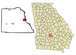 Location within Wilcox County and Georgia | |
| Coordinates: 31°59′30″N83°18′27″W / 31.99167°N 83.30750°W | |
| Country | United States |
| State | Georgia |
| County | Wilcox |
| Established | September 15, 1883 |
| Area | |
• Total | 3.09 sq mi (8.01 km2) |
| • Land | 3.06 sq mi (7.92 km2) |
| • Water | 0.039 sq mi (0.10 km2) |
| Elevation | 256 ft (78 m) |
| Population (2020) | |
• Total | 2,685 |
| • Density | 878.4/sq mi (339.17/km2) |
| Time zone | UTC-5 (Eastern (EST)) |
| • Summer (DST) | UTC-4 (EDT) |
| ZIP code | 31001 |
| Area code | 229 |
| FIPS code | 13-00184 [3] |
| GNIS feature ID | 0354256 [4] |
| Website | abbevillega.org |
Abbeville is a city in Wilcox County, Georgia, United States. As of the 2020 census, its population was 2,685. [5] The city is the county seat of Wilcox County. [6]

