Hazlehurst, Georgia

Last updated

Hazlehurst, Georgia
Hazlehurst City Hall.JPG
Hazlehurst City Hall
Flag of Hazlehurst, Georgia.png
Seal of Hazlehurst, Georgia.png
Motto: 
"Come linger' longer"
Jeff Davis County Georgia Incorporated and Unincorporated areas Hazlehurst Highlighted.svg
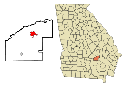
Location in Jeff Davis County and the state of Georgia
Coordinates: 31°51′58″N82°35′58″W / 31.86611°N 82.59944°W / 31.86611; -82.59944
Country United States
State Georgia
County Jeff Davis
Named for George Hazlehurst
Government
  MayorJohn Ramay
Area
[1]
  Total4.81 sq mi (12.45 km2)
  Land4.73 sq mi (12.26 km2)
  Water0.08 sq mi (0.20 km2)
Elevation
249 ft (76 m)
Population
 (2020)
  Total4,088
  Density863.72/sq mi (333.48/km2)
Time zone UTC-5 (Eastern (EST))
  Summer (DST) UTC-4 (EDT)
ZIP code
31539
Area code 912
FIPS code 13-37564 [2]
GNIS feature ID0315266 [3]
Website hazlehurstga.gov

Hazlehurst is a city in and the county seat of Jeff Davis County, Georgia, United States. [4] The population was 4,088 in 2020.

Contents

History

Initially called "Handtown" due to the Hand Family living in the area, it wasn't until the establishment of the railroad line from Macon to Brunswick that an actual community began to populate in the area. [5] It was formally founded circa 1880 as depot on the Macon and Brunswick Railroad. [6] The depot was first named "Milepost 8" before eventually gaining the name "Hazlehurst". [7] The community was named for railroad surveyor Col. George Hazlehurst. [8] In 1891, the community was incorporated as a town. [8] A courthouse was not built until 1907, after the formation of Jeff Davis County the previous year. [9]

A city in Mississippi was also named after him. [10]

Geography

Hazlehurst is located in southeast Georgia at 31°52′12″N82°35′37″W / 31.87000°N 82.59361°W / 31.87000; -82.59361 (31.870116775545718, -82.59377044041746).

Transportation

Hazlehurst is served by the intersection of U.S. routes 23, 221 and 341. U.S. 23 heads south, south-east for 25 miles towards Alma and north-west for 8 miles to Lumber City, while U.S. 341 travels south-east for roughly 16 miles to Baxley and joins U.S. 23 heading north-west towards Lumber City. U.S. 221 heads 29 miles north-east towards Vidalia and south-west for 31 miles to Douglas.

Aside from the Macon-Brunswick railroad running through the center of town, the Hazlehurst Municipal Airport, a roughly 165 acre facility located just northwest of the city. [11]

Climate

Climate data for Hazlehurst, Georgia, 1991–2020 normals, extremes 19182015
MonthJanFebMarAprMayJunJulAugSepOctNovDecYear
Record high °F (°C)85
(29)
84
(29)
93
(34)
95
(35)
102
(39)
105
(41)
107
(42)
104
(40)
106
(41)
97
(36)
88
(31)
85
(29)
107
(42)
Mean daily maximum °F (°C)60.3
(15.7)
64.1
(17.8)
70.9
(21.6)
77.8
(25.4)
85.1
(29.5)
89.7
(32.1)
92.4
(33.6)
91.4
(33.0)
86.6
(30.3)
78.7
(25.9)
69.8
(21.0)
62.5
(16.9)
77.4
(25.2)
Daily mean °F (°C)49.1
(9.5)
52.4
(11.3)
58.8
(14.9)
65.5
(18.6)
73.3
(22.9)
79.2
(26.2)
82.1
(27.8)
81.2
(27.3)
76.3
(24.6)
66.9
(19.4)
57.5
(14.2)
51.4
(10.8)
66.1
(19.0)
Mean daily minimum °F (°C)37.9
(3.3)
40.7
(4.8)
46.7
(8.2)
53.2
(11.8)
61.5
(16.4)
68.8
(20.4)
71.7
(22.1)
71.0
(21.7)
66.0
(18.9)
55.2
(12.9)
45.2
(7.3)
40.3
(4.6)
54.9
(12.7)
Record low °F (°C)10
(−12)
18
(−8)
20
(−7)
29
(−2)
40
(4)
47
(8)
58
(14)
56
(13)
45
(7)
28
(−2)
19
(−7)
15
(−9)
10
(−12)
Average precipitation inches (mm)4.15
(105)
4.21
(107)
4.41
(112)
3.65
(93)
3.30
(84)
5.28
(134)
4.50
(114)
6.87
(174)
4.47
(114)
2.95
(75)
2.98
(76)
4.09
(104)
50.86
(1,292)
Average snowfall inches (cm)0.0
(0.0)
0.1
(0.25)
0.0
(0.0)
0.0
(0.0)
0.0
(0.0)
0.0
(0.0)
0.0
(0.0)
0.0
(0.0)
0.0
(0.0)
0.0
(0.0)
0.0
(0.0)
0.0
(0.0)
0.1
(0.25)
Average precipitation days (≥ 0.01 in)10.410.29.17.67.112.512.413.311.48.67.19.7119.4
Average snowy days (≥ 0.1 in)0.00.10.00.00.00.00.00.00.00.00.00.00.1
Source 1: NOAA [12]
Source 2: XMACIS2 [13]

Demographics

Historical population
CensusPop.Note
1890 290
1900 793173.4%
1910 1,18148.9%
1920 1,38317.1%
1930 1,378−0.4%
1940 1,73225.7%
1950 2,68755.1%
1960 3,69937.7%
1970 4,0659.9%
1980 4,2985.7%
1990 4,202−2.2%
2000 3,787−9.9%
2010 4,22611.6%
2020 4,088−3.3%
U.S. Decennial Census [14]
Hazlehurst racial composition as of 2020 [15]
RaceNum.Perc.
White (non-Hispanic)2,07850.83%
Black or African American (non-Hispanic)1,35933.24%
Native American 90.22%
Asian 220.54%
Pacific Islander 30.07%
Other/Mixed 1233.01%
Hispanic or Latino 49412.08%

As of the 2020 United States census, there were 4,088 people, 1,494 households, and 894 families residing in the city.

Education

Jeff Davis County School District

The Jeff Davis County School District consists of two elementary schools, a middle school, and a high school. [16] The district has 210 classroom teachers and 3,075 students. [17]

Related Research Articles

<span class="mw-page-title-main">Wheeler County, Georgia</span> County in Georgia, United States

Wheeler County is a county located in the central portion of the U.S. state of Georgia. As of the 2020 census, the population was 7,471. The county seat is Alamo.

<span class="mw-page-title-main">Tift County, Georgia</span> County in Georgia, United States

Tift County is a county located in the south central portion of the U.S. state of Georgia. As of the 2020 census, the population was 41,344. The county seat is Tifton.

<span class="mw-page-title-main">Jeff Davis County, Georgia</span> County in Georgia, United States

Jeff Davis County is a county located in the southeastern part of the U.S. state of Georgia. As of the 2020 census, the population was 14,779. The county seat is Hazlehurst. The county was created on August 18, 1905, and named for Jefferson Davis, the only Confederate president.

<span class="mw-page-title-main">Appling County, Georgia</span> County in Georgia, United States

Appling County is a county located in the southeastern part of the U.S. state of Georgia. As of the 2020 census, the population was 18,444. The county seat is Baxley.

<span class="mw-page-title-main">Alma, Georgia</span> City in Georgia, United States

Alma is a city in Bacon County, Georgia, United States, and the county seat. As of the 2020 census, the city had a population of 3,433.

<span class="mw-page-title-main">Enigma, Georgia</span> Town in Georgia, United States

Enigma is a town in Berrien County, Georgia, United States. The population was 1,278 at the 2010 census, and 1,058 in 2020. The origin of the name "Enigma" is obscure; the name is itself an enigma. Enigma has frequently been noted on lists of unusual place names.

<span class="mw-page-title-main">Cochran, Georgia</span> City in Georgia, United States

Cochran is a city in Bleckley County, Georgia, United States. As of the 2020 census, the city had a population of 5,026. The city is the county seat of Bleckley County.

<span class="mw-page-title-main">Chauncey, Georgia</span> City in Georgia, United States

Chauncey is a city in Dodge County, Georgia, United States. The population was 289 at the 2020 census. It was formed around station number twelve on the Macon and Brunswick Railroad.

<span class="mw-page-title-main">Eastman, Georgia</span> City in Georgia, United States

Eastman is a city in Dodge County, Georgia, United States. The population was 5,658 at the 2020 census, up from 4,962 at the 2010 census. The city was named after William Pitt Eastman, a native of Massachusetts who purchased a large tract of land along the Macon and Brunswick Railroad, and settled a city on the site.

<span class="mw-page-title-main">Ocilla, Georgia</span> City in Georgia, United States

The city of Ocilla is the county seat of Irwin County, Georgia, United States. Its population was 3,498 at the 2020 census. Ocilla is part of the Fitzgerald micropolitan statistical area.

<span class="mw-page-title-main">Mount Vernon, Georgia</span> City in Georgia, United States

Mount Vernon is a city in, and the county seat of, Montgomery County, Georgia, United States. The population was 1,900 at the 2020 census, down from 2,451 in 2010. It is home to Brewton–Parker College.

<span class="mw-page-title-main">Uvalda, Georgia</span> City in Georgia, United States

Uvalda is a city in Montgomery County, Georgia, United States. The population was 439 at the 2020 census, down from 598 in 2010.

<span class="mw-page-title-main">Lumber City, Georgia</span> City in Georgia, United States

Lumber City is a city located in Telfair County, Georgia, United States. As of the 2020 census, the city had a total population of 967.

<span class="mw-page-title-main">McRae, Georgia</span> City in Georgia, United States

McRae was a city in and the county seat of Telfair County, Georgia, United States. It was designated as the seat in 1871, after being established the previous year as a station on the Macon and Brunswick Railroad. Upon the city's merger with adjacent Helena in 2015, the new county seat is the combined city of McRae-Helena.

<span class="mw-page-title-main">Jesup, Georgia</span> City in Georgia, United States

Jesup is a city in Wayne County, Georgia, United States. The population was 9,809 at the 2020 census. The city is the county seat of Wayne County.

<span class="mw-page-title-main">Alamo, Georgia</span> Town in Georgia, United States

Alamo is a town in Wheeler County, Georgia, United States. As of the 2020 census, the town had a population of 771. The town is the county seat of Wheeler County.

<span class="mw-page-title-main">Georgia State Route 19</span> State highway in central Georgia

State Route 19 (SR 19) is a 152-mile-long (245 km) state highway that travels southeast-to-northwest through portions of Bacon, Jeff Davis, Appling, Telfair, Wheeler, Laurens, Twiggs, Bibb, and Monroe counties in the central part of the U.S. state of Georgia. The highway travels from its southern terminus at US 1/US 23/SR 4 north of Alma to its northern terminus at US 41/SR 18 in Forsyth. It also travels through Hazlehurst, Lumber City, Dublin, and Macon.

<span class="mw-page-title-main">West Green, Georgia</span> Unincorporated community in Georgia, US

West Green is an unincorporated community in Coffee County, Georgia, United States. West Green is located along U.S. Route 221 northeast of Douglas and southwest of Lehigh near the Coffee-Jeff Davis County Line. The ZIP Code for West Green is 31567.

<span class="mw-page-title-main">Macon and Brunswick Railroad</span> 19th-century line in Georgia, U.S.

The Macon and Brunswick Railroad ran from Macon, Georgia to Brunswick, Georgia. Its construction was interrupted by the American Civil War, and initially only ran from Macon to Cochran, Georgia. The 5 ft gauge line was completed and extended to the Georgia coast when it opened in its entirety in December 1869. Construction of the line stimulated the lumber industry along its path, and the founding of new towns and counties.

<span class="mw-page-title-main">McRae–Helena, Georgia</span> City in Georgia, United States

McRae–Helena is a city in the U.S. state of Georgia, formed on January 1, 2015, by the merger of the two cities of McRae and Helena. McRae–Helena is the county seat of Telfair County.

References

  1. "2020 U.S. Gazetteer Files". United States Census Bureau. Retrieved December 18, 2021.
  2. "U.S. Census website". United States Census Bureau . Retrieved January 31, 2008.
  3. "US Board on Geographic Names". United States Geological Survey. October 25, 2007. Retrieved January 31, 2008.
  4. "Find a County". National Association of Counties. Retrieved June 7, 2011.
  5. Anderson, Mary Ann (June 16, 2018). "Learning About Jeff Davis County". Jeff Davis Ledger. Retrieved August 27, 2024.
  6. Hellmann, Paul T. (May 13, 2013). Historical Gazetteer of the United States. Routledge. p. 233. ISBN   978-1135948597 . Retrieved November 30, 2013.
  7. "Colonel Hazlehurst". City of Hazlehurst. Retrieved August 27, 2024.
  8. 1 2 Krakow, Kenneth K. (1975). Georgia Place-Names: Their History and Origins (PDF). Macon, GA: Winship Press. p. 106. ISBN   0-915430-00-2.
  9. "History of Jeff Davis County". GA GenWeb. Retrieved August 27, 2024.
  10. Gannett, Henry (1905). The Origin of Certain Place Names in the United States. Govt. Print. Off. pp.  153.
  11. "Hazlehurst Municipal Airport". City of Hazlehurst. Retrieved August 28, 2024.
  12. "U.S. Climate Normals Quick Access – Station: Hazlehurst, GA". National Oceanic and Atmospheric Administration. Retrieved February 27, 2023.
  13. "xmACIS2". National Oceanic and Atmospheric Administration. Retrieved February 27, 2023.
  14. "Census of Population and Housing". Census.gov. Retrieved June 4, 2015.
  15. "Explore Census Data". data.census.gov. Retrieved December 18, 2021.
  16. Georgia Board of Education [ permanent dead link ], Retrieved June 20, 2010.
  17. National Center for Educational Statistics, Retrieved April 1, 2024