Ashburn, Georgia

Last updated

Ashburn, Georgia
Ashburn City Hall SE corner.JPG
Ashburn City Hall
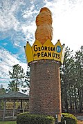
Nickname: 
Peanut Capital of the World
Turner County Georgia Incorporated and Unincorporated areas Ashburn Highlighted.svg
Location in Turner County and the state of Georgia
Coordinates: 31°42′16″N83°39′14″W / 31.70444°N 83.65389°W / 31.70444; -83.65389
CountryUnited States
State Georgia
County Turner
Government
   Mayor Sandra Lumpkin
Area
[1]
  Total4.80 sq mi (12.43 km2)
  Land4.75 sq mi (12.29 km2)
  Water0.05 sq mi (0.14 km2)
Elevation
427 ft (130 m)
Population
 (2020)
  Total4,291
  Density904.13/sq mi (349.12/km2)
Time zone UTC-5 (EST)
  Summer (DST) UTC-4 (EDT)
ZIP code
31714
Area code 229
FIPS code 13-03236 [2]
GNIS feature ID0354404 [3]
Website https://www.cityofashburn.net

The city of Ashburn is the county seat of Turner County, Georgia, United States. As of 2020, its population was 4,291. Ashburn's government is classified as a council/manager form of municipal government.

Contents

Ashburn is noted for its peanuts and a fire ant festival.

History

The town of Marion was founded in 1888, and changed its name to Ashburn when it was incorporated in 1890. Ashburn was designated seat of Turner County when it was established in 1905. [4] The community was named after W. W. Ashburn, a pioneer citizen. [5]

Peanut Statue

In 1975, the Peanut Statue was constructed in Ashburn and was then considered an official state monument in 1998. In the year 2019 it was destroyed by Hurricane Micheal. The newer Peanut Statute appears smaller than the original peanut statue, although the exact measurements are unknown. The woods that the original peanut was next to was cleared out, and the small picnic table as seen in the first image was presumably destroyed by Hurricane Micheal, the same hurricane that destroyed the original peanut statue.

The small tower constructed of brick was reused for the newer peanut statue, as was the crown. The original peanut statue was made of fiberglass. The brick tower is 15 feet tall and has a crown attached to it. [6]

Legal Publications for the City of Ashburn is The Wiregrass Farmer.

Geography

Ashburn is located at 31°42′16″N83°39′14″W / 31.70444°N 83.65389°W / 31.70444; -83.65389 (31.704378, -83.653786). [7]

According to the United States Census Bureau, the city has a total area of 4.6 square miles (12 km2), of which 4.5 square miles (12 km2) is land and 0.04 square miles (0.10 km2) (0.66%) is water.

Demographics

Historical population
CensusPop.Note
1890 403
1900 1,301222.8%
1910 2,21470.2%
1920 2,116−4.4%
1930 2,073−2.0%
1940 2,2669.3%
1950 2,91828.8%
1960 3,29112.8%
1970 4,20927.9%
1980 4,76613.2%
1990 4,8271.3%
2000 4,419−8.5%
2010 4,152−6.0%
2020 4,2913.3%
U.S. Decennial Census [8]
Ashburn racial composition as of 2020 [9]
RaceNum.Perc.
White (non-Hispanic)1,10925.84%
Black or African American (non-Hispanic)2,83165.98%
Native American 30.07%
Asian 370.86%
Other/Mixed 1192.77%
Hispanic or Latino 1924.47%

As of the 2020 United States census, there were 4,291 people, 1,500 households, and 1,061 families residing in the city.

Education

Schools

Ashburn residents are served by the Turner County School District which offers pre-school through grade twelve education, and has one elementary school, a middle school, a high school, and a speciality school. [10] The district has 126 full-time teachers and over 1,145 students. [11]

Library

Ashburn is served by a public library, the Victoria Evans Memorial Library. [12]

Events

The original peanut statue Peanut monument, Ashburn, GA, US.jpg
The original peanut statue
Peanut statue rebuilt in 2023 Peanut statue rebuilt in 2023, Ashburn, GA, US.jpg
Peanut statue rebuilt in 2023

Every fourth weekend in March, Ashburn holds the Fire Ant Festival. This offers an art show, carnival rides, a car show, strawberry cook off, BBQ competition, health show, and fireworks. Some events are tailored to the festival itself, such as the Fire Ant Call, Find the Fire Ant, Fire Ant 5k, and Miss Fire Ant Pageant.

The newer Peanut Statute appears smaller than the original peanut statue, although the exact measurements are unknown. The woods that the original peanut was next to was cleared out, and the small picnic table as seen in the first image was presumably destroyed by Hurricane Micheal, the same hurricane that destroyed the original peanut statue.

The small tower constructed of brick was reused for the newer peanut statue, as was the crown. The peanut statue was erected in 1975, and was officially recognized as an official state monument in the year 1998. The original peanut statue was made of fiberglass. The brick tower is 15 feet tall and has a crown attached to it. [13]

Notable people

Related Research Articles

<span class="mw-page-title-main">Turner County, Georgia</span> County in Georgia, United States

Turner County is a county located in the south central portion of the U.S. state of Georgia. As of the 2020 census, the population was 9,006. The county seat is Ashburn. The county was created on August 18, 1905, and named for Henry Gray Turner, U.S. representative and Georgia state Supreme Court justice.

<span class="mw-page-title-main">Tift County, Georgia</span> County in Georgia, United States

Tift County is a county located in the south central portion of the U.S. state of Georgia. As of the 2020 census, the population was 41,344. The county seat is Tifton.

<span class="mw-page-title-main">Jackson County, Georgia</span> County in Georgia, United States

Jackson County is a county located in the northeastern part of the U.S. state of Georgia. As of the 2020 census, the population was 75,907. The county seat is Jefferson.

<span class="mw-page-title-main">Bleckley County, Georgia</span> County in Georgia, United States

Bleckley County is a county located in the central portion of the U.S. state of Georgia. As of the 2020 census, the population was 12,583. The county seat is Cochran.

<span class="mw-page-title-main">Enterprise, Alabama</span> City in Coffee County, Alabama, US

Enterprise is a city in the southeastern part of Coffee County and the southwestern part of Dale County in Southeastern Alabama, United States. Its population was 28,711 at the 2020 census. Enterprise is the primary city of the Enterprise micropolitan statistical area. It was originally a part of Enterprise–Ozark micropolitan area before being split; for a longer while it was originally part of the Dothan-Enterprise-Ozark combined statistical area but is now its own separate primary statistical area in later censuses.

<span class="mw-page-title-main">Dothan, Alabama</span> City in and county seat of Houston County, Alabama

Dothan( DOH-thən) is a city in and the county seat of Houston County in the U.S. state of Alabama. A slight portion of the city extends into Dale and Henry counties. It had a population of 71,072 at the 2020 census, making it Alabama's eighth-largest city by population and the 5th largest in Alabama by total area. It is near the state's southeastern corner, about 20 miles (32 km) west of Georgia and 16 miles (26 km) north of Florida. It is named after the biblical city where Joseph's brothers threw him into a cistern and sold him into slavery in Egypt.

<span class="mw-page-title-main">Fitzgerald, Georgia</span> City in Georgia, United States

Fitzgerald is a city in and the county seat of Ben Hill County in the south central portion of the U.S. state of Georgia. As of 2020, its population was 9,006. It is the principal city of the Fitzgerald micropolitan statistical area, which includes all of Ben Hill and Irwin counties.

<span class="mw-page-title-main">Cordele, Georgia</span> City in Georgia, United States

Cordele is a city in and the county seat of Crisp County, Georgia. The population was 11,165 at the 2010 census, and 10,220 in 2020.

<span class="mw-page-title-main">Sparta, Georgia</span> City in Georgia, United States

Sparta is a city in and the county seat of Hancock County, Georgia, United States. It is part of the Milledgeville micropolitan statistical area. The city's population was 1,400 at the 2010 census.

<span class="mw-page-title-main">Buena Vista, Georgia</span> City in Georgia, United States

Buena Vista is a city in Marion County, Georgia, United States. It is part of the Columbus, Georgia-Alabama metropolitan statistical area. The population was 1,585 at the 2020 census, down from 2,173 in 2010. Formerly known as "Pea Ridge", the city changed its name to Buena Vista in honor of Zachary Taylor's victory in the Mexican–American War. The city is the county seat of Marion County. It is the birthplace of baseball legend Josh Gibson and Medal of Honor recipient Luther H. Story.

<span class="mw-page-title-main">Plains, Georgia</span> City in Georgia, United States

Plains is a city in Sumter County, Georgia, United States. The population was 573 at the 2020 census and it is a part of the Americus Micropolitan Statistical Area. It is best known as the birthplace of Jimmy Carter and his wife Rosalynn, who were the president and first lady of the United States respectively from 1977 to 1981. They lived in Plains both before and after their time in the White House.

<span class="mw-page-title-main">Tifton, Georgia</span> City in Georgia, United States

Tifton is a city in and the county seat of Tift County, Georgia, United States. The population was 17,045 at the 2020 census.

<span class="mw-page-title-main">Rochelle, Georgia</span> City in Georgia, United States

Rochelle is a city in Wilcox County, Georgia, United States. Per the 2020 census, the population was 1,167.

<span class="mw-page-title-main">Sylvester, Georgia</span> City in Georgia, United States

Sylvester is the county seat of Worth County, Georgia, United States. The population was 5,644 in 2020. The city is the county seat and business center of Worth County and is claimed to be the Peanut Capital of the World due to its peanut production.

<span class="mw-page-title-main">Purvis, Mississippi</span> City in Mississippi, United States

Purvis is a U.S. city in and the county seat of Lamar County, Mississippi. It is part of the Hattiesburg, Mississippi Metropolitan Statistical Area. The population was 2,175 at the 2010 census. The Town of Purvis was incorporated on February 25, 1888 and was founded by and named after Thomas Melville Purves, originally of Marion County, Alabama. Purves, born March 8, 1820, was a second generation Scottish-American; his grandfather emigrated to Charleston, South Carolina in 1765.

<span class="mw-page-title-main">Ashburn, Virginia</span> Census-designated place in Virginia, United States

Ashburn is a rapidly growing census-designated place (CDP) in Loudoun County, Virginia, United States. At the 2010 United States census, its population was 43,511, up from 3,393 in 1990. It is 30 miles (48 km) northwest of Washington, D.C., and part of the Washington metropolitan area.

The Wiregrass Farmer is reported to be the second newspaper created by Irish immigrant Joe Lawrence.

<span class="mw-page-title-main">Turner County Courthouse</span> United States historic place

Turner County Courthouse is a historic county courthouse in Ashburn, Georgia, the county seat of Turner County, Georgia. The Classical Revival building was designed by two Macon architects, Alexander Blair III and Peter E. Dennis. The courthouse is located at 219 East College Avenue, close to several historic homes.

<span class="mw-page-title-main">Nora Lawrence Smith</span> American journalist and newspaper publisher

Nora Lawrence Smith was a newspaper publisher and activist in Ashburn, Georgia. She has been called a "pioneer among women publishers" and "one of the best known and most respected weekly editors in the state." In 1974 she became the first woman inducted into the Georgia Newspaper Hall of Fame.

<span class="mw-page-title-main">Jimmy Carter Peanut Statue</span> Monument

The Jimmy Carter Peanut Statue is a monument located in Plains, Georgia, United States. Built in 1976, the roadside attraction depicts a large peanut with a big smile, and was built to support Jimmy Carter during the 1976 United States presidential election.

References

  1. "2020 U.S. Gazetteer Files". United States Census Bureau. Retrieved December 18, 2021.
  2. "U.S. Census website". United States Census Bureau . Retrieved January 31, 2008.
  3. "US Board on Geographic Names". United States Geological Survey. October 25, 2007. Retrieved January 31, 2008.
  4. Hellmann, Paul T. (May 13, 2013). Historical Gazetteer of the United States. Routledge. p. 217. ISBN   978-1135948597 . Retrieved November 30, 2013.
  5. Krakow, Kenneth K. (1975). Georgia Place-Names: Their History and Origins. Macon, GA: Winship Press. p. 8. ISBN   0-915430-00-2.
  6. https://clui.org/ludb/site/peanut-monument
  7. "US Gazetteer files: 2010, 2000, and 1990". United States Census Bureau. February 12, 2011. Retrieved April 23, 2011.
  8. "Census of Population and Housing". Census.gov. Retrieved June 4, 2015.
  9. "Explore Census Data". data.census.gov. Retrieved December 18, 2021.
  10. [0=field_district:154|date=July 2019|Retrieved December 1, 2021.
  11. School Stats Archived 2016-03-03 at the Wayback Machine , Retrieved June 29, 2010.
  12. "Homepage". Victoria Evans Memorial Library. Archived from the original on September 7, 2008. Retrieved December 1, 2021.
  13. https://clui.org/ludb/site/peanut-monument#:~:text=The%20world's%20largest%20peanut%20was,cylinder%20with%20a%20golden%20crown.