Cartersville, Georgia

Last updated

Cartersville, Georgia
Cartersville Georgia City Hall 2015.jpg
Cartersville City Hall
Bartow County Georgia Incorporated and Unincorporated areas Cartersville Highlighted.svg
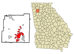
Location in Bartow County, Georgia
Metro atlanta.jpg
Red pog.svg
Cartersville
Location of Cartersville in Metro Atlanta
Coordinates: 34°11′N84°48′W / 34.183°N 84.800°W / 34.183; -84.800
Country United States
State Georgia
County Bartow
Incorporated 1850
Named for Farish Carter [1] [2]
Government
   Mayor Matt Santini
Area
[3]
  Total28.74 sq mi (74.44 km2)
  Land28.62 sq mi (74.12 km2)
  Water0.12 sq mi (0.32 km2)
Elevation
787 ft (240 m)
Population
 (2020)
  Total23,187
  Density810.20/sq mi (312.82/km2)
Time zone UTC−5 (Eastern Time)
  Summer (DST) UTC−4 (Eastern Daylight Time)
ZIP Codes
30120, 30121
Area code(s) 770/678/470
FIPS code 13-13688 [4]
GNIS feature ID0355017 [5]
Website www.cityofcartersville.org

Cartersville is a city in Bartow County, Georgia, United States; it is located within the northwest edge of the Atlanta metropolitan area. As of the 2020 census, the city had a population of 23,187. Cartersville is the county seat of Bartow County. [6]

Contents

History

Cartersville, originally known as Birmingham, was founded by English-Americans in 1832. [7] The town was incorporated as Cartersville in 1854. [7] The present name is for Col. Farish Carter of Milledgeville, the owner of a large plantation. [8] [9] Cartersville was the long-time home of Amos Akerman, U.S. Attorney General under President Ulysses S. Grant; in that office he spearheaded the federal prosecution of members of the Ku Klux Klan and was one of the most important public servants of the Reconstruction era. [10]

Cartersville was designated the seat of Bartow County in 1867 following the destruction of Cassville by Sherman's March to the Sea in American Civil War. Cartersville was incorporated as a city in 1872. [11]

On February 26, 1916, a group of 100 men and boys took Jesse McCorkle from the jail and hanged him from a tree in front of the city hall and riddled his body with bullets. [12]

Geography

Cartersville is located in south-central Bartow County, 42 miles (68 km) northwest of downtown Atlanta and 76 miles (122 km) southeast of Chattanooga, Tennessee.

The Etowah River flows through a broad valley south of the downtown, leading west to Rome, where it forms the Coosa River, a tributary of the Alabama River. The city limits extend eastward, upriver, as far as Allatoona Dam, which forms Lake Allatoona, a large U.S. Army Corps of Engineers reservoir. Red Top Mountain State Park sits on a peninsula in the lake, just outside the city limits. Nancy Creek also flows in the vicinity. The highest point in the city is 1,562 feet (476 m) at the summit of Pine Mountain. [13]

According to the U.S. Census Bureau, Cartersville has a total area of 29.3 square miles (75.9 km2), of which 29.2 square miles (75.5 km2) is land and 0.15 square miles (0.4 km2), or 0.59%, is water. [14]

Transportation

Interstate 75, the major north-south route through the area, passes through the eastern edge of the city, with access from five exits: Exit 285 just south of the city limits in Emerson, Exit 288 (East Main Street) closest to downtown, and exits 290, 293, and 296 along the city's northern outskirts. U.S. Highway 41, which is concurrent with State Route 3, is an older, parallel highway to Interstate 75 that goes through the eastern edge of downtown, leading north to Calhoun and Dalton and south to Marietta. U.S. Highway 411 passes through the northern edge of the city, leading west to Rome and north to Chatsworth. State Route 20 runs west to Rome concurrent with U.S. Highway 411 and runs east to Canton. State Route 61 runs north to White concurrent with U.S. Highway 411 and runs south to Dallas, Georgia. State Route 113 runs southwesterly to Rockmart. State Route 293 runs west-northwest to Kingston.

Cartersville Airport is a public use airport located in the west side of Cartersville on State Route 61. It is the home base of Phoenix Air.

Cartersville area communities

The following communities border the city:

Climate

Climate data for Cartersville, Georgia (Cartersville Airport), 1991–2020 normals, extremes 18912019
MonthJanFebMarAprMayJunJulAugSepOctNovDecYear
Record high °F (°C)79
(26)
83
(28)
88
(31)
93
(34)
100
(38)
106
(41)
108
(42)
108
(42)
106
(41)
100
(38)
87
(31)
82
(28)
108
(42)
Mean maximum °F (°C)68.2
(20.1)
73.0
(22.8)
80.9
(27.2)
85.7
(29.8)
89.1
(31.7)
93.9
(34.4)
96.2
(35.7)
95.5
(35.3)
92.0
(33.3)
84.7
(29.3)
77.1
(25.1)
69.0
(20.6)
97.5
(36.4)
Mean daily maximum °F (°C)52.2
(11.2)
56.8
(13.8)
64.9
(18.3)
73.4
(23.0)
80.7
(27.1)
86.9
(30.5)
89.6
(32.0)
89.1
(31.7)
84.2
(29.0)
74.0
(23.3)
62.9
(17.2)
54.5
(12.5)
72.4
(22.5)
Daily mean °F (°C)41.8
(5.4)
45.5
(7.5)
52.5
(11.4)
60.2
(15.7)
68.3
(20.2)
75.6
(24.2)
78.8
(26.0)
78.1
(25.6)
72.5
(22.5)
61.6
(16.4)
50.8
(10.4)
44.3
(6.8)
60.8
(16.0)
Mean daily minimum °F (°C)31.4
(−0.3)
34.3
(1.3)
40.2
(4.6)
47.0
(8.3)
56.0
(13.3)
64.2
(17.9)
68.0
(20.0)
67.2
(19.6)
60.7
(15.9)
49.1
(9.5)
38.7
(3.7)
34.0
(1.1)
49.2
(9.6)
Mean minimum °F (°C)12.7
(−10.7)
17.0
(−8.3)
23.8
(−4.6)
30.6
(−0.8)
41.1
(5.1)
52.5
(11.4)
60.1
(15.6)
59.5
(15.3)
46.0
(7.8)
32.7
(0.4)
25.6
(−3.6)
16.0
(−8.9)
9.3
(−12.6)
Record low °F (°C)−9
(−23)
−6
(−21)
8
(−13)
22
(−6)
31
(−1)
40
(4)
49
(9)
48
(9)
30
(−1)
23
(−5)
4
(−16)
−3
(−19)
−9
(−23)
Average precipitation inches (mm)4.29
(109)
4.69
(119)
4.72
(120)
4.15
(105)
3.67
(93)
3.79
(96)
3.88
(99)
3.44
(87)
3.63
(92)
3.25
(83)
4.06
(103)
4.49
(114)
48.06
(1,220)
Average snowfall inches (cm)0.4
(1.0)
0.1
(0.25)
0.0
(0.0)
0.0
(0.0)
0.0
(0.0)
0.0
(0.0)
0.0
(0.0)
0.0
(0.0)
0.0
(0.0)
0.0
(0.0)
0.0
(0.0)
0.1
(0.25)
0.6
(1.5)
Average precipitation days (≥ 0.01 in)10.811.911.210.311.312.414.210.79.49.29.110.8131.3
Average snowy days (≥ 0.1 in)0.10.10.00.00.00.00.00.00.00.00.00.00.2
Source 1: NOAA (snow/snow days 19812010) [15] [16]
Source 2: National Weather Service (mean maxima/minima 19812010) [17]

Demographics

Historical population
CensusPop.Note
1870 2,232
1880 2,037−8.7%
1890 3,17155.7%
1900 3,135−1.1%
1910 4,06729.7%
1920 4,3507.0%
1930 5,25020.7%
1940 6,14117.0%
1950 7,27018.4%
1960 8,66819.2%
1970 10,13817.0%
1980 9,247−8.8%
1990 12,03530.2%
2000 15,92532.3%
2010 19,73123.9%
2020 23,18717.5%
U.S. Decennial Census [18]

2020 census

Cartersville racial composition [19]
RaceNum.Perc.
White (non-Hispanic)14,60863.0%
Black or African American (non-Hispanic)4,14417.87%
Native American 500.22%
Asian 3461.49%
Pacific Islander 110.05%
Other/Mixed 9774.21%
Hispanic or Latino 3,05113.16%

As of the 2020 United States census, there were 23,187 people, 7,835 households, and 5,285 families residing in the city.

2010 census

As of the census [4] of 2010, there were 19,010 people, 5,870 households, and 4,132 families residing in the city. The population of Cartersville is growing significantly. The population density was 680.7 inhabitants per square mile (262.8/km2). There were 6,130 housing units at an average density of 262.0 per square mile (101.2/km2). The racial makeup of the city was 63.93% White, 29.64% African American, 0.82% Asian, 0.28% Native American, 0.04% Pacific Islander, 3.76% from other races, and 1.53% from two or more races. Hispanic or Latino people of any race were 7.28% of the population.

There were 5,870 households, out of which 33.3% had children under the age of 18 living with them, 52.6% were married couples living together, 13.6% had a female householder with no husband present, and 29.6% were non-families. 25.9% of all households were made up of individuals, and 11.7% had someone living alone who was 65 years of age or older. The average household size was 2.59 and the average family size was 3.10.

In the city, the population was spread out, with 25.9% under the age of 18, 8.7% from 18 to 24, 30.2% from 25 to 44, 20.8% from 45 to 64, and 14.4% who were 65 years of age or older. The median age was 36 years. For every 100 females, there were 95.4 males. For every 100 females age 18 and over, there were 92.1 males.

The median income for a household in the city was $41,162, and the median income for a family was $48,219. Males had a median income of $35,092 versus $25,761 for females. The per capita income for the city was $19,977. About 8.9% of families and 11.4% of the population were below the poverty line, including 13.7% of those under age 18 and 15.4% of those age 65 or over.

Points of interest

Booth Western Art Museum Booth Western Art Museum.jpg
Booth Western Art Museum

Education

The schools that comprise the Cartersville City School System are:

There is also a private Montessori school:

Cartersville also has a college campus:

Economy

Manufacturing, tourism, and services play a part in the economy of the city. The city's employers include:

The city is home to Piedmont Cartersville Medical Center and The Hope Center, making it a minor healthcare hub for the surrounding area.[ citation needed ]

Law enforcement

In 2017, the Cartersville Police Department arrested 65 people at a house party because of a suspicion that there was an ounce of marijuana at the party. In 2022, a federal court awarded 45 of the arrested individuals a $900,000 settlement due to a violation of their constitutional rights. [26]
On September 8, 2022, Deputy Police Chief Jason DiPrima resigned after being arrested in a prostitute police-sting operation. [27] [28]

Notable people

Related Research Articles

<span class="mw-page-title-main">Cobb County, Georgia</span> County in Georgia, United States

Cobb County is a county in the U.S. state of Georgia, located in the Atlanta metropolitan area in the north central portion of the state. As of 2020 Census, the population was 766,149. It is the state's third most populous county, after Fulton and Gwinnett counties. Its county seat is Marietta; its largest city is Mableton.

<span class="mw-page-title-main">Cherokee County, Georgia</span> County in Georgia, United States

Cherokee County is located in the US state of Georgia. As of the 2020 Census, the population was 266,620. The county seat is Canton. The county Board of Commissioners is the governing body, with members elected to office. Cherokee County is included in the Atlanta Metropolitan Area.

<span class="mw-page-title-main">Bartow County, Georgia</span> County in Georgia, United States

Bartow County is located in the northwestern part of the U.S. state of Georgia. As of the 2020 census, the population was 108,901, up from 100,157 in 2010. The county seat is Cartersville.

<span class="mw-page-title-main">Adairsville, Georgia</span> City in Georgia, United States

Adairsville is a city in Bartow County, Georgia, United States. As of the 2020 census, the city had a population of 4,878. Adairsville is approximately halfway between Atlanta and Chattanooga on Interstate 75. It is 12 miles (19 km) south of Calhoun, 18 miles (29 km) northeast of Rome and 61 miles (98 km) north of Atlanta.

<span class="mw-page-title-main">Euharlee, Georgia</span> City in Georgia, United States

Euharlee is a city in Bartow County, Georgia, United States. The population was 4,136 at the 2010 census, an increase of 29% over the 2000 count of 3,208.

<span class="mw-page-title-main">Kingston, Georgia</span> City in Georgia, United States

Kingston is a village in Bartow County, Georgia, United States. The population was 722 at the 2020 census.

<span class="mw-page-title-main">Canton, Georgia</span> City in Georgia, United States

Canton is a city in and the county seat of Cherokee County, Georgia, United States. As of the 2010 census, the city had a population of 22,958, up from 7,709 in 2000.

<span class="mw-page-title-main">Acworth, Georgia</span> City in Georgia, United States

Acworth is a city in Cobb County, Georgia, United States. It is part of the Atlanta metropolitan area. As of the 2020 census, this city had a population of 22,440, up from 20,425 in 2010. Acworth is located in the foothills of the North Georgia mountains along the southeastern banks of Lake Acworth and Lake Allatoona on the Etowah River. Unincorporated areas known as Acworth extend into Bartow, Cherokee and Paulding counties.

<span class="mw-page-title-main">Douglasville, Georgia</span> City in Georgia, United States

The city of Douglasville is the county seat of and largest city in Douglas County, Georgia, United States. As of the 2020 census, the city had a population of 34,650, up from 30,961 in 2010 and 20,065 in 2000.

<span class="mw-page-title-main">Etowah River</span> River in Georgia, U.S.

The Etowah River is a 164-mile-long (264 km) waterway that rises northwest of Dahlonega, Georgia, north of Atlanta. On Matthew Carey's 1795 map the river was labeled "High Town River". On later maps, such as the 1839 Cass County map, it was referred to as "Hightower River", a name that was used in most early Cherokee records.

<span class="mw-page-title-main">U.S. Route 411</span> Numbered U.S. Highway in Alabama, Georgia, and Tennessee in the United States

U.S. Route 411 (US 411) is an alternate parallel-highway associated with US 11. It extends for about 309.7 miles (498.4 km) from US 78 in Leeds, Alabama, to US 25W/US 70 in Newport, Tennessee. US 411 travels through northeastern Alabama, northwestern Georgia, and southeastern Tennessee. It is signed north-south, as with most highways that have odd numbers, but the route runs primarily in a northeast-southwest direction, and covers a more east-west mileage than it does north-south. Notable towns and cities along its route include Gadsden, Alabama; Rome, Georgia; Cartersville, Georgia; Maryville, Tennessee; Sevierville, Tennessee, and Newport, Tennessee.

<span class="mw-page-title-main">Lake Allatoona</span> Reservoir in Georgia, United States

Lake Allatoona is a U.S. Army Corps of Engineers reservoir on the Etowah River in northwestern part of the State of Georgia. This reservoir is mostly in southeastern Bartow County and southwestern Cherokee County. A small portion is located in Cobb County near Acworth.

<span class="mw-page-title-main">Cassville, Georgia</span> Unincorporated community in Georgia, U.S.

Cassville is an unincorporated community in Bartow County in the U.S. state of Georgia. It was originally the county seat before the name was changed from Cass County. The seat was moved to Cartersville after General Sherman destroyed Cassville in his Atlanta Campaign of 1864.

<span class="mw-page-title-main">Allatoona, Georgia</span> Flooded town in Bartow County, Georgia

Allatoona is an unincorporated community in Bartow County, in the U.S. state of Georgia. The community is located along Allatoona Creek, 6 miles (9.7 km) southeast of Cartersville. It was once a small mining community until a dam was erected at the base of the Etowah River, completely flooding the town of Allatoona. It is today perhaps best known as the site of the Battle of Allatoona.

<span class="mw-page-title-main">Georgia State Route 20</span> State highway in Georgia

State Route 20 (SR 20) is a 165.345-mile-long (266.097 km) state highway roughly in the shape of a capital J rotated ninety degrees to the left, which travels through portions of Floyd, Bartow, Cherokee, Forsyth, Gwinnett, Walton, Rockdale, Newton, and Henry counties in the northwestern and north-central parts of the U.S. state of Georgia. Its counterclockwise, or western terminus is at the Alabama state line in Floyd County, and its clockwise, or eastern terminus occurs at its interchange with Lower Woolsey Road southwest of Hampton in Henry County south-southeast of the Atlanta Motor Speedway.

<span class="mw-page-title-main">Red Top Mountain State Park</span>

Red Top Mountain State Park is a state park in the U.S. state of Georgia. It is located in the northwestern part of the state, on the northwestern edge of metro Atlanta, in southeastern Bartow County near Cartersville. Named for iron-rich Red Top Mountain, the park covers 1,776 acres (6.32 km2) on a peninsula jutting north into Lake Allatoona, formed on the park's north and east sides by the Etowah River arm and on the west by Allatoona Creek arm.

<span class="mw-page-title-main">Georgia State Route 293</span> State highway in Georgia, United States

State Route 293 (SR 293) is a 29.7-mile-long (47.8 km) southeast-to-northwest state highway that travels from Emerson, in Bartow County, to Rome, in Floyd County, in the northwestern part of the U.S. state of Georgia. SR 293 travels along the western alignment of the historic Dixie Highway, from its southern terminus to its intersection with SR 293 Connector. The original southern terminus was with US 41 in Kennesaw, passing through Kennesaw and Acworth. This length of the roadway was originally part of US 41.

<span class="mw-page-title-main">Georgia State Route 61</span> State highway in Georgia

State Route 61 (SR 61) is a 107.1-mile-long (172.4 km) state highway that travels south-to-north through portions of Carroll, Douglas, Paulding, Bartow, Gordon, and Murray counties in the western and northwestern parts of the U.S. state of Georgia. The highway connects the Carrollton area with the Tennessee state line, via Villa Rica, Dallas, Cartersville, and Chatsworth. The portion of the highway from just northeast of Carrollton to Villa Rica was formerly the path of US 78S. When that highway was decommissioned, it was redesignated as US 78 Alternate.

<span class="mw-page-title-main">Pine Log Mountain</span> Mountain in United States of America

Pine Log Mountain is located in the U.S. state of Georgia with a summit elevation of 2,338 feet (713 m). The peak is three miles west of the town of Waleska separated only by the gated community of Lake Arrowhead. The summit falls within Cherokee County, although the majority of the mountain range trails into Bartow County including other peaks of Little Pine Log Mountain, Bear Mountain and Hanging Mountain. Pine Log and these other summits within its range are the last mountains over 2,000 feet (600 m) in the Appalachians of north Georgia. The Appalachian range does not rise above 2,000 feet again until many miles further southwest in the Talladega National Forest in Alabama.

<span class="mw-page-title-main">Pine Mountain (Bartow County, Georgia)</span>

Pine Mountain is a summit in Cartersville, Georgia. At its highest point, the mountain has an elevation of 1,562 feet (476 m). Pine Mountain contains several miles worth of hiking trails.

References

  1. "Profile for Cartersvile, Georgia, GA". ePodunk. Retrieved September 6, 2012.
  2. "City of Cartersville". State of Georgia. Retrieved November 12, 2011.
  3. "2020 U.S. Gazetteer Files". United States Census Bureau. Retrieved December 18, 2021.
  4. 1 2 "U.S. Census website". United States Census Bureau . Retrieved January 31, 2008.
  5. "US Board on Geographic Names". United States Geological Survey. October 25, 2007. Retrieved January 31, 2008.
  6. "Find a County". National Association of Counties. Archived from the original on May 31, 2011. Retrieved June 7, 2011.
  7. 1 2 "Cartersville". Calhoun Times. September 1, 2004. p. 18. Retrieved April 24, 2015.
  8. Krakow, Kenneth K. (1975). Georgia Place-Names: Their History and Origins (PDF). Macon, GA: Winship Press. p. 35. ISBN   0-915430-00-2.
  9. Gannett, Henry (1905). The Origin of Certain Place Names in the United States. Govt. Print. Off. p.  70.
  10. Eric Foner (2014). "Reconstruction:America's Unfinished Revolution 1863 - 1877. Harper Collins. ISBN   978-0-06-235451-8.
  11. Hellmann, Paul T. (May 13, 2013). Historical Gazetteer of the United States. Routledge. p. 223. ISBN   978-1135948597 . Retrieved November 30, 2013.
  12. Cincinnati Enquirer, Feb. 26, 1916
  13. Pine Mountain Recreation Area. City of Cartersville. 5 April 2017. Retrieved 5 April 2017.
  14. "Geographic Identifiers: 2010 Demographic Profile Data (G001): Cartersville city, Georgia". U.S. Census Bureau, American Factfinder. Archived from the original on February 12, 2020. Retrieved November 1, 2013.
  15. "U.S. Climate Normals Quick Access – Station: Cartersville AP, GA (19912020)". National Oceanic and Atmospheric Administration. Retrieved March 4, 2023.
  16. "U.S. Climate Normals Quick Access – Station: Cartersville, GA (19812010)". National Oceanic and Atmospheric Administration. Retrieved March 4, 2023.
  17. "NOAA Online Weather Data – NWS Atlanta". National Weather Service. Retrieved March 4, 2023.
  18. "Census of Population and Housing". Census.gov. Retrieved June 4, 2015.
  19. "Explore Census Data". data.census.gov. Retrieved December 12, 2021.
  20. Lee Walburn (June 2005). Best Western — The Booth Western Art Museum in Cartersville brings the old west to northwestern Georgia triggering celluloid-tinted memories of cowboys, standoffs, and frogs. Atlanta Magazine . Retrieved November 12, 2011.
  21. Marie Nesmith. "NASA installs 'fireball' camera at Tellus Science Museum". The Daily Tribune. Archived from the original on April 25, 2012. Retrieved November 12, 2011.
  22. Amy Gillis Lowry; Abbie Tucker Parks (May 1997). North Georgia's Dixie Highway. Arcadia Publishing. p. 99. ISBN   978-0-7385-4431-1.
  23. William Pencak (October 2009). Encyclopedia of the Veteran in America, Volume 1. Greenwood Publishing Group. p. 615. ISBN   978-0-313-34009-3.
  24. Matt Shinall. "Bartow History Museum reflects on past as transition into new home begins". The Daily Tribune. Archived from the original on April 25, 2012. Retrieved November 12, 2011.
  25. "Savoy Auto Museum". Savoymuseum.org. Retrieved August 2, 2022.
  26. Stevens, Alexis. "Police to pay 'Cartersville 70′ members $900K to settle federal lawsuit". The Atlanta Journal-Constitution. ISSN   1539-7459 . Retrieved March 17, 2022.
  27. "Georgia Deputy Police Chief Nabbed in Florida for Solicitation". September 3, 2022.
  28. "Busted: Deputy police chief shows up at Florida prostitution sting with White Claws, says Grady Judd". YouTube .
  29. A book about the life of Bill Arp was written by another Cartersville resident: Parker, David B. (1991). Alias Bill Arp: Charles Henry Smith and the South's "Goodly Heritage" . Athens: University of Georgia Press. ISBN   9780820313108.
  30. Smith, Tony. "Overlook Scope". Lowndes County Historical Society Museum. Valdosta, Georgia . Retrieved June 5, 2022.