This article needs additional citations for verification .(May 2009) |
Druid Hills | |
---|---|
Coordinates: 33°47′14″N84°19′34″W / 33.78722°N 84.32611°W | |
Country | United States |
State | Georgia |
County | DeKalb |
Area | |
• Total | 2.98 sq mi (7.72 km2) |
• Land | 2.97 sq mi (7.70 km2) |
• Water | 0.01 sq mi (0.01 km2) |
Elevation | 912 ft (278 m) |
Population (2020) | |
• Total | 9,429 |
• Density | 3,170.48/sq mi (1,224.08/km2) |
(CDP only) | |
Time zone | UTC-5 (Eastern (EST)) |
• Summer (DST) | UTC-4 (EDT) |
ZIP code | 30333 |
Area code | 404 |
FIPS code | 13-24264 [2] |
GNIS feature ID | 0331589 [3] |
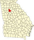
Druid Hills is a community which includes both a census-designated place (CDP) in unincorporated DeKalb County, Georgia, United States, as well as a neighborhood of the city of Atlanta. The CDP's population was 14,568 at the 2010 census. [4] The CDP formerly contained the main campus of Emory University and the Centers for Disease Control and Prevention (CDC) however they were annexed by Atlanta in 2018. The Atlanta-city section of Druid Hills is one of Atlanta's most affluent neighborhoods with a mean household income in excess of $238,500 (making it the ninth most affluent, per that metric). [5]
The planned community was initially conceived by Joel Hurt, and developed with the effort of Atlanta's leading families, including Coca-Cola founder Asa Candler. It contains some of Atlanta's historic mansions from the late 19th and early 20th century. Druid Hills includes the main campus of Emory University, which relocated to Atlanta in 1914.[ citation needed ]
Druid Hills was designed by Frederick Law Olmsted and was one of his last commissions. A showpiece of the design was the string of parks along Ponce de Leon Avenue, which was designated as Druid Hills Parks and Parkways and listed on the National Register of Historic Places on April 11, 1975. The remainder of the development was listed on the Register as the Druid Hills Historic District on October 25, 1979. [6] [7] Later the Park and Parkways district was consolidated into the Druid Hills Historic District. The other historic districts in Druid Hills are:
By 2015 there was a bill in the Georgia Legislature which called for annexing more of Druid Hills into Atlanta. [9]
Druid Hills is located at 33°47′14″N84°19′34″W / 33.78722°N 84.32611°W (33.787205, -84.325974). [10]
According to the United States Census Bureau, the CDP has a total area of 4.2 square miles (11 km2), of which 0.04 square miles (0.10 km2), or 0.48%, is water. The CDP's northern boundary is the South Fork of Peachtree Creek; the CSX track and the Decatur city limits are the eastern boundary; the DeKalb County line is the western boundary; and the southern boundary is the Atlanta city limit.
The Druid Hills neighborhood of Atlanta is bounded by the Druid Hills CDP (i.e. unincorporated DeKalb County) on the north and east; the Morningside/Lenox Park, Virginia-Highland and Poncey-Highland neighborhoods of Atlanta on the west; and the Candler Park neighborhood of Atlanta on the south.[ citation needed ]
The Chelsea Heights neighborhood is located in the eastern part of the CDP at the Decatur border, and participates in the Druid Hills Civic Association.
Census | Pop. | Note | %± |
---|---|---|---|
1980 | 12,700 | — | |
1990 | 12,174 | −4.1% | |
2000 | 12,741 | 4.7% | |
2010 | 14,568 | 14.3% | |
2020 | 9,429 | −35.3% | |
U.S. Decennial Census [11] 1850-1870 [12] 1870-1880 [13] 1890-1910 [14] 1920-1930 [15] 1940 [16] 1950 [17] 1960 [18] 1970 [19] 1980 [20] 1990 [21] 2000 [22] 2010 [23] 2020 [24] |
Druid Hills was first listed as a census designated place in the 1980 U.S. Census. [20]
Race / Ethnicity | Pop 2000 [25] | Pop 2010 [23] | Pop 2020 [24] | % 2000 | % 2010 | % 2020 |
---|---|---|---|---|---|---|
White alone (NH) | 10,511 | 11,103 | 7,112 | 82.50% | 76.21% | 75.43% |
Black or African American alone (NH) | 748 | 1,097 | 554 | 5.87% | 7.53% | 5.88% |
Native American or Alaska Native alone (NH) | 16 | 19 | 9 | 0.13% | 0.13% | 0.10% |
Asian alone (NH) | 929 | 1,594 | 773 | 7.29% | 10.94% | 8.20% |
Pacific Islander alone (NH) | 9 | 6 | 3 | 0.07% | 0.04% | 0.03% |
Some Other Race alone (NH) | 24 | 33 | 50 | 0.19% | 0.23% | 0.53% |
Mixed Race or Multi-Racial (NH) | 195 | 297 | 425 | 1.53% | 2.04% | 4.51% |
Hispanic or Latino (any race) | 309 | 419 | 503 | 2.43% | 2.88% | 5.33% |
Total | 12,741 | 14,568 | 9,429 | 100.00% | 100.00% | 100.00% |
As of the 2020 United States census, there were 9,429 people, 3,579 households, and 1,977 families residing in the CDP.
As of the census [2] of 2000, there were 12,742 people, 4,627 households, and 2,040 families residing in the CDP. The population density was 3,040.4 inhabitants per square mile (1,173.9/km2). There were 4,830 housing units at an average density of 1,152.6 per square mile (445.0/km2). The racial makeup of the CDP was 84.15% White, 6.0% African-American, 0.16% Native American, 7.34% Asian, 0.07% Pacific Islander, 0.64% from other races, and 1.64% from two or more races. Hispanic or Latino of any race were 2.43% of the population.
There were 4,627 households, out of which 18.9% had children under the age of 18 living with them, 37.5% were married couples living together, 4.7% had a female householder with no husband present, and 55.9% were non-families. 37.4% of all households were made up of individuals, and 10.0% had someone living alone who was 65 years of age or older. The average household size was 2.06 and the average family size was 2.80.
In the CDP, the population was spread out, with 13.0% under the age of 18, 30.2% from 18 to 24, 30.7% from 25 to 44, 16.5% from 45 to 64, and 9.6% who were 65 years of age or older. The median age was 28 years. For every 100 females, there were 91.5 males. For every 100 females age 18 and over, there were 88.2 males.
The median income for a household in the CDP was $62,953, and the median income for a family was $106,196. Males had a median income of $57,017 versus $45,458 for females. The per capita income for the CDP was $34,829. About 2.3% of families and 7.7% of the population were below the poverty line, including 3.5% of those under age 18 and 4.2% of those age 65 or over.
Emory University, including its hospitals, is the third largest employer in Metro Atlanta as of 2007/8. [26] The CDC is also an employer of note.
Commercial areas include Emory Village, a small node first developed in the 1920s at the terminus of the streetcar line to Emory. A revitalization of the area was completed in 2011 with new sidewalks, street furniture and two new roundabouts. [27] [28]
The other, larger commercial areas fall just outside the community's boundaries, such as the Clairmont Road corridor in North Decatur, the Sage Hill shopping center in Atlanta's Morningside/Lenox Park, and the Ponce de Leon Avenue corridor just west of Druid Hills in Atlanta's Poncey-Highland/Virginia-Highland.
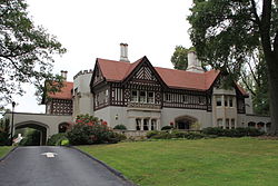
Druid Hills is home to The Atlanta Boy Choir on S. Ponce de Leon Ave. and Callanwolde Fine Arts Center, housed in the Gothic-Tudor style former estate of Charles Howard Candler, president of Coca-Cola and eldest son of Asa Griggs Candler, Coca-Cola's co-founder.
The neighborhood organization, the Druid Hills Civic Association (DHCA), gives input to two authorities since the community is divided between the city of Atlanta and unincorporated territory in DeKalb County.
The Atlanta part is an official recognized neighborhood of Atlanta, which in turn is part of NPU N. Officially, DHCA exercises its input into planning and other city processes by giving input to the NPU. [32]
DeKalb County does not have an officially designated role for the community within the county government in the way the City of Atlanta does (though there are five large geographic districts for the election of county commissioners), so the DHCA gives input to the unitarian county government in Decatur. [33]
The United States Postal Service operates the Druid Hills Post Office at 1799 Briarcliff Road NE in the North Druid Hills CDP in unincorporated DeKalb. [34] [35]
The Centers for Disease Control and Prevention's main offices were formerly located in the CDP. [36] [37] [38] The City of Atlanta annexed the CDC effective January 1, 2018. [39]
Public bus transportation is provided by the Metropolitan Atlanta Rapid Transit Authority, while Emory University runs an extensive fleet of shuttles, called the "Cliff". [40]
Emory University Hospital and Children's Healthcare of Atlanta - Egleston Hospital are in the Druid Hills area.
The City of Atlanta annexed Egleston and Emory University effective January 1, 2018. [41] Prior to the annexation, Egleston was in Druid Hills CDP, as was Emory Hospital. [37] [42] [43]
Druid Hills resides in the DeKalb County School District. [37] Most residents are zoned to Fernbank Elementary School (in the Druid Hills CDP) while some are zoned to Briar Vista Elementary School. [44] All residents are zoned to Druid Hills Middle School (in the North Decatur CDP [45] ), [46] and Druid Hills High School (in the Druid Hills CDP [37] ). [47]
The Paideia School is a nearby preK–12 private school in the city of Atlanta.
Emory University is a private university formerly located in the Druid Hills CDP. [37] [48] The City of Atlanta annexed Emory effective January 1, 2018. [39]
Villa International, a Christian ministry that consists of a two-story 33-room guest house for visiting academics and medical staff from multiple countries, was established in 1972 to provide a welcoming environment in response to the suicide of an African academic in 1966. The initial cost to establish it was $300,000, and by 2020 it gained the nickname "Little U.N." from its guests. [49] The City of Atlanta annexed Villa International effective January 1, 2018. [41] Prior to that date it was in the Druid Hills CDP. [37] [50]
Synagogues are located in adjacent Virginia-Highland, Morningside/Lenox Park and North Druid Hills, the latter having one of the largest concentrations of Orthodox Jews in Metro Atlanta.
DeKalb County is located in the north central portion of the U.S. state of Georgia. As of the 2020 census, the population was 764,382, making it Georgia's fourth-most populous county. Its county seat is Decatur.
Decatur is a city in, and the county seat of, DeKalb County, Georgia, United States, part of the Atlanta metropolitan area. With a population of 24,928 in the 2020 census, the municipality is sometimes assumed to be larger since multiple ZIP Codes in unincorporated DeKalb County bear Decatur as the address. The city is served by three MARTA rail stations. The city is located approximately five miles northeast of Downtown Atlanta and shares its western border with both the city of Atlanta and unincorporated DeKalb County. The Druid Hills neighborhood is to the northwest of Decatur.
North Decatur is an unincorporated community and census-designated place (CDP) in DeKalb County, Georgia, United States. The population was 16,698 at the 2010 census.
North Druid Hills, also known as Briarcliff or Toco Hills, is an unincorporated community and census-designated place in DeKalb County, Georgia, United States. The population was 18,947 at the 2010 census. The commercial center of the area is the Toco Hill Shopping Center, located near the intersection of North Druid Hills Road and LaVista Road.
Scottdale is an unincorporated community and census-designated place (CDP) in DeKalb County, Georgia, United States. The population was 10,631 at the 2010 census.
Tucker is a city located in DeKalb County, Georgia, United States, located near Atlanta and was originally settled in the 1820s, and later developed as a railroad community in 1892. According to the 2016 United States Census Bureau annual estimate of resident population, it has a population of 35,322. In a November 2015 referendum, by a 3:1 margin (73.94%), voters approved incorporating Tucker into a city. In March 2016, Tucker residents elected the city's first mayor and city council.
From its incorporation in 1847, the municipal boundaries of Atlanta, Georgia, United States, were extended repeatedly from a small area around its railroad station to today's city covering 131.7 square miles (341 km2).
Druid Hills Historic District is a historic district in Druid Hills and Atlanta in DeKalb County, Georgia, United States, that is listed on the National Register of Historic Places (NRHP).
Brookhaven is a city in the northeastern suburbs of Atlanta that is located in western DeKalb County, Georgia, United States, directly northeast of Atlanta. On July 31, 2012, Brookhaven was approved in a referendum to become DeKalb County's 11th city. Incorporation officially took place on December 17, 2012, on which date municipal operations commenced. With a population of around 55,366 as of 2021, it is the largest city in DeKalb County. The new city stretches over 12 square miles (31 km2).
Oakhurst is a historic neighborhood in the southwest corner of Decatur, Georgia, a suburb of Atlanta, Georgia. It is located south of downtown Decatur and approximately six miles east of downtown Atlanta. Oakhurst primarily consists of residences built in early 20th century and neighborhood businesses. It is roughly bounded by the City of Atlanta's Kirkwood neighborhood on the west ; the Atlanta city limits on the south; West College Ave. on the north; and South McDonough St. on the east. There is also a neighborhood near the College Heights Early Learning Center referred to as "College Heights", but it is part of Historic Oakhurst.
Avondale is a train station in Decatur, Georgia. It is on the Blue Line of the Metropolitan Atlanta Rapid Transit Authority (MARTA) rail system. The station is at-grade and has two island platforms, one for each direction. The center two tracks are not normally used for through service. Because of these middle tracks, it is not uncommon for trains to be bound for Avondale, having passengers change trains at Avondale. A limited number of Green Line trains originate and terminate at Avondale rather than at their normal terminus at Edgewood / Candler Park, though these trains bypass East Lake and Decatur.
Druid Hills High School is a high school operated by the DeKalb County School District. It is located at 1798 Haygood Drive, in the Druid Hills CDP in unincorporated DeKalb County, Georgia, United States. It serves the Druid Hills CDP, the North Druid Hills CDP, and the North Decatur CDP.
Ponce de Leon Avenue, often simply called Ponce, provides a link between Atlanta, Decatur, Clarkston, and Stone Mountain, Georgia. It was named for Ponce de Leon Springs, in turn from explorer Juan Ponce de León, but is not pronounced as in Spanish. Several grand and historic buildings are located on the avenue.
Clairemont - Great Lakes is a historic neighborhood in the north central section of the Atlanta, Georgia suburb of Decatur. It primarily consists of residences and churches. However, there are businesses on West Ponce de Leon Avenue, in the southernmost section of the neighborhood. Its rough boundaries are Coventry Road, Ponce de Leon Avenue and Commerce Drive on the south; Church Street on the east; Scott Boulevard on the north; and Willow on the northeast. The section of Superior Avenue north of Scott Boulevard is also considered part of this neighborhood. Ridgeland Park, located northeast of the Clairemont - Great Lakes neighborhood, is not presently considered part of the neighborhood. It was developed later (1946–1950) and is in unincorporated DeKalb County. However, in 2008 the city of Decatur began evaluating annexation of this neighborhood, which is contiguous to the rest of the development.
Adair Park is a historic and contemporary community in the west section of the Atlanta, Georgia suburb of Decatur. It is one of Decatur’s most diverse communities in terms of building types, and includes several individual neighborhoods. Adair Park has single family residences, townhomes, cluster homes, institutional buildings and commercial buildings – built from the early 1900s to 2008. Its rough boundaries are: downtown Decatur to the east; Ponce de Leon Avenue to the north; Howard Avenue and the railroad tracks to the south; and the Parkwood neighborhood to the west. There is also an Adair Park in southwest Atlanta, but it is not part of the Decatur community.
Ponce de Leon Heights is a historic neighborhood in the west section Decatur, a suburb of the Atlanta, Georgia, USA. It includes single family residences and a church, primarily built in the early 1900s. The neighborhood is located between Scott Blvd. to the northwest, Ponce de Leon Avenue to the south and Coventry Road to the east. Although the neighborhood partially fronts on Ponce de Leon Avenue, there are no commercial businesses.
Chelsea Heights and Westchester Hills are adjacent neighborhoods, separated by a municipal park, in the northwest corner of the Atlanta, Georgia suburb of Decatur. Chelsea Heights straddles the east and west sides of the CSX railroad tracks, falling within the City of Decatur and the unincorporated DeKalb County, respectively. The latter part, though located east of what historically was Druid Hills, is part of the Druid Hills CDP and participates in the Druid Hills Civic Association: see Chelsea Heights.
Parkwood is a neighborhood on the western side of Decatur, Georgia, a suburb of Atlanta. Although a small portion of the neighborhood was always within the city limits of Decatur, the remainder of the Parkwood neighborhood was voluntarily annexed into the City of Decatur effective July 1, 2014. The neighborhood is bounded by Ponce de Leon Avenue to the north; East Lake Road to the south; the CSX railroad tracks to the west; and Melrose Avenue and the Adair Park community to the east.
The History of Emory University began in 1836 when a small group of Methodists from Newton County contemplated the establishment of a new town and college. The town was called Oxford after the school's prestigious British cousin, which graduated the two founders of Methodism, John and Charles Wesley. The college was named after John Emory, an American Methodist bishop.
Streetcars originally operated in Atlanta downtown and into the surrounding areas from 1871 until the final line's closure in 1949.
Figures are for HQ only, not retail stores.
1405 Clifton Road NE, Atlanta, GA 30322-1062
1364 Clifton Rd NE Atlanta, GA 30322
1749 Clifton Rd. NE, Atlanta, GA 30329 USA