Gillsville, Georgia

Last updated
Gillsville, Georgia
Banks County Georgia Incorporated and Unincorporated areas Gillsville Highlighted.svg
Location in Banks County and the state of Georgia
Coordinates: 34°18′10″N83°37′17″W / 34.30278°N 83.62139°W / 34.30278; -83.62139 Coordinates: 34°18′10″N83°37′17″W / 34.30278°N 83.62139°W / 34.30278; -83.62139
Country United States
State Georgia
Counties Hall, Banks
Area
[1]
  Total1.95 sq mi (5.05 km2)
  Land1.95 sq mi (5.04 km2)
  Water0.00 sq mi (0.00 km2)
Elevation
[2]
925 ft (282 m)
Population
 (2020)
  Total306
  Density157.16/sq mi (60.68/km2)
Time zone UTC-5 (Eastern (EST))
  Summer (DST) UTC-4 (EDT)
ZIP code
30543
Area code 770
FIPS code 13-32860 [3]
GNIS feature ID2403697 [2]
Website gillsvillega.com

Gillsville is a city in Banks and Hall counties in the U.S. state of Georgia. The population was 235 at the 2010 census. [4]

Contents

The Hall County portion of Gillsville is part of the Gainesville, Georgia Metropolitan Statistical Area.

History

The community was named after the local Gills family. [5]

Geography

According to the United States Census Bureau, the city has a total area of 1.1 square miles (2.8 km2), all land.

Demographics

Historical population
CensusPop.Note
1910 216
1920 2254.2%
1930 176−21.8%
1940 157−10.8%
1950 152−3.2%
1960 140−7.9%
1970 100−28.6%
1980 14242.0%
1990 113−20.4%
2000 19572.6%
2010 23520.5%
2020 30630.2%
U.S. Decennial Census [6]

2020 census

Gillsville racial composition [7]
RaceNum.Perc.
White (non-Hispanic)27389.22%
Black or African American (non-Hispanic)41.31%
Native American 41.31%
Asian 30.98%
Other/Mixed 51.63%
Hispanic or Latino 175.56%

As of the 2020 United States census, there were 306 people, 90 households, and 68 families residing in the city.

2000 census

As of the census [3] of 2000, there were 195 people, 79 households, and 57 families residing in the city. The population density was 171.3 inhabitants per square mile (66.1/km2). There were 90 housing units at an average density of 79.1 per square mile (30.5/km2). The racial makeup of the city was 99.49% White, and 0.51% from two or more races. Hispanic or Latino of any race were 1.54% of the population.

There were 79 households, out of which 30.4% had children under the age of 18 living with them, 67.1% were married couples living together, 5.1% had a female householder with no husband present, and 26.6% were non-families. 21.5% of all households were made up of individuals, and 15.2% had someone living alone who was 65 years of age or older. The average household size was 2.47 and the average family size was 2.91.

In the city, the population was spread out, with 20.0% under the age of 18, 7.7% from 18 to 24, 27.2% from 25 to 44, 25.6% from 45 to 64, and 19.5% who were 65 years of age or older. The median age was 42 years. For every 100 females, there were 93.1 males. For every 100 females age 18 and over, there were 90.2 males.

The median income for a household in the city was $51,500, and the median income for a family was $62,750. Males had a median income of $35,417 versus $28,750 for females. The per capita income for the city was $27,551. None of the families and 3.7% of the population were living below the poverty line, including no under eighteens and 7.5% of those over 64.

Education

The portion in Banks County is in the Banks County School District. [8] Students there are zoned to Banks County High School.

The portion in Hall County is in the Hall County School District. [9]

Related Research Articles

<span class="mw-page-title-main">Tift County, Georgia</span> County in Georgia, United States

Tift County is a county located in the south central portion of the U.S. state of Georgia. As of the 2020 census, the population was 41,344. The county seat is Tifton.

<span class="mw-page-title-main">Pike County, Georgia</span> County in Georgia, United States

Pike County is a county located in the west central portion of the U.S. state of Georgia. As of the 2020 census, the population was 18,889. The county seat is Zebulon.

<span class="mw-page-title-main">Newton County, Georgia</span> County in Georgia, United States

Newton County is a county located in the north central portion of the U.S. state of Georgia. As of the 2020 census, the population was 112,483. The county seat is Covington.

<span class="mw-page-title-main">Jackson County, Georgia</span> County in Georgia, United States

Jackson County is a county located in the northeastern part of the U.S. state of Georgia. As of the 2020 census, the population was 75,907. The county seat is Jefferson.

<span class="mw-page-title-main">Hall County, Georgia</span> County in Georgia, United States

Hall County is a county located in the northeast portion of the U.S. state of Georgia. As of the 2020 census, the population was 203,136, up from 179,684 at the 2010 census. The county seat is Gainesville. The entirety of Hall County comprises the Gainesville, Georgia, Metropolitan Statistical Area, which is also part of the Atlanta-Athens-Clarke County-Sandy Springs, Combined Statistical Area.

<span class="mw-page-title-main">Habersham County, Georgia</span> County in Georgia, United States

Habersham County is a county located in the northeastern part of the U.S. state of Georgia. As of the 2020 census, the population was 46,031. The county seat is Clarkesville. The county was created on December 15, 1817, and named for Colonel Joseph Habersham of the Continental Army in the Revolutionary War.

<span class="mw-page-title-main">Franklin County, Georgia</span> County in Georgia, United States

Franklin County is a county located in the northeastern part of the U.S. state of Georgia. As of the 2020 census, the population was 23,424. The county seat is Carnesville. On February 25, 1784, Franklin and Washington became Georgia's eighth and ninth counties, with Franklin named in honor of patriot Benjamin Franklin.

<span class="mw-page-title-main">Colquitt County, Georgia</span> County in Georgia, United States

Colquitt County is a county in the U.S. state of Georgia. As of the 2020 census, the population was 45,898. The county seat is Moultrie. The county was created on February 25, 1856, and is named for Walter Terry Colquitt, a U.S. senator. Colquitt County comprises the Moultrie, GA Micropolitan Statistical Area.

<span class="mw-page-title-main">Banks County, Georgia</span> County in Georgia, United States

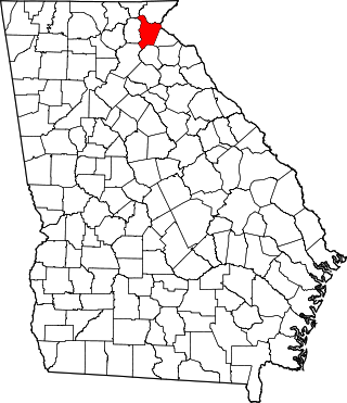
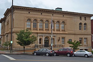
Banks County is a county located in the northeastern part of the U.S. state of Georgia. As of the 2020 census, the population was 18,035, down from 18,395 in 2010. The county seat is Homer. The Old Banks County Courthouse is located in Homer and listed on the National Register of Historic Places. A new county courthouse was constructed adjacent to the old one in 1983.

<span class="mw-page-title-main">Alto, Georgia</span> Town in Georgia, United States

Alto is a town in Banks and Habersham counties in the U.S. state of Georgia. As of the 2010 census, the town had a population of 1,172, up from 876 at the 2000 census.

<span class="mw-page-title-main">Baldwin, Georgia</span> City in Georgia, United States

Baldwin is a city in Banks and Habersham counties in the U.S. state of Georgia. As of the 2010 census, the city had a population of 3,279, up from 2,425 at the 2000 census.
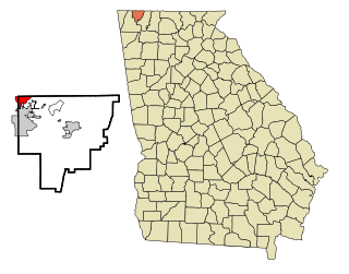
<span class="mw-page-title-main">Lula, Georgia</span> City in Georgia, United States

Lula is a city in Hall and Banks counties in the U.S. state of Georgia. Most of the city is in Hall County, with a small eastern portion of the city located in Banks County. The population was 2,758 at the 2010 census. The Hall County portion of Lula is part of the Gainesville, GA Metropolitan Statistical Area. Lula is the home of RailRoad Days, a yearly festival held usually every May. Lula is the railroad junction between the Atlanta northeast line and the Athens north line of Norfolk Southern Railway.

<span class="mw-page-title-main">Maysville, Georgia</span> Town in Georgia, United States

Maysville is a town in Banks and Jackson counties in the U.S. state of Georgia. The population was 1,798 at the 2010 census, up from 1,247 at the 2000 census.

<span class="mw-page-title-main">Braselton, Georgia</span> Town in Georgia, United States

Braselton is a town in Barrow, Gwinnett, Hall, and Jackson counties in the U.S. state of Georgia, approximately 43 miles (69 km) northeast of Atlanta. As of the 2010 census, the town had a population of 7,511, and in 2018 the estimated population was 11,652.

<span class="mw-page-title-main">Bogart, Georgia</span> Town in Georgia, United States

Bogart is a town in Clarke and Oconee counties in the U.S. state of Georgia. The town is mostly in Oconee County, with a portion extending into Clarke County. As of the 2020 census, the city had a population of 1,326. The 30622 ZIP code extends outside the boundary of Bogart into the western portion of Athens, giving some of Athens' citizens Bogart mailing addresses. For the Oconee County area of Bogart, the high school is North Oconee High School and the middle school is Malcom Bridge Middle School; for the Clarke County area of Bogart, the high school is Clarke Central High School and the middle school is Burney-Harris-Lyons Middle School.

<span class="mw-page-title-main">Rest Haven, Georgia</span> Town in Georgia, United States

Rest Haven is a town primarily in northern Gwinnett and partly in southern Hall counties in the U.S. state of Georgia. As of the 2010 census, it had a total population of 62.

<span class="mw-page-title-main">Meigs, Georgia</span> City in Georgia, United States

Meigs is a city in Thomas County, Georgia, United States, with a small portion extending north into Mitchell County. The population was 928 at the 2020 census, down from 1,035 in 2010.

<span class="mw-page-title-main">Georgetown, Quitman County, Georgia</span> City in Georgia, United States

Georgetown is a city in Quitman County, Georgia, United States. It is on the Alabama-Georgia state line next to Walter F. George Lake and across the Chattahoochee River from Eufaula, Alabama. Per the 2020 census, the population was 2,235. In 2006, Georgetown and Quitman County voted to consolidate their governments, becoming the smallest such consolidated entity in the Lower 48 states.

<span class="mw-page-title-main">Crawfordville, Georgia</span> Town in Georgia, United States

Crawfordville is a town in Taliaferro County, Georgia, United States. The population was 534 at the 2010 census. The city is the county seat of Taliaferro County.

<span class="mw-page-title-main">Varnell, Georgia</span> City in Georgia, United States

Varnell is a city in Whitfield County, Georgia, United States. It is part of the Dalton, Georgia Metropolitan Statistical Area. The population was 2,179 at the 2020 census.

References

  1. "2020 U.S. Gazetteer Files". United States Census Bureau. Retrieved December 18, 2021.
  2. 1 2 U.S. Geological Survey Geographic Names Information System: Gillsville, Georgia
  3. 1 2 "U.S. Census website". United States Census Bureau . Retrieved 2008-01-31.
  4. "Geographic Identifiers: 2010 Demographic Profile Data (G001): Gillsville city, Georgia". U.S. Census Bureau, American Factfinder. Archived from the original on February 12, 2020. Retrieved October 29, 2013.
  5. Krakow, Kenneth K. (1975). Georgia Place-Names: Their History and Origins (PDF). Macon, GA: Winship Press. p. 93. ISBN   0-915430-00-2.
  6. "Census of Population and Housing". Census.gov. Retrieved June 4, 2015.
  7. "Explore Census Data". data.census.gov. Retrieved 2021-12-13.
  8. "2020 CENSUS - SCHOOL DISTRICT REFERENCE MAP: Banks County, GA" (PDF). U.S. Census Bureau . Retrieved 2023-05-07. - Text list
  9. "2020 CENSUS - SCHOOL DISTRICT REFERENCE MAP: Hall County, GA" (PDF). U.S. Census Bureau. p. 9 (PDF p. 10/25). Retrieved 2023-05-07. - Text list