
Quercus montana, the chestnut oak, is a species of oak in the white oak group, Quercus sect. Quercus. It is native to the eastern United States, where it is one of the most important ridgetop trees from southern Maine southwest to central Mississippi, with an outlying northwestern population in southern Michigan. It is also sometimes called "rock oak" because of its presence in montane and other rocky habitats. As a consequence of its dry habitat and ridgetop exposure, it is not usually a large tree, typically 18–22 m (59–72 ft) tall; occasional specimens growing in better conditions can however become large, with trees up to 40–43 m (131–141 ft) tall known. They tend to have a similar spread of 18–22 m (59–72 ft). A 10-year-old sapling grown in full sun will stand about 5 m (16 ft) tall. This species is often an important canopy species in an oak-heath forest.

The pathogenic fungus Cryphonectria parasitica is a member of the Ascomycota taxon. It is the main cause of chestnut blight, a devastating disease of the American chestnut tree that in the early 1900s caused a rapid, widespread die-off of the once plentiful tree from its historic range, in the Eastern United States.

The Appalachian Mountains, often called the Appalachians, are a system of mountains in eastern North America. The Appalachians first formed roughly 480 million years ago during the Ordovician Period. They once reached elevations similar to those of the Alps and the Rocky Mountains before experiencing natural erosion. The Appalachian chain is a barrier to east–west travel, as it forms a series of alternating ridgelines and valleys oriented in opposition to most highways and railroads running east–west.

White County is a county located very near the northeast corner of the U.S. state of Georgia. As of the 2010 census, the population was 27,144. The county seat is Cleveland. The county was created on December 22, 1857 from part of Habersham County and named for Newton County Representative David T. White, who helped a Habersham representative successfully attain passage of an act creating the new county.

Walker County is a county located in the northwestern part of the U.S. state of Georgia. As of the 2010 census, the population was 68,756. The county seat is LaFayette. The county was created on December 18, 1833, from land formerly belonging to the Cherokee Indian Nation.

Union County is a county located in the U.S. state of Georgia. As of the 2010 census, the population was 21,356. The county seat is Blairsville.

Pickens County is a county located in the north central portion of the U.S. state of Georgia. As of the 2010 census, the population was 29,431. The county seat is Jasper.

Lumpkin County is a county located in the north central portion of the U.S. state of Georgia. As of the 2010 census, the population was 29,966. Its county seat is Dahlonega.

Harris County is a county located in the west-central portion of the U.S. state of Georgia; its western border with the state of Alabama is formed by the Chattahoochee River. As of the 2010 census, the population was 32,024. The county seat is Hamilton. The largest city in the county is Pine Mountain, a resort town that is home to the world-famous Callaway Gardens Resort and Franklin D. Roosevelt State Park. Harris County was created on December 14, 1827, and named for Charles Harris, a Georgia judge and attorney.

Habersham County is a county located in the northeast corner of the U.S. state of Georgia. As of the 2010 census, the population was 43,041. The county seat is Clarkesville. The county was created on December 15, 1818, and named for Colonel Joseph Habersham of the Continental Army in the Revolutionary War.

Gordon County is a county located in the northwestern part of the U.S. state of Georgia. As of the 2010 census, the population was 55,186. The county seat is Calhoun.

Cherokee County is a county located in the US state of Georgia. As of the 2010 census, the population was 214,346. According to the local newspaper, the Cherokee Ledger-News on August 29, 2018, with an estimated population of 254,500, Cherokee is currently the fastest growing county in the metro Atlanta, Georgia area. The county seat is Canton. The county Board of Commissioners is the governing body, with members elected to office.
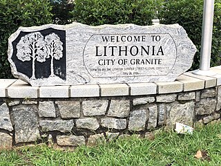
Lithonia is a city in eastern DeKalb County, Georgia, United States. The city's population was 1,924 at the 2010 census. Lithonia is in the Atlanta metropolitan area.

Stone Mountain is a city in DeKalb County, Georgia, United States. The population was 6,368 according to the 2017 US Census estimate. Stone Mountain is located in the eastern part of DeKalb County and is a suburb of Atlanta that encompasses nearly 1.7 square miles. It lies near and touches the western base of the geological formation Stone Mountain. Locals often refer to the city as Stone Mountain Village to distinguish it from the larger unincorporated area traditionally considered Stone Mountain and Stone Mountain Park.

Flowery Branch is a city in Hall County, Georgia, United States. As of the 2010 census, the city had a population of 5,679. It is part of the Gainesville, Georgia metropolitan area, and lies on the shores of Lake Lanier.
The Chestnuts are deciduous tree and shrub species in the genus Castanea. The name also refers to the edible nut these trees produce.

Dick's Knob or Dicks Knob, with an elevation of 4,620 feet (1,408 m), is the third-highest peak in the State of Georgia if using a 200 ft. prominence rule. It is located in Rabun County, Georgia within the Southern Nantahala Wilderness and is the second-highest mountain in the county.
Oak-hickory forest is a type of North American forest ecosystem, and an ecoregion of the Temperate broadleaf and mixed forests Biome.
Chestnut Mountain is a ski resort in Galena, Illinois.
Chestnutflat is an unincorporated community in Walker County, in the U.S. state of Georgia.


