Buckhead Village

Last updated
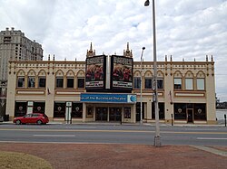
Buckhead Theatre Buckhead Theatre.JPG
Buckhead Theatre
The Storyteller The Storyteller.JPG
The Storyteller
Descriptive plaque of The Storyteller The Storyteller plaque Atlanta.JPG
Descriptive plaque of The Storyteller

Buckhead Village is a neighborhood of Atlanta, Georgia, one of 42 neighborhoods in the larger Buckhead district and the community's historic business section. The Village as defined by the city as the area between Piedmont Road, Peachtree Road, and Pharr Road. [1] [2]

Contents

History

In 1838, Henry Irby purchased 202 1/2 acres surrounding what is now Buckhead Village from Daniel Johnson for $650. Irby subsequently established a general store and tavern at the northwest corner of the Peachtree/Roswell/Paces Ferry intersection. [3] The name "Buckhead" comes from a story that Irby killed a large buck deer and placed the head in a prominent location. [4] Prior to this, the settlement had been called "Irbyville." [5]

The surrounding area, which is now the larger Buckhead community, remained dominated by country estates until after World War I, when many of Atlanta's wealthy began building mansions among the area's rolling hills. The area that is now the Buckhead district was annexed by Atlanta in 1952, following an earlier attempt by Mayor William B. Hartsfield in 1946 that was voted down by residents. [5] In 1956, an estate known as Joyeuse was chosen as the site for a major shopping center to be known as Lenox Square, starting the development of Peachtree Road as a major commercial, financial, and high-rise residential corridor.

To reverse a downturn in the Village during the 1980s, minimum parking spot requirements for bars were lifted, which quickly led to it becoming the most dense concentration of bars and clubs in the city. [6] These establishments included BAR, World Bar, Lulu's Bait Shack, Mako's, Clarence Foster's, Tongue & Groove, Chaos and John Harvard's Brew House. By 1996, Buckhead Village nightlife was comparable to "Mardi Gras, complete with nightly arrests, puking in the streets and [drunk] college girls." [7]

In the late 1990s illegal cruising on Peachtree Road became rampant, making crime harder to spot and the shortage of police officers more apparent. [8] Violent crime increased, culminating with two murders on Super Bowl Sunday in 2000. Baltimore Ravens football player Ray Lewis was implicated in the murders which occurred after he left the Cobalt Club at 265 East Paces Ferry Road. Lewis pleaded guilty to misdemeanor obstructing justice charges and his two co-defendants were found not guilty. [9]

Buckhead Alliance founder Robin Loudermilk claimed that there were at least ten murders during this period related to the nightlife in the Village. [7] Beginning in 2000, residents sought to ameliorate this situation by taking measures to reduce the community's nightlife and re-establish a more residential character. The Buckhead Coalition and councilwoman Mary Norwood were instrumental in persuading the Atlanta City Council to pass an ordinance to close bars at 2:30 a.m., rather than 4 a.m., and liquor licenses were made more difficult to obtain. Eventually, most of the Buckhead Village nightlife area was acquired for the Streets of Buckhead multi-use project and many of the former bars and clubs were torn down in 2007.

Charlie Loudermilk Park

In the triangle formed by Peachtree Road, and Roswell Road, is a pocket park known as Charlie Loudermilk Park, having been renamed from Triangle Park in 2009. Located within the park is The Storyteller, by sculptor Frank Fleming, depicting a man with a buck's head telling a story to various other animals. The descriptive plaque explains:

Local lore has recorded that in 1838 a hunter hung a deer's head at about this location in front of Irby's Tavern. The Henry Irby Family owned 803 surrounding acres and the area was designated Irbyville on maps at that time. People started identifying the area by the buck's head and the community then changed its name to Buckhead... The storyteller is sharing this information with its circle of small animal friends.

Community organizations

The key organizations organizing neighborhoods businesses and residents and working for improvements are the Buckhead Community Improvement District (CID), the Buckhead Area Transportation Management Association (BATMA), the Buckhead Business Association (BBA) and Neighborhood Planning Unit (NPU) B. These organizations backed a new zoning ordinance that the Atlanta City Council adopted on October 4, 2010 that expanded the SPI-9 zoning area from a small area immediately around and southwest of the intersection of Peachtree and Paces Ferry, to cover a much larger commercial area west of Piedmont Ave. and north of Pharr Rd. The stated aim of the community organizations is to create in the Village a "walkable, urban community enriched with public art and parks, wide sidewalks, greenspace, transportation options, and outdoor dining, all designed to have international appeal." [10] As of May 2011, there are plans for a $4 million streetscape program aims to improve the experience for pedestrians in the Village. The program is funded by private donations, CID funding, and a grant from the Woodruff Foundation. While the Streets of Buckhead project went on hold, other developments were moving forward around Peachtree Rd. and Roswell Rd, and so the CID will first improve pedestrian amenities around that area. Completion is targeted for mid-2012. [11]

Shopping

Alice + Olivia, Billy Reid, Bonobos, Christian Louboutin, COS, Dior, Diptyque, Etro, Hermès, jenni kayne, Le Labo, Moncler, Patek Philippe, rag & bone, Theory, Todd Snyder, Warby Parker, and Wolford among others have physical retail spaces in Buckhead Village. [12]

Related Research Articles

<span class="mw-page-title-main">Sandy Springs, Georgia</span> City in Georgia, United States

Sandy Springs is a city in northern Fulton County, Georgia, United States, and a suburb of Atlanta. The city's population was 108,080 at the 2020 census, making it Georgia's 7th most populous city. It is the site of several corporate headquarters, including UPS, Newell Brands, Inspire Brands, Focus Brands, Cox Enterprises, and Mercedes-Benz USA's corporate offices.

<span class="mw-page-title-main">Georgia State Route 400</span> North-south highway in U.S. state of Georgia

Georgia State Route 400 is a freeway and state highway in the U.S. state of Georgia serving parts of Metro Atlanta. It is concurrent with U.S. Route 19 from exit 4 until its northern terminus south-southeast of Dahlonega, linking the city of Atlanta to its north-central suburbs and exurbs. SR 400 travels from the Lindbergh neighborhood in the Buckhead district of Atlanta, at Interstate 85 (I-85), to just south-southeast of Dahlonega. Like the Interstate highways, it is a limited-access road, but unlike the interstates, the exit numbers are not mileage-based, they are sequential. Once SR 400 passes exit 18 (SR 369), it changes from a limited-access freeway into an at-grade divided highway with traffic lights, but still with a high speed limit of 65 miles per hour (105 km/h), and ends at the J. B. Jones Intersection at SR 60/SR 115 in Lumpkin County.

<span class="mw-page-title-main">Peachtree Street</span> Main street of Atlanta, Georgia, USA

Peachtree Street is one of several major streets running through the city of Atlanta, Georgia, United States. Beginning at Five Points in downtown Atlanta, it runs North through Midtown; a few blocks after entering into Buckhead, the name changes to Peachtree Road at Palisades Road. Much of the city's historic and noteworthy architecture is located along the street, and it is often used for annual parades,, as well as one-time parades celebrating events such as the 100th anniversary of Coca-Cola in 1986 and the Atlanta Braves' 1995 and 2021 World Series victories.

<span class="mw-page-title-main">Buckhead</span> District of Atlanta, Georgia, US

Buckhead is the uptown commercial and residential district of the city of Atlanta, Georgia, comprising approximately the northernmost fifth of the city. Buckhead is the third largest business district within the Atlanta city limits, behind Downtown and Midtown, and a major commercial and financial center of the Southern U.S.

The city of Atlanta, Georgia is made up of 243 neighborhoods officially defined by the city. These neighborhoods are a mix of traditional neighborhoods, subdivisions, or groups of subdivisions. The neighborhoods are grouped by the city planning department into 25 neighborhood planning units (NPUs). These NPUs are "citizen advisory councils that make recommendations to the Mayor and City Council on zoning, land use, and other planning issues". There are a variety of other widely recognized named areas within the city. Some are officially designated, while others are more informal.

Standing Peachtree was a Muscogee village and the closest Indian settlement to what is now the Buckhead area of Atlanta, Georgia. It was located where Peachtree Creek flows into the Chattahoochee River, in today's Paces neighborhood. It was located in the borderlands of the Cherokee and Muscogee nations. It is referred to in several documents dating as far back as 1782.

The neighborhood planning unit (NPU) is a community-scale governmental structure used in the City of Atlanta, Georgia.

Historic ferries operated on rivers around Atlanta, Georgia area, and became namesakes for numerous current-day roads in north Georgia. Most of the ferries date to the early years of European-American settlement in the 1820s and 1830s, when parts of the region were still occupied by cherokee and other Native American communities.

Through much of the 19th century, Pace's Ferry was an important ferry across the Chattahoochee River near Atlanta. Started in the early 1830s near Peachtree Creek, it was run by Hardy Pace, one of the city's founders. It was an important transportation link to northwestern Georgia, especially prior to the construction of the State Road to Chattanooga.

<span class="mw-page-title-main">Garden Hills</span> United States historic place

Garden Hills is a neighborhood in the Buckhead section of Atlanta, Georgia between Peachtree and Piedmont Roads, bordered on the north by Pharr Road and on the south by Lindbergh Road. In 1987 the neighborhood was given historic district status by the city of Atlanta.

<span class="mw-page-title-main">Historic Brookhaven</span> United States historic place

Historic Brookhaven is a historic neighborhood, part of which lies in Atlanta's Buckhead Community, part of which lies in Sandy Springs, Georgia, and part of which lies in city of Brookhaven, Georgia, to which it lends its name. Capital City Club country club is at the center of the neighborhood, and it is surrounded by valuable homes, many of which were designed by a number of well-known Atlanta architects of the pre-war period. The neighborhood boundaries are well defined, and it stretches from Peachtree Dunwoody Road to the west, Windsor Parkway to the north, Mabry Drive to the east, and Peachtree Road to the south.

<span class="mw-page-title-main">Buckhead Village District</span> Mixed-use development in Atlanta, Georgia, United States

Buckhead Village District is a 9-acre (3.6 ha) planned mixed-use development in the Buckhead district in Atlanta, Georgia. The project is a redevelopment of part of the Buckhead Village neighborhood bounded by Peachtree Rd., E. Paces Ferry Rd., Pharr Rd., and N. Fulton Drive. It is located just 1.3 miles (2.1 km) from two of the region's most prominent and upscale malls, Lenox Square and Phipps Plaza.

Paces is a neighborhood of Atlanta, US. It is part of the Buckhead district and is located in the far northwest corner of the city. Paces is bounded on the northwest by the Chattahoochee River, which is also the Cobb/Fulton county line. Just across the river in Cobb is the unincorporated community of Vinings, which was originally known as Paces after founder Hardy Pace, who operated Pace's Ferry. Cumberland is also located on the other side of the river. It is perhaps Atlanta's most affluent neighborhood, with many houses selling in the US$5–$7 million range, and some for more than $20 million.

<span class="mw-page-title-main">Pine Hills, Atlanta</span>

Pine Hills is a neighborhood of Atlanta, Georgia and also part of the Buckhead Community, located in north east Atlanta on the eastern part of Buckhead. Many homes in Pine Hills are also located in Brookhaven, GA. It is roughly bounded by Buford Highway to the south, the railway to the north, Lenox Road to the west, and East Roxboro Road to the east. The western and central section of Pine Hills is in Fulton County and a smaller section to the east is in Dekalb County, east of a north-south line that roughly passes through the intersection of East Roxboro Road and West Roxboro Road. The area includes part of the 30324 and 30329 postal zip codes.

Brookwood is a neighborhood at the southernmost tip of the Buckhead Community of Atlanta. It should not be confused with Brookwood Hills, a neighborhood and historic district east of Brookwood across Peachtree Road.

North Buckhead is a neighborhood in the Buckhead district, at the northern edge of the city of Atlanta, Georgia, and is one of Atlanta's most affluent neighborhoods.

<span class="mw-page-title-main">Peachtree Park</span> United States historic place

Peachtree Park is a neighborhood in the Buckhead Community of Atlanta, Georgia.

Buckhead Forest is a neighborhood of 165 homes in the Buckhead district of Atlanta, Georgia.

Argonne Forest is an officially defined neighborhood of Atlanta in the Buckhead area of the city. Its population at the 2010 census was 590. The neighborhood is named after the Argonne Forest in northeastern France, where the American military was heavily involved in the 1918 Meuse-Argonne offensive of World War I.

The PATH400 Greenway Trail is a multi-use trail under construction along the Georgia 400 freeway in Buckhead, Atlanta. Once complete, the trail will be 10 feet to 14 feet wide and traverse the cities of Atlanta, Sandy Springs and Dunwoody.

References

  1. "Buckhead Action Plan" prepared for the Buckhead Action Committee and the Atlanta Regional Commission Archived November 30, 2010, at the Wayback Machine
  2. NPU B Map, City of Atlanta Online Archived 2011-08-13 at the Wayback Machine
  3. Garrett, Franklin M. (1969). Atlanta and environs; a chronicle of its people and events. University of Georgia Press. p. 160.
  4. Watson, Stephanie; Lisa Wojna (2008). Weird, Wacky, and Wild Georgia Trivia. Blue Bike Books. pp. 59, 60. ISBN   978-1-897278-44-4.
  5. 1 2 "Atlanta, Georgia - History, historic". Buckhead. Retrieved 2011-03-29.
  6. "Buckhead Village BAR BRAWL: Critics try to pressure landlords of busy clubs" . Retrieved 6 September 2016.
  7. 1 2 Scott Henry, "Buckhead Rising", Creative Loafing, 2006-05-31
  8. Stephanie Ramage, "The key to saving Buckhead", Creative Loafing, 2000-09-16
  9. "CNNSI.com - 2000 Bloody Monday - Does NFL star Ray Lewis' arrest for murder taint the game? - Friday March 03, 2000 02:02 PM". Archived from the original on 2013-01-26. Retrieved 2013-01-30.
  10. "Buckhead SPI-9 Expansion and Update", Buckhead Community Improvement District Archived July 8, 2011, at the Wayback Machine
  11. "Village Streetscape Program", Buckhead Community Improvement District Archived July 8, 2011, at the Wayback Machine
  12. "Shop All". Buckhead Village District. Jamestown L.P. Retrieved December 5, 2023.

33°50′22″N84°22′48″W / 33.83942°N 84.379869°W / 33.83942; -84.379869