Inman Park

Last updated
Inman Park Historic District [1]
King of Pops.jpg
Welcome Sign in Inman Park
Atlanta Central.png
Red pog.svg
LocationRoughly bounded by Freedom Parkway, DeKalb and Lake Aves. (original) and Roughly bounded by Lake, Hurt, and DeKalb Aves., and Krog St. (increase), Atlanta, Georgia
Coordinates 33°45′20″N84°21′34″W / 33.75556°N 84.35944°W / 33.75556; -84.35944 Coordinates: 33°45′20″N84°21′34″W / 33.75556°N 84.35944°W / 33.75556; -84.35944
Built1889
ArchitectMultiple
Architectural styleQueen Anne, Shingle Style (original); Queen Anne, Stick/Eastlake, Colonial Revival, Shotgun, Bungalow, Arts & Crafts, Romanesque Revival, Prairie Style, Arts & Crafts Revival, et al. (increase)
NRHP reference No. 73000621 and 01000973 [2]
Added to NRHPJuly 23, 1973 (original)
September 16, 2001 (increase)

Inman Park is an intown neighborhood on the east side of Atlanta, Georgia, and its first planned suburb. It was named for Samuel M. Inman.

Contents

History

Today's neighborhood of Inman Park includes areas that were originally designated

The area was part of the battlefield in the Battle of Atlanta in 1864.

Atlanta's first streetcar suburb

Inman Park (proper) was planned in the late 1880s by Joel Hurt, a civil engineer and real-estate developer who intended to create a rural oasis connected to the city by the first of Atlanta's electric streetcar lines, along Edgewood Avenue. The East Atlanta Land Company acquired and developed more than 130 acres east of the city and Hurt named the new suburb for his friend and business associate, Samuel M. Inman. Joseph Forsyth Johnson was hired as landscape designer for Inman Park who included curvilinear street designs and liberal usage of open spaces in his planning. [3] [4] [5]

Phil Haralson home.jpg
Phil Haralson home, 1896
George E. King home.jpg
George Edward King home, 1896

The Atlanta Constitution in 1896 grandly described Inman Park:

High up above the city, where the purest breezes and the brightest sunshine drove away the germs of disease, and where nature had lavished her best gifts, the gentlemen who conceived the thought of Inman Park found the locality above all others which they desired. It was to be a place of homes, of pretty homes, green lawns, and desirable inhabitants. And all save those who would make desirable residents have been excluded. ... It's the prettiest, highest, healthiest and most desirable locality I ever saw. Everybody is friendly and neighborly. ... And as far as accessibility it ranks second to no residence portion of the city. We have three car lines and frequent schedules. [6]

Like new developments throughout the United States at the time, but in stark contrast to the attitudes prevalent in the neighborhood today, Inman Park was conceived of and promoted as a segregated community.

Moreland Park was by contrast developed as a more traditional, incremental building of sub-divisions as opposed to the grand plan for Inman Park proper.

Decline

Sketches of three Inman Park houses, 1895; Ernest Woodruff's house at top; Beath-Dickey House at bottom Inman Park houses 1895.jpg
Sketches of three Inman Park houses, 1895; Ernest Woodruff's house at top; Beath-Dickey House at bottom

The arrival of the automobile allowed upper class Atlantans to live in suburbs farther north from downtown workplaces, such as Morningside and what is now considered Buckhead. Inman Park became less fashionable and the exuberant Victorian architecture came to seem dated. The mansions came to be subdivided into apartments.

Similar to other intown neighborhoods such as Virginia Highland, Inman Park fell to blight during the white middle and upper class exodus to the northern suburbs in the 1950s and 1960s, and was:

an economically depressed neighborhood of mostly blue-collar white folks, elderly couples who could not afford to move out and families on disability and welfare. They lived in rented bungalows or big houses chopped up into tiny roach-infested apartments. [7]

Atlanta's first intown neighborhood to gentrify

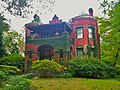
Driving through the neighborhood on his way to appraise stained glass windows in the doomed home of Judge Durwood T. Pye on Poplar Circle, Robert Griggs was smitten by the extraordinary architecture of the Beath-Dickey House, then a dilapidated multi-unit rental property. He and his partner, Robert Aiken, bought the house[ when? ] and restored it to a single-family dwelling. They were followed by others who restored homes; founded[ when? ] Inman Park Restoration, the neighborhood association; and created[ when? ] a neighborhood newsletter, a garden club to rehabilitate public spaces, and a pre-school. [8] To publicize the progress they were making, they began[ when? ] a Tour of Homes with a small festival, which has grown into the hugely popular Inman Park Festival, held each spring.

Freeway revolt against I-485

During this same period, there was an intense fight against the I-485 freeway which was to be built through the neighborhood, although many properties in Inman Park, as well as the entire neighboring neighborhood of Copenhill, were torn down in preparation for freeway construction.

Inman Park today

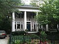
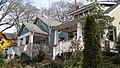
After decades of restoration and renewal, Inman Park is now regarded as a highly desirable intown neighborhood with a mixture of rental and owner-occupied houses and condominiums. Built up as it was over decades, the neighborhood housing now ranges from tiny mill town shotguns to the Victorian mansions of the original development, intermixed with bungalows of all sizes built during the first three decades of the 20th century. Like its housing, the makeup of Inman Park has changed since its inception, with a population that is 25% non-white and of varying economic levels—although increasing housing prices are beginning to force more economic homogeneity. [9] Since the beginning of its renewal, inclusivity and a strong sense of community have distinguished Inman Park. The neighborhood association has always welcomed renters and homeowners alike, with nominal annual dues, while the Inman Park Festival, which attracts tens of thousands of visitors every spring, brings residents together to produce the largest all-volunteer festival in Georgia. The Festival's centerpiece is the Tour of Homes, which showcases the wide variety of sizes and types of residences in the neighborhood.

Former industrial areas on the west side of the neighborhood have been redeveloped into mixed-use complexes. The former General Pipe and Foundry site is now North Highland Steel and the Mead paper plant site is now Inman Park Village. In the early 1990s the former Atlanta Stove Works was transformed by swapping out two letters of its name and became the Atlanta Stage Works, a film and media production center that eventually housed the early Tyler Perry film studios and the National AIDS Quilt. In 2015 it was converted into a mixed-use office and restaurant space, to be added to the space across Krog Street to form the Krog Street Market.

Geography

Inman Park is bordered by: [10]

Little Five Points district is located where Inman Park and Candler Park meet at Moreland Avenue and Euclid/McClendon. [10]

Architecture

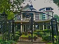
Inman Park contains Atlanta's best collection of residential architecture from the late 19th and early 20th centuries. Styles include Queen Anne, high-style Italianate and Romanesque mansion as well as smaller bungalows, shotguns, and foursquares. Inman Park was Atlanta's first example of a garden suburb, with great attention paid to street layout, parks and other public space, and would inspire other Atlanta garden suburbs such as the Frederick Law Olmsted-designed Druid Hills.

There are two historic districts within the Inman Park neighborhoods: the Inman Park historic district, and the Inman Park-Moreland Historic District, originally the separate suburb of Moreland Park. [11]

Notable houses include:

Other points of interest

Parks

Parks in Inman Park include Springvale Park, a pet project of Joel Hurt and designed by the Olmsted Brothers. [12] Part of Freedom Park lies in the neighborhood, which the BeltLine trail also borders. There are also smaller parks: Delta Park, Inman Park, the park in Inman Park Village, and the Bass Recreation Center.

Government

Inman Park is in NPU N. Neighbors participate in the Inman Park Neighborhood Association (IPNA). [13]

Education

Inman Park residents are served by Atlanta Public Schools.

Zoned schools include:

Transportation

MARTA runs bus service and rail service. The Inman Park / Reynoldstown MARTA station is located at the south end of the neighborhood.

Related Research Articles

<span class="mw-page-title-main">Little Five Points</span> Commercial district on the east side of Atlanta, Georgia, United States

Little Five Points is a district on the east side of Atlanta, Georgia, United States, 2+12 miles (4.0 km) east of downtown. It was established in the early 20th century as the commercial district for the adjacent Inman Park and Candler Park neighborhoods, and has since become famous for the alternative culture it brings to Atlanta. It has been described as Atlanta's version of Haight-Ashbury, a melting pot of sub-cultures, and the bohemian center of the Southern United States.

<span class="mw-page-title-main">Poncey–Highland</span> Neighborhoods of Atlanta in Fulton County, Georgia, United States

Poncey–Highland is an intown neighborhood on the east side of Atlanta, Georgia, located south of Virginia–Highland. It is so named because it is near the intersection of east/west Ponce de Leon Avenue and north/southwest North Highland Avenue. This Atlanta neighborhood was established between 1905 and 1930, and is bordered by Druid Hills and Candler Park across Moreland Avenue to the east, the Old Fourth Ward across the BeltLine Eastside Trail to the west, Inman Park across the eastern branch of Freedom Parkway to the south, and Virginia Highland to the north across Ponce de Leon Avenue. The Little Five Points area sits on the border of Poncey–Highland, Inman Park, and Candler Park.

<span class="mw-page-title-main">Virginia–Highland</span> Neighborhoods of Atlanta in Fulton County, Georgia, United States

Virginia–Highland is an affluent neighborhood of Atlanta, Georgia, founded in the early 20th century as a streetcar suburb. It is named after the intersection of Virginia Avenue and North Highland Avenue, the heart of its trendy retail district at the center of the neighborhood. The neighborhood is famous for its bungalows and other historic houses from the 1910s to the 1930s. It has become a destination for people across Atlanta with its eclectic mix of restaurants, bars, and shops as well as for the Summerfest festival, annual Tour of Homes and other events.

<span class="mw-page-title-main">Cabbagetown, Atlanta</span> United States historic place

Cabbagetown is an intown neighborhood on the east side of Atlanta, Georgia, United States, abutting historic Oakland Cemetery. It includes the Cabbagetown District, a historic district listed on the U.S. National Register of Historic Places.

<span class="mw-page-title-main">Reynoldstown, Atlanta</span> United States historic place

Reynoldstown is a historic district and intown neighborhood on the near east side of Atlanta, Georgia, located two miles from downtown. The neighborhood is gentrifying and attracting new families, empty-nesters, Atlantans opposed to long commutes; as well as diverse culture of first-time homebuyers, single professionals, artist and students due to its close proximity to other nearby intown neighborhoods, high walkability index, urban amenities and nearby bohemian hotspots on Carroll Street in the adjoined-at-the-hip also historic Cabbagetown neighborhood and in other surrounding communities.

<span class="mw-page-title-main">Inman Park/Reynoldstown station</span> MARTA rail station

Inman Park / Reynoldstown is a train station in Atlanta, Georgia, serving the Blue Line of the Metropolitan Atlanta Rapid Transit Authority (MARTA) rail system. It also serves the Green Line on weekdays, and has two side platforms and two tracks. This station opened June 30, 1979.

<span class="mw-page-title-main">Freedom Park (Atlanta, Georgia)</span>

Freedom Park is one of the largest city parks in Atlanta, Georgia, United States. The park forms a cross shape with the axes crossing at the Carter Center. The park stretches west-east from Parkway Drive, just west of Boulevard, to the intersection with the north-south BeltLine Eastside Trail, to Candler Park, and north-south from Ponce de Leon Avenue to the Inman Park/Reynoldstown MARTA station.

Edgewood is a neighborhood located on the east side of Atlanta, Georgia, United States, located approximately 3 miles (4.8 km) east of downtown Atlanta.

<span class="mw-page-title-main">Old Fourth Ward</span> Neighborhoods of Atlanta in Fulton County, Georgia, United States

The Old Fourth Ward, often abbreviated O4W, is an intown neighborhood on the eastside of Atlanta, Georgia, United States. The neighborhood is best known as the location of the Martin Luther King Jr. historic site.

<span class="mw-page-title-main">Westview, Atlanta</span> CDP in Georgia, United States

Westview is a historic intown neighborhood located in southwest Atlanta, Georgia. It is named for the Westview Cemetery that borders the neighborhood to the northwest. The neighborhood is made up of a mixture of architectural styles including Arts & Crafts bungalows, Four-Squares, Tudors, Minimal Traditional houses, and Ranch style houses.

<span class="mw-page-title-main">Ponce de Leon Avenue</span> Road in Georgia, USA

Ponce de Leon Avenue, often simply called Ponce, provides a link between Atlanta, Decatur, Clarkston, and Stone Mountain, Georgia. It was named for Ponce de Leon Springs, in turn from explorer Juan Ponce de León, but is not pronounced as in Spanish. Several grand and historic buildings are located on the avenue.

<span class="mw-page-title-main">Copenhill</span> Neighborhood of Atlanta, Georgia

Copenhill, Copenhill Park, or Copen Hill was a neighborhood of Atlanta, Georgia which was located largely where the Carter Center now sits, and which now forms part of the Poncey-Highland neighborhood.

<span class="mw-page-title-main">Beath–Dickey House</span> Historic site in Atlanta, GA

The Beath–Dickey House (1890) is a Queen Anne Victorian house located at 866 Euclid Avenue in the Inman Park neighborhood of Atlanta, Georgia. It was one of the houses of note when the Inman Park – Atlanta's first streetcar suburb – was established.

<span class="mw-page-title-main">Atlanta freeway revolts</span>

There have been multiple freeway revolts in Atlanta, Georgia. The longest and most famous examples of Interstate opposition were against I-485 and the Stone Mountain Freeway through Intown Atlanta, lasting over 30 years, from the early 1960s until the final construction of Freedom Parkway on a small portion of the contested routes in 1994.

<span class="mw-page-title-main">Willis F. Denny</span> American architect

Willis F. Denny (1874-1905) was an architect active in Atlanta, Georgia around the turn of the twentieth century. He was the architect of Rhodes Hall (1903) and the Kriegshaber House, both listed on the National Register, as well as the demolished Piedmont Hotel (1903).

<span class="mw-page-title-main">Gentrification of Atlanta</span>

Gentrification of Atlanta's inner-city neighborhoods began in the 1970s, and it has continued, at varying levels of intensity, into the present. Many factors have contributed to the city's gentrification. A major increase in gentrification that occurred in the last years of the twentieth century has been attributed to the 1996 Summer Olympics. However, during the 2000s, Atlanta underwent a profound transformation demographically, physically, and culturally. Suburbanization, rising prices, a booming economy, and new migrants decreased the city’s black percentage from a high of 67% in 1990 to 54% in 2010. From 2000 to 2010, Atlanta gained 22,763 white residents, 5,142 Asian residents, and 3,095 Hispanic residents, while the city’s black population decreased by 31,678. Much of the city’s demographic change during the decade was driven by young, college-educated professionals: from 2000 to 2009, the three-mile radius surrounding Downtown Atlanta gained 9,722 residents aged 25 to 34 holding at least a four-year degree, an increase of 61%. Between the mid-1990s and 2010, stimulated by funding from the HOPE VI program, Atlanta demolished nearly all of its public housing, a total of 17,000 units and about 10% of all housing units in the city. In 2005, the $2.8 billion BeltLine project was adopted, with the stated goals of converting a disused 22-mile freight railroad loop that surrounds the central city into an art-filled multi-use trail and increasing the city’s park space by 40%. Lastly, Atlanta’s cultural offerings expanded during the 2000s: the High Museum of Art doubled in size; the Alliance Theatre won a Tony Award; and numerous art galleries were established on the once-industrial Westside.

The History of Virginia–Highland, the Intown Atlanta neighborhood, dates back to 1812, when William Zachary bought and built a farm on 202.5 acres (0.819 km2) of land there. At some point between 1888 and 1890 the Nine-Mile Circle streetcar arrived,, making a loop of what are now Ponce de Leon Avenue, North Highland Avenue, Virginia Avenue, and Monroe Drive. Atlantans at first used the line to visit what was then countryside, including Ponce de Leon Springs, but the line also enabled later development in the area. Residential development began as early as 1893 on St. Charles and Greenwood Avenues, must most development took place from 1909 through 1926 — solidly upper-middle class neighborhoods, kept all-white by covenant.

The Virginia–Highland Tour of Homes is an annual two-day event that happens each December in the Virginia–Highland neighborhood of Atlanta. During the event, houses around the neighborhood are open to visitors. The Virginia–Highland Civic Association organizes the event.

<span class="mw-page-title-main">Highland Avenue (Atlanta)</span>

Highland Avenue, east of the BeltLine North Highland Avenue, is a major thoroughfare in northeast Atlanta, forming a major business corridor connecting five Intown neighborhoods:

<span class="mw-page-title-main">Eastside, Atlanta</span> City district of Atlanta, Georgia

Eastside refers to the city district comprising the easternmost portion of Atlanta, Georgia, United States. The Eastside generally encompasses the area bounded on the west by Midtown Atlanta and Downtown Atlanta and on the east by the city limits. The central corridor of the district is the BeltLine Eastside Trail, which connects northern Eastside neighborhoods with those to the south. The Eastside is known for its nightlife establishments, craftsman architecture, local eateries, and quirky public art.

References

  1. The original NRHP listing was as "Inman Park" but the boundary increase renamed it to "Inman Park Historic District" in the NRHP.
  2. "National Register Information System". National Register of Historic Places . National Park Service. March 13, 2009.
  3. Bazemore, Ted (September 12, 2007). "Inman Park". The New Georgia Encyclopedia. Archived from the original on 1 February 2013. Retrieved 27 December 2010.
  4. "Bruce Forsyth". Who do you think you are?. BBC. Retrieved 28 December 2010.
  5. Joseph Forsyth Johnson was the author of The Natural Principles of Landscape Gardening; or, The adornment of land for perpetual beauty. Belfast: Archer, 1874
  6. "Homes at the Park: Beautiful residences that make Inman Park an ideal home place", Atlanta Constitution, 1896-03-26
  7. Communications, Emmis (1 October 2005). "Atlanta Magazine". Emmis Communications. Retrieved 16 April 2018 via Google Books.
  8. Marr, Christine V.; Jones, Sharon Foster (2008). Inman Park. Charleston, S.C.: Arcadia Pub. p. 101. ISBN   978-0-7385-6731-0.
  9. "Race and Ethnicity in Atlanta-Inman Park, Atlanta, Georgia (Neighborhood)". Statisticalatlas.com. Retrieved 26 August 2015.
  10. 1 2 Google Maps
  11. "Inman Park--Moreland Historic District--Atlanta: A National Register of Historic Places Travel Itinerary". Nps.gov. Retrieved 16 April 2018.
  12. "Parks", Inman Park association website Archived 2014-08-21 at the Wayback Machine
  13. Inman Park Neighbors Association site Archived 2014-08-21 at the Wayback Machine