Eastside, Atlanta

Last updated

The entrance of Ponce City Market, a large mixed-use development. Ponce City Market large neon sign Midtown, Atlanta, GA.jpg
The entrance of Ponce City Market, a large mixed-use development.
Public art on the Eastside Urban art Atlanta.jpg
Public art on the Eastside
The Vortex restaurant, Little Five Points The Vortex!.jpg
The Vortex restaurant, Little Five Points

Eastside refers to the city district comprising the easternmost portion of Atlanta, Georgia, United States. The Eastside generally encompasses the area bounded on the west by Midtown Atlanta and Downtown Atlanta and on the east by the city limits. The central corridor of the district is the BeltLine Eastside Trail, which connects northern Eastside neighborhoods with those to the south. The Eastside is known for its nightlife establishments, craftsman architecture, local eateries, and quirky public art. [1]

Contents

History

The area that is now the Eastside was the site of the Battle of Atlanta, which was part of the Atlanta Campaign and sealed the fate of the Confederacy. Indeed, Lemuel P. Grant designed the city's fortifications to protect his plantation on what is now the Eastside neighborhood of Grant Park. General James B. McPherson placed his Yankee forces on high ground a mile east of Grant's plantation, in the neighborhood today known as East Atlanta.

Beginning in the 1890s, streetcar suburbs were constructed on the Eastside as havens for the upper middle class. These neighborhoods, many of which contained their own villages encircled by shaded, architecturally distinct residential streets, include the Victorian Inman Park, Bohemian East Atlanta, and eclectic Old Fourth Ward. [1] Some Eastside neighborhoods, including Kirkwood and Edgewood, were separate municipalities before annexation by Atlanta in 1909 and 1915. By mid-century, the Eastside began to succumb to the effects of urban decay and white flight, with Virginia-Highland remaining a notable exception to the area's decline. While the area suffered during the 1970s and 1980s nadir of Atlanta's depopulation, much of its historic architecture remained intact.

In 1990, when Atlanta's intown resurgence began in earnest, the Eastside served as the starting point for the city's gentrification wave. Indeed, while rising property values in the 1990s displaced older, long-term residents as middle- and upper-income residents across the city, in few areas were these increases as dramatic as in the enclave of neighborhoods on the Eastside of Atlanta. Due to the close proximity to downtown, an ample stock of historic housing, and distinct commercial villages, property values on the Eastside skyrocketed. In Kirkwood, for example, median sales prices soared 275% from 1993 to 2003. [2]

The initialization of the BeltLine project in 2005 sent the area's revitalization into overdrive. [3] During the 2000s, more than $775 million in private investment was pumped into the half-mile radius surrounding the Eastside Trail, including a $180 million transformation of a former Sears warehouse into Ponce City Market. [4]

With the dawn of the 21st century, many former industrial buildings bordering the trail were repurposed for residential and retail use. Examples are Ponce City Market, Krog Street Market, Telephone Factory Lofts and many others particularly in the Old Fourth Ward, Inman Park Village, and Kirkwood.

Neighborhoods

Bungalows on Atlanta's Eastside Atlanta etc. 019.jpg
Bungalows on Atlanta's Eastside
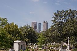
Oakland Cemetery Oakland Cemetery and Atlanta Skyscrapers.jpg
Oakland Cemetery

Little Five Points is a commercial district located where Inman Park and Candler Park meet. Scottdale a census designated place on the east side of Atlanta

Related Research Articles

<span class="mw-page-title-main">Inman Park</span> Historic district on the east side of Atlanta, Georgia, United States

Inman Park is an intown neighborhood on the east side of Atlanta, Georgia, and its first planned suburb. It was named for Samuel M. Inman.

The Atlanta BeltLine is a 22 miles (35 km) open and planned loop of multi-use trail and light rail transit system on a former railway corridor around the core of Atlanta, Georgia. The Atlanta BeltLine is designed to reconnect neighborhoods and communities historically divided and marginalized by infrastructure, improve transportation, add green space, promote redevelopment, create and preserve affordable housing, and showcase arts and culture. The project is in varying stages of development, with several mainline and spur trails complete and others in an unpaved, but hikeable, state. Since the passage of the More MARTA sales tax in 2016, construction of the light rail streetcar system is overseen by MARTA in close partnership with Atlanta BeltLine, Inc.

<span class="mw-page-title-main">Poncey–Highland</span> Neighborhoods of Atlanta in Fulton County, Georgia, United States

Poncey–Highland is an intown neighborhood on the east side of Atlanta, Georgia, located south of Virginia–Highland. It is so named because it is near the intersection of east/west Ponce de Leon Avenue and north/southwest North Highland Avenue. This Atlanta neighborhood was established between 1905 and 1930, and is bordered by Druid Hills and Candler Park across Moreland Avenue to the east, the Old Fourth Ward across the BeltLine Eastside Trail to the west, Inman Park across the eastern branch of Freedom Parkway to the south, and Virginia Highland to the north across Ponce de Leon Avenue. The Little Five Points area sits on the border of Poncey–Highland, Inman Park, and Candler Park.

<span class="mw-page-title-main">Virginia–Highland</span> Neighborhoods of Atlanta in Fulton County, Georgia, United States

Virginia–Highland is an affluent neighborhood of Atlanta, Georgia, founded in the early 20th century as a streetcar suburb. It is named after the intersection of Virginia Avenue and North Highland Avenue, the heart of its trendy retail district at the center of the neighborhood. The neighborhood is famous for its bungalows and other historic houses from the 1910s to the 1930s. It has become a destination for people across Atlanta with its eclectic mix of restaurants, bars, and shops as well as for the Summerfest festival, annual Tour of Homes and other events.

<span class="mw-page-title-main">Reynoldstown, Atlanta</span> United States historic place

Reynoldstown is a historic district and intown neighborhood on the near east side of Atlanta, Georgia, located two miles from downtown. The neighborhood is gentrifying and attracting new families, empty-nesters, Atlantans opposed to long commutes; as well as diverse culture of first-time homebuyers, single professionals, artist and students due to its close proximity to other nearby intown neighborhoods, high walkability index, urban amenities and nearby bohemian hotspots on Carroll Street in the adjoined-at-the-hip also historic Cabbagetown neighborhood and in other surrounding communities.

<span class="mw-page-title-main">Edgewood/Candler Park station</span> MARTA rail station

Edgewood / Candler Park is a train station in Atlanta, Georgia, on the Blue Line of the Metropolitan Atlanta Rapid Transit Authority (MARTA) rail system. Currently, the station also serves as the terminus of the Green Line on weekdays. On weekends, Green Line service instead terminates two stops to the west at King Memorial. The station opened on June 30, 1979.

<span class="mw-page-title-main">Freedom Park (Atlanta, Georgia)</span>

Freedom Park is one of the largest city parks in Atlanta, Georgia, United States. The park forms a cross shape with the axes crossing at the Carter Center. The park stretches west-east from Parkway Drive, just west of Boulevard, to the intersection with the north-south BeltLine Eastside Trail, to Candler Park, and north-south from Ponce de Leon Avenue to the Inman Park/Reynoldstown MARTA station.

Edgewood is a neighborhood located on the east side of Atlanta, Georgia, United States, located approximately 3 miles (4.8 km) east of downtown Atlanta.

<span class="mw-page-title-main">Old Fourth Ward</span> Neighborhoods of Atlanta in Fulton County, Georgia, United States

The Old Fourth Ward, often abbreviated O4W, is an intown neighborhood on the eastside of Atlanta, Georgia, United States. The neighborhood is best known as the location of the Martin Luther King Jr. historic site.

<span class="mw-page-title-main">Ponce de Leon Avenue</span> Road in Georgia, USA

Ponce de Leon Avenue, often simply called Ponce, provides a link between Atlanta, Decatur, Clarkston, and Stone Mountain, Georgia. It was named for Ponce de Leon Springs, in turn from explorer Juan Ponce de León, but is not pronounced as in Spanish. Several grand and historic buildings are located on the avenue.

<span class="mw-page-title-main">Ponce City Market</span> Mixed-use development in Georgia, United States

Ponce City Market is a mixed-use development located in a former Sears catalogue facility in Atlanta, with national and local retail anchors, restaurants, a food hall, boutiques and offices, and residential units. It is located adjacent to the intersection of the BeltLine with Ponce de Leon Avenue in the Old Fourth Ward near Virginia Highland, Poncey-Highland and Midtown neighborhoods. The 2.1-million-square-foot (200,000 m2) building, one of the largest by volume in the Southeast United States, was used by Sears, Roebuck and Co. from 1926–1987 and later by the City of Atlanta as "City Hall East". The building's lot covers 16 acres (65,000 m2). Ponce City Market officially opened on August 25, 2014. It was listed on the National Register of Historic Places in 2016.

<span class="mw-page-title-main">Nine-Mile Circle</span>

The Nine-Mile Circle was a streetcar line of the Atlanta Street Railway, later the Atlanta Consolidated Street Railway which went from downtown Atlanta to today's Virginia-Highland neighborhood as follows:

<span class="mw-page-title-main">Streetcars in Atlanta</span> Aspect of the history of Atlanta, Georgia, USA

Streetcars originally operated in Atlanta downtown and into the surrounding areas from 1871 until the final line's closure in 1949.

<span class="mw-page-title-main">Historic Fourth Ward Park</span>

Historic Fourth Ward Park is a park built on the site of the old Ponce de Leon amusement park, in the Old Fourth Ward of Atlanta, just south of Ponce City Market and just west of the BeltLine Eastside Trail.

<span class="mw-page-title-main">Gentrification of Atlanta</span>

Gentrification of Atlanta's inner-city neighborhoods began in the 1970s, and it has continued, at varying levels of intensity, into the present. Many factors have contributed to the city's gentrification. A major increase in gentrification that occurred in the last years of the twentieth century has been attributed to the 1996 Summer Olympics. However, during the 2000s, Atlanta underwent a profound transformation demographically, physically, and culturally. Suburbanization, rising prices, a booming economy, and new migrants decreased the city’s black percentage from a high of 67% in 1990 to 54% in 2010. From 2000 to 2010, Atlanta gained 22,763 white residents, 5,142 Asian residents, and 3,095 Hispanic residents, while the city’s black population decreased by 31,678. Much of the city’s demographic change during the decade was driven by young, college-educated professionals: from 2000 to 2009, the three-mile radius surrounding Downtown Atlanta gained 9,722 residents aged 25 to 34 holding at least a four-year degree, an increase of 61%. Between the mid-1990s and 2010, stimulated by funding from the HOPE VI program, Atlanta demolished nearly all of its public housing, a total of 17,000 units and about 10% of all housing units in the city. In 2005, the $2.8 billion BeltLine project was adopted, with the stated goals of converting a disused 22-mile freight railroad loop that surrounds the central city into an art-filled multi-use trail and increasing the city’s park space by 40%. Lastly, Atlanta’s cultural offerings expanded during the 2000s: the High Museum of Art doubled in size; the Alliance Theatre won a Tony Award; and numerous art galleries were established on the once-industrial Westside.

The History of Virginia–Highland, the Intown Atlanta neighborhood, dates back to 1812, when William Zachary bought and built a farm on 202.5 acres (0.819 km2) of land there. At some point between 1888 and 1890 the Nine-Mile Circle streetcar arrived,, making a loop of what are now Ponce de Leon Avenue, North Highland Avenue, Virginia Avenue, and Monroe Drive. Atlantans at first used the line to visit what was then countryside, including Ponce de Leon Springs, but the line also enabled later development in the area. Residential development began as early as 1893 on St. Charles and Greenwood Avenues, must most development took place from 1909 through 1926 — solidly upper-middle class neighborhoods, kept all-white by covenant.

<span class="mw-page-title-main">Highland Avenue (Atlanta)</span>

Highland Avenue, east of the BeltLine North Highland Avenue, is a major thoroughfare in northeast Atlanta, forming a major business corridor connecting five Intown neighborhoods:

<span class="mw-page-title-main">Edgewood Avenue</span> Street in Atlanta, Georgia, United States

Edgewood Avenue is a street in Atlanta, Georgia, United States which runs from Five Points in Downtown Atlanta, eastward through the Old Fourth Ward. The avenue runs in the direction of the Edgewood neighborhood, and stops just short of it in Inman Park. Edgewood Avenue was first important as the route of a streetcar line to Inman Park, Atlanta's first garden suburb and home to many of its most prominent citizens. Today, the avenue is known for its restaurants and nightlife around its intersection with Boulevard.

The Eastside Trail is a walking and biking trail stretching northwest to southeast on the Eastside of Atlanta, part of the BeltLine ring of trails and parks. It is lined with numerous notable industrial buildings adapted into restaurants, shops, apartments, condos, and two major food halls and mixed-use developments.

References

  1. 1 2 Greenfield, Beth (May 29, 2005). "SURFACING - EAST ATLANTA - The Signs of Chic Are Emerging - NYTimes.com". New York Times. Atlanta (Ga); Georgia. Retrieved October 16, 2012.
  2. The Double-edged Sword of Gentrification in Atlanta
  3. www.atlantaintownpaper.com https://web.archive.org/web/20120304195238/http://www.atlantaintownpaper.com/issue2/index.php?issue=2008_06. Archived from the original on March 4, 2012.{{cite web}}: Missing or empty |title= (help)
  4. Atlanta's Eastside comes alive! | News Feature | Creative Loafing Atlanta