Capitol View Manor

Last updated
Capitol View Manor banner.jpg

Capitol View Manor is a small community in Southwest Atlanta that was named for the excellent view of the Georgia State Capitol building. Its boundaries include I-75/85 to the east, the Beltline to the north, Metropolitan Parkway to the west, and Atlanta Technical College to the south.

Contents

History

Early history

Capitol View Manor was originally vast farmland owned by a select group of people that included John Shannon and the Deckner Family. During the early 1910s, many people started to settle in the area, and, in 1912, the area known as Capitol View was annexed to the City of Atlanta. This is when many utilities, including sewage and electricity, came to the area. In 1920, Capitol View Manor was established, and more houses started to be built on the eastern side of Stewart Avenue. Five years later, Capitol View Manor was annexed to the City of Atlanta. Most of the homes in this neighborhood were built in the next twenty years. In addition, the Capitol View School was built in 1929.

Decline

Former Capitol View Baptist Church Capitol View Baptist Church.JPG
Former Capitol View Baptist Church

During the mid-20th century, Interstate 75-85 cut through the land to the east of the neighborhood, separating Capitol View Manor to what is now known as High Pointe Estates, cutting Manford Road in two pieces, and destroying the intersection of Hillside and Deckner in the southeast corner of the neighborhood. In this timeframe, "white flight" occurred in the neighborhood. Few stayed, and the neighborhood fell into decline.

Renewal

In the late 1990s Stewart Avenue was renamed Metropolitan Parkway so the street wouldn't be referred to as a red-light district. Since then, many efforts have been made to revive the area: more retail is coming to the area, the Beltline Tax Allocation District, and home sales are rising. The Pittsburgh Yards project located across the Southside Beltline trail from CVM also promises to be an economic catalyst for the area bringing new jobs, opportunities for small businesses, community engagement, and green space.

Housing

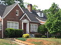
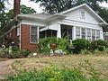
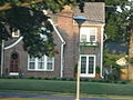
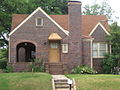
Most of the homes in Capitol View Manor were built between the early 1920s and the mid-1940s. Earlier home styles include Bungalows, Victorians, Cape Cods, and Colonials. Most of the later homes were ranches. Capitol View Manor was originally developed by the same developer of the Morningside and Virginia Highland neighborhood. The rolling streets are a calming contrast to the street-car grid neighborhoods neighboring CVM. As of 2023, homes in the neighborhood are some of the most affordable within the city limits for their location, uniqueness and quality; they range from $300,000 - $600,000. [1]

Parks and recreation

Dill Triangle Park Image-Dill Triangle Park.jpg
Dill Triangle Park
Emma Millican Park prior to Renovation Emma Millican Park.jpeg
Emma Millican Park prior to Renovation

Capitol View Manor is close to many recreational amenities, including the 10-acre (40,000 m2) Millican Park, the 50-acre (200,000 m2) Perkerson Park, the 28-acre (110,000 m2) Hillside Park, and the Carver Family YMCA.

Emma Millican Park is the largest available greenspace in the neighborhood. It is at the western stub of Deckner Ave. and offers a playground, shaded walking trails, a pavilion, open green-space and creek. In 2005, Emma Millican Park was chosen to undergo the Park Pride Visioning Process, in which the neighbors of the community came up with a master plan for their neighborhood park. In addition, the Dill Triangle Park is often used as a garden and a gathering place and is decorated for the holidays every December by the neighborhood association.

Landmarks

Postal Union Building Capitol View masonic Lodge.jpg
Postal Union Building

Capitol View Manor is home to Liberty International Church and the former 80-year-old Capitol View Baptist Church was demolished in 2014 to make way for the Metropolitan Branch Library. Attempts to remodel the church as the new library were cost prohibitive but neighbors were able to get the marble columns and stained glass windows saved to be repurposed at the new library. The 102-year-old Deckner house (which was the residence of the Deckner Family), Fire Station 20, Advance Auto Parts, and the yellow-brick Postal Union building are also neighborhood landmarks. The Southside trail of the Beltline also spans the entire northern boundary along Erin Ave.

Education

Former Capitol View Elementary School Capitol View Elementary School (Atlanta).jpeg
Former Capitol View Elementary School

The schools for the neighborhood are:

In addition, the Atlanta Technical College and the Atlanta Metropolitan College are due south of the neighborhood.

Metropolitan Library

The Atlanta–Fulton Public Library System opened the Metropolitan Branch Library located at 1332 Metropolitan Parkway, Atlanta, GA 30310 on October 1, 2015. The library now serves as the polling location for CVM and several surrounding neighborhoods and is a hub for community engagement.

Related Research Articles

<span class="mw-page-title-main">Druid Hills, Georgia</span> Neighborhood of Atlanta, Georgia, United States

Druid Hills is a community which includes both a census-designated place (CDP) in unincorporated DeKalb County, Georgia, United States, as well as a neighborhood of the city of Atlanta. The CDP's population was 14,568 at the 2010 census. The CDP formerly contained the main campus of Emory University and the Centers for Disease Control and Prevention (CDC) however they were annexed by Atlanta in 2018. The Atlanta-city section of Druid Hills is one of Atlanta's most affluent neighborhoods with a mean household income in excess of $238,500.

The city of Atlanta, Georgia is made up of 243 neighborhoods officially defined by the city. These neighborhoods are a mix of traditional neighborhoods, subdivisions, or groups of subdivisions. The neighborhoods are grouped by the city planning department into 25 neighborhood planning units (NPUs). These NPUs are "citizen advisory councils that make recommendations to the Mayor and City Council on zoning, land use, and other planning issues". There are a variety of other widely recognized named areas within the city. Some are officially designated, while others are more informal.

<span class="mw-page-title-main">Southside (Birmingham)</span> Place

The historic Southside community is situated on the hilly and forested slopes of Red Mountain just south of Birmingham, Alabama's central business district. The neighborhood includes the landscape from Railroad Park to the crest of Red Mountain, and from Interstate 65 to U.S. Highway 31. It is one of the most densely populated residential neighborhoods in the city and home to the University of Alabama at Birmingham (UAB) and its adjacent hospitals, the state's second-largest employer. The Birmingham Business Journal anticipated Southside to have the highest income growth of any zip code in the metro area.

The Atlanta BeltLine is a 22 miles (35 km) open and planned loop of multi-use trail and light rail transit system on a former railway corridor around the core of Atlanta, Georgia. The Atlanta BeltLine is designed to reconnect neighborhoods and communities historically divided and marginalized by infrastructure, improve transportation, add green space, promote redevelopment, create and preserve affordable housing, and showcase arts and culture. The project is in varying stages of development, with several mainline and spur trails complete and others in an unpaved, but hikeable, state. Since the passage of the More MARTA sales tax in 2016, construction of the light rail streetcar system is overseen by MARTA in close partnership with Atlanta BeltLine, Inc.

The neighborhood planning unit (NPU) is a community-scale governmental structure used in the City of Atlanta, Georgia.

<span class="mw-page-title-main">Grove Park, Atlanta</span>

Grove Park is a northwest Atlanta, inside-the-perimeter neighborhood bounded by:

<span class="mw-page-title-main">Brookhaven, Georgia</span> City in Georgia, United States

Brookhaven is a city in the northeastern suburbs of Atlanta that is located in western DeKalb County, Georgia, United States, directly northeast of Atlanta. On July 31, 2012, Brookhaven was approved in a referendum to become DeKalb County's 11th city. Incorporation officially took place on December 17, 2012, on which date municipal operations commenced. With a population of around 55,366 as of 2021, it is the largest city in DeKalb County. The new city stretches over 12 square miles (31 km2).

<span class="mw-page-title-main">Sylvan Hills, Atlanta</span> Neighbourhood of Atlanta, Georgia, United States

Sylvan Hills is a historic intown neighborhood in southwest Atlanta, Georgia, United States.

<span class="mw-page-title-main">Old Fourth Ward</span> Neighborhoods of Atlanta in Fulton County, Georgia, United States

The Old Fourth Ward, often abbreviated O4W, is an intown neighborhood on the eastside of Atlanta, Georgia, United States. The neighborhood is best known as the location of the Martin Luther King Jr. historic site.

<span class="mw-page-title-main">Perkerson Park</span> Park in Georgia, US

Perkerson Park is a 50-acre (200,000 m2) park in the Capitol View/Sylvan Hills neighborhoods of Atlanta, Georgia with many offerings such as disc golf, tennis courts, splash pads, an elaborate playground, recreational fields, all under the shady canopy of huge oak trees. The park is open 6:00 AM to 11:00 PM daily.

<span class="mw-page-title-main">Maddox Park</span>

Maddox Park is a 51.5-acre (208,000 m2) community park located in the west side of Atlanta, across Donald Lee Hollowell Parkway from Bankhead MARTA station. It is approximately 1.5 miles (2.4 km) west of Georgia Tech. The park has an existing rail line running through it, which is part of the proposed route of the Belt Line. The park is named in honor of former Atlanta mayor Robert Maddox and opened in 1931.

Ormewood Park is a neighborhood on the east side of Atlanta, Georgia, United States.

<span class="mw-page-title-main">Capitol View, Atlanta</span>

Capitol View is a historic intown southwest Atlanta, Georgia neighborhood. The neighborhood is 2.5 miles from downtown and was named for its views of the Georgia State Capitol building. Its boundaries include Metropolitan Parkway to the east, Lee Street to the west, and the Beltline to the north. On the south, the border follows Arden Street, Deckner Avenue, and Perkerson Park.

The Perkerson neighbourhood is located in Southwest Atlanta, Georgia, in NPU-X. The name change was made at the request of residents and members of the Perkerson Civic Association (PCA) in order to keep people from confusing the neighbourhood with Perkerson Park, which is the large park that serves the area.

<span class="mw-page-title-main">Chosewood Park</span> Neighborhoods of Atlanta in Fulton County, Georgia, United States

Chosewood Park is a neighborhood in southeast Atlanta, Georgia in the United States. It is located south of Peoplestown and Grant Park, west of Boulevard Heights and Benteen Park, northwest of Thomasville Heights and the Atlanta federal penitentiary, and northeast of South Atlanta and Lakewood Heights. It is situated directly on the path of the Atlanta Beltline, which has begun to acquire and develop properties along the rail lines in the Chosewood corridor, including the Boulevard Crossing Park.

<span class="mw-page-title-main">Lakewood Heights, Atlanta</span> Neighborhoods of Atlanta in Fulton County, Georgia, United States

Lakewood Heights is a primarily Black neighborhood in southeast Atlanta. It is bounded by:

<span class="mw-page-title-main">Historic Fourth Ward Park</span>

Historic Fourth Ward Park is a park built on the site of the old Ponce de Leon amusement park, in the Old Fourth Ward of Atlanta, just south of Ponce City Market and just west of the BeltLine Eastside Trail.

Metropolitan Parkway, formerly known as Stewart Avenue, is a major thoroughfare through southwestern Atlanta, Georgia. It is signed throughout as US 19/US 41/SR 3.

Atlanta Georgia includes over 3,000 acres of parkland managed by Parks and Recreation. The 343 Atlanta parks range in scope from formal gardens at Atlanta Botanical Garden to pocket parks in neighborhoods. Additionally, there are six miles of paved pedestrian and bike trails in the Atlanta Beltline as well as the PATH Foundation network of 150 miles of off road trails.

<span class="mw-page-title-main">Timeline of the BeltLine</span>

This is the timeline of the development of the BeltLine, a ring of trails and parks around central Atlanta.

References

  1. "Capitol View Manor, Atlanta, GA Real Estate & Homes for Sale | realtor.com®".
  2. "APS School Zone Locator". Atlanta Public Schools. Retrieved 24 September 2012.

33°43′03″N84°24′20″W / 33.717629°N 84.405688°W / 33.717629; -84.405688