Adamsville, Atlanta

Last updated
Adamsville
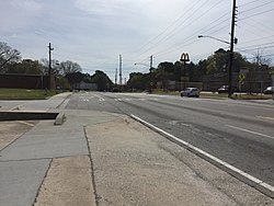
Georgia State Route 139 in Adamsville, Atlanta.JPG
USA Georgia location map.svg
Red pog.svg
Adamsville
Coordinates: 33°45′34″N84°30′20″W / 33.75950°N 84.50542°W / 33.75950; -84.50542 Coordinates: 33°45′34″N84°30′20″W / 33.75950°N 84.50542°W / 33.75950; -84.50542
Country United States
State Georgia
City Atlanta

Adamsville is a predominantly African-American neighborhood on the west side of city Atlanta, Georgia. It is located where Interstate 20 and Interstate 285 meet on the west side.

The entertainers Killer Mike, Bone Crusher, and Stevie-the-Steve-Man Corby came from Adamsville.

The skating rink Cascade Skating Fun Center in the movie ATL is located in Adamsville.

In the year 2000, the city of Atlanta parks and recreation department started construction on a new recreation center. It was finished in 2003 at the price of $13.1 million. The recreation center is known as the C.T. Martin Natatorium and Recreation Center. The 103,000-square-foot (9,600 m2) building features an indoor 50-meter pool and a gymnasium and is 10 times larger than the existing Adamsville Recreation Center.

The new C.T. Martin Natatorium and Recreation Center was built on 9.42 acres (38,100 m2) of land. The recreation center also includes racquetball courts, offices, meeting space, a parking lot for 185 cars and a quarter-mile-long (400 m) walking trail circling the site. [1]

History

Founded as a farming village, Adamsville was possibly named for early resident G. W. Adams, who farmed there in 1882 when it was called Lick Skillet. The name was changed to Adamsville in 1906. [2]

Related Research Articles

Atlanta Capital of Georgia, United States

Atlanta is the capital and most populous city of the U.S. state of Georgia. With a 2020 census population of 498,715, it is the 38th most populous city in the United States. The city serves as the cultural and economic center of the Atlanta metropolitan area, home to more than six million people and the ninth-largest metropolitan area in the nation. Atlanta is the seat of Fulton County, the most populous county in Georgia. Situated among the foothills of the Appalachian Mountains, Atlanta features unique topography that includes rolling hills and the most dense urban tree coverage in the United States.

Fulton County, Georgia County in Georgia, United States

Fulton County is located in the north-central portion of the U.S. state of Georgia. As of the 2020 United States census, the population was 1,066,710, making it the state's most-populous county and its only one with over 1 million inhabitants. Its county seat is Atlanta, the state capital. Approximately 90% of the City of Atlanta is within Fulton County; the other 10% lies within DeKalb County. Fulton County is part of the Atlanta-Sandy Springs-Roswell, GA Metropolitan Statistical Area.

Cobb County, Georgia County in Georgia, United States

Cobb County is a county in the U.S. state of Georgia, located in the Atlanta metropolitan area in the north central portion of the state. As of 2019, the population was 760,141, making it Georgia's third most-populous county. Its county seat and largest city is Marietta.

Canton, Georgia City in Georgia, United States

Canton is a city in and the county seat of Cherokee County, Georgia, United States. As of the 2010 census, the city had a population of 22,958, up from 7,709 in 2000.

College Park, Georgia City in Georgia, United States

College Park is a city in Fulton and Clayton counties, Georgia, United States, adjacent to the southern boundary of the city of Atlanta. As of the 2010 census, the population was 13,942. Hartsfield–Jackson Atlanta International Airport is partially located in the city's boundaries, and the Georgia International Convention Center, owned and operated by the City of College Park, is within the city limits. The city is home to the fourth-largest urban historical district registered with the National Register of Historic Places in the state of Georgia. The city is also home to the Gateway Center Arena, home of the College Park Skyhawks and Atlanta Dream.

Austell, Georgia City in Georgia, United States

Austell is a city in Cobb and Douglas Counties in the U.S. state of Georgia. It is part of the Atlanta metropolitan area. As of the 2010 census, the city had a population of 6,581.

Sandy Springs, Georgia City in Georgia, United States

Sandy Springs is a city in northern Fulton County, Georgia and an inner ring suburb of Atlanta. The city’s population was 93,853 at the 2010 census, and estimated at 109,452 in 2019. It is Georgia's seventh-largest city and the site of several corporate headquarters, including UPS, Newell Brands, Inspire Brands, Cox Communications, and Mercedes-Benz USA's corporate offices.

Duluth, Georgia City in Georgia, United States

Duluth is a city in Gwinnett County, Georgia, United States. Located north of Interstate 85, it is approximately 22 miles (35 km) northeast of Atlanta.

Hartsfield–Jackson Atlanta International Airport International airport in Atlanta, Georgia, United States

Hartsfield–Jackson Atlanta International Airport, also known as Atlanta Hartsfield–Jackson International Airport, Atlanta Airport, Hartsfield, Hartsfield–Jackson or by its airport code ATL is the primary international airport serving Atlanta, Georgia, United States. The airport is located 7 mi (11 km) south of the Downtown Atlanta district. It is named after former Atlanta mayors William B. Hartsfield and Maynard Jackson. ATL covers 4,700 acres (1,902 ha) of land and has five parallel runways. It was the world's busiest airport by passenger traffic from 1998 to 2019, losing its title in 2020 due to the effect of the COVID-19 pandemic in the United States and being surpassed by Guangzhou Baiyun International Airport as a result.

Historic ferries operated on rivers around Atlanta, Georgia area, and became namesakes for numerous current-day roads in north Georgia. Most of the ferries date to the early years of European-American settlement in the 1820s and 1830s, when Cherokee and other Native Americans still occupied part of what became Georgia.

Brookhaven, Georgia City in Georgia, United States

Brookhaven is a city in the northeastern suburbs of Atlanta that is located in western DeKalb County, Georgia, United States, directly northeast of Atlanta. On July 31, 2012, Brookhaven was approved in a referendum to become DeKalb County's 11th city. Incorporation officially took place on December 17, 2012, on which date municipal operations commenced. With a population of around 55,554 as of 2019, it is the largest city in DeKalb County. The new city stretches over 12 square miles (31 km2).

U.S. Route 78

U.S. Route 78 is an east–west United States highway that runs for 715 miles (1,151 km) from Memphis, Tennessee, to Charleston, South Carolina. From Byhalia, Mississippi to Birmingham, Alabama, US 78 is concurrent with Interstate 22. The highway's western terminus is at U.S. Route 64/U.S. Route 70/U.S. Route 79 in Memphis, Tennessee, and its eastern terminus is on Line Street, in Charleston, South Carolina. One of its auxiliary routes, US 278, is actually longer in length than US 78.

Georgia State Route 139

State Route 139 (SR 139) is a 29.8-mile-long (48.0 km) state highway in the northeastern part of the U.S. state of Georgia. It travels within portions of Clayton, Fulton, and Cobb counties and connects the southern suburbs of Atlanta with the town of Mableton, west of the city.

Downtown Atlanta District

Downtown Atlanta is the central business district of Atlanta, Georgia, United States. The largest of the city's three commercial districts, it is the location of many corporate or regional headquarters; city, county, state and federal government facilities; Georgia State University; sporting venues; and most of Atlanta's tourist attractions. It measures approximately four square miles, and had 26,700 residents as of 2010. Similar to other central business districts in the United States, it has recently undergone a transformation that included the construction of new condos and lofts, renovation of historic buildings, and arrival of new residents and businesses.

Interstate 85 (I-85) is a major Interstate Highway that travels northeast-to-southwest in the U.S. state of Georgia. It enters the state at the Alabama state line near West Point, and Lanett, Alabama, traveling through the Atlanta metropolitan area and to the South Carolina state line, where it crosses the Savannah River near Lake Hartwell. I-85 connects northern Georgia with Montgomery, Alabama, to the southwest, and with South Carolina, North Carolina, and Virginia to the northeast. Within Georgia, I-85 is also designated as the unsigned State Route 403 (SR 403).

Cumberland, Georgia Unincorporated area in Georgia, United States

Cumberland is an edge city in Cobb County located in an unincorporated area of the northwest Atlanta metropolitan area, Georgia, United States. It is situated ten miles (16 km) northwest of downtown Atlanta. With approximately 122,000 workers and 103,000 residents, Cumberland is the region's fifth-largest business district, and is marked by several modern skyscrapers rising from the wooded hills above the freeways.

In the U.S. state of Georgia, Interstate 20 (I-20) travels from the Alabama state line to the Savannah River, which is the South Carolina state line. The highway enters the state near Tallapoosa. It travels through the Atlanta metropolitan area and exits the state in Augusta. The highway also travels through the cities of Bremen, Douglasville, Conyers, Covington, and Madison. I-20 has the unsigned state highway designation of State Route 402 (SR 402).

Perimeter Center Community

Perimeter Center is a major edge city in metro Atlanta, Georgia, United States. It is centered on Perimeter Mall, the nucleus around which it has formed. Perimeter Center is located north of Atlanta proper, and lies within three cities: Dunwoody, Sandy Springs, and Brookhaven. It is one of metro Atlanta's largest business districts, and one of the largest edge cities in the United States, comprising over 29 million square feet (2,700,000 m2) of office space, 6 million square feet (560,000 m2) of retail space, and 40,000 residents.

The transportation system of Georgia is a cooperation of complex systems of infrastructure comprising over 1,200 miles (1,900 km) of interstates and more than 120 airports and airbases serving a regional population of 59,425 people.

Judge William Wilson House United States historic place

The Judge William Wilson House was an antebellum house in Atlanta, Georgia. It was built on land in a community west of Atlanta that was then called Adamsville which Wilson had inherited from his father William "Dollar Mill" Wilson (1775–1839) in 1839, and as the area around it developed came to be located in the Fairburn Heights neighborhood, a suburban area west of the Perimeter (I-285). At the end, it was one of only a few remaining antebellum structures still standing in its original location within the Atlanta city limits.

References