
Marietta is a city in and the county seat of Cobb County, Georgia, United States. At the 2020 census, the city had a population of 60,972. The 2019 estimate was 60,867, making it one of Atlanta's largest suburbs. Marietta is the fourth largest of the principal cities by population of the Atlanta metropolitan area.
Techwood Homes was an early public housing project in the Atlanta, Georgia in the United States, opened just before the First Houses. The whites-only Techwood Homes replaced an integrated settlement of low-income people known as Tanyard Bottom or Tech Flats. It was completed on August 15, 1936, but was dedicated on November 29 of the previous year by U.S. President Franklin D. Roosevelt. The new whites-only apartments included bathtubs and electric ranges in each unit, 189 of which had garages. Central laundry facilities, a kindergarten and a library were also provided. Techwood Homes was demolished in advance of the 1996 Olympics and is now Centennial Place Apartments.

West End is a historic neighborhood in the U.S. city of Atlanta, one of the oldest outside Downtown Atlanta, and is listed on the National Register of Historic Places. West End residents are primarily (86%) African American and the neighborhood contains several prominent African American cultural institutions, in addition to being adjacent to the Atlanta University Center complex of HBCUs. West End is located southwest of Castleberry Hill, east of Westview, west of Adair Park Historic District, and just north of Oakland City. Architectural styles within the district include Craftsman Bungalow, Queen Anne, Stick style, Folk Victorian, Colonial Revival, American Foursquare and Neoclassical Revival.

The Fairlie–Poplar Historic District is part of the central business district in downtown Atlanta. It is named for the two streets that cross at its center, northeast-only Fairlie and southeast-only Poplar. Fairlie–Poplar is immediately north of Five Points, the definitive center point and longtime commercial heart of Atlanta. It is roughly bounded on the southwest by Marietta Street, on the southeast by Peachtree Street or Park Place, on the northeast by Luckie Street or Williams Street, and on the northwest by Cone Street or Spring Street. It has smaller city blocks than the rest of the city, and the streets run at a 40° diagonal.

Joseph Neel Reid, also referred to as Neel Reid, was a prominent architect in Atlanta, Georgia, in the early 20th century as a partner in his firm Hentz, Reid and Adler.
The Historic District of the Georgia Institute of Technology, also known as the Old Campus of Georgia Tech or the Hill District, is significant in the areas of architecture, education, engineering and science, as well as landscape architecture. The area is a Registered Historic Place and part of the central campus of Georgia Tech. Located in Midtown Atlanta, Georgia, United States, it is roughly bounded by North Avenue on the South, Bobby Dodd Stadium, a 55,000 seat football stadium on the East, Bobby Dodd Way on the North and Cherry Street on the West.

The Fort Street–Pleasant Street and Norfolk & Western Railroad Viaduct is a bridge carrying six lanes of Fort Street over both Pleasant Street and multiple tracks comprising the Norfolk Southern Railway Detroit District and Conrail Shared Assets Lincoln Secondary and Junction Yard Secondary lines on the border of the Boynton and Oakwood Heights neighborhoods in Detroit, Michigan, just west of the Rouge River. It was listed on the National Register of Historic Places in 2000. The bridge underwent massive repairs and other construction in late 2010 and throughout much of 2011, which included narrowing the Fort Street boulevard north of the viaduct into a six-lane undivided road with a left-turns-only lane. The bridge was removed from the NRHP in 2022.
Knight Park–Howell Station, also known as Howell Station Historic District, is a National historic district and neighborhood in, Atlanta, Georgia. Almost all buildings in the area were destroyed in the American Civil War, in Sherman's March to the Sea, and all of the buildings in the district were built after 1864. The neighborhood was listed on the National Register of Historic Places in 1997.
West Midtown, also known as Westside, is a colloquial area, comprising many historical neighborhoods located in Atlanta, Georgia. Once largely industrial, West Midtown is now the location of urban lofts, art galleries, live music venues, retail and restaurants.
Marietta Street Artery is an officially defined neighborhood of the city of Atlanta, Georgia, part of the West Midtown area of Atlanta, also known as the "Westside."

The J. Mack Robinson College of Business Administration Building is a 14-story highrise at the corner of Broad and Marietta streets in the Fairlie-Poplar district of downtown Atlanta, which houses the business school of Georgia State University. When completed in 1901 as the Empire Building, it was the first steel-frame structure and the tallest in the city, until surpassed by the Candler Building in 1906.
The Southern Railway North Avenue Yards, now repurposed as the NorthYards business park, is located just west of the railway line northwest from downtown Atlanta, south of the Marietta Street Artery neighborhood, rich in industrial history. The Yards represent a microcosm in changes in American railroads over the course of the 20th century.

The Means Street Historic District in the Marietta Street Artery district of Atlanta consists of historic, mostly 19th and early 20th century warehouse and industrial buildings now converted to office space along one block of Means St. between Bankhead and Ponders Aves. Means Street was named for landowner Alexander Means and was plotted in 1869. Warehouses were built in this early industrial corridor, then known as Bellwood, along the railroad line. Mule-pulled trolleys brought workers starting in 1882, and these became electrified in 1894.
Westside Provisions is a mixed use neighborhood located in the West Midtown area of Atlanta, Georgia, United States.
The King Plow/Railroad Historic District is a proposed historic district in Midtown West, Atlanta, Georgia. Creation of the district was approved at the state level in 2001 but it has not yet received national certification.
The Exposition Cotton Mills were cotton mills located in what is now the West Midtown area of Atlanta at the upper end of the Marietta Street Artery, an area rich with industrial heritage architecture. They were built on what had been Oglethorpe Park for the International Cotton Exposition of 1881 and were demolished in 1952. A warehouse and distribution center now occupy the site.
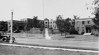
The Northwest Marietta Historic District is a 230-acre (93 ha) historic district in Marietta, Georgia that was listed on the National Register of Historic Places in 1975. It includes Late Victorian, Greek Revival, Plantation Plain, and other architecture.
Marietta Street is a historic street in Downtown Atlanta. The street leads from Atlanta towards the town of Marietta, as its name indicates. It begins as one of the five streets intersecting at Five Points, leading northwest, forming the southern border of Downtown's Fairlie-Poplar district, continuing through Downtown's Luckie Marietta district, then entering West Midtown's Marietta Street Artery neighborhood, until terminating at its junction with West Marietta St., Brady Ave., and 8th St.

Ashby Street Car Barn, locally known as the Ashby Street Trolley Barn, is a historic interurban carhouse in Atlanta, Georgia. It was constructed by the Atlanta Northern Railway Company in 1927, replacing a previous structure built in 1904. The carhouse was the major maintenance facility for the Atlanta/Marietta interurban, which ran until January 31, 1947. It had six parallel tracks inside.


