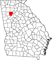
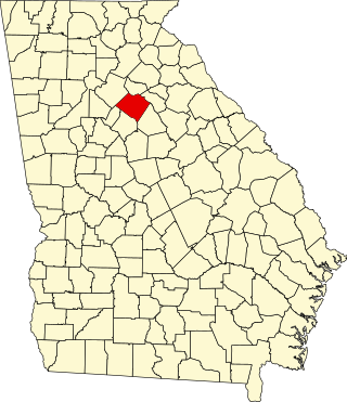
[2] Name on the Register Image Date listed [3] Location City or town Description 1 Acworth Downtown Historic District Acworth Downtown Historic District April 19, 2006 (# 06000286 Roughly bounded by Southside Dr., Federal and Lemon Sts, and Senator Richard B. Russell Ave. 34°03′58″N 84°40′44″W / 34.066111°N 84.678889°W / 34.066111; -84.678889 (Acworth Downtown Historic District ) Acworth 2 Atlanta-Frasier Street Historic District Atlanta-Frasier Street Historic District June 20, 1995 (# 95000737 Atlanta and Frasier Sts. between GA 120 Loop and Dixie Ave. 33°56′43″N 84°32′47″W / 33.945278°N 84.546389°W / 33.945278; -84.546389 (Atlanta-Frasier Street Historic District ) Marietta 3 J. C. Bankston Rock House Upload image November 25, 1994 (# 94001387 901 Industrial Dr., Dobbins Air Reserve Base 33°55′30″N 84°31′36″W / 33.92513°N 84.52672°W / 33.92513; -84.52672 (J. C. Bankston Rock House ) Marietta 4 Bethel AME Church Bethel AME Church May 9, 2002 (# 02000453 4683 Bell St. 34°04′07″N 84°40′41″W / 34.068611°N 84.678056°W / 34.068611; -84.678056 (Bethel AME Church ) Acworth 5 Big Shanty Village Historic District Big Shanty Village Historic District March 20, 1980 (# 80000995 Park Ave., Whitfield Pl., Main, Harris, Lewis, and Cherokee Sts. 34°01′27″N 84°36′54″W / 34.024167°N 84.615°W / 34.024167; -84.615 (Big Shanty Village Historic District ) Kennesaw 6 Braswell-Carnes House Braswell-Carnes House March 1, 1984 (# 84000974 2430 Burnt Hickory Rd., NW 33°57′57″N 84°37′21″W / 33.96586°N 84.62263°W / 33.96586; -84.62263 (Braswell-Carnes House ) Marietta 7 Arnoldus Brumby House Arnoldus Brumby House August 29, 1977 (# 77000417 472 Powder Springs St. 33°56′37″N 84°33′08″W / 33.943611°N 84.552222°W / 33.943611; -84.552222 (Arnoldus Brumby House ) Marietta 8 Hiram Butler House Hiram Butler House February 2, 1995 (# 94001637 2382 Pine Mountain Rd., NW. 34°00′35″N 84°37′47″W / 34.009722°N 84.629722°W / 34.009722; -84.629722 (Hiram Butler House ) Kennesaw 9 Butner-Mctyre General Store Butner-Mctyre General Store February 1, 2006 (# 05001593 4455 Marietta St. 33°51′32″N 84°41′04″W / 33.858889°N 84.684444°W / 33.858889; -84.684444 (Butner-Mctyre General Store ) Powder Springs 10 Camp McDonald Camp McDonald March 20, 1980 (# 80000996 Off U.S. 41 34°01′18″N 84°37′05″W / 34.021667°N 84.618056°W / 34.021667; -84.618056 (Camp McDonald ) Kennesaw 11 J. H. Carmichael Farm and General Store Upload image June 30, 1980 (# 80001002 SE of Smyrna at 501 Log Cabin Rd. 33°50′36″N 84°29′02″W / 33.843333°N 84.483889°W / 33.843333; -84.483889 (J. H. Carmichael Farm and General Store ) Smyrna 12 Israel Causey House Israel Causey House August 13, 1975 (# 75000584 5909 Maxham Rd. 33°48′36″N 84°37′05″W / 33.81°N 84.618056°W / 33.81; -84.618056 (Israel Causey House ) Austell 13 Andrew J. Cheney House Andrew J. Cheney House July 22, 1979 (# 79000713 SW of Marietta at Powder Springs and Bankstone Rds. 33°53′07″N 84°37′07″W / 33.88524°N 84.61854°W / 33.88524; -84.61854 (Andrew J. Cheney House ) Marietta 14 Cherokee Street Historic District Cherokee Street Historic District March 20, 1980 (# 80000997 Cherokee St. 34°01′34″N 84°36′36″W / 34.026111°N 84.61°W / 34.026111; -84.61 (Cherokee Street Historic District ) Kennesaw 15 Church Street-Cherokee Street Historic District Upload image December 3, 1985 (# 85003059 Roughly bounded by Margaret Ave. and Chicopee Dr., DeSoto Ave., Montgomery and Brumby, and Campbell Hill Sts. 33°57′44″N 84°32′53″W / 33.962222°N 84.548056°W / 33.962222; -84.548056 (Church Street-Cherokee Street Historic District ) Marietta 16 Clarkdale Historic District Clarkdale Historic District December 23, 1987 (# 87002134 Powder Springs-Austell Rd. 33°49′48″N 84°39′15″W / 33.83°N 84.654167°W / 33.83; -84.654167 (Clarkdale Historic District ) Clarkdale 17 Collins Avenue Historic District Collins Avenue Historic District July 5, 2001 (# 01000707 Collins Ave. 34°04′00″N 84°41′10″W / 34.066667°N 84.686111°W / 34.066667; -84.686111 (Collins Avenue Historic District ) Acworth 18 Stephen D. Cowan House Stephen D. Cowan House November 15, 2002 (# 02001299 4940 Cowan Rd. 34°04′24″N 84°39′18″W / 34.073333°N 84.655°W / 34.073333; -84.655 (Stephen D. Cowan House ) Acworth 19 Frobel-Knight-Borders House Upload image July 21, 1995 (# 95000901 1001 Allgood Rd. 33°58′31″N 84°31′25″W / 33.975278°N 84.523611°W / 33.975278; -84.523611 (Frobel-Knight-Borders House ) Marietta 20 The General The General June 19, 1973 (# 73000617 Big Shanty Museum of Cherokee St. 34°01′25″N 84°36′52″W / 34.023611°N 84.614444°W / 34.023611; -84.614444 (The General ) Kennesaw Subject of the Great Locomotive Chase of the American Civil War, located at Southern Museum of Civil War and Locomotive History 21 Gilgal Church Battle Site Gilgal Church Battle Site January 23, 1975 (# 75000585 9 mi (14 km) W of Marietta on Sandtown Rd. 33°58′18″N 84°39′54″W / 33.971667°N 84.665°W / 33.971667; -84.665 (Gilgal Church Battle Site ) Marietta 22 Glover-McLeod-Garrison House Glover-McLeod-Garrison House March 25, 1977 (# 77000418 250 Garrison Rd., SE (that part of the street is called Magnolia Chase Dr as of 2017) 33°56′07″N 84°32′52″W / 33.93514°N 84.54785°W / 33.93514; -84.54785 (Glover-McLeod-Garrison House ) Marietta 23 Johnston's River Line Upload image July 5, 1973 (# 73000618 SE of Mableton off U.S. 78 at Chattachooche River 33°47′31″N 84°31′23″W / 33.791944°N 84.523056°W / 33.791944; -84.523056 (Johnston's River Line ) Mableton Boundary increase May 18, 2015. 24 Kennesaw Mountain National Battlefield Park Kennesaw Mountain National Battlefield Park October 15, 1966 (# 66000063 2 mi (3.2 km) W of Marietta 33°56′59″N 84°35′37″W / 33.949722°N 84.593611°W / 33.949722; -84.593611 (Kennesaw Mountain National Battlefield Park ) Marietta administered by the National Park Service 25 Lake Acworth Beach and Bathhouse Lake Acworth Beach and Bathhouse January 7, 2010 (# 09001202 Lakeshore Dr. 34°03′39″N 84°40′56″W / 34.060706°N 84.682208°W / 34.060706; -84.682208 (Lake Acworth Beach and Bathhouse ) Acworth 26 Lemon Street School Upload image February 23, 2024 (# 100009980 350 Lemon Street 33°57′19″N 84°32′31″W / 33.9552°N 84.5420°W / 33.9552; -84.5420 (Lemon Street School ) Marietta 27 Robert Mable House and Cemetery Robert Mable House and Cemetery September 1, 1988 (# 87001345 5239 Floyd Rd. 33°49′37″N 84°34′25″W / 33.826944°N 84.573611°W / 33.826944; -84.573611 (Robert Mable House and Cemetery ) Mableton 28 Marietta National Cemetery Marietta National Cemetery September 18, 1998 (# 98001170 500 Washington Ave. 33°57′04″N 84°32′27″W / 33.951111°N 84.540833°W / 33.951111; -84.540833 (Marietta National Cemetery ) Marietta 29 William Gibbs McAdoo House William Gibbs McAdoo House November 17, 1978 (# 78000975 SW of Marietta on GA 5 33°54′28″N 84°36′15″W / 33.907778°N 84.604167°W / 33.907778; -84.604167 (William Gibbs McAdoo House ) Marietta 30 Midway Presbyterian Church and Cemetery Midway Presbyterian Church and Cemetery December 29, 1986 (# 86003526 4635 Dallas Hwy./GA 120 SW 33°56′37″N 84°41′15″W / 33.943611°N 84.6875°W / 33.943611; -84.6875 (Midway Presbyterian Church and Cemetery ) Powder Springs 31 Tarleton Moore House Tarleton Moore House May 31, 2006 (# 06000453 4784 Northside Dr. 34°04′12″N 84°41′12″W / 34.07°N 84.686667°W / 34.07; -84.686667 (Tarleton Moore House ) Acworth 32 North Main Street Historic District North Main Street Historic District March 20, 1980 (# 80000999 N. Main St. 34°01′33″N 84°37′14″W / 34.025833°N 84.620556°W / 34.025833; -84.620556 (North Main Street Historic District ) Kennesaw 33 Northwest Marietta Historic District Northwest Marietta Historic District June 11, 1975 (# 75000586 Roughly bounded by RR tracks, NW along Kennesaw Ave., McDonald St., and Whitlock Ave. 33°57′36″N 84°33′22″W / 33.96°N 84.556111°W / 33.96; -84.556111 (Northwest Marietta Historic District ) Marietta 34 Solomon and Penelopy Pace House Solomon and Penelopy Pace House May 20, 2009 (# 09000325 3057 Paces Mill Rd. 33°52′01″N 84°27′53″W / 33.86694°N 84.46472°W / 33.86694; -84.46472 (Solomon and Penelopy Pace House ) Vinings 35 George A. Power House George A. Power House July 11, 2001 (# 01000720 Hyde Rd. 33°57′38″N 84°23′42″W / 33.960556°N 84.395°W / 33.960556; -84.395 (George A. Power House ) Marietta 36 Power-Hyde Farm Historic District Upload image August 28, 2024 (# 100010808 575 Hyde Road 33°57′55″N 84°23′27″W / 33.9654°N 84.3908°W / 33.9654; -84.3908 (Power-Hyde Farm Historic District ) Marietta 37 John W. Rice Summer Cottage John W. Rice Summer Cottage April 8, 1983 (# 83000189 254 Concord Rd. 33°50′59″N 84°33′33″W / 33.849722°N 84.559167°W / 33.849722; -84.559167 (John W. Rice Summer Cottage ) Smyrna 38 Riverview Carousel at Six Flags Over Georgia Riverview Carousel at Six Flags Over Georgia January 27, 1995 (# 94001639 7561 Six Flags Pkwy. 33°46′00″N 84°33′03″W / 33.766667°N 84.550833°W / 33.766667; -84.550833 (Riverview Carousel at Six Flags Over Georgia ) Austell A carousel at Six Flags Over Georgia 39 William and Hannah Root House William and Hannah Root House March 12, 2014 (# 14000061 145 Denmead St., NW. 33°57′16″N 84°33′07″W / 33.9545515°N 84.5518412°W / 33.9545515; -84.5518412 (William and Hannah Root House ) Marietta In the Northwest Marietta Historic District 40 Ruff's Mill and Concord Covered Bridge Ruff's Mill and Concord Covered Bridge November 24, 1980 (# 80001001 10 Concord Rd., SW 33°50′56″N 84°33′30″W / 33.848889°N 84.558333°W / 33.848889; -84.558333 (Ruff's Mill and Concord Covered Bridge ) Smyrna 41 Smith-Manning House Smith-Manning House December 2, 2014 (# 14000969 360 Manning Rd. 33°56′38″N 84°34′56″W / 33.943866°N 84.582099°W / 33.943866; -84.582099 (Smith-Manning House ) Marietta 42 Sope Creek Ruins Sope Creek Ruins April 27, 1973 (# 73000619 Address Restricted (at the intersection of Paper Mill Road and Sope Creek) 33°56′26″N 84°26′16″W / 33.94045°N 84.4378°W / 33.94045; -84.4378 (Sope Creek Ruins ) Marietta 43 Summers Street Historic District Summers Street Historic District March 20, 1980 (# 80001000 Summers St. 34°01′10″N 84°36′49″W / 34.019444°N 84.613611°W / 34.019444; -84.613611 (Summers Street Historic District ) Kennesaw 44 Taylor-Brawner House and Brawner Sanitarium Taylor-Brawner House and Brawner Sanitarium March 27, 2012 (# 12000149 3180 Atlanta Rd 33°52′32″N 84°30′24″W / 33.87553°N 84.50678°W / 33.87553; -84.50678 (Taylor-Brawner House and Brawner Sanitarium ) Smyrna website [usurped] 45 Union Field Fortifications at Henderson Road Union Field Fortifications at Henderson Road May 18, 2015 (# 15000223 6000 Henderson Rd., SE. 33°48′24″N 84°31′21″W / 33.8066°N 84.5225°W / 33.8066; -84.5225 (Union Field Fortifications at Henderson Road ) Mableton vicinity 46 Washington Avenue Historic District Upload image August 10, 1989 (# 89001102 Roughly bounded by Lawrence St., Rigsby St., Washington Ave., and Haynes St. 33°57′09″N 84°32′36″W / 33.9525°N 84.543333°W / 33.9525; -84.543333 (Washington Avenue Historic District ) Marietta 47 Whitlock Avenue Historic District Upload image September 14, 1989 (# 89001218 Roughly bounded by McCord St., Oakmont St., Whitlock Ave., Powder Springs Rd., Trammel St., Maxwell Ave., and Hazel St. 33°57′04″N 84°33′26″W / 33.951111°N 84.557222°W / 33.951111; -84.557222 (Whitlock Avenue Historic District ) Marietta 48 Zion Baptist Church Zion Baptist Church July 11, 1990 (# 90001026 149 Haynes St. 33°57′18″N 84°32′51″W / 33.955°N 84.5475°W / 33.955; -84.5475 (Zion Baptist Church ) Marietta