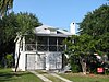
[2] Name on the Register Image Date listed [3] Location City or town Description 1 Edmund and Mildred Abrahams Raised Tybee Cottage Edmund and Mildred Abrahams Raised Tybee Cottage January 27, 2020 (# 100004900 4 Eighth St. 32°00′13″N 80°50′36″W / 32.00355°N 80.84346°W / 32.00355; -80.84346 (Edmund and Mildred Abrahams Raised Tybee Cottage ) Tybee Island 2 Ardsley Park-Chatham Crescent Historic District Ardsley Park-Chatham Crescent Historic District August 15, 1985 (# 85001787 Roughly bounded by Ardsley Pk., Chatham Crescent, Bull St., Baldwin Pk. and Ardmore 32°02′50″N 81°05′42″W / 32.047222°N 81.095°W / 32.047222; -81.095 (Ardsley Park-Chatham Crescent Historic District ) Savannah 3 Atlantic Greyhound Bus Terminal Atlantic Greyhound Bus Terminal December 13, 2016 (# 16000837 109 Martin Luther King, Jr. Blvd. 32°04′47″N 81°05′51″W / 32.079828°N 81.097621°W / 32.079828; -81.097621 (Atlantic Greyhound Bus Terminal ) Savannah Now houses The Grey Bar & Restaurant. Proposed nomination form [Usurped! ] Press release [Usurped! ] 4 Bethesda Home for Boys Bethesda Home for Boys September 12, 1973 (# 73000614 S of Savannah at Ferguson Ave. and Bethesda Rd. 31°57′34″N 81°05′43″W / 31.95944°N 81.09528°W / 31.95944; -81.09528 (Bethesda Home for Boys ) Savannah 5 Bonaventure Cemetery Bonaventure Cemetery February 2, 2001 (# 01000035 Bonaventure Rd., 1 mi. N of US 80 32°02′38″N 81°02′44″W / 32.043889°N 81.045556°W / 32.043889; -81.045556 (Bonaventure Cemetery ) Savannah 6 Bordley Cottage-Beach View House Bordley Cottage-Beach View House June 27, 2014 (# 14000345 1701 Butler Ave. 31°59′27″N 80°51′01″W / 31.9909559°N 80.8501883°W / 31.9909559; -80.8501883 (Bordley Cottage-Beach View House ) Tybee Island 7 The Carbo House The Carbo House May 21, 2010 (# 10000273 9 Tybrisa St. 31°59′31″N 80°50′53″W / 31.99189°N 80.84805°W / 31.99189; -80.84805 (The Carbo House ) Tybee Island Weekly boarding as of 2016 8 Carver Village Historic District Carver Village Historic District January 24, 2019 (# 100003340 Bounded by W. Gwinnett & Endley Sts., Allen Blun, & Collat Aves. 32°04′16″N 81°07′35″W / 32.071084°N 81.126509°W / 32.071084; -81.126509 (Carver Village Historic District ) Savannah 9 Central of Georgia Depot and Trainshed Central of Georgia Depot and Trainshed December 8, 1976 (# 76000610 Martin Luther King Jr Blvd (formerly W. Broad St.) and Liberty Sts. 32°04′34″N 81°05′57″W / 32.07607°N 81.09923°W / 32.07607; -81.09923 (Central of Georgia Depot and Trainshed ) Savannah Currently the site of the Savannah History Museum 10 Central of Georgia Railroad: Savannah Shops and Terminal Facilities Central of Georgia Railroad: Savannah Shops and Terminal Facilities June 2, 1978 (# 78000970 Martin Luther King Jr Blvd (formerly W. Broad St.) and Railroad Ave. 32°04′33″N 81°06′05″W / 32.07571°N 81.10126°W / 32.07571; -81.10126 (Central of Georgia Railroad: Savannah Shops and Terminal Facilities ) Savannah A National Historic Landmark and currently the home of the Georgia State Railroad Museum ; expansion of the Central of Georgia Depot and Trainshed listing 11 Central of Georgia Railway Company Shop Property Central of Georgia Railway Company Shop Property March 5, 1970 (# 70000199 Between W. Jones St. and Louisville Rd. 32°04′37″N 81°05′56″W / 32.07700°N 81.09881°W / 32.07700; -81.09881 (Central of Georgia Railway Company Shop Property ) Savannah Now an extension of the SCAD Museum of Art 12 Charity Hospital Charity Hospital May 2, 1985 (# 85000934 644 W. 36th St. 32°03′37″N 81°06′29″W / 32.060278°N 81.108056°W / 32.060278; -81.108056 (Charity Hospital ) Savannah Now Heritage Place Apartments 13 CSS Georgia (ironclad) CSS Georgia (ironclad) February 10, 1987 (# 86003746 At the bottom of the Savannah River 32°05′05″N 81°02′09″W / 32.0847°N 81.0358°W / 32.0847; -81.0358 (CSS Georgia (ironclad) ) Savannah 14 Cuyler-Brownville Historic District Cuyler-Brownville Historic District February 13, 1998 (# 98000028 Roughly bounded by Anderson Ln., W. 31st St., Montgomery St., Victory Dr., Ogeechee Rd., and Hopkins St. 32°03′30″N 81°06′29″W / 32.058333°N 81.108056°W / 32.058333; -81.108056 (Cuyler-Brownville Historic District ) Savannah 15 Daffin Park-Parkside Place Historic District Daffin Park-Parkside Place Historic District May 12, 1999 (# 99000554 Bounded by Victory Dr., Waters Ave., Bee St. and 51st Street Ln. 32°02′37″N 81°04′55″W / 32.043611°N 81.081944°W / 32.043611; -81.081944 (Daffin Park-Parkside Place Historic District ) Savannah 16 Isaiah Davenport House Isaiah Davenport House September 22, 1972 (# 72000374 324 E. State St. 32°04′38″N 81°05′18″W / 32.077222°N 81.088333°W / 32.077222; -81.088333 (Isaiah Davenport House ) Savannah 17 Drayton Tower Drayton Tower October 16, 2013 (# 13000826 102 E. Liberty St. 32°04′29″N 81°05′31″W / 32.074607°N 81.091956°W / 32.074607; -81.091956 (Drayton Tower ) Savannah Originally named the Drayton Arms Apartments 18 Drouillard-Maupas House Drouillard-Maupas House May 13, 1991 (# 91000558 2422 Abercorn St. 32°03′11″N 81°05′56″W / 32.053056°N 81.098889°W / 32.053056; -81.098889 (Drouillard-Maupas House ) Savannah 19 Dutton-Waller Raised Tybee Cottage Dutton-Waller Raised Tybee Cottage July 24, 2008 (# 08000711 1416 7th Ave. 31°59′44″N 80°51′13″W / 31.995692°N 80.853719°W / 31.995692; -80.853719 (Dutton-Waller Raised Tybee Cottage ) Tybee Island 20 Eastside Historic District Eastside Historic District November 7, 2002 (# 02001292 Roughly bounded by E. Broad (now MLK Blvd), Cedar, Gwinnett and Anderson Sts. 32°03′36″N 81°05′03″W / 32.06°N 81.084167°W / 32.06; -81.084167 (Eastside Historic District ) Savannah 21 Eureka Club-Farr's Point Eureka Club-Farr's Point July 8, 2009 (# 09000491 2326 East Blvd. on Wilmington Island 31°58′18″N 81°00′01″W / 31.97180°N 81.00015°W / 31.97180; -81.00015 (Eureka Club-Farr's Point ) Savannah 22 Fairway Oaks-Greenview Historic District Fairway Oaks-Greenview Historic District March 31, 2009 (# 09000184 Bounded approximately by DeRenne Drive, Waters Avenue, Truman Parkway, and Casey Canal, and the Live Oaks Golf Course 32°01′15″N 81°05′31″W / 32.020711°N 81.092058°W / 32.020711; -81.092058 (Fairway Oaks-Greenview Historic District ) Savannah 23 Federal Building and U.S. Courthouse Federal Building and U.S. Courthouse June 7, 1974 (# 74000663 Wright Sq. 32°04′41″N 81°05′35″W / 32.078056°N 81.093056°W / 32.078056; -81.093056 (Federal Building and U.S. Courthouse ) Savannah 24 First Bryan Baptist Church First Bryan Baptist Church May 22, 1978 (# 78000971 575 W. Bryan St. 32°04′55″N 81°05′57″W / 32.08208°N 81.09906°W / 32.08208; -81.09906 (First Bryan Baptist Church ) Savannah 25 Fort James Jackson Fort James Jackson February 18, 1970 (# 70000200 Islands Expwy. 32°04′55″N 81°02′10″W / 32.081944°N 81.036111°W / 32.081944; -81.036111 (Fort James Jackson ) Savannah National Historic Landmark 26 Fort Pulaski National Monument Fort Pulaski National Monument October 15, 1966 (# 66000064 17 mi. W of Savannah, Cockspur Island 32°01′41″N 80°53′50″W / 32.028056°N 80.897222°W / 32.028056; -80.897222 (Fort Pulaski National Monument ) Savannah administered by the National Park Service 27 Fort Screven Historic District Fort Screven Historic District May 25, 1982 (# 82002393 Tilton, Butler, Van Horn, Railroad and Alger Aves., and Pulaski Rd. 32°01′24″N 80°51′00″W / 32.023333°N 80.85°W / 32.023333; -80.85 (Fort Screven Historic District ) Tybee Island 28 Gordonston Historic District Gordonston Historic District October 11, 2001 (# 01000741 Roughly bounded by Skidaway Rd., Goebel Ave., Gwinnett St., and Pennsylvania Ave. 32°03′17″N 81°03′47″W / 32.054722°N 81.063056°W / 32.054722; -81.063056 (Gordonston Historic District ) Savannah 29 Green-Meldrim House Green-Meldrim House January 21, 1974 (# 74000664 Macon and Bull Sts. 32°04′26″N 81°05′41″W / 32.073889°N 81.094722°W / 32.073889; -81.094722 (Green-Meldrim House ) Savannah National Historic Landmark 30 Hill Hall at Savannah State College Hill Hall at Savannah State College April 23, 1981 (# 81000197 Savannah State College campus 32°01′27″N 81°03′23″W / 32.024053°N 81.056475°W / 32.024053; -81.056475 (Hill Hall at Savannah State College ) Savannah 31 W. B. Hodgson Hall W. B. Hodgson Hall March 25, 1977 (# 77000413 501 Whitaker St. 32°04′13″N 81°05′49″W / 32.070278°N 81.096944°W / 32.070278; -81.096944 (W. B. Hodgson Hall ) Savannah 32 Isle of Hope Historic District Isle of Hope Historic District September 7, 1984 (# 84003874 Roughly bounded by Skidaway River, Parkersburg Rd., Island, Cornus, and Noble Glen Drs. 31°58′49″N 81°03′21″W / 31.980278°N 81.055833°W / 31.980278; -81.055833 (Isle of Hope Historic District ) Savannah 33 J. Herbert and Julia Johnson Raised Tybee Cottage J. Herbert and Julia Johnson Raised Tybee Cottage May 21, 2008 (# 08000441 1306 Jones Ave. 31°59′48″N 80°50′58″W / 31.996703°N 80.849564°W / 31.996703; -80.849564 (J. Herbert and Julia Johnson Raised Tybee Cottage ) Tybee Island 34 Kensington Park-Groveland Historic District Kensington Park-Groveland Historic District August 30, 2014 (# 14000533 Roughly bounded by DeRenne & Waters Aves., Abercorn & Johnston Sts. 32°01′24″N 81°06′12″W / 32.0233°N 81.1033°W / 32.0233; -81.1033 (Kensington Park-Groveland Historic District ) Savannah [4] 35 Laurel Grove-North Cemetery Laurel Grove-North Cemetery August 4, 1983 (# 83000187 W. Anderson St. 32°03′53″N 81°06′31″W / 32.064722°N 81.108611°W / 32.064722; -81.108611 (Laurel Grove-North Cemetery ) Savannah 36 Laurel Grove-South Cemetery Laurel Grove-South Cemetery September 6, 1978 (# 78000972 37th St. 32°03′37″N 81°06′57″W / 32.060278°N 81.115833°W / 32.060278; -81.115833 (Laurel Grove-South Cemetery ) Savannah 37 Lebanon Plantation Lebanon Plantation November 29, 1979 (# 79000704 SW of Savannah 32°00′22″N 81°12′38″W / 32.006°N 81.2105°W / 32.006; -81.2105 (Lebanon Plantation ) Savannah Private property, gated 38 Juliette Gordon Low Historic District Juliette Gordon Low Historic District October 15, 1966 (# 66000276 10 Oglethorpe Ave., E., 330 Drayton St., 329 Abercorn St. 32°04′37″N 81°05′33″W / 32.077062°N 81.092480°W / 32.077062; -81.092480 (Juliette Gordon Low Historic District ) Savannah National Historic Landmark , The district consists of three buildings associated with the origins of the Girl Scouts of the USA , the "Juliette Gordon Low Birthplace ," the "Andrew Low House ," and the "Andrew Low Carriage House ". 39 Massie Common School House Massie Common School House April 13, 1977 (# 77000414 207 E. Gordon St. 32°04′13″N 81°05′33″W / 32.07020°N 81.09245°W / 32.07020; -81.09245 (Massie Common School House ) Savannah 40 Morgan-Ille Cottage Morgan-Ille Cottage July 24, 2008 (# 08000713 703 2nd Ave. 32°00′19″N 80°50′44″W / 32.005211°N 80.845625°W / 32.005211; -80.845625 (Morgan-Ille Cottage ) Tybee Island 41 Mulberry Grove Site Upload image July 17, 1975 (# 75000575 Address Restricted (305 S Coastal Hwy) 32°11′N 81°10′W / 32.19°N 81.16°W / 32.19; -81.16 (Mulberry Grove Site ) Port Wentworth Left in ruins, reportedly only a marker was left and it is missing [5] 42 Mulherin-Righton Raised Tybee Cottage Mulherin-Righton Raised Tybee Cottage April 29, 2008 (# 08000349 14 8th Pl. 32°00′10″N 80°50′39″W / 32.002778°N 80.844244°W / 32.002778; -80.844244 (Mulherin-Righton Raised Tybee Cottage ) Tybee Island 43 New Ogeechee Missionary Baptist Church New Ogeechee Missionary Baptist Church August 8, 2001 (# 01000854 751 Chevis Rd. 31°58′40″N 81°14′57″W / 31.977778°N 81.249167°W / 31.977778; -81.249167 (New Ogeechee Missionary Baptist Church ) Savannah 44 Nicholsonville Baptist Church Nicholsonville Baptist Church May 22, 1978 (# 78000969 White Bluff Rd. 31°57′30″N 81°08′18″W / 31.958333°N 81.138333°W / 31.958333; -81.138333 (Nicholsonville Baptist Church ) Nicholsonville 45 Ossabaw Island Upload image May 6, 1996 (# 96000468 7 mi. S of Savannah, bounded by the Atlantic Ocean, Bear R., Ogeechee R., and St. Catherine's Sound 31°47′40″N 81°06′44″W / 31.794444°N 81.112222°W / 31.794444; -81.112222 (Ossabaw Island ) Savannah 46 Owens-Thomas House Owens-Thomas House May 11, 1976 (# 76000611 124 Abercorn St. 32°04′39″N 81°05′22″W / 32.07738°N 81.08940°W / 32.07738; -81.08940 (Owens-Thomas House ) Savannah National Historic Landmark 47 Pine Gardens Historic District Pine Gardens Historic District November 5, 2014 (# 14000890 Roughly bounded by Goebel Ave., Beech & Capitol Sts. 32°04′00″N 81°03′23″W / 32.0666°N 81.0565°W / 32.0666; -81.0565 (Pine Gardens Historic District ) Savannah 48 James and Odessa Rourke, Jr., Raised Tybee Cottage James and Odessa Rourke, Jr., Raised Tybee Cottage September 23, 2010 (# 10000804 702 14th St. 31°59′49″N 80°51′10″W / 31.996944°N 80.852778°W / 31.996944; -80.852778 (James and Odessa Rourke, Jr., Raised Tybee Cottage ) Tybee Island 49 St. Bartholomew's Church St. Bartholomew's Church June 17, 1982 (# 82002391 Chevis Rd. 31°58′13″N 81°14′42″W / 31.970278°N 81.245°W / 31.970278; -81.245 (St. Bartholomew's Church ) Burroughs 50 St. Philip AME Church St. Philip AME Church August 2, 1984 (# 84000959 613 Martin Luther King Jr Blvd (formerly W. Broad St.) 32°04′13″N 81°06′05″W / 32.070278°N 81.101389°W / 32.070278; -81.101389 (St. Philip AME Church ) Savannah 51 Savannah and Ogeechee Canal Savannah and Ogeechee Canal August 11, 1997 (# 97000814 Roughly along I-95, between the Savannah and Ogeechee Rivers 32°03′40″N 81°13′18″W / 32.06112°N 81.22157°W / 32.06112; -81.22157 (Savannah and Ogeechee Canal ) Chatham 52 Savannah Beach Town Hall and Auditorium Savannah Beach Town Hall and Auditorium May 27, 2022 (# 100007755 403 Butler Ave. 32°00′31″N 80°50′35″W / 32.00869°N 80.84300°W / 32.00869; -80.84300 (Savannah Beach Town Hall and Auditorium ) Tybee Island 53 Savannah Historic District Savannah Historic District November 13, 1966 (# 66000277 Bounded by E. Broad, Gwinnett, and W. Broad Sts. and the Savannah River (Broad St. is now MLK Blvd) 32°04′28″N 81°05′30″W / 32.074444°N 81.091667°W / 32.074444; -81.091667 (Savannah Historic District ) Savannah National Historic Landmark 54 Savannah Pharmacy and Fonvielle Office Building Upload image February 20, 2013 (# 13000023 914-918 Martin Luther King, Jr. Blvd. 32°04′02″N 81°06′08″W / 32.067262°N 81.102112°W / 32.067262; -81.102112 (Savannah Pharmacy and Fonvielle Office Building ) Savannah Demolished in 2014 [6] NPS
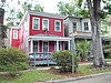
55 Savannah Victorian Historic District Savannah Victorian Historic District December 11, 1974 (# 74000665 Roughly bounded by Gwinnett, Price, Anderson, and Montgomery Sts.; also the area bounded by Gwinnett, Anderson and 31st Sts. 32°03′53″N 81°05′49″W / 32.064722°N 81.096944°W / 32.064722; -81.096944 (Savannah Victorian Historic District ) Savannah Second set of boundaries represents a boundary increase of May 20, 1982 (refnum 82002392) 56 Savannah Water Works Pump House Savannah Water Works Pump House January 24, 2022 (# 100007368 1204 West Gwinnett St. 32°04′18″N 81°06′49″W / 32.0717°N 81.1137°W / 32.0717; -81.1137 (Savannah Water Works Pump House ) Savannah 57 William Scarbrough House William Scarbrough House June 22, 1970 (# 70000201 41 Martin Luther King Jr Blvd (formerly W. Broad St.) 32°04′52″N 81°05′50″W / 32.08117°N 81.09727°W / 32.08117; -81.09727 (William Scarbrough House ) Savannah National Historic Landmark , now houses the Ships of the Sea Maritime Museum 58 Sea View Apartments Sea View Apartments April 22, 2003 (# 03000286 7 18th St. 31°59′21″N 80°50′57″W / 31.98909°N 80.84930°W / 31.98909; -80.84930 (Sea View Apartments ) Tybee Island 59 Slotin Building Slotin Building March 24, 1983 (# 83000188 101 Martin Luther King Jr Blvd (formerly W. Broad St.) 32°04′48″N 81°05′52″W / 32.08007°N 81.09766°W / 32.08007; -81.09766 (Slotin Building ) Savannah Now Bergen Hall of the Savannah College of Art and Design 60 Springfield Terrace School Springfield Terrace School March 9, 2022 (# 100007479 707 Hastings St. 32°04′24″N 81°06′57″W / 32.0732°N 81.1157°W / 32.0732; -81.1157 (Springfield Terrace School ) Savannah 61 Oliver Sturges House Oliver Sturges House July 14, 1971 (# 71000271 27 Abercorn St. 32°04′45″N 81°05′24″W / 32.079167°N 81.09°W / 32.079167; -81.09 (Oliver Sturges House ) Savannah 62 Telfair Academy Telfair Academy May 11, 1976 (# 76000612 121 Barnard St. 32°04′44″N 81°05′43″W / 32.078889°N 81.095278°W / 32.078889; -81.095278 (Telfair Academy ) Savannah National Historic Landmark 63 Thomas Square Streetcar Historic District Thomas Square Streetcar Historic District July 29, 1997 (# 97000813 Roughly bounded by Anderson Ln., 42nd St., Victory Dr., E. Broad St., and Martin Luther King, Jr. Blvd. 32°03′28″N 81°05′56″W / 32.057778°N 81.098889°W / 32.057778; -81.098889 (Thomas Square Streetcar Historic District ) Savannah 64 Two Pierpont Circle Two Pierpont Circle April 4, 1990 (# 90000492 2 Pierpont Cir. 32°03′17″N 81°04′01″W / 32.054722°N 81.066944°W / 32.054722; -81.066944 (Two Pierpont Circle ) Savannah 65 Tybee Island Back River Historic District Tybee Island Back River Historic District August 5, 1999 (# 99000928 Along Chatham Ave., from Tybee River to Venetian Dr. 31°59′27″N 80°51′09″W / 31.990833°N 80.8525°W / 31.990833; -80.8525 (Tybee Island Back River Historic District ) Tybee Island 66 Tybee Island Strand Cottages Historic District Tybee Island Strand Cottages Historic District April 2, 1999 (# 98000971 Selected properties between Butler Ave. and Atlantic Ocean, between 12 St. and 14th St. 31°59′47″N 80°50′49″W / 31.996389°N 80.846944°W / 31.996389; -80.846944 (Tybee Island Strand Cottages Historic District ) Tybee Island 67 U.S. Customhouse U.S. Customhouse May 29, 1974 (# 74000666 1-3 E. Bay St. 32°04′50″N 81°05′28″W / 32.08065°N 81.09101°W / 32.08065; -81.09101 (U.S. Customhouse ) Savannah 68 Vernonburg Historic District Vernonburg Historic District June 22, 2000 (# 00000714 Dancy Ave., Rockwell Ave. and S. Rockwell Ave. 31°58′19″N 81°07′34″W / 31.971944°N 81.126111°W / 31.971944; -81.126111 (Vernonburg Historic District ) Vernonburg 69 Edgar A. Weil House Edgar A. Weil House October 4, 2016 (# 16000686 802 14th St. 31°59′49″N 80°51′14″W / 31.997010°N 80.853959°W / 31.997010; -80.853959 (Edgar A. Weil House ) Tybee Island 70 Wild Heron Wild Heron December 16, 1977 (# 77000415 15 mi. SW of Savannah off U.S. 17; 2148 Grove Point Rd. 31°58′14″N 81°13′08″W / 31.970556°N 81.218889°W / 31.970556; -81.218889 (Wild Heron ) Savannah 71 Clarence and Louise Golden Williams House Upload image May 15, 2023 (# 100007895 2211 Norwood Ave, Sandfly Community 31°59′16″N 81°04′18″W / 31.9879°N 81.0718°W / 31.9879; -81.0718 (Clarence and Louise Golden Williams House ) Savannah 72 Wormsloe Plantation Wormsloe Plantation April 26, 1973 (# 73000615 Isle of Hope and Long Island 31°57′53″N 81°04′14″W / 31.964722°N 81.070556°W / 31.964722; -81.070556 (Wormsloe Plantation ) Savannah Now a Georgia state historic site