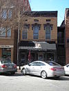
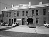
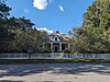
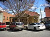
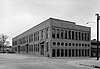
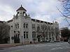
[2] Name on the Register Image Date listed [3] Location City or town Description 1 1238 Professional Building Upload image July 1, 2022 (# 100007851 1238 2nd Ave. 32°28′13″N 84°59′25″W / 32.4702°N 84.9903°W / 32.4702; -84.9903 (1238 Professional Building ) Columbus 2 Adams Cotton Gin Building Adams Cotton Gin Building May 17, 1984 (# 84001205 6601 Hamilton Rd. 32°32′26″N 84°57′18″W / 32.540556°N 84.955°W / 32.540556; -84.955 (Adams Cotton Gin Building ) Columbus Removed between 2008 and 2009 3 George O. Berry House Upload image September 29, 1980 (# 80001124 912 2nd Ave. 32°27′48″N 84°59′24″W / 32.463458°N 84.990026°W / 32.463458; -84.990026 (George O. Berry House ) Columbus 4 Bibb City Historic District Upload image February 24, 2010 (# 10000037 Roughly bounded by Chattahoochee River, Woodland Cir., 2nd Ave. and 35th St. 32°30′08″N 84°59′30″W / 32.502347°N 84.991686°W / 32.502347; -84.991686 (Bibb City Historic District ) Bibb City 5 Broad Street Methodist Episcopal Church South Upload image December 2, 1980 (# 80001125 1323-1325 Broadway 32°28′17″N 84°59′37″W / 32.471389°N 84.993611°W / 32.471389; -84.993611 (Broad Street Methodist Episcopal Church South ) Columbus Removed 6 Building at 1007 Broadway Building at 1007 Broadway September 29, 1980 (# 80001130 1007 Broadway 32°27′55″N 84°59′37″W / 32.465145°N 84.993619°W / 32.465145; -84.993619 (Building at 1007 Broadway ) Columbus 7 Building at 1009 Broadway Building at 1009 Broadway September 29, 1980 (# 80001131 1009 Broadway 32°27′55″N 84°59′37″W / 32.465236°N 84.993563°W / 32.465236; -84.993563 (Building at 1009 Broadway ) Columbus 8 Building at 1400 Third Avenue Building at 1400 Third Avenue September 29, 1980 (# 80001132 1400 Third Ave. 32°28′21″N 84°59′20″W / 32.4725°N 84.988889°W / 32.4725; -84.988889 (Building at 1400 Third Avenue ) Columbus 9 Building at 1519 3rd Avenue Upload image December 2, 1980 (# 80001126 1519 3rd Ave. 32°28′30″N 84°59′21″W / 32.475°N 84.989167°W / 32.475; -84.989167 (Building at 1519 3rd Avenue ) Columbus Removed 10 Building at 1531 3rd Avenue Upload image December 2, 1980 (# 80001127 1531 3rd Ave. 32°28′32″N 84°59′21″W / 32.475536°N 84.989276°W / 32.475536; -84.989276 (Building at 1531 3rd Avenue ) Columbus 11 Building at 1612 3rd Avenue Upload image December 2, 1980 (# 80001128 1612 3rd Ave. 32°28′35″N 84°59′20″W / 32.476389°N 84.988889°W / 32.476389; -84.988889 (Building at 1612 3rd Avenue ) Columbus Removed 12 Building at 1617 Third Avenue Upload image September 29, 1980 (# 80001137 1617 Third Ave. 32°28′37″N 84°59′21″W / 32.477037°N 84.989247°W / 32.477037; -84.989247 (Building at 1617 Third Avenue ) Columbus 13 Building at 1619 Third Avenue Upload image September 29, 1980 (# 80001138 1619 Third Ave. 32°28′38″N 84°59′21″W / 32.477112°N 84.989264°W / 32.477112; -84.989264 (Building at 1619 Third Avenue ) Columbus 14 Building at 1625 Third Avenue Upload image September 29, 1980 (# 80001139 1625 Third Ave. 32°28′38″N 84°59′21″W / 32.477220°N 84.989281°W / 32.477220; -84.989281 (Building at 1625 Third Avenue ) Columbus 15 Building at 215 Ninth Street Upload image September 29, 1980 (# 80001140 215 Ninth St. 32°27′47″N 84°59′22″W / 32.463086°N 84.989578°W / 32.463086; -84.989578 (Building at 215 Ninth Street ) Columbus 16 Building at 221 Ninth Street Upload image September 29, 1980 (# 80001141 221 Ninth St. 32°27′47″N 84°59′22″W / 32.463078°N 84.989334°W / 32.463078; -84.989334 (Building at 221 Ninth Street ) Columbus 17 Building at 303 11th St. Upload image December 2, 1980 (# 80001129 303 11th St. 32°28′00″N 84°59′20″W / 32.466667°N 84.988889°W / 32.466667; -84.988889 (Building at 303 11th St. ) Columbus Removed 18 Building at 920 Ninth Avenue Upload image September 29, 1980 (# 80001142 920 Ninth Ave. 32°27′45″N 84°58′48″W / 32.462471°N 84.980088°W / 32.462471; -84.980088 (Building at 920 Ninth Avenue ) Columbus 19 Building at 921 Fifth Avenue Upload image September 29, 1980 (# 80001143 921 Fifth Ave. 32°27′50″N 84°59′12″W / 32.463934°N 84.986603°W / 32.463934; -84.986603 (Building at 921 Fifth Avenue ) Columbus 20 Building at 944 Second Avenue Upload image September 29, 1980 (# 80001144 944 Second Ave. 32°27′52″N 84°59′25″W / 32.464444°N 84.990278°W / 32.464444; -84.990278 (Building at 944 Second Avenue ) Columbus Removed 21 Bullard-Hart House Bullard-Hart House July 28, 1977 (# 77000439 1408 3rd Ave. 32°28′23″N 84°59′20″W / 32.473056°N 84.988889°W / 32.473056; -84.988889 (Bullard-Hart House ) Columbus 22 Bush-Philips Hardware Co. Bush-Philips Hardware Co. December 2, 1980 (# 80001145 1025 Broadway 32°27′56″N 84°59′37″W / 32.465556°N 84.993611°W / 32.465556; -84.993611 (Bush-Philips Hardware Co. ) Columbus 23 Thomas U. Butts House Thomas U. Butts House September 29, 1980 (# 80001146 1214 3rd Ave. 32°28′09″N 84°59′20″W / 32.469167°N 84.988889°W / 32.469167; -84.988889 (Thomas U. Butts House ) Columbus 24 C.S.S. Muscogee and Chattahoochee (gunboats) C.S.S. Muscogee and Chattahoochee (gunboats) May 13, 1970 (# 70000212 4th St. W of U.S. 27 32°26′49″N 84°58′46″W / 32.446851°N 84.979511°W / 32.446851; -84.979511 (C.S.S. Muscogee and Chattahoochee (gunboats) ) Columbus CSS Chattahoochee and CSS Muscogee 25 Walter Hurt Cargill House Upload image September 29, 1980 (# 80001147 1415 3rd Ave. 32°28′22″N 84°59′22″W / 32.472778°N 84.989444°W / 32.472778; -84.989444 (Walter Hurt Cargill House ) Columbus 26 Carter and Bradley, Cotton Factors and Warehouseman Carter and Bradley, Cotton Factors and Warehouseman December 2, 1980 (# 80001148 1001-1037 Front Ave. 32°27′56″N 84°59′42″W / 32.465556°N 84.995°W / 32.465556; -84.995 (Carter and Bradley, Cotton Factors and Warehouseman ) Columbus 27 The Cedars The Cedars November 23, 1971 (# 71000282 2039 13th St. 32°28′20″N 84°57′48″W / 32.472222°N 84.963333°W / 32.472222; -84.963333 (The Cedars ) Columbus 28 Central of Georgia Railroad Terminal Upload image December 2, 1980 (# 80001150 700 12th St. 32°28′07″N 84°59′01″W / 32.468611°N 84.983611°W / 32.468611; -84.983611 (Central of Georgia Railroad Terminal ) Columbus Removed 29 Central of Georgia Railroad Terminal Central of Georgia Railroad Terminal September 29, 1980 (# 80001149 1200 6th Ave. 32°28′07″N 84°59′01″W / 32.468611°N 84.983611°W / 32.468611; -84.983611 (Central of Georgia Railroad Terminal ) Columbus 30 Church of the Holy Family Church of the Holy Family September 29, 1980 (# 80001152 320 12th St. 32°28′06″N 84°59′18″W / 32.468333°N 84.988333°W / 32.468333; -84.988333 (Church of the Holy Family ) Columbus 31 Church Square Upload image December 2, 1980 (# 80001151 Roughly bounded by 2nd and 3rd Aves., 11th and 12th Sts. 32°28′03″N 84°59′23″W / 32.4675°N 84.989722°W / 32.4675; -84.989722 (Church Square ) Columbus 32 City Fire Department City Fire Department September 29, 1980 (# 80001153 1338 and 1340 Broadway 32°28′19″N 84°59′35″W / 32.471944°N 84.993056°W / 32.471944; -84.993056 (City Fire Department ) Columbus 33 Claflin School Upload image November 24, 2015 (# 15000813 1532 5th Ave. 32°28′33″N 84°59′07″W / 32.4757°N 84.9854°W / 32.4757; -84.9854 (Claflin School ) Columbus 34 Cole-Hatcher-Hampton Wholesale Grocers Upload image September 29, 1980 (# 80001154 22 W. 10 St. 32°27′54″N 84°59′40″W / 32.465009°N 84.994326°W / 32.465009; -84.994326 (Cole-Hatcher-Hampton Wholesale Grocers ) Columbus 35 Colored Cemetery aka Porterdale Cemetery Upload image September 29, 1980 (# 80001155 10th Ave. 32°27′11″N 84°58′54″W / 32.453056°N 84.981667°W / 32.453056; -84.981667 (Colored Cemetery aka Porterdale Cemetery ) Columbus 36 Columbian Lodge No. 7 Free and Accepted Masons Upload image September 29, 1980 (# 80001156 101 12th St. 32°28′07″N 84°59′30″W / 32.468611°N 84.991667°W / 32.468611; -84.991667 (Columbian Lodge No. 7 Free and Accepted Masons ) Columbus 37 Columbus Coca-Cola Bottling Company Upload image August 22, 2022 (# 100008016 1147 6th Ave. 32°28′04″N 84°59′06″W / 32.4679°N 84.9850°W / 32.4679; -84.9850 (Columbus Coca-Cola Bottling Company ) Columbus 38 Columbus High School Upload image September 29, 1980 (# 80001157 320 11th St. 32°27′59″N 84°59′17″W / 32.466389°N 84.988056°W / 32.466389; -84.988056 (Columbus High School ) Columbus Columbus High School no longer occupies building 39 Columbus Historic District Columbus Historic District July 29, 1969 (# 69000045 Roughly bounded by 9th and 4th Sts., 4th Ave., and the Chattahoochee RiverOctober 21, 1988 , refnum 88002048): Bounded by Ninth and Fourth Sts., Chattahoochee River and Fourth Ave. 32°27′29″N 84°59′32″W / 32.458056°N 84.992222°W / 32.458056; -84.992222 (Columbus Historic District ) Columbus 40 Columbus Historic Riverfront Industrial District Columbus Historic Riverfront Industrial District June 2, 1978 (# 78000995 Columbus River from 8th St. N. to 38th St. 32°29′08″N 84°59′31″W / 32.485553°N 84.992017°W / 32.485553; -84.992017 (Columbus Historic Riverfront Industrial District ) Columbus National Historic Landmark 41 Columbus Investment Company Building Upload image September 29, 1980 (# 80001158 21 12th St. 32°28′07″N 84°59′32″W / 32.468611°N 84.992222°W / 32.468611; -84.992222 (Columbus Investment Company Building ) Columbus 42 Columbus Ironworks Columbus Ironworks July 29, 1969 (# 69000046 901 Front Ave. 32°27′47″N 84°59′43″W / 32.463056°N 84.995278°W / 32.463056; -84.995278 (Columbus Ironworks ) Columbus 43 Columbus Manufacturing Company Columbus Manufacturing Company July 10, 2007 (# 07000699 3201 1st Ave. 32°29′40″N 84°59′29″W / 32.49435°N 84.991297°W / 32.49435; -84.991297 (Columbus Manufacturing Company ) Columbus 44 Columbus Stockade Upload image December 2, 1980 (# 80001159 622 10th St. 32°27′52″N 84°59′02″W / 32.464444°N 84.983889°W / 32.464444; -84.983889 (Columbus Stockade ) Columbus 45 Wm. L. Cooke House Upload image December 2, 1980 (# 80001210 1523 3rd Ave. 32°28′31″N 84°59′21″W / 32.475278°N 84.989167°W / 32.475278; -84.989167 (Wm. L. Cooke House ) Columbus 46 William H. Denson House William H. Denson House September 29, 1980 (# 80001162 930 5th Ave. 32°27′50″N 84°59′10″W / 32.463889°N 84.986111°W / 32.463889; -84.986111 (William H. Denson House ) Columbus Removed 47 Depot Business Buildings Upload image September 29, 1980 (# 80001163 519, 521 and 523 E. 12th St. 32°28′08″N 84°59′06″W / 32.468804°N 84.985116°W / 32.468804; -84.985116 (Depot Business Buildings ) Columbus 48 Dinglewood Dinglewood February 1, 1972 (# 72000389 1429 Dinglewood St. 32°28′07″N 84°58′19″W / 32.468611°N 84.971944°W / 32.468611; -84.971944 (Dinglewood ) Columbus An Italian Villa style house built in 1859 49 Dinglewood Historic District Dinglewood Historic District November 21, 2001 (# 01001248 Bounded by 13th and 16th Ave., 13th St., and Wynnton Rd. 32°28′08″N 84°58′14″W / 32.468753°N 84.970486°W / 32.468753; -84.970486 (Dinglewood Historic District ) Columbus A historic district 50 Robert E. Dismukes Sr. House Robert E. Dismukes Sr. House January 8, 1979 (# 79000736 1617 Summit Dr. 32°28′34″N 84°57′46″W / 32.476111°N 84.962778°W / 32.476111; -84.962778 (Robert E. Dismukes Sr. House ) Columbus 51 Elisha P. Dismukes House Upload image December 2, 1980 (# 80001164 1515 3rd Ave. 32°28′29″N 84°59′21″W / 32.474722°N 84.989167°W / 32.474722; -84.989167 (Elisha P. Dismukes House ) Columbus Lost to fire 52 First African Baptist Church First African Baptist Church September 29, 1980 (# 80001165 901 5th Ave. 32°27′46″N 84°59′12″W / 32.462778°N 84.986667°W / 32.462778; -84.986667 (First African Baptist Church ) Columbus 53 First African Baptist Church Parsonage First African Baptist Church Parsonage September 29, 1980 (# 80001166 911 5th Ave. 32°27′47″N 84°59′12″W / 32.463056°N 84.986667°W / 32.463056; -84.986667 (First African Baptist Church Parsonage ) Columbus 54 First National Bank First National Bank November 1, 1974 (# 74000697 1048 Broadway 32°27′59″N 84°59′34″W / 32.466527°N 84.992877°W / 32.466527; -84.992877 (First National Bank ) Columbus 55 First Presbyterian Church First Presbyterian Church September 29, 1980 (# 80001167 1100 1st Ave. 32°28′00″N 84°59′30″W / 32.466667°N 84.991667°W / 32.466667; -84.991667 (First Presbyterian Church ) Columbus 56 John T. Fletcher House Upload image September 29, 1980 (# 80001168 311 11th St. 32°28′00″N 84°59′19″W / 32.466667°N 84.988611°W / 32.466667; -84.988611 (John T. Fletcher House ) Columbus Removed 57 Fontaine Building Upload image September 29, 1980 (# 80001169 13 W. 11th St. 32°27′59″N 84°59′39″W / 32.466389°N 84.994167°W / 32.466389; -84.994167 (Fontaine Building ) Columbus 58 Fortson House Fortson House June 3, 1999 (# 99000657 1100 Fortson Rd. 32°36′24″N 84°56′07″W / 32.6067966°N 84.935203°W / 32.6067966; -84.935203 (Fortson House ) Fortson 59 Frank Brothers Upload image December 2, 1980 (# 80001170 18 W. 10th St. 32°27′54″N 84°59′39″W / 32.464981°N 84.994202°W / 32.464981; -84.994202 (Frank Brothers ) Columbus 60 Gann's Pharmacy Upload image September 29, 1980 (# 80001171 1611 2nd Ave. 32°28′36″N 84°59′26″W / 32.476667°N 84.990556°W / 32.476667; -84.990556 (Gann's Pharmacy ) Columbus Removed 61 Garrett-Bullock House Upload image September 29, 1980 (# 80001172 1402 2nd Ave. 32°28′21″N 84°59′25″W / 32.4725°N 84.990278°W / 32.4725; -84.990278 (Garrett-Bullock House ) Columbus 62 Girard Colored Mission Upload image September 29, 1980 (# 80001173 1002 6th Ave. 32°27′55″N 84°59′04″W / 32.465348°N 84.984527°W / 32.465348; -84.984527 (Girard Colored Mission ) Columbus 63 Goetchius-Wellborn House Goetchius-Wellborn House July 29, 1969 (# 69000047 405 Broadway 32°27′14″N 84°59′38″W / 32.453889°N 84.993889°W / 32.453889; -84.993889 (Goetchius-Wellborn House ) Columbus 64 Golden Brothers, Founders and Machinists Upload image September 29, 1980 (# 80001174 600 12th St. 32°28′04″N 84°59′05″W / 32.467778°N 84.984722°W / 32.467778; -84.984722 (Golden Brothers, Founders and Machinists ) Columbus 65 Green Island Ranch Upload image February 7, 1997 (# 97000030 6551 Green Island Dr. 32°32′31″N 85°00′11″W / 32.541944°N 85.003056°W / 32.541944; -85.003056 (Green Island Ranch ) Columbus 66 Harrison-Gibson House Upload image September 29, 1980 (# 80001175 309 11th St. 32°28′00″N 84°59′19″W / 32.466667°N 84.988611°W / 32.466667; -84.988611 (Harrison-Gibson House ) Columbus Removed 67 High Uptown Historic District Upload image July 7, 2004 (# 04000669 Roughly bounded by 2nd and 3rd Aves. between Railroad and 13th Sts. 32°28′25″N 84°59′22″W / 32.473611°N 84.989444°W / 32.473611; -84.989444 (High Uptown Historic District ) Columbus 68 Highland Hall Upload image April 1, 1980 (# 80004459 1504 17th St. 32°28′42″N 84°58′12″W / 32.478275°N 84.969904°W / 32.478275; -84.969904 (Highland Hall ) Columbus 69 Hillcrest-Wildwood Circle Historic District Upload image July 14, 2002 (# 02001748 Roughly bounded by Wildwood Ave., 13th and 17th Sts., and Dixon Dr. 32°28′31″N 84°57′21″W / 32.475278°N 84.955833°W / 32.475278; -84.955833 (Hillcrest-Wildwood Circle Historic District ) Columbus 70 Hilton Hilton January 20, 1972 (# 72000390 2505 Macon Rd. 32°28′24″N 84°57′14″W / 32.473333°N 84.953889°W / 32.473333; -84.953889 (Hilton ) Columbus 71 Hofflin & Greentree Building Hofflin & Greentree Building September 30, 1982 (# 82002457 1128-1130 Broadway 32°28′04″N 84°59′35″W / 32.467778°N 84.993056°W / 32.467778; -84.993056 (Hofflin & Greentree Building ) Columbus 72 Illges House Upload image June 19, 1973 (# 73000634 1428 2nd Ave. 32°28′25″N 84°59′24″W / 32.473584°N 84.989928°W / 32.473584; -84.989928 (Illges House ) Columbus 73 John Paul Illges House John Paul Illges House September 29, 1980 (# 80001178 1425 3rd Ave. 32°28′24″N 84°59′21″W / 32.473333°N 84.989167°W / 32.473333; -84.989167 (John Paul Illges House ) Columbus 74 Isaac Maund House Upload image December 2, 1980 (# 80001179 1608 3rd Ave. 32°28′35″N 84°59′20″W / 32.476389°N 84.988889°W / 32.476389; -84.988889 (Isaac Maund House ) Columbus Home no longer exists. 75 Joseph House Joseph House July 29, 1969 (# 69000048 828 Broadway 32°27′44″N 84°59′35″W / 32.462222°N 84.993056°W / 32.462222; -84.993056 (Joseph House ) Columbus 76 Kress Kress September 29, 1980 (# 80001180 1117 Broadway 32°28′02″N 84°59′37″W / 32.467222°N 84.993611°W / 32.467222; -84.993611 (Kress ) Columbus Building destroyed by fire in 1994. Facade was saved and remains standing. 77 Abraham Lafkowitz House Upload image September 29, 1980 (# 80001181 934 5th Ave. 32°27′51″N 84°59′10″W / 32.464167°N 84.986111°W / 32.464167; -84.986111 (Abraham Lafkowitz House ) Columbus Removed 78 Ledger-Enquirer Building Ledger-Enquirer Building December 2, 1980 (# 80001183 17 W. 12th St. 32°28′06″N 84°59′40″W / 32.468333°N 84.994444°W / 32.468333; -84.994444 (Ledger-Enquirer Building ) Columbus 79 Lewis-Rothchild Building Upload image March 26, 2004 (# 04000239 1214 First Ave. 32°28′08″N 84°59′30″W / 32.468889°N 84.991667°W / 32.468889; -84.991667 (Lewis-Rothchild Building ) Columbus 80 Liberty Theater Liberty Theater May 22, 1984 (# 84001208 821 8th Ave. 32°27′42″N 84°58′58″W / 32.461667°N 84.982778°W / 32.461667; -84.982778 (Liberty Theater ) Columbus 81 Lion House Lion House January 20, 1972 (# 72000391 1316 3rd Ave. 32°28′16″N 84°59′22″W / 32.471111°N 84.989444°W / 32.471111; -84.989444 (Lion House ) Columbus 82 Sol Loeb Building-Garrett-Joy Building Sol Loeb Building-Garrett-Joy Building March 15, 2005 (# 05000141 900 Front Ave. and 901 Broadway 32°27′46″N 84°59′37″W / 32.462778°N 84.993611°W / 32.462778; -84.993611 (Sol Loeb Building-Garrett-Joy Building ) Muscogee 83 McArdle House McArdle House September 29, 1980 (# 80001184 927 3rd Ave. 32°27′49″N 84°59′22″W / 32.463611°N 84.989444°W / 32.463611; -84.989444 (McArdle House ) Columbus 84 McGehee-Woodall House Upload image January 20, 1972 (# 72000392 1534 2nd Ave. 32°28′33″N 84°59′26″W / 32.475833°N 84.990556°W / 32.475833; -84.990556 (McGehee-Woodall House ) Columbus Removed 85 Methodist Tabernacle Upload image September 29, 1980 (# 80001186 1605 3rd Ave. 32°28′34″N 84°59′22″W / 32.476111°N 84.989444°W / 32.476111; -84.989444 (Methodist Tabernacle ) Columbus 86 Mott House Mott House December 3, 1974 (# 74000698 Front Ave. 32°28′22″N 84°59′39″W / 32.472778°N 84.994167°W / 32.472778; -84.994167 (Mott House ) Columbus Destroyed by fire September 8, 2014. 87 Mott--Fox--Huguley House Upload image March 12, 2012 (# 12000093 2027 6th Avenue 32°29′03″N 84°59′09″W / 32.484131°N 84.985948°W / 32.484131; -84.985948 (Mott--Fox--Huguley House ) Columbus 88 Octagon House Octagon House July 29, 1969 (# 69000049 527 1st Ave. 32°27′23″N 84°59′32″W / 32.4562674°N 84.992257°W / 32.4562674; -84.992257 (Octagon House ) Columbus National Historic Landmark 89 Old City Cemetery Old City Cemetery September 29, 1980 (# 80001188 Linwood Blvd. 32°28′39″N 84°59′00″W / 32.4775°N 84.983333°W / 32.4775; -84.983333 (Old City Cemetery ) Columbus 90 Old Dawson Place Upload image January 8, 1979 (# 79000737 1420 Wynnton Rd. 32°27′59″N 84°58′17″W / 32.4663885°N 84.971461°W / 32.4663885; -84.971461 (Old Dawson Place ) Columbus 91 Peabody-Warner House Peabody-Warner House December 29, 1970 (# 70000213 1445 2nd Ave. 32°28′26″N 84°59′27″W / 32.473889°N 84.990833°W / 32.473889; -84.990833 (Peabody-Warner House ) Columbus 92 Peacock Woods-Dimon Circle Historic District Upload image March 26, 2003 (# 03000134 Bounded by Cherokee and Forest Aves. and 13th and 17 Sts. 32°28′31″N 84°57′47″W / 32.475278°N 84.963056°W / 32.475278; -84.963056 (Peacock Woods-Dimon Circle Historic District ) Columbus 93 Pemberton House Pemberton House September 28, 1971 (# 71000283 11 7th St. 32°27′33″N 84°59′34″W / 32.459167°N 84.992778°W / 32.459167; -84.992778 (Pemberton House ) Columbus 94 George Phillips House Upload image September 29, 1980 (# 80001190 1406 3rd Ave. 32°28′22″N 84°59′20″W / 32.472778°N 84.988889°W / 32.472778; -84.988889 (George Phillips House ) Columbus 95 George Pond House George Pond House September 29, 1980 (# 80001191 922 2nd Ave. 32°27′49″N 84°59′26″W / 32.463611°N 84.990556°W / 32.463611; -84.990556 (George Pond House ) Columbus 96 Power and Baird, Wholesale Dry Goods and Notions Upload image December 2, 1980 (# 80001193 1107 Broadway 32°28′01″N 84°59′37″W / 32.466944°N 84.993611°W / 32.466944; -84.993611 (Power and Baird, Wholesale Dry Goods and Notions ) Columbus 97 Gertrude Ma Pridgett Rainey House Gertrude Ma Pridgett Rainey House November 18, 1992 (# 92001530 805 5th Ave. 32°27′41″N 84°59′12″W / 32.461389°N 84.986667°W / 32.461389; -84.986667 (Gertrude Ma Pridgett Rainey House ) Columbus 98 Rankin House Rankin House March 16, 1972 (# 72000393 1440 2nd Ave. 32°28′20″N 84°59′25″W / 32.472222°N 84.990278°W / 32.472222; -84.990278 (Rankin House ) Columbus 99 Rankin Square Upload image October 7, 1977 (# 77000440 Bounded by Broadway, 1st Ave., 10th and 11th Sts. 32°27′56″N 84°59′34″W / 32.465556°N 84.992778°W / 32.465556; -84.992778 (Rankin Square ) Columbus 100 Reich Dry Goods Company Upload image April 1, 2004 (# 04000240 14 W 11th St. 32°28′01″N 84°59′39″W / 32.466884°N 84.994074°W / 32.466884; -84.994074 (Reich Dry Goods Company ) Columbus 101 Ridgewood Upload image April 2, 1980 (# 80001215 Jenkins Rd. 32°33′19″N 84°44′26″W / 32.555278°N 84.740556°W / 32.555278; -84.740556 (Ridgewood ) Upatoi 102 John Spencer Roberts House Upload image September 29, 1980 (# 80001195 927 5th Ave. 32°27′50″N 84°59′12″W / 32.463889°N 84.986667°W / 32.463889; -84.986667 (John Spencer Roberts House ) Columbus 103 Rose Hill School Upload image March 30, 2022 (# 100007533 433 21st St. 32°29′04″N 84°59′10″W / 32.4844°N 84.9861°W / 32.4844; -84.9861 (Rose Hill School ) Columbus 104 Max Rosenberg House Upload image September 29, 1980 (# 80001196 1011 3rd Ave. 32°27′54″N 84°59′22″W / 32.465°N 84.989444°W / 32.465; -84.989444 (Max Rosenberg House ) Columbus 105 David Rothschild's Wholesale Dry Goods Upload image September 29, 1980 (# 80001197 1029 Broadway 32°27′57″N 84°59′37″W / 32.465833°N 84.993611°W / 32.465833; -84.993611 (David Rothschild's Wholesale Dry Goods ) Columbus 106 David Rothschild House Upload image September 29, 1980 (# 80001198 1220 3rd Ave. 32°28′10″N 84°59′20″W / 32.469444°N 84.988889°W / 32.469444; -84.988889 (David Rothschild House ) Columbus Removed 107 Secondary Industrial School Secondary Industrial School April 9, 1980 (# 80001199 1112 29th St. 32°29′21″N 84°58′41″W / 32.489167°N 84.978056°W / 32.489167; -84.978056 (Secondary Industrial School ) Columbus 108 Silver's Five and Dime Store-H.L. Green Co. Upload image August 4, 2005 (# 05000794 1101-1103 Broadway 32°28′01″N 84°59′37″W / 32.4668782°N 84.99372°W / 32.4668782; -84.99372 (Silver's Five and Dime Store-H.L. Green Co. ) Columbus 109 Sixteenth Street School Upload image September 29, 1980 (# 80001200 1532 3rd Ave. 32°28′33″N 84°59′20″W / 32.475833°N 84.988889°W / 32.475833; -84.988889 (Sixteenth Street School ) Columbus 110 Southern Railway Freight Depot Upload image August 21, 1997 (# 97000922 1300 6th Ave. 32°28′17″N 84°59′05″W / 32.471389°N 84.984722°W / 32.471389; -84.984722 (Southern Railway Freight Depot ) Columbus 111 William Henry Spencer House Upload image May 23, 1978 (# 78000996 745 4th Ave. 32°27′39″N 84°59′17″W / 32.46074°N 84.98798°W / 32.46074; -84.98798 (William Henry Spencer House ) Columbus 112 Springer Opera House Springer Opera House December 29, 1970 (# 70000214 105 10th St. 32°27′54″N 84°59′29″W / 32.46513°N 84.99134°W / 32.46513; -84.99134 (Springer Opera House ) Columbus National Historic Landmark 113 St. Christoper's Normal and Industrial Parish School St. Christoper's Normal and Industrial Parish School September 29, 1980 (# 80001201 900 5th Ave. 32°27′46″N 84°59′10″W / 32.462778°N 84.986111°W / 32.462778; -84.986111 (St. Christoper's Normal and Industrial Parish School ) Columbus Removed 114 St. Elmo St. Elmo April 7, 1971 (# 71000284 2810 St. Elmo Dr. 32°29′21″N 84°57′58″W / 32.489167°N 84.966111°W / 32.489167; -84.966111 (St. Elmo ) Columbus 115 St. John Chapel St. John Chapel September 29, 1980 (# 80001202 1516 5th Ave. 32°28′29″N 84°59′10″W / 32.474722°N 84.986111°W / 32.474722; -84.986111 (St. John Chapel ) Columbus 116 Swift Manufacturing Company Upload image September 10, 2014 (# 14000173 1410 6th St. 32°28′27″N 84°59′04″W / 32.4740569°N 84.984432°W / 32.4740569; -84.984432 (Swift Manufacturing Company ) Columbus 117 Swift-Kyle House Swift-Kyle House April 11, 1973 (# 73000635 303 12th St. 32°28′09″N 84°59′20″W / 32.469167°N 84.988889°W / 32.469167; -84.988889 (Swift-Kyle House ) Columbus 118 C. B. Tarver Building Upload image August 4, 2005 (# 05000793 18-23 W. 11th St. 32°28′01″N 84°59′40″W / 32.4668662°N 84.994322°W / 32.4668662; -84.994322 (C. B. Tarver Building ) Columbus 119 Alma Thomas House Alma Thomas House October 20, 2009 (# 09000270 411 21st St. 32°29′04″N 84°59′13″W / 32.484386°N 84.986967°W / 32.484386; -84.986967 (Alma Thomas House ) Columbus 120 Triangle Building Triangle Building September 29, 1980 (# 80001204 1330 Broadway 32°28′17″N 84°59′35″W / 32.471389°N 84.993056°W / 32.471389; -84.993056 (Triangle Building ) Columbus Removed 121 Trinity Episcopal Church Trinity Episcopal Church September 29, 1980 (# 80001205 1130 1st Ave. 32°28′03″N 84°59′30″W / 32.4675°N 84.991667°W / 32.4675; -84.991667 (Trinity Episcopal Church ) Columbus 122 Charles E. Turner House Upload image September 29, 1980 (# 80001206 909 3rd Ave. 32°27′48″N 84°59′22″W / 32.463333°N 84.989444°W / 32.463333; -84.989444 (Charles E. Turner House ) Columbus 123 U.S. Post Office and Courthouse U.S. Post Office and Courthouse September 29, 1980 (# 80001207 120 12th St. 32°28′06″N 84°59′27″W / 32.468333°N 84.990833°W / 32.468333; -84.990833 (U.S. Post Office and Courthouse ) Columbus 124 W. Jacob Burrus House Upload image December 2, 1980 (# 80001208 307 11th St. 32°28′00″N 84°59′20″W / 32.466667°N 84.988889°W / 32.466667; -84.988889 (W. Jacob Burrus House ) Columbus Removed 125 Walker-Peters-Langdon House Walker-Peters-Langdon House July 29, 1969 (# 69000050 716 Broadway 32°27′36″N 84°59′41″W / 32.46°N 84.994722°W / 32.46; -84.994722 (Walker-Peters-Langdon House ) Columbus 126 Waverly Terrace Upload image December 1, 1983 (# 83003598 Roughly bounded by Hamilton Rd., Peabody Ave., 27th and 30th Sts. 32°29′23″N 84°58′44″W / 32.489722°N 84.978889°W / 32.489722; -84.978889 (Waverly Terrace ) Columbus 127 Wells-Bagley House Upload image July 29, 1969 (# 69000051 22 6th St. 32°27′25″N 84°59′32″W / 32.456908°N 84.992201°W / 32.456908; -84.992201 (Wells-Bagley House ) Columbus 128 Weracoba-St. Elmo Historic District Weracoba-St. Elmo Historic District July 1, 1994 (# 94000665 Roughly bounded by 13th and Virginia Sts., 13th, 15th, 16th and Cherokee Aves. and Talbotton Rd. 32°28′51″N 84°58′05″W / 32.480833°N 84.968056°W / 32.480833; -84.968056 (Weracoba-St. Elmo Historic District ) Muscogee 129 Wolfson Printing and Paper Co. Upload image December 2, 1980 (# 80001211 24 W. 10th St. 32°27′54″N 84°59′40″W / 32.464959°N 84.99444°W / 32.464959; -84.99444 (Wolfson Printing and Paper Co. ) Columbus 130 Ernest Woodruff House Upload image September 29, 1980 (# 80001212 1414 2nd Ave. 32°28′22″N 84°59′25″W / 32.472778°N 84.990278°W / 32.472778; -84.990278 (Ernest Woodruff House ) Columbus 131 Henry Lindsay Woodruff House Upload image December 2, 1980 (# 80001176 1535 3rd Ave. 32°28′32″N 84°59′21″W / 32.475556°N 84.989167°W / 32.475556; -84.989167 (Henry Lindsay Woodruff House ) Columbus 132 Henry Lindsay Woodruff Second House Upload image September 29, 1980 (# 80001213 1420 2nd Ave. 32°28′23″N 84°59′25″W / 32.473056°N 84.990278°W / 32.473056; -84.990278 (Henry Lindsay Woodruff Second House ) Columbus 133 John W. Woolfolk House Upload image January 22, 1979 (# 79000738 1615 12th St. 32°28′07″N 84°58′06″W / 32.468611°N 84.968333°W / 32.468611; -84.968333 (John W. Woolfolk House ) Columbus 134 Wynn House Upload image February 1, 1972 (# 72000394 1240 Wynnton Rd. 32°27′57″N 84°58′28″W / 32.465833°N 84.974444°W / 32.465833; -84.974444 (Wynn House ) Columbus 135 Wynn's Hill-Overlook-Oak Circle Historic District Upload image May 10, 2005 (# 05000403 Roughly bounded by Bradley Rd., Buena Vista Rd., Overlook Ave., Crest Dr., and Oakview Ave. 32°27′53″N 84°58′14″W / 32.464722°N 84.970556°W / 32.464722; -84.970556 (Wynn's Hill-Overlook-Oak Circle Historic District ) Columbus 136 Wynnton Academy Wynnton Academy April 11, 1972 (# 72000395 2303 Wynnton Rd. 32°28′16″N 84°57′31″W / 32.4710972°N 84.958660°W / 32.4710972; -84.958660 (Wynnton Academy ) Columbus 137 Wynnton Village Historic District Upload image June 22, 2005 (# 05000622 Roughly bounded by Wildwood Ave., Forest Ave., 18th St., 13th St., 16th ave. Wynnton Rd. 32°28′22″N 84°57′49″W / 32.472778°N 84.963611°W / 32.472778; -84.963611 (Wynnton Village Historic District ) Columbus 138 Wynnwood Wynnwood January 20, 1972 (# 72000396 1846 Buena Vista Rd. 32°27′56″N 84°57′57″W / 32.465556°N 84.965833°W / 32.465556; -84.965833 (Wynnwood ) Columbus Also known as "The Elms" 139 Y.M.C.A. Upload image September 29, 1980 (# 80001214 124 11th St. 32°27′59″N 84°59′27″W / 32.466389°N 84.990833°W / 32.466389; -84.990833 (Y.M.C.A. ) Columbus