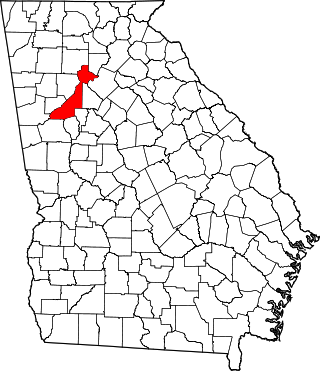
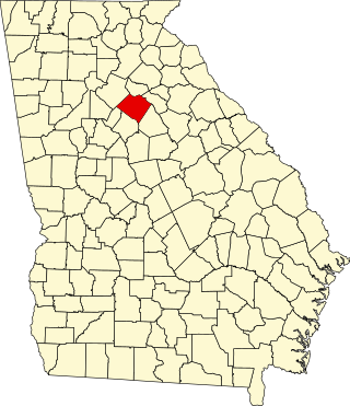
This is a list of properties and districts in DeKalb County, Georgia that are listed on the National Register of Historic Places (NRHP).
Contents
This National Park Service list is complete through NPS recent listings posted July 28, 2023. [1]
This is a list of properties and districts in DeKalb County, Georgia that are listed on the National Register of Historic Places (NRHP).
This National Park Service list is complete through NPS recent listings posted July 28, 2023. [1]
| [2] | Name on the Register | Image | Date listed [3] | Location | City or town | Description |
|---|---|---|---|---|---|---|
| 1 | Robert A. Alston House | 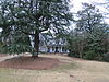 | July 14, 2004 (#04000683) | 2420 Alston Dr., SE, off Eastlake Rd. 33°44′44″N84°18′27″W / 33.745587°N 84.30753°W | Atlanta | Meadow Nook , one of the few extant antebellum homes in Atlanta in its original location |
| 2 | Avondale Estates Historic District | 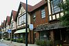 | December 8, 1986 (#86003669) | Roughly bounded by Avondale Rd., Lakeshore Dr., Kingstone, Clarendon, and Fairchild Dr., also Lake Avondale 33°46′19″N84°16′04″W / 33.771944°N 84.267778°W | Avondale Estates | |
| 3 | Blair-Rutland Building |  | December 12, 2002 (#02001492) | 215 Church St. 33°46′25″N84°17′40″W / 33.773611°N 84.294444°W | Decatur | |
| 4 | Bond Family House | 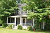 | September 17, 2008 (#08000909) | 1226 Rock Chapel Rd. 33°45′21″N84°04′51″W / 33.755828°N 84.080811°W | Lithonia | |
| 5 | Briarcliff |  | August 4, 1988 (#88001167) | 1260 Briarcliff Rd., NE 33°47′22″N84°20′27″W / 33.789444°N 84.340833°W | Atlanta | |
| 6 | Briarcliff-Normandy Apartments |  | March 26, 2003 (#03000136) | Roughly along Briarcliff Rd., Normandy Dr. and Chalmette Dr. 33°47′18″N84°20′31″W / 33.788333°N 84.341944°W | Atlanta | |
| 7 | Brookhaven Historic District | 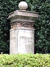 | January 24, 1986 (#86000134) | E of Peachtree-Dunwoody and N and E of Peachtree Rds. 33°51′49″N84°21′02″W / 33.863611°N 84.350556°W | Atlanta | |
| 8 | Callanwolde |  | April 23, 1973 (#73002137) | 980 Briarcliff Rd., NE 33°46′54″N84°20′44″W / 33.781667°N 84.345556°W | Atlanta | |
| 9 | Cameron Court District |  | September 30, 1982 (#82004662) | E of Atlanta at Braircliff Rd. 33°47′03″N84°20′26″W / 33.784167°N 84.340556°W | Atlanta | |
| 10 | Candler Park Historic District |  | September 8, 1983 (#83000191) | Roughly bounded by Moreland, DeKalb, McLendon, and Harold Aves., Mathews St., and Clifton Terr. 33°45′56″N84°20′22″W / 33.765556°N 84.339444°W | Atlanta | Historic district encompasses the Candler Park neighborhood and part of the Lake Claire neighborhood. |
| 11 | Cheek-Spruill House |  | June 9, 2000 (#00000639) | 5455 Chamblee-Dunwoody Rd. 33°56′53″N84°20′03″W / 33.948056°N 84.334167°W | Dunwoody | |
| 12 | College Avenue Bridge |  | March 22, 2022 (#100007520) | Covered Bridge Ln. (1000 Robert E. Lee Blvd., Stone Mountain Park) 33°48′12″N84°07′59″W / 33.8034°N 84.1331°W | Stone Mountain | |
| 13 | Decatur Cemetery |  | May 23, 1997 (#97000459) | 229 Bell St. 33°46′56″N84°17′32″W / 33.782222°N 84.292222°W | Decatur | |
| 14 | Decatur Downtown Historic District |  | May 23, 2012 (#12000281) | Roughly bounded by N. McDonough St., E. Howard Ave., Hillyer, & Commercial Sts., & E. Ponce De Leon Ave. 33°46′25″N84°17′37″W / 33.773538°N 84.293729°W | Decatur | |
| 15 | Decatur Heights-Glennwood Estates-Sycamore Street Historic District | June 21, 2016 (#16000382) | Roughly Bounded by Forkner Dr., Sycamore Dr., Sycamore St., and the E. boundary of Decatur Cemetery 33°46′57″N84°17′16″W / 33.782567°N 84.287774°W | Decatur | ||
| 16 | Decatur Waterworks | 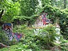 | March 15, 2006 (#06000123) | 1400 McConnell Dr., Mason Mill Park 33°48′28″N84°18′08″W / 33.807778°N 84.302222°W | Decatur | |
| 17 | DeKalb Avenue-Clifton Road Archeological Site | December 14, 1978 (#78003094) | Address Restricted | Atlanta | ||
| 18 | Donaldson-Bannister House and Cemetery |  | August 9, 2009 (#09000585) | 4831 Chamblee-Dunwoody Rd. 33°55′58″N84°19′02″W / 33.932722°N 84.317253°W | Dunwoody | |
| 19 | Druid Hills Historic District |  | October 25, 1979 (#79000715) | U.S. 29 33°46′44″N84°19′47″W / 33.778889°N 84.329722°W | Atlanta | |
| 20 | Druid Hills Parks and Parkways | April 11, 1975 (#75002070) | Both sides of Ponce de Leon Ave. between Briarcliff Rd. and the Seaboard Coast Line RR tracks 33°46′24″N84°19′58″W / 33.773333°N 84.332778°W | Atlanta | Within or near Druid Hills, Georgia, a CDP. Druid Hills Parks and Parkways is inside the Druid Hills Historic District. | |
| 21 | East Atlanta Historic District | June 25, 2021 (#100006668) | Roughly bounded by I 20; Moreland Ave. Edgemore Dr., Elmhurst Cir., Wainwright Dr., and Fayetteville Rd. 33°43′52″N84°20′22″W / 33.7311°N 84.3394°W | Atlanta | ||
| 22 | Emory Grove Historic District |  | March 31, 2000 (#00000300) | Centered on N. Decatur Rd. bet. the CSX RR and the University Park-Emory Highlands-Emory Estates HD 33°47′38″N84°18′54″W / 33.793889°N 84.315°W | Decatur | |
| 23 | Emory University District |  | November 20, 1975 (#75002071) | N. Decatur Rd. 33°47′28″N84°19′12″W / 33.791111°N 84.32°W | Atlanta | |
| 24 | Neville and Helen Farmer Lustron House |  | March 18, 1996 (#96000211) | 513 Drexel Ave. 33°46′17″N84°18′31″W / 33.771389°N 84.308611°W | Decatur | |
| 25 | Dr. Luther C. and Lucy Hurt Fischer House | 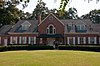 | June 8, 2011 (#11000331) | 4146 Chamblee Dunwoody Rd. 33°54′48″N84°18′46″W / 33.913333°N 84.312778°W | Atlanta | |
| 26 | Mary Gay House |  | May 6, 1975 (#75002072) | 716 W. Trinity Pl. 33°46′22″N84°18′16″W / 33.772662°N 84.304532°W | Decatur | |
| 27 | William T. Gentry House | 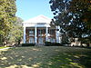 | May 2, 1985 (#85000935) | 132 E. Lake Dr., SE 33°44′53″N84°18′04″W / 33.748056°N 84.301111°W | Atlanta | |
| 28 | Cora Beck Hampton Schoolhouse and House |  | April 16, 1992 (#92000366) | 213 Hillyer Pl. 33°46′25″N84°17′24″W / 33.773611°N 84.29°W | Decatur | |
| 29 | Inman Park-Moreland Historic District | 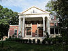 | June 5, 1986 (#86001209) | Roughly bounded by N. Highland, Seminole and Euclid, DeKalb, and Degress and Nashita Aves. Boundary increase (listed October 13, 2003, refnum 03001016): Roughly bounded by Cleburne, Moreland and DeKalb Aves., Battery Place and a city park 33°45′50″N84°21′07″W / 33.763889°N 84.351944°W | Atlanta | A historic district that spans the DeKalb County-Fulton County border |
| 30 | Kirkwood Historic District | 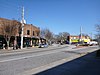 | September 24, 2009 (#09000749) | Roughly bounded by Memorial Dr., Montgomery St., Hosea Williams Dr., Rogers St., CSX RR., & city limits 33°45′02″N84°20′02″W / 33.750672°N 84.334017°W | Atlanta | |
| 31 | Kirkwood School | September 19, 2002 (#02001045) | 138 Kirkwood Rd. 33°45′27″N84°19′20″W / 33.7575°N 84.322222°W | Atlanta | ||
| 32 | Klondike Historic District | September 27, 2007 (#07001001) | Klondike and S. Goddard Rds. 33°39′06″N84°07′30″W / 33.651544°N 84.125069°W | Klondike | ||
| 33 | Agnes Lee Chapter House of the United Daughters of the Confederacy | 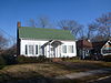 | July 25, 1985 (#85001621) | 120 Avery St. 33°46′15″N84°17′25″W / 33.770833°N 84.290278°W | Decatur | |
| 34 | Lithonia Historic District | September 19, 2016 (#16000639) | Centered on jct. of CSX RR. & Main St. 33°42′44″N84°06′20″W / 33.712132°N 84.105643°W | Lithonia | ||
| 35 | Longview-Huntley Hills Historic District | March 13, 2017 (#100000730) | Montford, Commodore & Admiral Drs., Shallowford Rd. 33°54′32″N84°18′07″W / 33.908921°N 84.302043°W | Chamblee | ||
| 36 | McDonough-Adams-Kings Highway Historic District | December 24, 2013 (#13000965) | Bounded by W. College Ave., Kings Hwy., Oakview Rd. & McDonough St. 33°45′56″N84°17′53″W / 33.765627°N 84.29816°W | Decatur | ||
| 37 | Northcrest Historic District | April 17, 2017 (#100000883) | Roughly bounded by Chamblee-Tucker, Northcrest & Pleasantdale Rds. 33°53′21″N84°14′39″W / 33.889137°N 84.244274°W | Doraville vicinity | ||
| 38 | Northwoods Historic District | June 2, 2014 (#14000322) | Roughly bounded by Buford Hwy., Chamblee-Tucker & Shallowford Rds., I-85 & I-285 33°53′23″N84°16′34″W / 33.889811°N 84.276045°W | Doraville | Large, intact example of mid-century and contemporary architecture. Developed to provide affordable homes for middle-class workers in nearby industries. Includes a mix of uses as a planned use development. | |
| 39 | Oglethorpe University Historic District |  | August 6, 1994 (#94000779) | 4484 Peachtree Rd. NE. 33°52′26″N84°19′55″W / 33.873889°N 84.331944°W | Brookhaven | |
| 40 | Historic DeKalb County Courthouse |  | August 26, 1971 (#71001016) | Court Sq. 33°46′30″N84°17′48″W / 33.775°N 84.296667°W | Decatur | Courthouse built in 1918 following a fire. Neoclassical in style and granite exterior. Used as courthouse until 1967 |
| 41 | William and Minnie Pearce House |  | January 27, 2012 (#11001055) | 125 Madison Ave. 33°45′37″N84°18′43″W / 33.760153°N 84.312033°W | Decatur | |
| 42 | Ponce de Leon Court Historic District |  | November 2, 2011 (#11000774) | Ponce de Leon Ct. 33°46′37″N84°17′26″W / 33.776944°N 84.290556°W | Decatur | |
| 42 | Ponce de Leon Terrace-Ponce de Leon Heights-Clairmont Estates Historic District |  | July 2, 2014 (#14000358) | Roughly bounded by Ponce de Leon Pl., Scott Blvd., Nelson Ferry Rd., Ponce de Leon & Clairmont Aves. 33°46′37″N84°17′26″W / 33.776944°N 84.290556°W | Decatur | Other Names: West Clairemont (NRHP) |
| 43 | Pythagoras Lodge No. 41, Free and Accepted Masons |  | August 19, 1982 (#82004664) | 136 E. Ponce de Leon Ave. 33°46′32″N84°17′47″W / 33.775556°N 84.296389°W | Decatur | |
| 44 | Scottish Rite Hospital for Crippled Children |  | June 17, 1982 (#82004665) | 321 W. Hill St. 33°45′36″N84°18′09″W / 33.76°N 84.3025°W | Decatur | Boundary decrease on September 4, 2004 (04000929) |
| 45 | The Seminary |  | November 15, 1978 (#78003097) | 6886 Main St. 33°42′36″N84°06′34″W / 33.7101°N 84.1094°W | Lithonia | |
| 46 | Smith-Benning House | 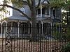 | June 28, 1982 (#82004663) | 520 Oakdale Rd., NE 33°46′05″N84°20′32″W / 33.768056°N 84.342222°W | Atlanta | |
| 47 | Soapstone Ridge |  | May 7, 1973 (#73002138) | Address Restricted | Atlanta | |
| 48 | South Candler Street-Agnes Scott College Historic District |  | July 29, 1994 (#94000787) | Roughly bounded by E. College, S. McDonough, S. Candler, E. Hill and E. Davis Sts. 33°45′54″N84°17′37″W / 33.765°N 84.293611°W | Decatur | |
| 49 | Steele-Cobb House |  | June 17, 1982 (#82004666) | 2632 Fox Hills Dr. 33°48′15″N84°16′52″W / 33.804167°N 84.281111°W | Decatur | |
| 50 | Stone Mountain Historic District |  | December 7, 2000 (#00001476) | Roughly bounded by Stone Mountain Cemetery, Stone Mountain Memorial Park, Lucile St. CSX RR, VFW Dr., and Stone Mtn City 33°48′27″N84°10′15″W / 33.8075°N 84.170833°W | Stone Mountain | |
| 51 | Swanton House |  | August 30, 1978 (#78000977) | 720 Swanton Way 33°46′19″N84°18′19″W / 33.771944°N 84.305278°W | Decatur | |
| 52 | United States Post Office-Decatur, Georgia |  | July 5, 2000 (#00000753) | 141 Trinity Place 33°46′22″N84°17′43″W / 33.772771°N 84.295407°W | Decatur | |
| 53 | University Park-Emory Highlands-Emory Estates Historic District | August 31, 1998 (#97001638) | Roughly bounded by N. Decatur Rd., Durand Dr., Peavine Cr., and the Druid Hills Historic District 33°47′24″N84°18′57″W / 33.79°N 84.315833°W | Decatur | ||
| 54 | Villa MiraFlores | 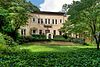 | June 23, 2016 (#15000964) | 1214 Villa Dr. 33°47′26″N84°20′24″W / 33.790498°N 84.340093°W | Atlanta | |
| 55 | Winnona Park Historic District |  | May 30, 2002 (#02000565) | Roughly bounded by E. College Ave., Avery St., S. Columbia Dr., and Mimosa Dr. 33°46′02″N84°17′17″W / 33.767222°N 84.288056°W | Decatur | |
| 56 | Zuber-Jarrell House |  | September 30, 1997 (#97001194) | 810 Flat Shoals Ave., SE 33°44′03″N84°20′17″W / 33.734167°N 84.338056°W | Atlanta |
| [2] | Name on the Register | Image | Date listed | Date removed | Location | City or town | Description |
|---|---|---|---|---|---|---|---|
| 1 | Russell and Nelle Pines Lustron House | March 18, 1996 (#96000207) | January 14, 2013 | 2081 Sylvania Dr. 33°48′50″N84°18′16″W / 33.813889°N 84.304444°W | Decatur | Demolished in 2005 |
This is a list of the more than 2,000 properties and historic districts in the U.S. state of Georgia that are listed on the National Register of Historic Places. Listings are distributed across all of Georgia's 159 counties. Listings for the city of Atlanta are primarily in Fulton County's list but spill over into DeKalb County's list.

This is a list of the National Register of Historic Places listings in DeKalb County, Alabama.

This is a list of the National Register of Historic Places listings in DeKalb County, Illinois.
This is a list of properties and districts in Fulton County, Georgia that are listed on the National Register of Historic Places (NRHP). It covers most of the NRHP properties in Atlanta; other Atlanta listings are covered in National Register of Historic Places listings in DeKalb County, Georgia.

This is a list of the National Register of Historic Places listings in Allen County, Indiana.
This is a list of the National Register of Historic Places listings in DeKalb County, Indiana.

This is a list of the National Register of Historic Places listings in Noble County, Indiana.

This is a list of the National Register of Historic Places listings in Steuben County, Indiana.

This is a list of the National Register of Historic Places listings in Defiance County, Ohio.

This is a list of the National Register of Historic Places listings in Williams County, Ohio.
This is a list of properties and districts in Walton County, Georgia that are listed on the National Register of Historic Places (NRHP).
This is a list of properties and districts in Thomas County, Georgia that are listed on the National Register of Historic Places (NRHP).

This is a list of properties and districts in Muscogee County, Georgia that are listed on the National Register of Historic Places (NRHP).

This is a list of properties and districts in Gwinnett County, Georgia that are listed on the National Register of Historic Places (NRHP).
This is a list of properties and districts in Clayton County, Georgia that are listed on the National Register of Historic Places (NRHP).

This is a list of properties and districts in Hall County, Georgia that are listed on the National Register of Historic Places (NRHP).
This is a list of properties and districts in Coweta County, Georgia that are listed on the National Register of Historic Places (NRHP).

This is a list of properties and districts in Pike County, Georgia that are listed on the National Register of Historic Places (NRHP).
This is a list of properties and districts in Haralson County, Georgia that are listed on the National Register of Historic Places (NRHP).
This is a list of properties and districts in Jenkins County, Georgia that are listed on the National Register of Historic Places (NRHP).
| Topics | |
|---|---|
| Lists by state |
|
| Lists by insular areas | |
| Lists by associated state | |
| Other areas | |
| Related | |
