National Register of Historic Places listings in Stewart County, Georgia

Last updated

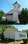
This is a list of properties and districts in Stewart County, Georgia that are listed on the National Register of Historic Places (NRHP).

Historic district section of a city which contains older buildings considered valuable for historical or architectural reasons

A historic district or heritage district is a section of a city which contains older buildings considered valuable for historical or architectural reasons. In some countries or jurisdictions, historic districts receive legal protection from certain types of development considered to be inappropriate.

Stewart County, Georgia County in the United States

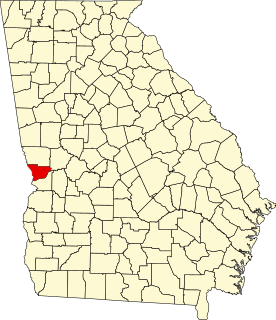
Stewart County is a county located in the west portion of the U.S. state of Georgia. As of the 2010 census, the population was 6,058. The county seat is Lumpkin. The county was created on December 23, 1830.

National Register of Historic Places federal list of historic sites in the United States

The National Register of Historic Places (NRHP) is the United States federal government's official list of districts, sites, buildings, structures and objects deemed worthy of preservation for their historical significance. A property listed in the National Register, or located within a National Register Historic District, may qualify for tax incentives derived from the total value of expenses incurred in preserving the property.

Map all coordinates using: OpenStreetMap  
Download coordinates as: KML  ·  GPX
This National Park Service list is complete through NPS recent listings posted June 28, 2019. [1]

Current listings

[2] Name on the RegisterImageDate listed [3] Location City or townDescription
1 Armstrong House June 29, 1982
(#82002466)
Broad St.
32°03′04″N84°47′34″W / 32.051111°N 84.792778°W / 32.051111; -84.792778 (Armstrong House)
Lumpkin
2 Bedingfield Inn
Bedingfield Inn Bedingfield Inn; Lumpkin, GA.JPG
Bedingfield Inn
May 7, 1973
(#73000643)
Cotton St.
32°03′02″N84°47′44″W / 32.050556°N 84.795556°W / 32.050556; -84.795556 (Bedingfield Inn)
Lumpkin Built c. 1836
3 Bush-Usher House June 29, 1982
(#82002467)
E. Main St.
32°02′58″N84°47′29″W / 32.049444°N 84.791389°W / 32.049444; -84.791389 (Bush-Usher House)
Lumpkin
4 Dr. Miller's Office June 29, 1982
(#82002468)
E. Main St.
32°03′00″N84°47′31″W / 32.05°N 84.791944°W / 32.05; -84.791944 (Dr. Miller's Office)
Lumpkin
5 East Main Street Residential Historic District June 29, 1982
(#82002469)
E. Main St.
32°02′59″N84°47′34″W / 32.049722°N 84.792778°W / 32.049722; -84.792778 (East Main Street Residential Historic District)
Lumpkin
6 Green Grove Church, School, and Cemetery
Green Grove Church, School, and Cemetery Green Grove Church and Schoolhouse (Lumpkin, GA).jpg
Green Grove Church, School, and Cemetery
June 20, 1995
(#95000734)
4062 Old Lumpkin-Eufaula Rd.
32°00′26″N84°51′44″W / 32.007222°N 84.862222°W / 32.007222; -84.862222 (Green Grove Church, School, and Cemetery)
Lumpkin
7 Dr. R. L. Grier House June 29, 1982
(#82002470)
Broad St.
32°03′04″N84°48′10″W / 32.051111°N 84.802778°W / 32.051111; -84.802778 (Dr. R. L. Grier House)
Lumpkin
8 George Y. Harrell House June 29, 1982
(#82002471)
Broad St.
32°03′02″N84°48′09″W / 32.050556°N 84.8025°W / 32.050556; -84.8025 (George Y. Harrell House)
Lumpkin
9 Jared Irwin House June 29, 1982
(#82002472)
E. Main St.
32°02′58″N84°47′31″W / 32.049444°N 84.791944°W / 32.049444; -84.791944 (Jared Irwin House)
Lumpkin
10 Louvale Church Row Historic District
Louvale Church Row Historic District Louvale Church Row Historic District (Louvale, GA).jpg
Louvale Church Row Historic District
April 11, 1986
(#86000747)
US 27
32°10′38″N84°49′31″W / 32.177222°N 84.825278°W / 32.177222; -84.825278 (Louvale Church Row Historic District)
Louvale
11 Lumpkin Commercial Historic District
Lumpkin Commercial Historic District Stewart County Courthouse.jpg
Lumpkin Commercial Historic District
June 29, 1982
(#82002473)
Main, Broad, Cotton, and Mulberry Sts.
32°03′00″N84°47′41″W / 32.05°N 84.794722°W / 32.05; -84.794722 (Lumpkin Commercial Historic District)
Lumpkin
12 Mathis House June 29, 1982
(#82002474)
E. Main St.
32°03′00″N84°47′28″W / 32.05°N 84.791111°W / 32.05; -84.791111 (Mathis House)
Lumpkin
13 Dr. Thomas B. Miller House
Dr. Thomas B. Miller House Dr. Thomas B. Miller House (Richland, GA).JPG
Dr. Thomas B. Miller House
March 2, 1988
(#87001900)
97 Nicholson St.
32°05′17″N84°40′06″W / 32.088056°N 84.668333°W / 32.088056; -84.668333 (Dr. Thomas B. Miller House)
Richland
14 Old Chattahoochee County Courthouse September 18, 1980
(#80001233)
SW of Lumpkin, in Westville, being moved to Columbus
32°02′25″N84°47′13″W / 32.0404°N 84.787°W / 32.0404; -84.787 (Old Chattahoochee County Courthouse)
Lumpkin One of three antebellum courthouses still existing in Georgia.
15 Pigtail Alley Historic District June 29, 1982
(#82002475)
Old Chestnut Rd.
32°02′49″N84°48′01″W / 32.046944°N 84.800278°W / 32.046944; -84.800278 (Pigtail Alley Historic District)
Lumpkin
16 Nathaniel Prothro Plantation
Nathaniel Prothro Plantation Nathaniel Prothro Plantation; Richland, GA.JPG
Nathaniel Prothro Plantation
May 2, 1985
(#85000939)
Old Americus Rd.
32°06′05″N84°39′02″W / 32.101389°N 84.650556°W / 32.101389; -84.650556 (Nathaniel Prothro Plantation)
Richland
17 Richland Historic District
Richland Historic District Richland Depot (City Hall) (c. 1890) (Richland, GA).JPG
Richland Historic District
May 5, 1986
(#86001021)
Roughly bounded by Ponder, Harmony, Broad and Olemen, and Wali Sts.
32°05′27″N84°39′45″W / 32.090833°N 84.6625°W / 32.090833; -84.6625 (Richland Historic District)
Richland
18 Stoddard Rockwell House June 29, 1982
(#82002476)
Rockwell St.
32°03′07″N84°47′44″W / 32.051944°N 84.795556°W / 32.051944; -84.795556 (Stoddard Rockwell House)
Lumpkin
19 Roods Landing Site
Roods Landing Site Rood Creek Landing Recreation Area; Omaha, GA.JPG
Roods Landing Site
August 19, 1975
(#75000609)
S of Omaha at confluence of Rood Creek and the Chattahoochee River
32°01′40″N85°02′37″W / 32.027778°N 85.043611°W / 32.027778; -85.043611 (Roods Landing Site)
Omaha
20 Second Methodist Church June 29, 1982
(#82002477)
Mulberry St.
32°02′49″N84°47′37″W / 32.046944°N 84.793611°W / 32.046944; -84.793611 (Second Methodist Church)
Lumpkin
21 Singer-Moye Archeological Site August 1, 1975
(#75000608)
Address Restricted
Lumpkin
22 Smith-Alston House June 20, 1980
(#80001235)
405 Ponder St.
32°05′38″N84°39′42″W / 32.093889°N 84.661667°W / 32.093889; -84.661667 (Smith-Alston House)
Richland
23 Stewart County Courthouse
Stewart County Courthouse Stewart County Courthouse in Lumpkin, Georgia, USA, July 2008.jpg
Stewart County Courthouse
September 18, 1980
(#80001234)
Courthouse Sq.
32°03′01″N84°47′40″W / 32.050278°N 84.794444°W / 32.050278; -84.794444 (Stewart County Courthouse)
Lumpkin
24 John A. Tucker House June 29, 1982
(#82002478)
Florence St.
32°03′10″N84°47′47″W / 32.052778°N 84.796389°W / 32.052778; -84.796389 (John A. Tucker House)
Lumpkin
25 Uptown Residential Historic District
Uptown Residential Historic District Uptown Residential Historic District Home.jpg
Uptown Residential Historic District
June 29, 1982
(#82002479)
Broad and Main Sts.
32°03′06″N84°47′52″W / 32.051667°N 84.797778°W / 32.051667; -84.797778 (Uptown Residential Historic District)
Lumpkin
26 Usher House
Usher House Travis Usher House (c. 1836); Lumpkin, GA.JPG
Usher House
June 29, 1982
(#82002480)
Florence St.
32°03′08″N84°48′04″W / 32.052222°N 84.801111°W / 32.052222; -84.801111 (Usher House)
Lumpkin Built c. 1836
27 West Hill
West Hill West Hill; Lumpkin, GA.JPG
West Hill
September 18, 1978
(#78001006)
S of Lumpkin on U.S. 27
32°00′20″N84°47′53″W / 32.005556°N 84.798056°W / 32.005556; -84.798056 (West Hill)
Lumpkin

Related Research Articles

National Register of Historic Places listings in Iowa Wikimedia list article

This is a list of properties and historic districts in Iowa that are listed on the National Register of Historic Places. There are listings in all of Iowa's 99 counties, adding up to over 2,300 total.

The following is a list of Registered Historic Places in Branch County, Michigan.

The following is a list of Registered Historic Places in Eaton County, Michigan.

The following is a list of Registered Historic Places in Huron County, Michigan.

The following is a list of Registered Historic Places in Livingston County, Michigan.

The following is a list of Registered Historic Places in Tuscola County, Michigan.

This is a list of places on the National Register of Historic Places in Concord, Massachusetts.

National Register of Historic Places listings in Medford, Massachusetts Wikimedia list article

This is a list of places and properties listed on the National Register of Historic Places in Medford, Massachusetts.

This is a list of the National Register of Historic Places listings in Brookline, Massachusetts.

List of Registered Historic Places in Marlborough, Massachusetts

National Register of Historic Places listings in Fulton County, Georgia Wikimedia list article

This is a list of properties and districts in Fulton County, Georgia that are listed on the National Register of Historic Places (NRHP). It covers most of the NRHP properties in Atlanta; other Atlanta listings are covered in National Register of Historic Places listings in DeKalb County, Georgia.

National Register of Historic Places listings in Muscogee County, Georgia Wikimedia list article

This is a list of properties and districts in Muscogee County, Georgia that are listed on the National Register of Historic Places (NRHP).

This is a list of properties and districts in Clarke County, Georgia that are listed on the National Register of Historic Places (NRHP).

National Register of Historic Places listings in Gwinnett County, Georgia Wikimedia list article

This is a list of properties and districts in Gwinnett County, Georgia that are listed on the National Register of Historic Places (NRHP).

National Register of Historic Places listings in Pike County, Georgia Wikimedia list article

This is a list of properties and districts in Pike County, Georgia that are listed on the National Register of Historic Places (NRHP).

This is a list of properties and districts in Haralson County, Georgia that are listed on the National Register of Historic Places (NRHP).

Framingham, Massachusetts, has 18 locations listed on the National Register of Historic Places.

Weston, Massachusetts has 15 locations listed on the National Register of Historic Places.

National Register of Historic Places listings in Barnstable, Massachusetts Wikimedia list article

Barnstable, Massachusetts, has more than 75 entries on the National Register of Historic Places. For listings elsewhere in Barnstable County, see National Register of Historic Places listings in Barnstable County, Massachusetts.

National Register of Historic Places listings in northern Worcester County, Massachusetts Wikimedia list article

This is a list of the National Register of Historic Places (NRHP) designated in northern Worcester County, Massachusetts. It includes listings from all Worcester County communities through which Massachusetts Route 2 passes, and those that lie to their north. This includes the communities of Ashburnham, Ashby, Athol, Fitchburg, Gardner, Harvard, Lancaster, Leominster, Lunenburg, Phillipston, Royalston, Templeton, Westminster, and Winchendon. National Register listings for other communities in the county are listed elsewhere.

References

  1. "National Register of Historic Places: Weekly List Actions". National Park Service, United States Department of the Interior. Retrieved on June 28, 2019.
  2. Numbers represent an ordering by significant words. Various colorings, defined here, differentiate National Historic Landmarks and historic districts from other NRHP buildings, structures, sites or objects.
  3. The eight-digit number below each date is the number assigned to each location in the National Register Information System database, which can be viewed by clicking the number.