National Register of Historic Places listings in Bibb County, Georgia

Last updated

This is a list of properties and districts in Bibb County, Georgia that are listed on the National Register of Historic Places (NRHP).

Contents

Map all coordinates using: OpenStreetMap


    This National Park Service list is complete through NPS recent listings posted December 15, 2023. [1]

Current listings

[2] Name on the RegisterImageDate listed [3] Location City or townDescription
1 Capt. R. J. Anderson House
Capt. R. J. Anderson House Capt. R. J. Anderson House.JPG
Capt. R. J. Anderson House
May 27, 1971
(#71000246)
1730 West End Ave.
32°49′54″N83°39′08″W / 32.831667°N 83.652222°W / 32.831667; -83.652222 (Capt. R. J. Anderson House)
Macon
2 Judge Clifford Anderson House
Judge Clifford Anderson House Judge Clifford Anderson House.jpg
Judge Clifford Anderson House
July 14, 1971
(#71000247)
642 Orange St.
32°50′10″N83°38′18″W / 32.836111°N 83.638333°W / 32.836111; -83.638333 (Judge Clifford Anderson House)
Macon
3 Ambrose Baber House
Ambrose Baber House Ambrose Baber House.JPG
Ambrose Baber House
August 14, 1973
(#73000608)
577-587 Walnut St.
32°50′20″N83°37′35″W / 32.838889°N 83.626389°W / 32.838889; -83.626389 (Ambrose Baber House)
Macon
4 Charles L. Bowden Golf Course
Charles L. Bowden Golf Course 1st. Hole Charles L.. Bowden Golf Course.jpg
Charles L. Bowden Golf Course
February 23, 2015
(#15000024)
3111 Millerfield Rd.
32°51′48″N83°34′09″W / 32.8632°N 83.5692°W / 32.8632; -83.5692 (Charles L. Bowden Golf Course)
Macon
5 Thomas C. Burke House
Thomas C. Burke House Burke House.jpg
Thomas C. Burke House
June 21, 1971
(#71000248)
1085 Georgia Ave.
32°50′27″N83°38′12″W / 32.840833°N 83.636667°W / 32.840833; -83.636667 (Thomas C. Burke House)
Macon
6 Cannonball House
Cannonball House Cannonball House.JPG
Cannonball House
May 27, 1971
(#71000249)
856 Mulberry St.
32°50′24″N83°37′56″W / 32.84002°N 83.63224°W / 32.84002; -83.63224 (Cannonball House)
Macon
7 Central City Park Bandstand
Central City Park Bandstand Central City Park Bandstand.JPG
Central City Park Bandstand
March 16, 1972
(#72000361)
Central City Park
32°49′59″N83°36′55″W / 32.833056°N 83.615278°W / 32.833056; -83.615278 (Central City Park Bandstand)
Macon
8 Cherokee Brick and Tile Company
Cherokee Brick and Tile Company View from Waterville Road.JPG
Cherokee Brick and Tile Company
April 11, 2002
(#02000338)
3250 Waterville Rd.
32°46′01″N83°37′24″W / 32.766944°N 83.623333°W / 32.766944; -83.623333 (Cherokee Brick and Tile Company)
Macon
9 Cherokee Heights District July 8, 1982
(#82002385)
Pio Nono, Napier, Inverness, and Suwanee Aves.
32°50′17″N83°39′58″W / 32.838056°N 83.666111°W / 32.838056; -83.666111 (Cherokee Heights District)
Macon
10 Christ Episcopal Church
Christ Episcopal Church Christ Episcopal Church (best).JPG
Christ Episcopal Church
July 14, 1971
(#71000250)
538-566 Walnut St.
32°50′18″N83°37′35″W / 32.838333°N 83.626389°W / 32.838333; -83.626389 (Christ Episcopal Church)
Macon
11 Collins-Odom-Strickland House
Collins-Odom-Strickland House Collins-Odom-Strickland House 2.JPG
Collins-Odom-Strickland House
January 22, 1979
(#79000698)
1495 2nd St.
32°49′25″N83°38′23″W / 32.823611°N 83.639722°W / 32.823611; -83.639722 (Collins-Odom-Strickland House)
Macon
12 Cowles House
Cowles House Cowles House.JPG
Cowles House
June 21, 1971
(#71000251)
988 Bond St.
32°50′32″N83°38′04″W / 32.842222°N 83.634444°W / 32.842222; -83.634444 (Cowles House)
Macon
13 Jerry Cowles Cottage
Jerry Cowles Cottage Jerry Cowles Cottage.JPG
Jerry Cowles Cottage
June 21, 1971
(#71000252)
4569 Rivoli Dr.
32°52′26″N83°42′17″W / 32.873889°N 83.704722°W / 32.873889; -83.704722 (Jerry Cowles Cottage)
Macon
14 Dasher-Stevens House
Dasher-Stevens House Dasher-Stevens House.JPG
Dasher-Stevens House
October 18, 1972
(#72000362)
904 Orange Ter.
32°49′59″N83°38′20″W / 32.833056°N 83.638889°W / 32.833056; -83.638889 (Dasher-Stevens House)
Macon
15 Davis-Guttenberger-Rankin House
Davis-Guttenberger-Rankin House Davis-Guttenberger-Rankin House.JPG
Davis-Guttenberger-Rankin House
November 30, 1973
(#73000609)
134 Buford Pl.
32°50′47″N83°39′35″W / 32.846389°N 83.659722°W / 32.846389; -83.659722 (Davis-Guttenberger-Rankin House)
Macon
16 Domingos House
Domingos House Domingos House.JPG
Domingos House
June 21, 1971
(#71000253)
1261 Jefferson Ter.
32°50′28″N83°38′22″W / 32.841111°N 83.639444°W / 32.841111; -83.639444 (Domingos House)
Macon
17 East Macon Historic District April 1, 1993
(#93000281)
Roughly bounded by Emery Hwy., Coliseum Dr., and Clinton, Fletcher and Fairview Sts.
32°50′42″N83°36′43″W / 32.845°N 83.611944°W / 32.845; -83.611944 (East Macon Historic District)
Macon
18 Emerson-Holmes Building
Emerson-Holmes Building Emerson-Holmes Building 566 Mulberry St Macon Georgia in 2012.jpg
Emerson-Holmes Building
June 21, 1971
(#71000254)
566 Mulberry St.
32°50′13″N83°37′39″W / 32.836944°N 83.6275°W / 32.836944; -83.6275 (Emerson-Holmes Building)
Macon
19 Robert Findlay House January 20, 1972
(#72000363)
785 2nd St.
32°49′54″N83°38′01″W / 32.831667°N 83.633611°W / 32.831667; -83.633611 (Robert Findlay House)
Macon Demolished [4]
20 First Presbyterian Church
First Presbyterian Church First Presbyterian Church.jpg
First Presbyterian Church
September 14, 1972
(#72000364)
690 Mulberry St.
32°50′17″N83°37′47″W / 32.838056°N 83.629722°W / 32.838056; -83.629722 (First Presbyterian Church)
Macon
21 Fort Hawkins Archeological Site
Fort Hawkins Archeological Site Fort Hawkins Macon, Georgia.jpg
Fort Hawkins Archeological Site
November 23, 1977
(#77000410)
Address Restricted 32°50′56″N83°36′42″W / 32.8489°N 83.6116°W / 32.8489; -83.6116
Macon
22 Fort Hill Historic District April 16, 1993
(#93000313)
Roughly bounded by Emery Hwy., Second St. Ext., Mitchell and Morrow Sts. and Schaeffer Pl.
32°51′06″N83°36′51″W / 32.851667°N 83.614167°W / 32.851667; -83.614167 (Fort Hill Historic District)
Macon
23 Georgia Industrial Home December 9, 2019
(#100004743)
4690 North Mumford Rd.
32°50′50″N83°42′49″W / 32.8472°N 83.7136°W / 32.8472; -83.7136 (Georgia Industrial Home)
Macon
24 Goodall House May 27, 1971
(#71000255)
618 Orange St.
32°50′11″N83°38′17″W / 32.836389°N 83.638056°W / 32.836389; -83.638056 (Goodall House)
Macon Demolished in 1975 to build a medical office building. Uproar over this spurred the creation of a foundation to help prevent further demolitions. [5]
25 Grand Opera House
Grand Opera House GrandOpera.jpg
Grand Opera House
June 22, 1970
(#70000196)
651 Mulberry St.
32°50′20″N83°37′42″W / 32.83884°N 83.62821°W / 32.83884; -83.62821 (Grand Opera House)
Macon
26 Green-Poe House
Green-Poe House Green-Poe House.JPG
Green-Poe House
July 14, 1971
(#71000256)
841-845 Poplar St.
32°50′15″N83°38′01″W / 32.8375°N 83.633611°W / 32.8375; -83.633611 (Green-Poe House)
Macon
27 Hatcher-Groover-Schwartz House
Hatcher-Groover-Schwartz House Hatcher-Groover-Schwrtz House.JPG
Hatcher-Groover-Schwartz House
June 21, 1971
(#71000257)
1144-1146 Georgia Ave.
32°50′27″N83°38′15″W / 32.84070°N 83.63748°W / 32.84070; -83.63748 (Hatcher-Groover-Schwartz House)
Macon
28 Walter R. Holt House
Walter R. Holt House Walter R. Holt House.JPG
Walter R. Holt House
February 24, 2005
(#05000076)
3776 Vineville Ave.
32°51′13″N83°41′15″W / 32.853611°N 83.6875°W / 32.853611; -83.6875 (Walter R. Holt House)
Macon
29 Holt–Peeler–Snow House
Holt-Peeler-Snow House Thaddeus Goode Holt Peeler House Macon Georgia by Frances Benjamin Johnston.jpg
Holt–Peeler–Snow House
June 21, 1971
(#71000258)
1129 Georgia Ave.
32°50′28″N83°38′14″W / 32.84120°N 83.63710°W / 32.84120; -83.63710 (Holt–Peeler–Snow House)
Macon
30 Ingleside Historic District
Ingleside Historic District 3192 Vista Circle.jpg
Ingleside Historic District
May 10, 2016
(#16000231)
Roughly bounded by Vineville Ave, Candler Dr, Bonita Pl, High Point Rd, and Forest Hill Rd.
32°51′26″N83°40′46″W / 32.857132°N 83.679464°W / 32.857132; -83.679464 (Ingleside Historic District)
Macon
31 Johnston-Hay House
Johnston-Hay House Johnston-Felton-Hay House, Macon, GA, US (08).jpg
Johnston-Hay House
May 27, 1971
(#71000259)
934 Georgia Ave.
32°50′25″N83°38′01″W / 32.84034°N 83.63361°W / 32.84034; -83.63361 (Johnston-Hay House)
Macon National Historic Landmark
32 Sidney Lanier Cottage
Sidney Lanier Cottage Lanier Cottage.jpg
Sidney Lanier Cottage
January 31, 1972
(#72000365)
935 High St.
32°50′15″N83°38′11″W / 32.83753°N 83.63629°W / 32.83753; -83.63629 (Sidney Lanier Cottage)
Macon (see Sidney Lanier )
33 Lassiter House
Lassiter House Lassiter House, Macon, GA, US (06).jpg
Lassiter House
April 11, 1972
(#72000366)
315 College St.
32°50′32″N83°38′17″W / 32.842222°N 83.638056°W / 32.842222; -83.638056 (Lassiter House)
Macon Built in 1855, also known as the Beall House, now houses the Robert McDuffee Center for Strings, website
34 Ellamae Ellis League House
Ellamae Ellis League House Ellamae Ellis League House, Macon, GA, US.jpg
Ellamae Ellis League House
February 15, 2005
(#05000053)
1790 Waverland Dr.
32°52′14″N83°37′56″W / 32.870556°N 83.632222°W / 32.870556; -83.632222 (Ellamae Ellis League House)
Macon Also in the Shirley Hills Historic District
35 Joseph and Mary Jane League House
Joseph and Mary Jane League House 1849 Waverland Drive.JPG
Joseph and Mary Jane League House
January 9, 2009
(#08001280)
1849 Waverland Dr.
32°52′24″N83°37′54″W / 32.8733°N 83.6318°W / 32.8733; -83.6318 (Joseph and Mary Jane League House)
Macon Also in the Shirley Hills Historic District
36 W. G. Lee Alumni House
W. G. Lee Alumni House W. G. Lee Alumni House (with sign).JPG
W. G. Lee Alumni House
July 14, 1971
(#71000260)
1270 Ash (Coleman) St.
32°49′52″N83°38′49″W / 32.831111°N 83.646944°W / 32.831111; -83.646944 (W. G. Lee Alumni House)
Macon
37 William and Jane Levitt House
William and Jane Levitt House William & Jane Levitt House.jpg
William and Jane Levitt House
January 26, 2016
(#15000996)
3720 Overlook Dr.
32°51′54″N83°41′01″W / 32.865072°N 83.683710°W / 32.865072; -83.683710 (William and Jane Levitt House)
Macon
38 Lustron House at 3498 McKenzie Drive
Lustron House at 3498 McKenzie Drive Lustrous House at 3498 McKenzie Drive.jpg
Lustron House at 3498 McKenzie Drive
March 18, 1996
(#96000216)
3498 McKenzie Dr.
32°50′53″N83°40′58″W / 32.84816°N 83.68268°W / 32.84816; -83.68268 (Lustron House at 3498 McKenzie Drive)
Macon
39 Macon Historic District
Macon Historic District House on College St., Macon Historic District, Macon, GA, US (15).jpg
Macon Historic District
December 31, 1974
(#74000658)
Roughly bounded by Riverside Dr., Broadway, Elm, and I-75
32°50′11″N83°38′11″W / 32.836389°N 83.636389°W / 32.836389; -83.636389 (Macon Historic District)
Macon This HD contains some of the other NRHP buildings
40 Macon Railroad Industrial District
Macon Railroad Industrial District Terminal Station.JPG
Macon Railroad Industrial District
June 12, 1987
(#87000977)
Roughly bounded by Fifth, Sixth, and Seventh Sts., Central of Georgia, Southern, and Seaboard RR tracks
32°49′31″N83°37′33″W / 32.8253°N 83.6258°W / 32.8253; -83.6258 (Macon Railroad Industrial District)
Macon
41 Macon Railway and Light Company Substation
Macon Railway and Light Company Substation Macon Railway and Light Company Substation.JPG
Macon Railway and Light Company Substation
November 9, 2006
(#06000986)
1015 Riverside Dr.
32°50′41″N83°37′53″W / 32.8447°N 83.6314°W / 32.8447; -83.6314 (Macon Railway and Light Company Substation)
Macon
42 DeWitt McCrary House
DeWitt McCrary House DeWitt McCrary House.jpg
DeWitt McCrary House
March 22, 1974
(#74000659)
320 Hydrolia St.
32°50′37″N83°37′00″W / 32.8436°N 83.6167°W / 32.8436; -83.6167 (DeWitt McCrary House)
Macon
43 Mechanics Engine House No. 4
Mechanics Engine House No. 4 Mechanics Engine House No. 4.JPG
Mechanics Engine House No. 4
September 13, 1990
(#90001434)
950 Third St.
32°49′43″N83°37′58″W / 32.8286°N 83.6328°W / 32.8286; -83.6328 (Mechanics Engine House No. 4)
Macon
44 Mercer University Administration Building
Mercer University Administration Building Mercer University Administration Building.jpg
Mercer University Administration Building
August 26, 1971
(#71000261)
Coleman Ave.
32°49′54″N83°38′54″W / 32.8317°N 83.6483°W / 32.8317; -83.6483 (Mercer University Administration Building)
Macon
45 A.L. Miller High School and A.L. Miller Junior High School
A.L. Miller High School and A.L. Miller Junior High School Miller High 5.JPG
A.L. Miller High School and A.L. Miller Junior High School
November 19, 2014
(#14000928)
2241 Montpelier Ave.
32°50′01″N83°39′30″W / 32.83356°N 83.6584°W / 32.83356; -83.6584 (A.L. Miller High School and A.L. Miller Junior High School)
Macon
46 Militia Headquarters Building
Militia Headquarters Building Emerson & Holmes Building, 556 Mulberry Street, Macon (Bibb County, Georgia).jpg
Militia Headquarters Building
April 11, 1972
(#72000367)
552-564 Mulberry St.
32°50′14″N83°37′39″W / 32.8372°N 83.6275°W / 32.8372; -83.6275 (Militia Headquarters Building)
Macon Building at left edge of photo. Is demolished, site is now an alley/parking area.
47 Monroe Street Apartments
Monroe Street Apartments Monroe Street Apartments.jpg
Monroe Street Apartments
March 16, 1972
(#72000368)
641-661 Monroe St.
32°50′19″N83°38′38″W / 32.8385°N 83.644°W / 32.8385; -83.644 (Monroe Street Apartments)
Macon
48 Municipal Auditorium
Municipal Auditorium Macon Auditorium.JPG
Municipal Auditorium
June 21, 1971
(#71000262)
415-435 1st St.
32°50′14″N83°37′53″W / 32.8372°N 83.6314°W / 32.8372; -83.6314 (Municipal Auditorium)
Macon
49 Munroe-Dunlap-Snow House
Munroe-Dunlap-Snow House Munroe-Dunlap-Snow House.jpg
Munroe-Dunlap-Snow House
July 14, 1971
(#71000263)
920 High St.
32°50′13″N83°38′10″W / 32.837°N 83.636°W / 32.837; -83.636 (Munroe-Dunlap-Snow House)
Macon
50 Munroe-Goolsby House
Munroe-Goolsby House Munroe-Goolsby House.JPG
Munroe-Goolsby House
January 20, 1972
(#72000369)
159 Rogers Ave.
32°50′50″N83°39′18″W / 32.8472°N 83.655°W / 32.8472; -83.655 (Munroe-Goolsby House)
Macon
51 Napier Heights Historic District August 6, 2020
(#100005424)
Roughly bounded by Brentwood and Montpelier Aves., Winship St., I 75, Dannenberg Ave., Lasseter Pl., and Whitehall St.
32°50′10″N83°39′33″W / 32.8360°N 83.6592°W / 32.8360; -83.6592 (Napier Heights Historic District)
Macon
52 Leroy Napier House May 27, 1971
(#71000264)
2215 Napier Ave.
32°50′13″N83°39′18″W / 32.837°N 83.6551°W / 32.837; -83.6551 (Leroy Napier House)
Macon Moved to Clayton County in 2007
53 North Highlands Historic District
North Highlands Historic District North Highlands Historic District, Macon, GA, US (29).jpg
North Highlands Historic District
November 22, 1993
(#93000297)
Roughly bounded by Nottingham Dr., Boulevard and Clinton Rd.
32°51′19″N83°37′25″W / 32.8553°N 83.6236°W / 32.8553; -83.6236 (North Highlands Historic District)
Macon
54 Ocmulgee National Monument
Ocmulgee National Monument Macon Ocmulgee Earth Lodge.jpg
Ocmulgee National Monument
October 15, 1966
(#66000099)
1207 Emory Hwy., E of Macon
32°49′46″N83°36′07″W / 32.8294°N 83.6019°W / 32.8294; -83.6019 (Ocmulgee National Monument)
Macon administered by the National Park Service
55 Old Macon Library
Old Macon Library Old Macon Library.JPG
Old Macon Library
November 26, 1973
(#73000610)
652-662 Mulberry St.
32°50′16″N83°37′44″W / 32.8378°N 83.6289°W / 32.8378; -83.6289 (Old Macon Library)
Macon
56 Old U.S. Post Office and Federal Building
Old U.S. Post Office and Federal Building Old U.S. Post Office and Federal Building.JPG
Old U.S. Post Office and Federal Building
January 20, 1972
(#72000370)
475 Mulberry St.
32°50′13″N83°37′32″W / 32.8369°N 83.6256°W / 32.8369; -83.6256 (Old U.S. Post Office and Federal Building)
Macon
57 Pleasant Hill Historic District
Pleasant Hill Historic District Business @ 2189 3rd Avenue.jpg
Pleasant Hill Historic District
May 22, 1986
(#86001130)
Roughly bounded by Sheridan Ave. and Schofield St., Madison, Jefferson and Ferguson, and Galliard Sts.
32°50′48″N83°38′45″W / 32.8467°N 83.6458°W / 32.8467; -83.6458 (Pleasant Hill Historic District)
Macon
58 James and Olive Porter House
James and Olive Porter House James Porter house, Macon GA.jpg
James and Olive Porter House
January 31, 2019
(#100003381)
231 Tucker Rd.
32°52′21″N83°42′49″W / 32.8724°N 83.7135°W / 32.8724; -83.7135 (James and Olive Porter House)
Macon Moved from Allen St. to Tucker Road on the campus of Wesleyan College
59 Railroad Overpass at Ocmulgee
Railroad Overpass at Ocmulgee Railroad Overpass at Ocmulgee, Bibb County, GA, US.jpg
Railroad Overpass at Ocmulgee
December 18, 1979
(#79000699)
Off GA 49
32°50′29″N83°36′00″W / 32.8414°N 83.600°W / 32.8414; -83.600 (Railroad Overpass at Ocmulgee)
Macon In the Ocmulgee National Monument
60 Raines-Carmichael House
Raines-Carmichael House Cadwalader Raines House ( Bibb County, Georgia).jpg
Raines-Carmichael House
June 21, 1971
(#71000265)
1183 Georgia Ave.
32°50′29″N83°38′15″W / 32.8413°N 83.6376°W / 32.8413; -83.6376 (Raines-Carmichael House)
Macon National Historic Landmark
61 Randolph-Whittle House
Randolph-Whittle House Randolph-Whittle House.JPG
Randolph-Whittle House
February 1, 1972
(#72000371)
1231 Jefferson Ter.
32°50′27″N83°38′18″W / 32.840833°N 83.638333°W / 32.840833; -83.638333 (Randolph-Whittle House)
Macon
62 Riverside Cemetery
Riverside Cemetery Riverside Cemetery 1.JPG
Riverside Cemetery
April 28, 1983
(#83000183)
1301 Riverside Dr.
32°51′04″N83°38′18″W / 32.851111°N 83.638333°W / 32.851111; -83.638333 (Riverside Cemetery)
Macon
63 Rock Rogers House
Rock Rogers House Rock Rogers House.jpg
Rock Rogers House
January 20, 1972
(#72000372)
331 College St.
32°50′33″N83°38′17″W / 32.8426°N 83.63803°W / 32.8426; -83.63803 (Rock Rogers House)
Macon
64 Rose Hill Cemetery
Rose Hill Cemetery Rose Hill Cemetery 2.JPG
Rose Hill Cemetery
October 9, 1973
(#73000611)
Riverside Dr.
32°50′52″N83°38′01″W / 32.847778°N 83.633611°W / 32.847778; -83.633611 (Rose Hill Cemetery)
Macon
65 Shirley Hills Historic District
Shirley Hills Historic District 1725 Waverland Circle.JPG
Shirley Hills Historic District
August 17, 1989
(#89001093)
Roughly Senate Pl., Parkview Dr., Curry Dr., Briarcliff Rd., Nottingham Dr., and the Ocmulgee River;
also roughly bounded by Boulevard Ave., Woodland Dr., Waveland Cir., Nottingham, Briarcliff & Upper River Rds.

32°51′33″N83°37′50″W / 32.859167°N 83.630556°W / 32.859167; -83.630556 (Shirley Hills Historic District)
Macon Boundary increase on May 28, 2014 (#14000269) [6]
66 Slate House
Slate House Slate House.JPG
Slate House
January 21, 1974
(#74000660)
931-945 Walnut St.
32°50′32″N83°37′54″W / 32.842222°N 83.631667°W / 32.842222; -83.631667 (Slate House)
Macon
67 Small House
Small House Small House.JPG
Small House
May 27, 1971
(#71000266)
156 Rogers Ave.
32°50′50″N83°39′21″W / 32.847222°N 83.655833°W / 32.847222; -83.655833 (Small House)
Macon
68 Solomon-Curd House May 27, 1971
(#71000267)
770 Mulberry St.
32°50′22″N83°37′51″W / 32.83936°N 83.63079°W / 32.83936; -83.63079 (Solomon-Curd House)
Macon Gutted by fire January 1977; razed in 1979. [7]
69 Solomon-Smith-Martin House
Solomon-Smith-Martin House Solomon-Smith-Martin House.JPG
Solomon-Smith-Martin House
July 14, 1971
(#71000268)
2619 Vineville Ave.
32°50′47″N83°39′47″W / 32.84626°N 83.66317°W / 32.84626; -83.66317 (Solomon-Smith-Martin House)
Macon
70 St. Joseph's Catholic Church
St. Joseph's Catholic Church St Josephs.jpg
St. Joseph's Catholic Church
July 14, 1971
(#71000269)
812 Poplar St.
32°50′12″N83°38′01″W / 32.836667°N 83.633611°W / 32.836667; -83.633611 (St. Joseph's Catholic Church)
Macon
71 Tindall Heights Historic District July 1, 1993
(#93000587)
Roughly bounded by Broadway, Eisenhower Pkwy., Felton and Nussbaum Aves., Central of Georgia RR tracks and Oglethorpe St
32°49′24″N83°38′36″W / 32.823333°N 83.643333°W / 32.823333; -83.643333 (Tindall Heights Historic District)
Macon
72 Villa Albicini
Villa Albicini Villa Albicini.JPG
Villa Albicini
May 16, 1974
(#74000661)
150 Tucker Rd.
32°52′26″N83°42′41″W / 32.87375°N 83.71134°W / 32.87375; -83.71134 (Villa Albicini)
Macon
73 Vineville Historic District
Vineville Historic District Allman Bros Museum in Macon Georgia USA Sept 2021- 01.jpg
Vineville Historic District
November 21, 1980
(#80000974)
GA 247 and U.S. 41
32°50′46″N83°39′33″W / 32.846111°N 83.659167°W / 32.846111; -83.659167 (Vineville Historic District)
Macon
74 Wesleyan College Historic District
Wesleyan College Historic District Wesleyan College Historic District 2.JPG
Wesleyan College Historic District
April 2, 2004
(#04000242)
4760 Forsyth Rd.
32°52′20″N83°43′08″W / 32.872222°N 83.718889°W / 32.872222; -83.718889 (Wesleyan College Historic District)
Macon a historic district at Wesleyan College
75 Luther Williams Field
Luther Williams Field LuWilMac.jpg
Luther Williams Field
June 24, 2004
(#04000627)
225 Willie Smokey Glover Blvd., Central City Park
32°49′44″N83°36′51″W / 32.828889°N 83.614167°W / 32.828889; -83.614167 (Luther Williams Field)
Macon
76 Willingham-Hill-O'Neal Cottage
Willingham-Hill-O'Neal Cottage Willingham-Hill-O'Neal Cottage.JPG
Willingham-Hill-O'Neal Cottage
July 14, 1971
(#71000270)
535 College St.
32°50′19″N83°38′22″W / 32.838611°N 83.639444°W / 32.838611; -83.639444 (Willingham-Hill-O'Neal Cottage)
Macon

See also

Related Research Articles

The National Register of Historic Places (NRHP) is the United States federal government's official list of districts, sites, buildings, structures, and objects deemed worthy of preservation for their historical significance or "great artistic value". A property listed in the National Register or located within a National Register Historic District, may qualify for tax incentives derived from the total value of expenses incurred in preserving the property.

<span class="mw-page-title-main">Johnston–Felton–Hay House</span> Historic house in Georgia, United States

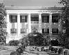
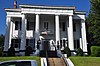
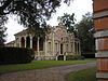
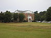
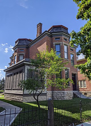
The Johnston–Felton–Hay House, often abbreviated Hay House, is a historic residence at 934 Georgia Avenue in Macon, Georgia. Built between 1855 and 1859 by William Butler Johnston and his wife Anne Tracy Johnston in the Italian Renaissance Revival style, the house has been called the "Palace of the South." The mansion sits atop Coleman Hill on Georgia Avenue in downtown Macon, near the Walter F. George School of Law, part of Mercer University. It was designated a National Historic Landmark in 1973 for its architectural uniqueness.

<span class="mw-page-title-main">National Register of Historic Places listings in Providence, Rhode Island</span>

This is a list of the National Register of Historic Places listings in Providence, Rhode Island.

<span class="mw-page-title-main">National Register of Historic Places listings in Caddo Parish, Louisiana</span>

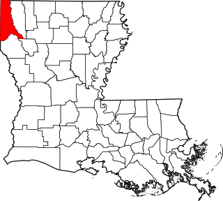
This is a list of the National Register of Historic Places listings in Caddo Parish, Louisiana.

<span class="mw-page-title-main">National Register of Historic Places listings in Avoyelles Parish, Louisiana</span>

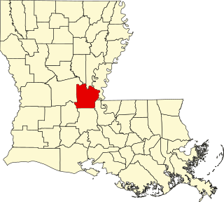
This is a list of the National Register of Historic Places listings in Avoyelles Parish, Louisiana.

<span class="mw-page-title-main">National Register of Historic Places listings in North Philadelphia</span>

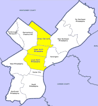
The following properties are listed on the National Register of Historic Places in North Philadelphia.

<span class="mw-page-title-main">National Register of Historic Places listings in Lancaster County, Nebraska</span>

This is a list of the National Register of Historic Places listings in Lancaster County, Nebraska.

<span class="mw-page-title-main">National Register of Historic Places listings in Ada County, Idaho</span>

This is a list of the National Register of Historic Places listings in Ada County, Idaho.

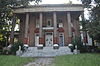
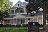
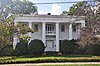
The Goodall House was a historic house located at 618 Orange Street in Macon, Georgia. It was built in 1859 with Italianate exterior and ornate interior. As of 1971, it had been very little altered and it was listed on the National Register of Historic Places. Despite opposition from local preservationists, the house was demolished in 1975 and replaced with an office building.

<span class="mw-page-title-main">National Register of Historic Places listings in Jefferson Parish, Louisiana</span>

This is a list of the National Register of Historic Places listings in Jefferson Parish, Louisiana.

<span class="mw-page-title-main">Davenport Register of Historic Properties</span>

This is a list of the Davenport Register of Historic Properties in Davenport, Iowa, United States.

<span class="mw-page-title-main">National Register of Historic Places listings in Macon County, Georgia</span>

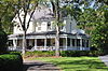
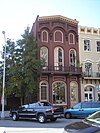
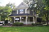
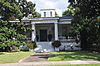
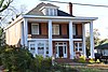
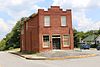
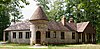
This is a list of properties and districts in Macon County, Georgia that are listed on the National Register of Historic Places (NRHP).

<span class="mw-page-title-main">Macon Historic District (Macon, Georgia)</span> Historic district in Georgia, United States

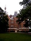
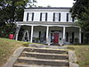
The Macon Historic District is a historic district in Macon, Georgia that was listed on the National Register of Historic Places in 1974 and was expanded in 1995. The original listing covered 587 acres (238 ha) and included 1,050 contributing resources; the increase added 101 acres (41 ha) and 157 contributing resources.

<span class="mw-page-title-main">Ellamae Ellis League</span> American architect (1899–1991)

Ellamae Ellis League, was an American architect, the fourth woman registered architect in Georgia and "one of Georgia and the South's most prominent female architects." She practiced for over 50 years, 41 of them from her own firm. From a family of architects, she was the first woman elected a Fellow of the American Institute of Architects (FAIA) in Georgia and only the eighth woman nationwide. Several buildings she designed are listed on the National Register of Historic Places (NRHP). In 2016 she was posthumously named a Georgia Woman of Achievement.

The Porterdale Historic District in Porterdale, Georgia is a 525 acres (212 ha) historic district which was listed on the National Register of Historic Places in 2001. Its area is roughly the city limits of Porterdale north of Elm St., and it includes Colonial Revival, Late Gothic Revival, and other architecture. In 2001 it included 496 contributing buildings and eight contributing structures. It also included 37 non-contributing buildings and a non-contributing object.

<span class="mw-page-title-main">Columbus Landmarks</span> Historic preservation foundation in Ohio

The Columbus Landmarks Foundation, known as Columbus Landmarks, is a nonprofit historic preservation organization in Columbus, Ohio. The foundation is best-known for its list of endangered sites in the city and its annual design award, given to buildings, landscapes, and other sites created or renovated in Columbus. It was established in 1977 as a project of the Junior League of Columbus, Ohio, following the demolition of the city's historic Union Station. It is headquartered at 57 Jefferson Avenue, a contributing structure in the Jefferson Avenue Historic District in Downtown Columbus.

References

  1. National Park Service, United States Department of the Interior, "National Register of Historic Places: Weekly List Actions", retrieved December 15, 2023.
  2. Numbers represent an alphabetical ordering by significant words. Various colorings, defined here, differentiate National Historic Landmarks and historic districts from other NRHP buildings, structures, sites or objects.
  3. The eight-digit number below each date is the number assigned to each location in the National Register Information System database, which can be viewed by clicking the number.
  4. Fabian, Liz (October 5, 2014). "Family finds lost grave of Macon industrial pioneer". Macon Telegraph . Archived from the original on November 7, 2018. Retrieved November 7, 2018. His ornate home that once stood at 785 Second St. made the National Register of Historic Places but was razed decades ago after serving as home to the YWCA.
  5. Barfield, James E. (2014). "Fifty Years to Celebrate". 50th Anniversary Edition Quarterly Newsletter. Historic Macon Foundation. pp. 6–7. Retrieved November 5, 2018. In 1975 the Goodall-Collins house on Orange Street, an important antebellum Italianate structure, was threatened with demolition. The Historical Society opposed the demolition but did not have the resources or expertise to effect its rescue and the house was demolished. It was replaced by a 1970s modern office building. A group of preservation-minded people were horrified at the loss and officers of the Historical Society supported an effort to form a new organization which would handle "bricks and mortar" preservation.
  6. Shirley Hills Historic District boundary increase nomination form
  7. "Top 5 Notorious Macon Fires - Part 2". Gateway Macon. 2015. Archived from the original on September 7, 2015. Retrieved November 4, 2018. the stately, two-story Greek Revival home located at 770 Mulberry Street had been home to bank presidents and Macon mayor James Nesbit....On a cold January afternoon during business hours in 1977, a store employee noticed that the base of the water heater had caught fire on the first floor....Hart, who founded the Middle Georgia Historical Society, of which he was a honorary president, wanted dearly to preserve the historic home. For two years, Hart was able to dodge City regulations as he tried to secure tenancy. Hart ultimately lost his battle with the city and the building was immediately razed.