National Register of Historic Places listings in Floyd County, Georgia

Last updated

Location of Floyd County in Georgia Map of Georgia highlighting Floyd County.svg
Location of Floyd County in Georgia

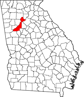
This is a list of properties and districts in Floyd County, Georgia that are listed on the National Register of Historic Places (NRHP).

Map all coordinates using: OpenStreetMap


    This National Park Service list is complete through NPS recent listings posted July 21, 2023. [1]

Current listings

[2] Name on the RegisterImageDate listed [3] Location City or townDescription
1 Dr. Robert Battey House
Dr. Robert Battey House DR. ROBERT BATTEY HOUSE, ROME, FLOYD, GA.jpg
Dr. Robert Battey House
June 17, 1982
(#82002414)
725 E. 2nd Ave.
34°14′35″N85°09′54″W / 34.243056°N 85.165°W / 34.243056; -85.165 (Dr. Robert Battey House)
Rome
2 Berry Schools
Berry Schools Fordgarden.JPG
Berry Schools
July 21, 1978
(#78000981)
N of Rome on U.S. 27
34°18′27″N85°12′49″W / 34.3075°N 85.213611°W / 34.3075; -85.213611 (Berry Schools)
Rome
3 Between the Rivers Historic District
Between the Rivers Historic District Bridge to Heritage Park.jpg
Between the Rivers Historic District
June 9, 1983
(#83000193)
Roughly bounded by the Etowah and Oostanaula Rivers, and 7th Ave.
34°15′06″N85°10′16″W / 34.251667°N 85.171111°W / 34.251667; -85.171111 (Between the Rivers Historic District)
Rome Historic district with more than 200 buildings, plus the Rome Clock Tower and a historic bridge.
4 John M. Carroll House
John M. Carroll House John M. Carroll house, Cave Spring, GA NRHP.png
John M. Carroll House
June 19, 1980
(#80001021)
Park St.
34°06′09″N85°20′23″W / 34.1025°N 85.339722°W / 34.1025; -85.339722 (John M. Carroll House)
Cave Spring
5 Carroll-Harper House
Carroll-Harper House Carroll-Harper House.jpg
Carroll-Harper House
June 19, 1980
(#80001023)
Cedartown St.
34°06′13″N85°20′10″W / 34.103611°N 85.336111°W / 34.103611; -85.336111 (Carroll-Harper House)
Cave Spring
6 Carroll-Richardson Grist Mill June 19, 1980
(#80001025)
Mill St.
34°06′04″N85°20′27″W / 34.101111°N 85.340833°W / 34.101111; -85.340833 (Carroll-Richardson Grist Mill)
Cave Spring
7 Cave Spring Commercial Historic District
Cave Spring Commercial Historic District Downtown Cave Spring.jpg
Cave Spring Commercial Historic District
June 19, 1980
(#80001028)
Alabama, Rome and Cedartown Rds., Broad and Padlock Sts.
34°06′27″N85°20′11″W / 34.1075°N 85.336389°W / 34.1075; -85.336389 (Cave Spring Commercial Historic District)
Cave Spring
8 Cave Spring Female Academy
Cave Spring Female Academy Cave Spring Female Academy.jpg
Cave Spring Female Academy
June 19, 1980
(#80001030)
Rome St.
34°06′43″N85°19′59″W / 34.111944°N 85.333056°W / 34.111944; -85.333056 (Cave Spring Female Academy)
Cave Spring
9 Cave Spring High School June 19, 1980
(#80001032)
Rome St.
34°06′37″N85°20′07″W / 34.110278°N 85.335278°W / 34.110278; -85.335278 (Cave Spring High School)
Cave Spring Demolished
10 Cave Spring Railroad Station
Cave Spring Railroad Station Cave Spring Train Station.jpg
Cave Spring Railroad Station
June 19, 1980
(#80001034)
Alabama St.
34°06′28″N85°20′32″W / 34.107778°N 85.342222°W / 34.107778; -85.342222 (Cave Spring Railroad Station)
Cave Spring
11 Cave Spring Residential Historic District June 19, 1980
(#80001035)
U.S. 411 and GA 100
34°06′29″N85°20′22″W / 34.108056°N 85.339444°W / 34.108056; -85.339444 (Cave Spring Residential Historic District)
Cave Spring
12 Chieftains
Chieftains Chieftains.jpg
Chieftains
April 7, 1971
(#71000273)
80 Chatillon Rd.
34°16′38″N85°10′13″W / 34.27710°N 85.17019°W / 34.27710; -85.17019 (Chieftains)
Rome National Historic Landmark
13 Chubb Methodist Episcopal Church
Chubb Methodist Episcopal Church Chubb United Methodist Church.jpg
Chubb Methodist Episcopal Church
May 4, 1990
(#90000728)
Chubbtown Rd.
34°05′12″N85°16′59″W / 34.086667°N 85.283056°W / 34.086667; -85.283056 (Chubb Methodist Episcopal Church)
Cave Spring
14 Wesley O. Conner House
Wesley O. Conner House Wesley O. Connor House.jpg
Wesley O. Conner House
June 19, 1980
(#80001037)
Cedartown St.
34°06′00″N85°19′51″W / 34.1°N 85.330833°W / 34.1; -85.330833 (Wesley O. Conner House)
Cave Spring
15 Coosa Country Club Golf Course April 14, 2022
(#100007578)
110 Branham Ave SW
34°15′22″N85°11′04″W / 34.2562°N 85.1844°W / 34.2562; -85.1844 (Coosa Country Club Golf Course)
Rome
16 William D. Cowdry Plantation June 19, 1980
(#80001039)
Rome Rd.
34°07′01″N85°20′10″W / 34.116944°N 85.336111°W / 34.116944; -85.336111 (William D. Cowdry Plantation)
Cave Spring
17 Double-Cola Bottling Company
Double-Cola Bottling Company DOUBLE COLA BOTTLING CO, ROME, FLOYD COUNTY, GA.jpg
Double-Cola Bottling Company
August 30, 2006
(#06000738)
419 E. Second Ave.
34°14′52″N85°10′10″W / 34.247778°N 85.169444°W / 34.247778; -85.169444 (Double-Cola Bottling Company)
Rome
18 East Rome Historic District July 25, 1985
(#85001637)
Roughly bounded by Walnut Ave., McCall Blvd., E. 8th and 10th Sts.
34°14′30″N85°09′53″W / 34.241667°N 85.164722°W / 34.241667; -85.164722 (East Rome Historic District)
Rome
19 Fairview School
Fairview School Fairview School.jpg
Fairview School
June 5, 2017
(#100001019)
276 Padlock Mountain Rd., SW.
34°06′06″N85°18′53″W / 34.101790°N 85.314798°W / 34.101790; -85.314798 (Fairview School)
Cave Spring
20 Oliver P. Fannin House June 19, 1980
(#80001041)
Cedartown St.
34°06′16″N85°20′13″W / 34.104444°N 85.336944°W / 34.104444; -85.336944 (Oliver P. Fannin House)
Cave Spring
21 Floyd County Courthouse
Floyd County Courthouse From Rome Clock Tower.jpg
Floyd County Courthouse
September 18, 1980
(#80001067)
5th Ave., and Tribune St.
34°15′22″N85°10′17″W / 34.256111°N 85.171389°W / 34.256111; -85.171389 (Floyd County Courthouse)
Rome
22 Joseph Ford House
Joseph Ford House Joseph Ford House, Cave Spring, GA NRHP.png
Joseph Ford House
June 19, 1980
(#80001043)
Love and Alabama Sts.
34°06′23″N85°20′12″W / 34.106389°N 85.336667°W / 34.106389; -85.336667 (Joseph Ford House)
Cave Spring
23 Georgia School for the Deaf Historic District
Georgia School for the Deaf Historic District Georgia School for the Deaf.jpg
Georgia School for the Deaf Historic District
June 19, 1980
(#80001045)
Padlock St.
34°06′27″N85°20′00″W / 34.1075°N 85.333333°W / 34.1075; -85.333333 (Georgia School for the Deaf Historic District)
Cave Spring
24 Jackson Hill Historic District
Jackson Hill Historic District Jackson Hill Canons MG 1700.jpg
Jackson Hill Historic District
April 25, 1997
(#97000370)
Jackson Hill, between GA 53 and the Oostanaula River
34°15′51″N85°09′52″W / 34.264167°N 85.164444°W / 34.264167; -85.164444 (Jackson Hill Historic District)
Rome
25 Lower Avenue A Historic District September 1, 1983
(#83000194)
Avenue A between N. 5th St. and Turner-McCall Blvd.
34°15′33″N85°10′24″W / 34.259167°N 85.173333°W / 34.259167; -85.173333 (Lower Avenue A Historic District)
Rome
26 Main High School
Main High School Main High School, Rome, GA, US.jpg
Main High School
October 24, 2002
(#02001219)
41 Washington Dr.
34°15′27″N85°09′15″W / 34.2575°N 85.154167°W / 34.2575; -85.154167 (Main High School)
Rome
27 John T. Mann House
John T. Mann House John T. Mann House.jpg
John T. Mann House
June 19, 1980
(#80001047)
Rivers St.
34°06′33″N85°20′12″W / 34.109167°N 85.336667°W / 34.109167; -85.336667 (John T. Mann House)
Cave Spring
28 Mayo's Bar Lock and Dam
Mayo's Bar Lock and Dam Mayo's Bar Lock and Dam, Floyd County, GA, US.jpg
Mayo's Bar Lock and Dam
November 16, 1989
(#89002020)
On the Coosa River, 8 mi. SW of Rome
34°12′02″N85°15′21″W / 34.200556°N 85.255833°W / 34.200556; -85.255833 (Mayo's Bar Lock and Dam)
Rome
29 Dr. W. T. McKinney House June 19, 1980
(#80001049)
Cedartown St.
34°05′59″N85°20′19″W / 34.099722°N 85.338611°W / 34.099722; -85.338611 (Dr. W. T. McKinney House)
Cave Spring
30 Mt. Aventine Historic District August 18, 1983
(#83000195)
Address Restricted
Rome
31 Myrtle Hill Cemetery
Myrtle Hill Cemetery MHC Confederate Park.jpg
Myrtle Hill Cemetery
September 1, 1983
(#83000196)
Bounded by S. Broad, and Myrtle Sts., Pennington, and Branham Aves.
34°15′07″N85°10′46″W / 34.251944°N 85.179444°W / 34.251944; -85.179444 (Myrtle Hill Cemetery)
Rome
32 Oakdene Place
Oakdene Place Oakdene Place.jpg
Oakdene Place
August 4, 1983
(#83000197)
Roughly bounded by the Etowah River, Queen, and E. 6th Sts.
34°14′38″N85°10′08″W / 34.243889°N 85.168889°W / 34.243889; -85.168889 (Oakdene Place)
Rome
33 Old Brick Mill
Old Brick Mill Lindale Grist Mill.jpg
Old Brick Mill
September 9, 1993
(#93000936)
Park St. at Silver Cr.
34°11′19″N85°10′28″W / 34.188611°N 85.174444°W / 34.188611; -85.174444 (Old Brick Mill)
Lindale
34 Rivers Farm June 19, 1980
(#80001051)
Rome St.
34°07′00″N85°20′13″W / 34.116667°N 85.336944°W / 34.116667; -85.336944 (Rivers Farm)
Cave Spring
35 Samuel W. Robbins House
Samuel W. Robbins House Samuel W. Robbins House.jpg
Samuel W. Robbins House
June 19, 1980
(#80001053)
Rome St.
34°06′30″N85°20′10″W / 34.108333°N 85.336111°W / 34.108333; -85.336111 (Samuel W. Robbins House)
Cave Spring
36 Rolator Park Historic District June 19, 1980
(#80001055)
Off U.S. 411
34°06′16″N85°20′07″W / 34.104444°N 85.335278°W / 34.104444; -85.335278 (Rolator Park Historic District)
Cave Spring
37 Rome Clock Tower
Rome Clock Tower Rome Georgia Historic Clocktower on Neely Hill.jpg
Rome Clock Tower
February 8, 1980
(#80001068)
Off GA 101
34°15′13″N85°10′09″W / 34.253611°N 85.169167°W / 34.253611; -85.169167 (Rome Clock Tower)
Rome
38 Roving House
Roving House Roving House.jpg
Roving House
June 19, 1980
(#80001057)
Rome St.
34°06′39″N85°19′49″W / 34.110833°N 85.330278°W / 34.110833; -85.330278 (Roving House)
Cave Spring
39 Sardis Presbyterian Church and Cemetery
Sardis Presbyterian Church and Cemetery Sardis Presbyterian Church and Cemetery, Floyd County, GA Nov 2017.jpg
Sardis Presbyterian Church and Cemetery
January 12, 2005
(#04001468)
7104 GA 20 NW
34°15′55″N85°22′41″W / 34.265278°N 85.378056°W / 34.265278; -85.378056 (Sardis Presbyterian Church and Cemetery)
Coosa
40 Simmons House
Simmons House Simmons Plantation.JPG
Simmons House
June 19, 1980
(#80001059)
Cedartown St.
34°05′57″N85°19′59″W / 34.099167°N 85.333056°W / 34.099167; -85.333056 (Simmons House)
Cave Spring
41 William S. Simmons Plantation June 19, 1980
(#80001061)
Alabama St.
34°06′03″N85°20′41″W / 34.100833°N 85.344722°W / 34.100833; -85.344722 (William S. Simmons Plantation)
Cave Spring
42 South Broad Street Historic District August 18, 1983
(#83004182)
S. Broad St. and Etowah Terrace
34°14′57″N85°10′40″W / 34.249167°N 85.177778°W / 34.249167; -85.177778 (South Broad Street Historic District)
Rome
43 Sullivan-Hillyer House
Sullivan-Hillyer House SULLIVAN HILLYER HOUSE, ROME, FLOYD COUNTY, GA.jpg
Sullivan-Hillyer House
October 21, 2002
(#02001215)
309 E. Second Ave.
34°15′00″N85°10′17″W / 34.25°N 85.171389°W / 34.25; -85.171389 (Sullivan-Hillyer House)
Rome
44 Thankful Baptist Church
Thankful Baptist Church Thankful Baptist Church, Rome, GA.jpg
Thankful Baptist Church
September 5, 1985
(#85001973)
935 Spiderwebb Dr.
34°15′28″N85°09′36″W / 34.257778°N 85.16°W / 34.257778; -85.16 (Thankful Baptist Church)
Rome
45 U.S. Post Office and Courthouse
U.S. Post Office and Courthouse Floyd County Administration Building; Rome, Georgia; June 23, 2011.JPG
U.S. Post Office and Courthouse
May 6, 1975
(#75000592)
W. 4th Ave. and E. 1st St.
34°15′14″N85°10′15″W / 34.253889°N 85.170833°W / 34.253889; -85.170833 (U.S. Post Office and Courthouse)
Rome
46 Upper Avenue A Historic District September 1, 1983
(#83000198)
Roughly bounded by Oostanaula River, Turner-McCall Blvd., Avenue B and W. 11th St.
34°15′45″N85°10′27″W / 34.2625°N 85.174167°W / 34.2625; -85.174167 (Upper Avenue A Historic District)
Rome
47 George T. Watts House
George T. Watts House George T. Watts House.jpg
George T. Watts House
June 19, 1980
(#80001063)
Love St.
34°06′22″N85°20′24″W / 34.106111°N 85.34°W / 34.106111; -85.34 (George T. Watts House)
Cave Spring
48 Wharton-Trout House
Wharton-Trout House Wharton-Trout House.jpg
Wharton-Trout House
June 19, 1980
(#80001065)
Rome St.
34°06′53″N85°19′44″W / 34.114722°N 85.328889°W / 34.114722; -85.328889 (Wharton-Trout House)
Cave Spring

Related Research Articles

<span class="mw-page-title-main">National Register of Historic Places listings in Floyd County, Iowa</span>

This is a list of the National Register of Historic Places listings in Floyd County, Iowa.

<span class="mw-page-title-main">National Register of Historic Places listings in Fulton County, Georgia</span>

This is a list of properties and districts in Fulton County, Georgia that are listed on the National Register of Historic Places (NRHP). It covers most of the NRHP properties in Atlanta; other Atlanta listings are covered in National Register of Historic Places listings in DeKalb County, Georgia.

<span class="mw-page-title-main">National Register of Historic Places listings in Floyd County, Indiana</span>

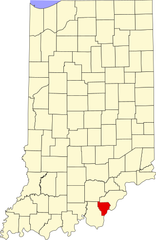
This is a list of the National Register of Historic Places listings in Floyd County, Indiana.

<span class="mw-page-title-main">National Register of Historic Places listings in Walton County, Georgia</span>

This is a list of properties and districts in Walton County, Georgia that are listed on the National Register of Historic Places (NRHP).

This is a list of properties and districts in Thomas County, Georgia that are listed on the National Register of Historic Places (NRHP).

<span class="mw-page-title-main">National Register of Historic Places listings in Muscogee County, Georgia</span>

This is a list of properties and districts in Muscogee County, Georgia that are listed on the National Register of Historic Places (NRHP).

<span class="mw-page-title-main">National Register of Historic Places listings in Baldwin County, Georgia</span>

This is a list of properties and districts in Baldwin County, Georgia that are listed on the National Register of Historic Places (NRHP).

<span class="mw-page-title-main">National Register of Historic Places listings in Gwinnett County, Georgia</span>

This is a list of properties and districts in Gwinnett County, Georgia that are listed on the National Register of Historic Places (NRHP).

This is a list of properties and districts in Clayton County, Georgia that are listed on the National Register of Historic Places (NRHP).

<span class="mw-page-title-main">National Register of Historic Places listings in Hall County, Georgia</span>

This is a list of properties and districts in Hall County, Georgia that are listed on the National Register of Historic Places (NRHP).

This is a list of properties and districts in Cobb County, Georgia that are listed on the National Register of Historic Places (NRHP).

This is a list of properties and districts in Rockdale County, Georgia that are listed on the National Register of Historic Places (NRHP).

This is a list of properties and districts in Richmond County, Georgia that are listed on the National Register of Historic Places (NRHP).

<span class="mw-page-title-main">National Register of Historic Places listings in Screven County, Georgia</span>

This is a list of properties and districts in Screven County, Georgia that are listed on the National Register of Historic Places (NRHP).

This is a list of properties and districts in Coweta County, Georgia that are listed on the National Register of Historic Places (NRHP).

This is a list of properties and districts in Newton County, Georgia that are listed on the National Register of Historic Places (NRHP).

<span class="mw-page-title-main">National Register of Historic Places listings in Pike County, Georgia</span>

This is a list of properties and districts in Pike County, Georgia that are listed on the National Register of Historic Places (NRHP).

This is a list of properties and districts in Haralson County, Georgia that are listed on the National Register of Historic Places (NRHP).

This is a list of properties and districts in Jenkins County, Georgia that are listed on the National Register of Historic Places (NRHP).

<span class="mw-page-title-main">National Register of Historic Places listings in Floyd County, Virginia</span>

This is a list of the National Register of Historic Places listings in Floyd County, Virginia.

References

  1. National Park Service, United States Department of the Interior, "National Register of Historic Places: Weekly List Actions", retrieved July 21, 2023.
  2. Numbers represent an alphabetical ordering by significant words. Various colorings, defined here, differentiate National Historic Landmarks and historic districts from other NRHP buildings, structures, sites or objects.
  3. The eight-digit number below each date is the number assigned to each location in the National Register Information System database, which can be viewed by clicking the number.