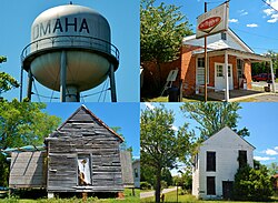
Omaha, Georgia

Last updated

Omaha, Georgia
Omaha, GA.jpg
Coordinates: 32°08′47″N85°00′48″W / 32.14639°N 85.01333°W / 32.14639; -85.01333
Country United States
State Georgia
Counties Stewart
Area
  Total184.9 sq mi (479 km2)
Population
 (July 2007)
  Total1,611
  Density8.7/sq mi (3.4/km2)
Time zone UTC-5 (Eastern (EST))
  Summer (DST) UTC-4 (EDT)
ZIP code
31821

Omaha is an unincorporated community in Stewart County, Georgia, United States.

Contents

Local Businesses

Omaha Brewing Company is located in Stewart County and owned by Omaha native Dr. Robert E. Lee and his wife, Stephanie Lee.

Geography

Omaha is located in the northwest corner of Stewart County near the juncture of the Chattahoochee River and Hannahatchee Creek. [2]

Georgia State Route 39 is the main road through the community, leading east 12 mi (19 km) to U.S. Route 27 near Louvale and south 22 mi (35 km) to Georgetown. Georgia State Route 39 Spur connects the community with the Alabama state line, approximately 2 mi (3.2 km) to the west across the Chattahoochee River.

Fitzgerald Cemetery is located about a mile outside of town. [3]

Florence Marina State Park is located outside of Omaha. The Roods Landing site is located south of Omaha.

History

Omaha was founded in the 1891 when the railroad arrived. [2]

The Georgia General Assembly incorporated Omaha as a town in 1891. [4] The town's municipal charter was dissolved in 1995. [5]

Fort McCreary

Located one mile north of Omaha, Fort McCreary was built in 1836 for the defense of Georgia´s frontier along the Chattahoochee River. During the Creek War of 1836 it was garrisoned by U.S. soldiers and Georgia Volunteers under command of a General McClesky. A relief column from the fort saved the day for Capt. Hamilton Garmany's company of Georgia militia during a battle on the Shepherd Plantation, the most aggressive Creek attack of the war. Three unknown soldiers lie buried on the crest of the fort, which is now owned by Roanoke chapter of the Daughters of the American Revolution. A period wooden blockhouse was reconstructed at the site of Fort McCreary in 1996.

Hanging over the bloody paper with Alf looking for spicy bits instead of attending to the general public. Picture of a butting match, trying to crack their bloody skulls, one chap going for the other with his head down like a bull at a gate. And another one: Black Beast Burned in Omaha, Ga. A lot of Deadwood Dicks in slouch hats and they firing at a Sambo strung up in a tree with his tongue out and a bonfire under him. Gob, they ought to drown him in the sea after and electrocute and crucify him to make sure of their job. [6]

Related Research Articles

<span class="mw-page-title-main">Talbot County, Georgia</span> County in Georgia, United States

Talbot County is a county located in the west central portion of the U.S. state of Georgia. The 2020 census showed a population of 5,733. The county seat and largest city is Talbotton.

<span class="mw-page-title-main">Sumter County, Georgia</span> County in Georgia, United States

Sumter County is a county located in the west-central portion of the U.S. state of Georgia. As of the 2020 census, its population was 29,616. The county seat is Americus. The county was created on December 26, 1831.

<span class="mw-page-title-main">Stewart County, Georgia</span> County in Georgia, United States

Stewart County is a county located in the west central portion of the U.S. state of Georgia. As of the 2020 census, the population was 5,314. The county seat is Lumpkin. The county was created on December 23, 1830.

<span class="mw-page-title-main">Muscogee County, Georgia</span> County in Georgia, United States

Muscogee County is a county located on the central western border of the U.S. state of Georgia named after the Muscogee that originally inhabited the land with its western border with the state of Alabama that is formed by the Chattahoochee River. As of the 2020 census, the population was 206,922. Its county seat and only city is Columbus, with which it has been a consolidated city-county since the beginning of 1971.

<span class="mw-page-title-main">Harris County, Georgia</span> County in Georgia, United States

Harris County is a county located in the west-central portion of the U.S. state of Georgia; its western border with the state of Alabama is formed by the Chattahoochee River. As of the 2020 census, the population was 34,668. The county seat is Hamilton. The largest city in the county is Pine Mountain, a resort town that is home to the Franklin D. Roosevelt State Park. Harris County was created on December 14, 1827, and named for Charles Harris, a Georgia judge and attorney.

<span class="mw-page-title-main">Douglas County, Georgia</span> County in Georgia, United States

Douglas County is a county located in the north central portion of the U.S. state of Georgia. As of the 2020 U.S. Census, the population was 144,237, having more than doubled since 1990. The county seat is Douglasville. The City of Villa Rica, and a small portion of Austell are both also located in Douglas County. Douglas County is included in the Atlanta-Sandy Springs-Roswell, GA Metropolitan Statistical Area. It has attracted new residents as jobs have increased in the Atlanta area.

<span class="mw-page-title-main">Crawford County, Georgia</span> County in Georgia, United States

Crawford County is a county located in the central portion of the U.S. state of Georgia. As of the 2020 census, the population was 12,130. The county seat is Knoxville.

<span class="mw-page-title-main">Cobb County, Georgia</span> County in Georgia, United States

Cobb County is a county in the U.S. state of Georgia, located in the Atlanta metropolitan area in the north central portion of the state. As of 2020 Census, the population was 766,149. It is the state's third most populous county, after Fulton and Gwinnett counties. Its county seat is Marietta; its largest city is Mableton.

<span class="mw-page-title-main">Chattahoochee County, Georgia</span> County in Georgia, United States

Chattahoochee County, also known as Cusseta-Chattahoochee County, is a county located on the western border in central Georgia. As of the 2020 census, the population was 9,565. The county seat is Cusseta, with which the county shares a consolidated city-county government. The city of Cusseta remains a geographically distinct municipality within Chattahoochee County. The county was created on February 13, 1854.

<span class="mw-page-title-main">Carroll County, Georgia</span> County in Georgia, United States

Carroll County is a county located in the northwestern part of the State of Georgia. As of the 2020 census, its population was 119,148. Its county seat is the city of Carrollton. Carroll County is included in the Atlanta-Sandy Springs-Roswell metropolitan statistical area and is also adjacent to Alabama on its western border.

<span class="mw-page-title-main">Fort Gaines, Georgia</span> City in Georgia, United States

Fort Gaines is a city in and the county seat of Clay County, Georgia, United States. It has a population of 1,107 as of the 2010 census.

<span class="mw-page-title-main">Gainesville, Georgia</span> City in Georgia, United States

Gainesville is a city and the county seat of Hall County, Georgia, United States. As of the 2020 census, the city had a population of 42,296. Because of its large number of poultry processing plants, it has been called the "Poultry Capital of the World." Gainesville is the principal city of the Gainesville, Georgia Metropolitan Statistical Area, which is included in the Atlanta–Sandy Springs–Gainesville, Georgia Combined Statistical Area.

<span class="mw-page-title-main">Columbus, Georgia</span> Consolidated city-county in the United States

Columbus is a consolidated city-county located on the west-central border of the U.S. state of Georgia. Columbus lies on the Chattahoochee River directly across from Phenix City, Alabama. It is the county seat of Muscogee County, with which it officially merged in 1970; the original merger excluded Bibb City, which joined in 2000 after dissolving its own city charter.

<span class="mw-page-title-main">Georgetown, Quitman County, Georgia</span> City in Georgia, United States

Georgetown is a city in Quitman County, Georgia, United States. It is on the Alabama-Georgia state line next to Walter F. George Lake and across the Chattahoochee River from Eufaula, Alabama. Per the 2020 census, the population was 2,235. In 2006, Georgetown and Quitman County voted to consolidate their governments, becoming the smallest such consolidated entity in the Lower 48 states.

<span class="mw-page-title-main">Chattahoochee River</span> River in Georgia, United States

The Chattahoochee River forms the southern half of the Alabama and Georgia border, as well as a portion of the Florida and Georgia border. It is a tributary of the Apalachicola River, a relatively short river formed by the confluence of the Chattahoochee and Flint rivers and emptying from Florida into Apalachicola Bay in the Gulf of Mexico. The Chattahoochee River is about 430 miles (690 km) long. The Chattahoochee, Flint, and Apalachicola rivers together make up the Apalachicola–Chattahoochee–Flint River Basin. The Chattahoochee makes up the largest part of the ACF's drainage basin.

Historic ferries operated on rivers around Atlanta, Georgia area, and became namesakes for numerous current-day roads in north Georgia. Most of the ferries date to the early years of European-American settlement in the 1820s and 1830s, when parts of the region were still occupied by cherokee and other Native American communities.

<span class="mw-page-title-main">Georgia State Route 39</span> State highway in Georgia, United States

State Route 39 is a 118-mile-long (190 km) state highway that travels south-to-north through portions of Seminole, Miller, Early, Clay, Quitman, and Stewart counties in the southwestern part of the U.S. state of Georgia. The route proceeds north from its southern terminus along the shore of Lake Seminole in southern Seminole County to a point just southwest of Omaha, where it travels in an easterly direction until it meets its northern terminus, an intersection with US 27/SR 1 in a rural south of the unincorporated community of Louvale.

<span class="mw-page-title-main">Roods Landing site</span>

The Roods Landing site or Roods Creek Mounds (9SW1) is an archaeological site located south of Omaha, Stewart County, Georgia, United States at the confluence of Rood Creek and the Chattahoochee River. It is a Middle Woodland / Mississippian period Pre-Columbian complex of earthen mounds. It was entered on the National Register of Historic Places on August 19, 1975.

<span class="mw-page-title-main">Columbus–Auburn–Opelika combined statistical area</span> CSA in the United States

The Columbus–Auburn–Opelika, GA–AL Combined Statistical Area is a trading and marketing area made up of six counties in Georgia and two in Alabama. The statistical area includes two metropolitan areas: the Columbus metropolitan area and the Auburn–Opelika metropolitan area. As of 2021, the CSA had a population of 503,709.

The Civil War Trust's Civil War Discovery Trail is a heritage tourism program that links more than 600 U.S. Civil War sites in more than 30 states. The program is one of the White House Millennium Council's sixteen flagship National Millennium Trails. Sites on the trail include battlefields, museums, historic sites, forts and cemeteries.

References

  1. U.S. Geological Survey Geographic Names Information System: Omaha, Georgia
  2. 1 2 Matthew M. Moye (December 12, 2011). "Stewart County". The New Georgia Encyclopedia. Georgia Humanities Council. Retrieved April 26, 2012.
  3. Richard Bernal. "Fitzgerald Family Cemetery". USGenWeb Project. Retrieved April 26, 2012.
  4. Acts Passed by the General Assembly of Georgia. J. Johnston. 1892. p. 823.
  5. Krakow, Kenneth K. (1975). Georgia Place-Names: Their History and Origins (PDF). Macon, GA: Winship Press. p. 167. ISBN   0-915430-00-2.
  6. James Joyce, Ulysses (Paris: Shakespeare and Company, 1922), pp. 314–15.