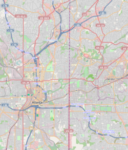
Decatur Waterworks | |
Location | 1400 McConnell Dr., Mason Mill Park, Decatur, Georgia |
---|---|
Coordinates | 33°48′28″N84°18′8″W / 33.80778°N 84.30222°W Coordinates: 33°48′28″N84°18′8″W / 33.80778°N 84.30222°W |
Area | 42 acres (17 ha) |
Built | 1906 |
NRHP reference No. | 06000123 [1] |
Added to NRHP | March 15, 2006 |
The Decatur Waterworks was a facility that obtained drinking water for the city of Decatur, Georgia, from the local Peachtree Creek and Burnt Fork Creek. Completed in 1907 and abandoned since the 1940s, the Waterworks have fallen into disrepair and are covered with graffiti. The Decatur Waterworks are in Mason Mill Park, near the city of Decatur. [2]
On March 15, 2006, the Decatur Waterworks was added to the National Register of Historic Places, due to its former industrial significance as a water works, its political importance as Works Progress Administration (WPA) project, and its use as a public park. [2]
Near Decatur Georgia, before the Civil War, in the 1850s, Ezekiel Mason built a flour mill on the bank of Burnt Fork Creek near where it flows into the south fork of Peachtree Creek. This is the mill from which Mason Mill Road and Mason Mill Park derive their names. After the deaths of Mr. Mason and his wife in the late 19th century the land was transferred to J. A. Mason, relationship unknown. The provenance of the property becomes unclear at that point as the DeKalb Historical Society notes show that the J. A. Mason sold the property to the City of Decatur, but Decatur City Council Minutes refer to the property as the "Tallery property", and an option was exercised with C. H. Talley for the purchase of land in October 1906. In any case, records show that a waterworks construction project was completed on the property by December 1907. [2]
By 1939, the Decatur Water Works consisted of two aeration and solid removal tanks, two storage tanks, an office building and two dams, one dam on South Peachtree Creek and one on Burnt Fork Creek. The remains of all of these structures can still be seen today and are often referred as ‘the old Decatur Water Works’. [2]
The Decatur Water Works supplied water to the city until the 1940s. Its use as a public park began in the 1930s when a Works Progress Administration (WPA) project built a number of recreational amenities on the site. These amenities included granite benches, cooking grills, tables and a stone bridge over Burnt Fork Creek. These things also can be seen today. The stone bridge is part of the new trail that has been recently constructed in the park. The WPA also built a stacked stone fountain that remains and can be seen very near the stone bridge. [2]
By 1941 it was apparent the 1.8 million US gallons (6,800 m3) of water per day produced by the water works was no longer enough to satisfy the growing needs of Decatur. The property was leased to DeKalb County, which operated the water works and sold the water to Decatur. DeKalb used revenue from the facility to fund a county-wide treatment plant in the Dunwoody area that uses water from the Chattahoochee River. Initially called the Laurel Plant, it is now called the Scott Candler Plant after the county commissioner who led the development process. [3]
During World War II the Decatur Water Works was used as the exclusive water supply for the Naval Air Station that is now Peachtree DeKalb Airport and an Army Hospital in the area. The property was declared off limits for civilian use and was not used for any recreational purpose or as a civilian water supply during the war. At the end of the war the water works land was returned to the City of Decatur and continued to be operated and maintained by the county as a backup for the new water system. The park area was not maintained and was not used by the public. [2]
For a time the office building at the water works was used for storage by the county. In 1951 a bond issue to finance development of the land was voted down. The water works fell into disuse and disrepair. By the mid-1960s the lakes had begun to fill with silt and there were complaints of flooding from local residents who lived in the adjacent neighborhoods that were built in the 1950s and 1960s. In about 1965 the dams were dynamited and the reservoirs drained. [2] [3]
In 1988 the county worked with local resident groups to make a development plan for Mason Mill Park that included the water works land, but the plan was never funded. In 2006 the Decatur Water Works was declared a historic site. A second plan was developed in 2008 and, with partial funding from the PATH Foundation, is being implemented. [4]
DeKalb County is located in the north central portion of the U.S. state of Georgia. As of the 2010 census, the population was 691,893, making it Georgia's fourth-most populous county. Its county seat is Decatur.
Decatur is a city in, and the county seat of, DeKalb County, Georgia, which is part of the Atlanta metropolitan area. With a population of 19,335 in the 2010 census, the municipality is sometimes assumed to be larger since multiple ZIP Codes in unincorporated DeKalb County bear Decatur as the address. The city is served by three MARTA rail stations. The city is located approximately 5 miles (8.0 km) northeast of Downtown Atlanta and shares its western border with both the city of Atlanta and unincorporated DeKalb County. The Druid Hills neighborhood is to the northwest of Decatur. The unofficial motto of Decatur used by some residents is "Everything is Greater in Decatur."
Druid Hills is a community which includes both a census-designated place (CDP) in unincorporated DeKalb County, Georgia, United States, as well as a neighborhood of the city of Atlanta. The CDP's population was 14,568 at the 2010 census. The CDP formerly contained the main campus of Emory University and the Centers for Disease Control and Prevention (CDC); they were annexed by Atlanta in 2018. The Atlanta-city section of Druid Hills is one of Atlanta's most affluent neighborhoods with a mean household income in excess of $238,500.
North Decatur is a census-designated place (CDP) in DeKalb County, Georgia, United States. The population was 16,698 at the 2010 census.
North Druid Hills, also known as Briarcliff, is an unincorporated community and census-designated place in DeKalb County, Georgia, United States. The population was 18,947 at the 2010 census. The commercial center of the area is the Toco Hill Shopping Center, located near the intersection of North Druid Hills Road and Lavista Road.
Tucker is a city located in DeKalb County, Georgia located near Atlanta and was originally settled in the 1820s, and later developed as a railroad community in 1892. According to the 2016 United States Census Bureau annual estimate of resident population, it has a population of 35,322. In a November 2015 referendum, by a 3:1 margin (73.94%), voters approved incorporating Tucker into a city. In March 2016, Tucker residents elected the city's first mayor and city council.
The Chattahoochee River forms the southern half of the Alabama and Georgia border, as well as a portion of the Florida - Georgia border. It is a tributary of the Apalachicola River, a relatively short river formed by the confluence of the Chattahoochee and Flint rivers and emptying from Florida into Apalachicola Bay in the Gulf of Mexico. The Chattahoochee River is about 430 miles (690 km) long. The Chattahoochee, Flint, and Apalachicola rivers together make up the Apalachicola–Chattahoochee–Flint River Basin. The Chattahoochee makes up the largest part of the ACF's drainage basin.
There were several historic mills around the metro Atlanta area, for which many of its current-day roads are still named. Most of the mills date back to the 1820s and 1830s, and were built along the area's many streams. The locations of many of these mills are shown on a map of 1875 showing U. S. military operations around Atlanta in 1864. This map is now located in the U. S. Library of Congress but can be seen on the webpage linked here.
Rock Island State Park is a state park in Warren County and White County, Tennessee, located in the Southeastern United States. The park is named after the community of Rock Island, Tennessee, which in turn received its name from an island on the Caney Fork upstream from the Collins River confluence and Great Falls Dam. Rock Island State Park is centered on a peninsula created by the confluence of these two rivers and extends downstream to the headwaters of Center Hill Lake.
Rensselaer Lake is an artificial lake in Albany, New York, United States named for Major-General Stephen Van Rensselaer, last patroon of Rensselaerswyck. The lake was Albany's first municipally-owned source of water. It is part of a 57-acre (23 ha) park and the state's Albany Pine Bush Preserve. The lake and park have been under the purview of the Albany Water Authority since 2003.
The New Milford Plant of the Hackensack Water Company was a water treatment and pumping plant located on Van Buskirk Island, an artificially created island in the Hackensack River, in Oradell, Bergen County, New Jersey, United States. The site was purchased in 1881 by the Hackensack Water Company, which developed it for water supply use. The facility was built between 1881 and 1911, and it includes a brick pumping station from 1882, a tall filtration tower, and huge underground infrastructure. The Hackensack Water Company was merged into United Water in the 1980s; the successor today is Suez North America.
The DeKalb County School District (DCSD) is a school district headquartered at 1701 Mountain Industrial Boulevard in unincorporated DeKalb County, Georgia, United States, near Stone Mountain and in the Atlanta metropolitan area. DCSD operates public schools in areas of DeKalb County that are not within the city limits of Atlanta and Decatur. It will serve a portion of Atlanta annexed by that city in 2018 until 2024, when that portion will be re-assigned to Atlanta Public Schools (APS).
Ponce de Leon Avenue, often simply called Ponce, provides a link between Atlanta, Decatur, Clarkston, and Stone Mountain, Georgia. It was named for Ponce de Leon Springs, in turn from explorer Juan Ponce de León, but is not pronounced as in Spanish. Several grand and historic buildings are located on the avenue.
Winnona Park is a historic area in the southeast corner of the Atlanta, Georgia neighborhood of Decatur. It is listed as a historic district on the National Register of Historic Places, but it is not one of the City of Decatur's locally designated historic districts.
Glennwood Estates is a historic neighborhood located in the northeast section of Decatur, Georgia. It is a residential neighborhood chiefly of single-family homes including a nature preserve and an adjoining park. At least a third of the homes were build in the 1920s and were relatively large for the time. Glenn Creek and the South Fork of Peachtree Creek Tributary run through the neighborhood.
Chelsea Heights and Westchester Hills are adjacent neighborhoods, separated by a municipal park, in the northwest corner of the Atlanta, Georgia suburb of Decatur. Chelsea Heights straddles the east and west sides of the CSX railroad tracks, falling within the City of Decatur and the unincorporated DeKalb County, respectively. The latter part, though located east of what historically was Druid Hills, is part of the Druid Hills CDP and participates in the Druid Hills Civic Association: see Chelsea Heights.
The Decatur Cemetery is a historic graveyard within the City of Decatur, Georgia.
Murphey Candler Park is a 135-acre multi-use park located in Brookhaven, Georgia, United States. The park is owned and operated by the City of Brookhaven. Park amenities include multi-use fields, tennis courts, a swimming pool, a playground, picnic areas, a lake, and trails. Youth sports are offered through baseball, softball, and football programs that operate through the park. The lake at Murphey Candler Park offers fishing, and it is home to largemouth bass, bluegill, redear sunfish, and channel catfish. The lake is also home to Canada Geese, Mallards, other ducks and beavers.
The Swanton House is a historic building in downtown Decatur, Georgia and is one of a very few pre-Civil War buildings in the area which are still standing. It was entered into the National Register of Historic Places on August 30, 1978.
The Peachtree Creek Greenway trail is a multi-use trail under construction along the North Fork Peachtree Creek in and near Atlanta, Georgia, United States, which will traverse the cities of Atlanta, Brookhaven, Chamblee, Doraville and parts of Unincorporated Dekalb County. Once complete, it will connect 12 miles from the Atlanta Beltline trails and Path 400 northward up to I-285. Some landmarks along the route will include Silverback stadium, Mercer University, CHOA & Emory and multiple schools and libraries.