Atlanta freeway revolts

Last updated

Unbuilt freeways in Atlanta in red:
East-west routes: Stone Mountain Fwy at top, Langford Pkwy at bottom.
North-south route: I-485/GA400 Unbuilt freeways in atlanta.jpg
Unbuilt freeways in Atlanta in red:
East-west routes: Stone Mountain Fwy at top, Langford Pkwy at bottom.
North-south route: I-485/GA400
1970 map of proposed route of I-485 through northeast Atlanta 1970 I-485-map.jpg
1970 map of proposed route of I-485 through northeast Atlanta

There have been multiple freeway revolts in Atlanta, Georgia. The longest and most famous examples of Interstate opposition were against I-485 and the Stone Mountain Freeway through Intown Atlanta, lasting over 30 years, from the early 1960s until the final construction of Freedom Parkway on a small portion of the contested routes in 1994. [1]

Contents

I-485 and Stone Mountain Freeways

Proposed freeways in intown Atlanta.jpg

Location

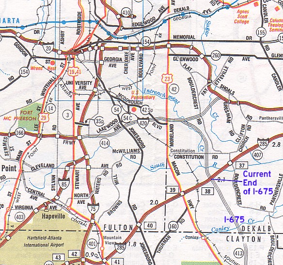
The original plans for the Atlanta freeway system (map, p.2 [ permanent dead link ]) included several freeways that were never built.

One was a north-south freeway parallel to, and 2–3 miles (3.2–4.8 km) east of today's Downtown Connector (I-75/85), connecting the southern end of today's Georgia 400 with I-675 at the southeast Perimeter.

Another was the east-west Stone Mountain Freeway, which:

  • Would have begun in Downtown Atlanta and followed today's Freedom Parkway eastwards to Copenhill and the interchange with the north-south freeway
  • Continued eastwards parallel to Ponce de Leon Avenue and Scott Boulevard until the northeast Perimeter, where it would have continued as today's Stone Mountain Freeway

Portions of the two highways were to bear the number I-485: the east-west highway from Downtown to Copenhill, and the north-south highway from Copenhill north to I-85.

Plans for new freeways

In 1964 the Georgia Highway Department (GHD) announced plans to build I-485. In May 1965, the Morningside Lenox Park Association (MLPA) was formed to fight the highway. MLPA hired planners who suggested an alternate route E, (map) roughly along the BeltLine from Ponce de Leon Avenue north to Ansley Mall and from there alongside Piedmont Road north to today's I-85/GA-400 interchange. In July 1965 a dueling civic association, the Morningside Monroe Civic Association (MMCA), was formed to fight Route E. In February 1966 the highway department definitively chose the original route (route B) through Morningside. [2]

MLPA filed a lawsuit in October 1966 to try to stop construction and was denied; the appeal was denied in June 1967.

Success in stopping construction

Nonetheless the road was eventually stopped.

  • During 1967–1970, the MLPA negotiated design changes with GHD, which bought time, and in 1971 another lawsuit was filed, this time via a PAC (neighborhood activists Virginia Taylor, Adele Northrup, Mary Davis, and Barbara Ray were instrumental in these efforts)
  • National events creating momentum against further freeway construction in established residential areas:
  • From 1971–73 the Georgia DOT was headed by Carter's friend Bert Lance, who continued to fight for freeway construction and who would later be involved in scandal while serving as director of the OMB [3]
  • In Fall 1971 Virginia Highland residents led by Joseph Drolet founded the Virginia Highland Civic Association (VHCA) to fight the road, and a coalition was formed with residents of Inman Park and other neighborhoods
  • In November 1971 the Atlanta Board of Aldermen rescinded their previous support for I-485 (Bert Lance appealed to them to reverse their stance); [4] in June 1973 the aldermen strengthened their stance and passed a motion to actively oppose it
  • In 1972 then-vice-mayor Maynard Jackson opposed the highway while running for mayor
  • In March 1973 Governor Jimmy Carter signed a new city charter for Atlanta, including an "Environmental Bill of Rights" that Adele Northrup has authored; nonetheless Carter remained suspected of support for the freeway as late as August 1973. [5]
  • In June 1973 the federal DOT rejected the GHD's environmental impact study, citing its underassessment of impact on intown neighborhoods
  • In 1975 Governor George Busbee instructed the GHD to remove I-485 from its long term plan – this was considered I-485's definitive death knell.

The result

The freeway revolt strengthened neighborhood organizations in Atlanta, which to this day exert relatively more influence in city decisions compared to other major US cities. [6]

Portions of the right of way where houses had been razed were used for parks: Sidney Marcus Park in Morningside, John Howell Memorial Park in Virginia Highland, and Freedom Park at the current eastern terminus of Freedom Parkway.

The use of the north-south corridor for a road was a dead concept until GDOT brought it up again in 2010 in the form of a tunnel (see below); the discussion around a road in the east-west corridor was, however, to continue for another two decades.

Jimmy Carter's "Presidential Parkway"

Plaque about CAUTION in Freedom Park just south of Ponce de Leon Ave. CautionFreedomPark.jpg
Plaque about CAUTION in Freedom Park just south of Ponce de Leon Ave.

The land that was to become the east-west freeway lay empty through the 1980s as residents fought the construction of any road in the corridor. A "Presidential Parkway" was proposed as a smaller four-lane road to run from Downtown far into Druid Hills (see map).

Citizens of neighborhoods along the corridor formed CAUTION (Citizens Against Unnecessary Thoroughfares in Older Neighborhoods) raised over $800,000 [7] to fight the proposed Presidential Parkway which would have been an elevated multi-lane highway with limited access. [8]

Flyer used by CAUTION in opposition to the Presidential Parkway CAUTION flyer.png
Flyer used by CAUTION in opposition to the Presidential Parkway

In 1981, ex-President Carter revived the idea of a highway along the east-west route to serve his planned presidential library and policy center on Copenhill. Carter originally bought only several acres of land. However the GDOT leased him 29 more acres in exchange for backing GDOT plans for a 2.9 mile east-west expressway, on the condition that if the road were not built, the Center would lose the land, i.e. its parking and gardens. Carter lobbied and won support from Mayor Young, the City Council and Chamber of Commerce. The road would connect the new Carter Center with downtown on the west, and to Druid Hills (and thus access to Emory University) to the east. [9] In 1984, Carter broke ground on the center, and construction resumed on the new "Presidential Parkway".

According to the environmental impact statement for the Presidential Parkway would have used land from four parks, a neighbourhood on the National Register of Historic Places, and a neighbourhood eligible to be on that registry. Their report also noted that the parkway would go over neighbourhoods that represent a broad range of demographics including upper income areas as well as lower income predominantly african american areas. [10]

However, CAUTION lobbied until 1991 to fight the Jimmy Carter-backed Expressway. In the end, only Jimmy Carter and GDOT supported a "Presidential Parkway". CAUTION, Lieutenant Governor Pierre Howard (D-Decatur), Mayor Maynard Jackson, and a majority of councilpersons were opposed, as well as elected officials at the county, state and federal levels. Only the announcement that Atlanta would host the 1996 Olympics broke the stalemate. Court-ordered mediation between representatives of GDOT, the City of Atlanta and CAUTION, reached a mediated settlement to an at-grade, meandering parkway surrounded by parkland. In 1991, compromise forged by Lt. Governor Howard and DOT Commissioner Wayne Shackleford was reached to build the road as it exists today, and to the choice of the name "Freedom Parkway", in theory because it links the Carter Center with the Martin Luther King historic district. [11]

During this time the term "Great Park" was also used to refer to the corridor.

Eventually the four-lane Freedom Parkway was built from Downtown to Copenhill only, ending in a northern stub to Ponce de Leon Avenue near Barnett in Virginia Highland, and an eastern stub to Moreland Avenue in Poncey Highland at the Druid Hills border. Largely due to the efforts of Druid Hills, Inman Park, Candler Park, Lake Claire and Poncey Highland residents, who filed a lawsuit, [12] the right-of-way east of Moreland became a park but without a roadway.

In 1984 Steve Williams started documenting the Presidential Parkway as the construction started, resulting in a photography series and a model built of Freedom Park in the City Hall Atrium after the compromise was reached in 1991. This photography show was supported by a grant by the City of Atlanta Bureau of Cultural Affairs and the Dept of Planning. More grants were awarded to support the work and other events were covered in the park such as Art in Freedom Park in 2005, a summer long arts festival and Naked Freedom, a naked frolic in the park. Other art created for the park was "Decade: 1992 and 2002", a series of photographs, with the original model of the park, sponsored by Don Bender showing the change of the land from 1992 to 2002. Another decade later, the "Decades:1992, 2002, 2012" exhibit went on display throughout Freedom Park to show the further change over those 20 years.

Eastern part of Lakewood Freeway/Langford Parkway

Langford Parkway, originally called the Lakewood Freeway (I-420) – now part of Georgia 166 – was to be built eastwards past its current terminus at the southern end of the Downtown Connector to connect to the north-south I-675 route, and then to meet I-20 near Gresham Park in south DeKalb (map of proposed route).

2010 plan for I-675

In 2010 a freeway to link GA-400 at Lindbergh with I-675 at the southeast Perimeter, again appeared on GDOT's list of potential projects, this time in the form whereby the intown portion would be in a 14.6-mile-long, 41-foot-wide tunnel. The Reason Foundation had first advocated for such a tunnel in 2006, proposing that it would be paid as part of larger plan to reduce congestion via tolls. [13] Rep. Pat Gardner held a meeting at Rock Springs Church in Morningside on January 4, 2010 with GDOT and Atlanta Regional Commission (ARC) leaders, Mayor Kasim Reed, city councilmembers and assemblypersons. ARC Chairman Tad Leithead, while still wishing to study the proposal, noted preliminary evidence of a funding gap, very high ($8) tolls and a shortfall in traffic lanes, making it appear that the project "doesn't make any sense". This elicited cheers from the audience. Mayor Reed expressed his total opposition to the tunnel. [14] [15] As of August 2022, this proposal is not on GDOT's Major Mobility Investment Project list. [16]

Related Research Articles

In Downtown Atlanta, the Downtown Connector or 75/85 is the concurrent section of Interstate 75 and Interstate 85 through the core of the city. Beginning at the I-85/Langford Parkway interchange, the Downtown Connector runs generally due north, meeting the west–east I-20 in the middle. Just north of this is the Grady Curve around Grady Memorial Hospital. Continuing north, the terminus of the Downtown Connector is the Brookwood Interchange or Brookwood Split in the Brookwood area of the city. The overall length of the Downtown Connector is approximately 7.5 miles (12 km). Since the 2000s, it has been officially named James Wendell George Parkway for most of its length, although it is still designated the Connector in the mainstream. It also has unsigned designations State Route 401 (I-75) and State Route 403 (I-85) along its length, due to I-75 and I-85 having 400-series reference numbers.

<span class="mw-page-title-main">Interstate 285 (Georgia)</span> Interstate Highway in Georgia, United States

Interstate 285 (I-285) is an auxiliary Interstate Highway encircling Atlanta, Georgia, for 63.98 miles (102.97 km). It connects the three major Interstate Highways to Atlanta: I-20, I-75, and I-85. Colloquially referred to as the Perimeter, it also carries unsigned State Route 407 (SR 407) and is signed as Atlanta Bypass on I-20, I-75, and I-85.

<span class="mw-page-title-main">Georgia State Route 400</span> North-south highway in U.S. state of Georgia

Georgia State Route 400 is a freeway and state highway in the U.S. state of Georgia serving parts of Metro Atlanta. It is concurrent with U.S. Route 19 (US 19) from exit 4 (Interstate 285) until its northern terminus south-southeast of Dahlonega, linking the city of Atlanta to its north-central suburbs and exurbs. SR 400 travels from the Lindbergh neighborhood in the Buckhead district of Atlanta, at Interstate 85 (I-85), to just south-southeast of Dahlonega. Like the Interstate highways, it is a limited-access road, but unlike the interstates, the exit numbers are not mileage-based, they are sequential. Once SR 400 passes exit 18 (SR 369), it changes from a limited-access freeway into an at-grade divided highway with traffic lights, but still with a high speed limit of 65 miles per hour (105 km/h), and ends at the J.B. Jones Intersection at SR 60/SR 115 in Lumpkin County.

Stone Mountain Freeway is a freeway in the north-central part of the U.S. state of Georgia. It connects Interstate 285 (I-285) east of Atlanta, with the suburbs of Stone Mountain and Snellville before transitioning into an arterial road that continues to Athens. The freeway is signed as U.S. Route 78 (US 78) for its entire length, with the western half signed as State Route 410 (SR 410), and the eastern half also being signed as SR 10. It begins at the US 29/US 78 split northeast of Decatur, and continues east through eastern DeKalb and southern Gwinnett counties. The portion of Stone Mountain Freeway from I-285 to the Dekalb/Gwinnett county line is alternatively designated as Bill Evans Highway.

<span class="mw-page-title-main">Interstate 575</span> Highway in Georgia

Interstate 575 (I-575) is an auxiliary Interstate Highway in the United States, which branches off I-75 in Kennesaw and connects the Atlanta metropolitan area with the North Georgia mountains, extending 30.97 miles (49.84 km). I-575 is also the unsigned State Route 417 (SR 417) and is cosigned as SR 5. I-575 begins in northern Cobb County near Kennesaw and goes mostly through Cherokee County, ending at its northern border with Pickens County, where it continues as SR 515. It is also the Phillip M. Landrum Memorial Highway in honor of Phillip M. Landrum (1907–1990), who was a Representative from Georgia. It is entirely concurrent with Georgia State Route 5.

<span class="mw-page-title-main">Georgia State Route 141</span> Highway in Georgia

State Route 141 (SR 141) is a 34.1-mile-long (54.9 km) state highway that runs southwest-to-northeast in the northwest part of the U.S. state of Georgia. It connects the Buckhead area of Atlanta with Cumming. Its routing exists within portions of Fulton, DeKalb, Gwinnett, Forsyth counties.

<span class="mw-page-title-main">Inman Park</span> Historic district on the east side of Atlanta, Georgia, United States

Inman Park is an intown neighborhood on the east side of Atlanta, Georgia, and its first planned suburb. It was named for Samuel M. Inman.

<span class="mw-page-title-main">Interstate 675 (Georgia)</span> Highway in Georgia

Interstate 675 (I-675) is an 11.04-mile-long (17.77 km) auxiliary Interstate Highway in the southeast part of the Atlanta metropolitan area. It travels from I-75 in Stockbridge in the south to I-285 in the north. I-675 is also designated as the Terrell Starr Parkway and also has the unsigned internal state route designation of State Route 413 (SR 413).

<span class="mw-page-title-main">Poncey–Highland</span> Neighborhoods of Atlanta in Fulton County, Georgia, United States

Poncey–Highland is an intown neighborhood on the east side of Atlanta, Georgia, located south of Virginia–Highland. It is so named because it is near the intersection of east/west Ponce de Leon Avenue and north/southwest North Highland Avenue. This Atlanta neighborhood was established between 1905 and 1930, and is bordered by Druid Hills and Candler Park across Moreland Avenue to the east, the Old Fourth Ward across the BeltLine Eastside Trail to the west, Inman Park across the eastern branch of Freedom Parkway to the south, and Virginia Highland to the north across Ponce de Leon Avenue. The Little Five Points area sits on the border of Poncey–Highland, Inman Park, and Candler Park.

<span class="mw-page-title-main">Jimmy Carter Library and Museum</span> Library in Atlanta, Georgia, US

The Jimmy Carter Library and Museum in Atlanta, Georgia, houses U.S. President Jimmy Carter's papers and other material relating to the Carter administration and the Carter family's life. The library also hosts special exhibits, such as Carter's Nobel Peace Prize and a full-scale replica of the Oval Office as it was during the Carter Administration, including a reproduction of the Resolute desk.

<span class="mw-page-title-main">Virginia–Highland</span> Neighborhoods of Atlanta in Fulton County, Georgia, United States

Virginia–Highland is an affluent neighborhood of Atlanta, Georgia, founded in the early 20th century as a streetcar suburb. It is named after the intersection of Virginia Avenue and North Highland Avenue, the heart of its trendy retail district at the center of the neighborhood. The neighborhood is famous for its bungalows and other historic houses from the 1910s to the 1930s. It has become a destination for people across Atlanta with its eclectic mix of restaurants, bars, and shops as well as for the Summerfest festival, annual Tour of Homes and other events.

<span class="mw-page-title-main">Interstate 485 (Georgia)</span> Former proposed highway in Georgia

Interstate 485 (I-485) was a proposed auxiliary Interstate Highway that would have traveled eastward and then northward from Downtown Atlanta, in the US state of Georgia.

<span class="mw-page-title-main">Georgia State Route 10</span> State highway in central Georgia

State Route 10 (SR 10) is a 172.3-mile-long (277.3 km) state highway in the U.S. state of Georgia. It travels from Downtown Atlanta to the South Carolina state line in Augusta. This highway, along with U.S. Route 78 (US 78), connect three of the biggest metro areas of the state together: Atlanta, Athens, and Augusta. It travels concurrently with US 78 in three sections: from Atlanta to Druid Hills; from near Stone Mountain to near Athens; and from Athens to its eastern terminus, for a total of 149.2 miles (240.1 km), or approximately 86.6 percent of its route.

<span class="mw-page-title-main">Interstate 85 in Georgia</span> Section of Interstate Highway in Georgia, United States

Interstate 85 (I-85) is a major Interstate Highway that travels northeast–southwest in the US state of Georgia. It enters the state at the Alabama state line near West Point, and Lanett, Alabama, traveling through the Atlanta metropolitan area and to the South Carolina state line, where it crosses the Savannah River near Lake Hartwell. I-85 connects North Georgia with Montgomery, Alabama, to the southwest, and with South Carolina, North Carolina, and Virginia to the northeast. Within Georgia, I-85 is also designated as the unsigned State Route 403 (SR 403).

<span class="mw-page-title-main">Outer Perimeter</span> Highway in Georgia

The Outer Perimeter is a freeway originally planned to encircle Atlanta, in the U.S. state of Georgia about 20 to 25 miles outside of Interstate 285, which is colloquially referred to as the Perimeter and is a point of reference for local travel outside Atlanta's city core.

<span class="mw-page-title-main">Freedom Park (Atlanta, Georgia)</span>

Freedom Park is one of the largest city parks in Atlanta, Georgia, United States. The park forms a cross shape with the axes crossing at the Carter Center. The park stretches west-east from Parkway Drive, just west of Boulevard, to the intersection with the north-south BeltLine Eastside Trail, to Candler Park, and north-south from Ponce de Leon Avenue to the Inman Park/Reynoldstown MARTA station.

<span class="mw-page-title-main">Morningside/Lenox Park</span>

Morningside/Lenox Park is an intown neighborhood in Atlanta, Georgia founded in 1923. It is located north of Virginia-Highland, east of Ansley Park and west of Druid Hills. Approximately 3,500 households comprise the neighborhood that includes the original subdivisions of Morningside, Lenox Park, University Park, Noble Park, Johnson Estates and Hylan Park.

The History of Virginia–Highland, the Intown Atlanta neighborhood, dates back to 1812, when William Zachary bought and built a farm on 202.5 acres (0.819 km2) of land there. At some point between 1888 and 1890 the Nine-Mile Circle streetcar arrived,, making a loop of what are now Ponce de Leon Avenue, North Highland Avenue, Virginia Avenue, and Monroe Drive. Atlantans at first used the line to visit what was then countryside, including Ponce de Leon Springs, but the line also enabled later development in the area. Residential development began as early as 1893 on St. Charles and Greenwood Avenues, must most development took place from 1909 through 1926 — solidly upper-middle class neighborhoods, kept all-white by covenant.

<span class="mw-page-title-main">Highland Avenue (Atlanta)</span>

Highland Avenue, east of the BeltLine North Highland Avenue, is a major thoroughfare in northeast Atlanta, forming a major business corridor connecting five Intown neighborhoods:

Veterans Parkway is a 6.1-mile (9.8 km) long freeway in the Savannah metropolitan area, connecting Georgetown with downtown Savannah, completely within Chatham County. It is not a state route, nor is it maintained by the Georgia Department of Transportation (GDOT); it is one of a handful of county-maintained freeways in Georgia. Other county maintained freeways include Ronald Reagan Parkway, Harry S. Truman Parkway, and a portion of the East–West Connector in Cobb County. Most of the route parallels Hunter Army Airfield, which is located to the east of the highway. At its northern terminus, Interstate 516 (I-516) east and State Route 21 (SR 21) south provides access to Hunter AAF. On SR 204 it is not signed as Veterans Parkway, it is signed "Downtown Savannah".

References

  1. "Metrospective", September 18, 1994, Atlanta Journal-Constitution, Page: F/1
  2. Hall, Van (2003). "The Interstate That Almost Was" (PDF). Morningside-Lenox Park Association. Archived (PDF) from the original on September 11, 2022. Retrieved September 11, 2022.
  3. "Jimmy Carter" By Julian E. Zelizer, Arthur M. Schlesinger, Sean Wilentz
  4. "Atlanta road work suspended", Spartanburg Herald-Journal, November 18, 1971
  5. "Carter under fire on plan for interstate", Rome News-Tribune, August 8, 1973
  6. "The Interstate that Almost Was" [ permanent dead link ], MLPA News, Fall 2003
  7. Wright, Paul H. (2002). Introduction to engineering (3rd ed.). New York. p. 227. ISBN   0-471-05920-X. OCLC   47764350.{{cite book}}: CS1 maint: location missing publisher (link)
  8. T road's end: Transportation and land use choices for communities, Authors:Daniel Carlson, Surface Transportation Policy Project
  9. "Dispute over road location stalls plan for Carter Library", Spokesman-Review, December 16, 1981
  10. Planning Atlanta Planning Publications Collection, Georgia State University Library. 1983. atlpp0363. Presidential parkway, Atlanta, Georgia: project M-9152(2) Fulton/Dekalb counties, draft environmental impact statement. https://digitalcollections.library.gsu.edu/digital/collection/PlanATL/id/45728
  11. "Carter Center, Neighbors Agree To End Atlanta's Bitter Road War", Orlando Sentinel, September 29, 1991
  12. "Rehearing and Rehearing En Banc Denied Oct. 28, 1985". Archived from the original on May 15, 2010. Retrieved April 25, 2011.
  13. "Reducing Congestion in Atlanta: A Bold New Approach to Increasing Mobility", The Galvin Mobility Project, By Robert W. Poole, Jr. – see pp.28–29
  14. Reed against Atlanta tunnel, Atlanta Journal-Constitution, January 5, 2010
  15. "DOT: Atlanta opposition to tunnel does not kill idea", Atlanta Journal-Constitution, January 6, 2010
  16. "Major Mobility Investment Project: Home". Georgia Department of Transportation. April 22, 2019. Archived from the original on August 15, 2022. Retrieved August 15, 2022.

I-485 and Stone Mountain Freeway

Presidential Parkway and Freedom Parkway

New proposals for north-south tunnel