This article is about the first-generation 19th and 20th century streetcar system in Atlanta. For the modern Downtown Loop streetcar line opened in 2014, see Atlanta Streetcar.
A view of a horsecar on Peachtree Street in 1882Atlanta streetcar, 1910. Pay-as-you-enter cars were being introduced at the time
Streetcars in Atlanta originally operated between Downtown Atlanta and the surrounding areas from 1871 until the final line's closure in 1949.
The first such transportation began with horsecars in 1871, and electric streetcar service started in the 1880s.[1] In addition to streetcars in Atlanta proper, there were also interurban railways from Atlanta to outlying towns. The last streetcar service on the old network ended in 1949; the streetcar system was quickly replaced by a trolleybus system and with buses.
After decades of planning, construction of a new streetcar system, the Atlanta Streetcar, began in early 2012.[2] Consisting initially of a single route, this new streetcar line opened in December 2014. Planning for a larger network, including on an abandoned loop of intown rail tracks now known as the Beltline is under way.
Streetcars 1871–1949
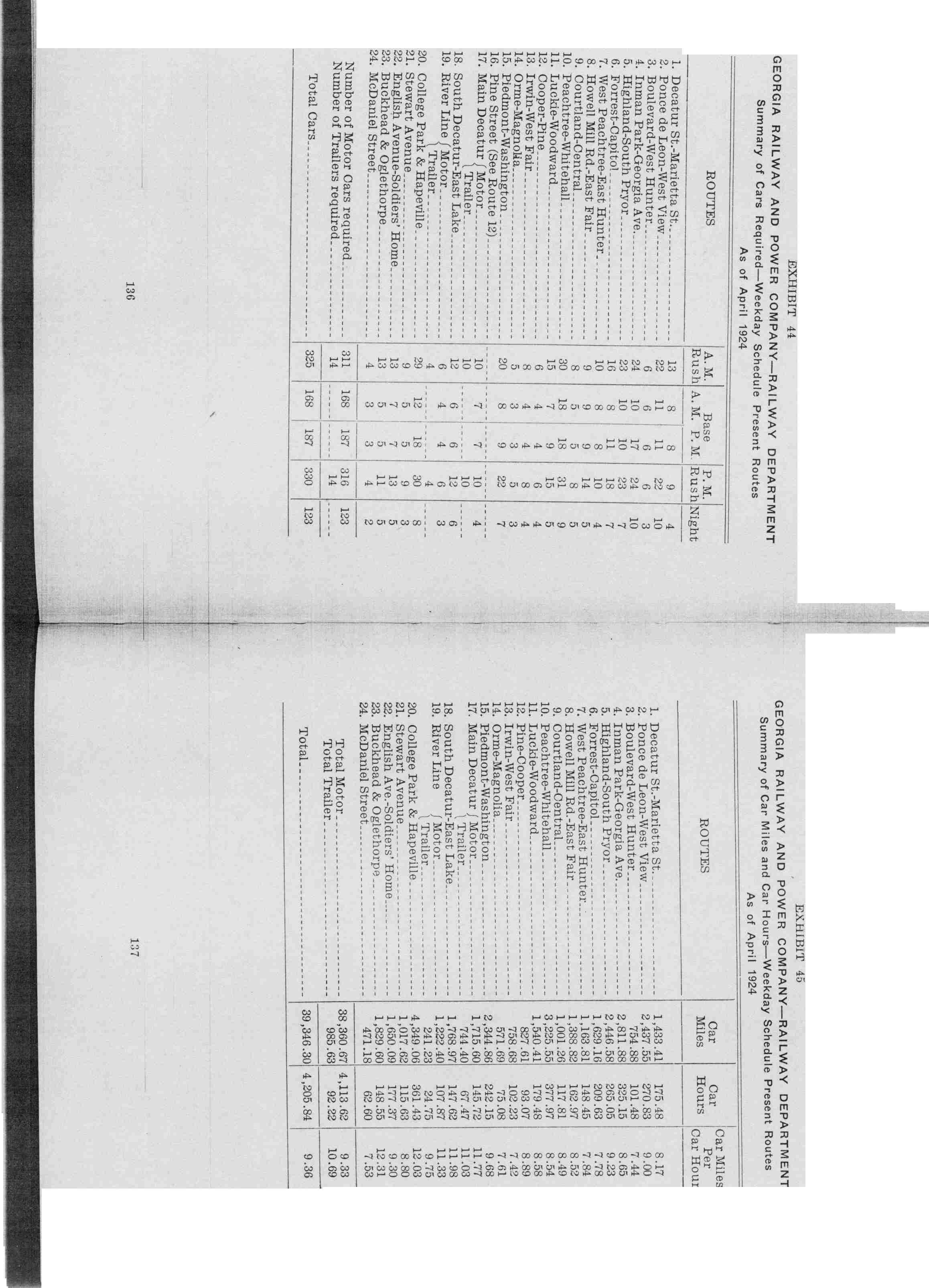
Map of Atlanta's streetcar system in 1924Map of Atlanta's streetcar system and other transit in 1946
1890 Atlanta, West End & McPherson Barracks Ry. Co. began, powered by the electric Sprague system[3]
1891 Law passed requiring segregation on streetcars "as much as practicable" and at the enforcement of streetcar conductors.[4] Prior to this, it was common for Black and white passengers to sit next to each other on streetcars.[5]
A much longer route along Peachtree Street, the city's main street. Originally, the line was to run from the Oakland City neighborhood through Downtown Atlanta, Midtown and Buckhead. However a more recent (2010) pared-down proposal would run between the Arts Center MARTA station in Midtown and the Five Points MARTA station downtown.[8] In 2015, Buckhead business leaders and city councilpersons successfully had the portion of along Peachtree Rd, from Piedmont Hospital to Lenox Mall, removed from the long range plan.
Beltline routes
Streetcar routes that would have been funded by 1-cent sales tax, which was voted down in July 2012
In July 2012, there was a referendum on a 1-cent sales tax (SPLOST) to fund traffic and road improvements. If it had been approved, the tax would have funded several streetcar routes along portions of the Beltline trail and connections onto MARTA stations and with the Downtown Loop streetcar. The final list of projects to have been funded included 2 routes:[9]
Midtown to Northeast: from North Ave. MARTA station (1) east along North Ave. to the Beltline, then north along Beltline to 10th and Monroe (southeast corner of Piedmont Park) (2) and south to Edgewood St. (3) and connection to the Downtown streetcar at its eastern terminus (which would be extended from it current proposed terminus at Jackson St.)
Downtown/Midtown to Southwest:
branch from North Ave. station to Luckie St. (4)
branch from the western terminus of the Downtown streetcar at Centennial Olympic Park/CNN to Luckie St. (4)
The proposal was defeated in the 10-county Metro Atlanta region, as a region 63% against and 37% for.[13] In Fulton and DeKalb Counties the results were 52% against and 48% for.
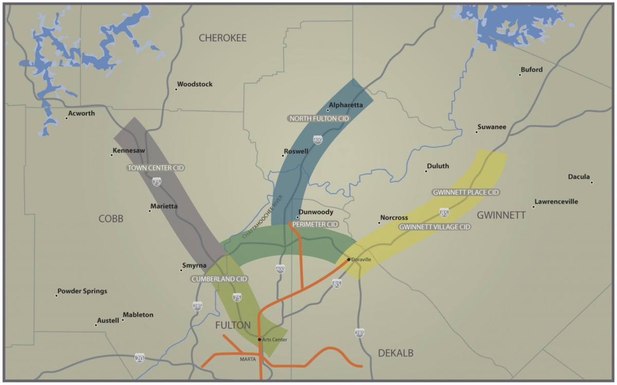
In June 2011 the Gwinnett, Cobb, and North Fulton Chambers of Commerce held a summit to promote light rail transit in the northern metropolitan area. It was especially remarkable in light of decades-long opposition to rapid transit in the area.[15][16]Proposed routes (see map) would form a "W" and connect:
This page is based on this Wikipedia article Text is available under the CC BY-SA 4.0 license; additional terms may apply. Images, videos and audio are available under their respective licenses.


