Peachtree Street is one of several major streets running through the city of Atlanta, Georgia, United States. Beginning at Five Points in downtown Atlanta, it runs North through Midtown; a few blocks after entering into Buckhead, the name changes to Peachtree Road at Palisades Road. Much of the city'shistoric and noteworthy architecture is located along the street, and it is often used for annual parades, (such as the Atlanta St. Patrick's Day Parade and Atlanta Christmas Parade), as well as one-time parades celebrating events such as the 100th anniversary of Coca-Cola in 1986 and the Atlanta Braves' 1995 and 2021 World Series victories.
Peachtree Street in 1907, carrying streetcar, horse, and automobile traffic.
Atlanta grew on a site occupied by the Creek people, which included a major village called Standing Peachtree. There is some dispute over whether the Creek settlement was called Standing Peachtree or Standing Pitch Tree, corrupted later to peach.[1]
A trail known as the Peachtree Trail stretched from northeast Georgia to Standing Pitch Tree along the Chattahoochee River.[2] The original Peachtree Road began in 1812 at Fort Daniel located at Hog Mountain in present-day Gwinnett County and ran along the course of the trail to the Chattahoochee. Some portions of the present road trace this route.
After the American Civil War a shantytown named Tight Squeeze developed at Peachtree at what is now 10th Street in Midtown Atlanta. It was infamous for vagrancy, desperation, and robberies of merchants transiting the settlement.[3][4]
In 1867, the name of Whitehall Street, the original road to White Hall Tavern in today's West End neighborhood, was changed to Peachtree Street from Marietta Street south to the railroad crossing (now "gulch") just north of Alabama Street.[5] Later in the 1980s,[6] the portion of Whitehall Street from Five Points south to Forsyth Street and Memorial Drive, a major shopping district from the Civil War through mid-20th century, was renamed Peachtree Street SE.
Peachtree Street as it travels through MidtownAtlanta streets with some variant of "Peachtree" highlighted
The Peachtree name is common throughout the Atlanta area. In fact, it is often joked by natives that half of the streets in Atlanta are named Peachtree, and the other half have five names to make up for it.[citation needed] While “Peachtree” alone almost always refers to this street or its continuations, there are 71 streets in Atlanta with a variant of “Peachtree” in their name.[9] Some include:
Peachtree Dunwoody Road (running between Peachtree Street and Dunwoody, Georgia)
Old Peachtree Road (traces part of the route of the original Peachtree Trail for which the road is named; in Gwinnett County.)
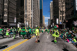
Atlanta St. Patrick's Day Parade on Peachtree Street, 2013
Peachtree is also seen in place names:
Peachtree Center is a major development of skyscrapers and other high-rises in downtown, with Peachtree Center Avenue running a block east of Peachtree Street.
West Peachtree Street is not a western branch of Peachtree Street, but a major parallel (and unlike Peachtree, almost perfectly straight) due north–south street running one block west of Peachtree Street through downtown, and mostly two or three blocks west (due to the curves in Peachtree Street) through Midtown. West Peachtree divides the northeast and northwest quadrants of the city and county for street addressing purposes.
Where the current Peachtree Street turns to Peachtree Road and briefly heads northwest, it actually crosses West Peachtree, leaving it on the "east" side. It is at this point that the Buford-Spring Connector (Georgia 13) begins, taking the route of old I-85. The studios of WSB-TV are located on this section of “West” Peachtree Street [citation needed], which terminates at I-85. The MARTARed/Gold lines run directly under West Peachtree Street. The Civic Center MARTA Station is located under West Peachtree street where the road crosses the Downtown Connector (I-75/85) The station is notable as it is among a very small number of subway stations in the world that are simultaneously above a highway and below street level.
The intersection of the two Peachtree streets in downtown form Hardy Ivy Park, while in midtown, the intersection forms Pershing Point Park.
From the Buford–Spring Connector north to Roswell Road, Peachtree Street and Peachtree Road carry U.S. Route19 (US19) and State Route9 (SR9). At a five-way intersection with East/West Paces Ferry Road at the center of the original Buckhead Village, US19 and SR9 split off onto Roswell Road, while SR141 begins on Peachtree instead. South of the connector, US19 and SR9 continue on two one-way streets: West Peachtree Street northbound and Spring Street southbound.
Peachtree meets Piedmont Road (SR237) between Buckhead Village and Lenox Square. Besides the southwestern terminus of SR13 (mentioned above) the only other major intersection in Atlanta is at North Avenue, which carries US29, US78, US278, and SR8.
Although most have been demolished, there are still several historic buildings left along Peachtree in Buckhead. Several of these are stores, in single-story brick buildings constructed well before the annexation of Buckhead in 1952.
Northeast of the city limit, the road goes through Brookhaven and passes Oglethorpe University. Upon entering Chamblee, the road splits into Peachtree Industrial Boulevard and Peachtree Road. Peachtree Road becomes a two-lane road that travels farther east towards Doraville, while Peachtree Industrial Boulevard continues more on a more northerly trajectory (as Georgia 141) towards Dunwoody and Peachtree Corners.
Atlantans are often convinced that the ridge followed by Peachtree Street is part of the Eastern Continental Divide. While Peachtree Street is atop a ridge, railroadtracks were built on the actual Eastern Continental Divide, which follows DeKalb Avenue from Decatur to Five Points, then turns southwest toward the Atlanta airport, with the northwest side draining into the Chattahoochee or Flint Rivers and therefore into the Gulf of Mexico, and the southeast side eventually into the Atlantic Ocean. In 1959, Whitehall Street SW, which meets Peachtree Street NE at Five Points, was renamed "Peachtree Street SW", and the Eastern Continental Divide follows this street, so a small portion of the story may be technically correct. Atlanta's primary water source is the Chattahoochee and much of the water is pumped over the watershed. To balance the river flows, treated sewage is pumped back to the Chattahoochee.
This page is based on this Wikipedia article Text is available under the CC BY-SA 4.0 license; additional terms may apply. Images, videos and audio are available under their respective licenses.