
AT&T Midtown Center I is a 206.4 m (677 ft), 47-story skyscraper located in Midtown Atlanta, Georgia. Completed in 1982, it serves as the regional headquarters of BellSouth Telecommunications, which does business as AT&T Southeast, and was acquired as part of AT&T's acquisition of BellSouth. BellSouth Corporate headquarters was located in the Campanile building, also in Midtown.
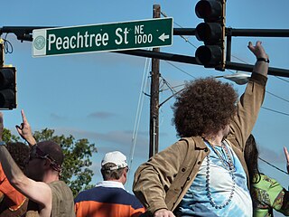
Peachtree Street is one of several major streets running through the city of Atlanta. Beginning at Five Points in downtown Atlanta, it runs North through Midtown; a few blocks after entering into Buckhead, the name changes to Peachtree Road at Deering Road. Much of the city's historic and noteworthy architecture is located along the street, and it is often used for annual parades,, as well as one-time parades celebrating events such as the 100th anniversary of Coca-Cola in 1986 and the Atlanta Braves' 1995 World Series victory.
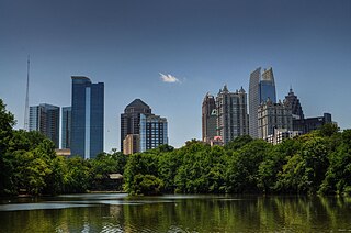
Midtown Atlanta, or Midtown, is a high-density commercial and residential neighborhood of Atlanta, Georgia. The exact geographical extent of the area is ill-defined due to differing definitions used by the city, residents, and local business groups. However, the commercial core of the area is anchored by a series of high-rise office buildings, condominiums, hotels, and high-end retail along Peachtree Street between North Avenue and 17th Street. Midtown, situated between Downtown to the south and Buckhead to the north, is the second-largest business district in Metro Atlanta. In 2011, Midtown had a resident population of 41,681 and a business population of 81,418.
From its incorporation in 1847, the municipal boundaries of Atlanta, Georgia, United States, were extended repeatedly from a small area around its railroad station to today's city covering 131.7 square miles (341 km2).

Downtown Atlanta is the central business district of Atlanta, Georgia, United States. The larger of the city's two other commercial districts, it is the location of many corporate or regional headquarters; city, county, state and federal government facilities; Georgia State University; sporting venues; and most of Atlanta's tourist attractions. It measures approximately four square miles, and had 26,700 residents as of 2010. Similar to other central business districts in the United States, it has recently undergone a transformation that included the construction of new condos and lofts, renovation of historic buildings, and arrival of new residents and businesses.

Located at 695 North Avenue in Atlanta, the Dupre Excelsior Mill, may have been built as early as 1890 by DuPre Manufacturing Company. However, the mill fails to appear on Atlanta city maps in 1892 and 1899, which both show the property as vacant. The first possible reference to the mill exist in the report of the death of Hubert Neal on July 17, 1899. According to the report, his accident occurred at the Atlanta Excelsior Works. The earliest concrete confirmation of the mill seems to be three lawsuits filed against Dupre in 1907 for accidents that occurred at the facility. The mill does appear on the Sanborn-Perris fire insurance map of 1911. At that time, the only road connecting it was Angier Street. It was noted to have been heated by steam power, no lighting, and a private water supply from a well 10 feet in diameter and 40 feet deep. A watchman made hourly rounds to seven stations.

The Great Atlanta Fire of 1917 began just after noon on 21 May 1917 in the Old Fourth Ward of Atlanta, Georgia. It is unclear just how the fire started, but it was fueled by hot temperatures and strong winds which propelled the fire. The fire, which burned for nearly 10 hours, destroyed 300 acres (120 ha) and 1,900 structures displacing over 10,000 people. Damages were estimated at $5 million,.

Clear Creek is a stream in northeast Atlanta that is a tributary to Peachtree Creek and part of the Chattahoochee River watershed. It has two main branches, one originating east of the high ground along which Boulevard runs and another to the west originating on the northeast side of downtown Atlanta. The easterly branch of Clear Creek begins in several springs and branches in what are now Inman Park and the Old Fourth Ward. Flowing north, the creek was joined by other branches and springs, including Angier Springs near the end of Belgrade Avenue and the so-called Ponce de Leon Springs, which were “discovered” during railroad construction in the 1860s and gave rise to the eponymous park and avenue.

Ponce de Leon Park ( PONSS də LEE-ən; also known as Spiller Park or Spiller Field from 1924 to 1932, and "Poncey" to locals, was the primary home field for the minor league baseball team called the Atlanta Crackers for nearly six decades. The Crackers played here in the Southern Association and the International League. It was also home of the Atlanta Black Crackers who captured the second half championship of the Negro American League in 1938.

The Old Fourth Ward, often abbreviated O4W, is an intown neighborhood on the eastside of Atlanta, Georgia, United States. The neighborhood is best known as the location of the Martin Luther King Jr. historic site.

SoNo is a sub-district of downtown Atlanta, Georgia, just south of Midtown. The area was defined and named by T. Brian Glass while working on a rezoning committee with Central Atlanta Progress in 2005 in order to better establish an identity for the area and give it a hipper image. SoNo refers to the area of Downtown bounded by North Avenue on the north, Central Park Place on the east and the Downtown Connector (Interstate-75/85) on the west and south.

Ponce de Leon Avenue, often simply called Ponce, provides a link between Atlanta, Decatur, Clarkston, and Stone Mountain, Georgia. It was named for Ponce de Leon Springs, in turn from explorer Juan Ponce de León, but is not pronounced as in Spanish. Several grand and historic buildings are located on the avenue.

South Downtown is a historic neighborhood of Downtown Atlanta, Georgia, United States. South Downtown is primarily home to city, county, state, and federal governmental offices, which prompted the city to adopt signage declaring the area "Government Walk." Although much of South Downtown is dominated by surface parking lots, the neighborhood was passed over during the redevelopment boom of the 1960s and 1970s that resulted in the demolition of much of Downtown's architecturally significant buildings. The result is myriad buildings from the 1950s and earlier that retain their historic structural integrity.

The Rufus M. Rose House is a late Victorian, Queen Anne style house located in the SoNo district of Atlanta, Georgia. Occupying a narrow lot on Peachtree Street, one and half blocks south of North Avenue, the house was built in 1901 for Dr. Rufus Mathewson Rose. The architect was Emil Charles Seiz (1873-1940), who designed many residential and commercial structures in the city, including the 1924 Massellton Apartments on Ponce de Leon Avenue.
Ponce City Market is a mixed-use development located in a former Sears catalogue facility in Atlanta, with national and local retail anchors, restaurants, a food hall, boutiques and offices, and residential units. It is located adjacent to the intersection of the BeltLine with Ponce de Leon Avenue in the Old Fourth Ward near Virginia Highland, Poncey-Highland and Midtown neighborhoods. The 2.1-million-square-foot (200,000 m2) building, one of the largest by volume in the Southeast United States, was used by Sears, Roebuck and Co. from 1926–1987 and later by the City of Atlanta as "City Hall East". The building's lot covers 16 acres (65,000 m2). Ponce City Market officially opened on August 25, 2014. It was listed on the National Register of Historic Places in 2016.

Streetcars originally operated in Atlanta downtown and into the surrounding areas from 1871 until the final line's closure in 1949.
Ponce de Leon Springs were natural springs located on the site of Ponce City Market in Atlanta, where Ponce de Leon Avenue crosses the BeltLine, and where the Old Fourth Ward, Virginia Highland, Midtown and Poncey-Highland neighborhoods of Atlanta meet.

Washington–Rawson was a neighborhood of Atlanta, Georgia. It included what is now Center Parc Stadium and the large parking lot to its north, until 1997 the site of Atlanta–Fulton County Stadium, as well as the I-20-Downtown Connector interchange. Washington and Rawson streets intersected where the interchange is today. To the northwest was Downtown Atlanta, to the west Mechanicsville, to the east Summerhill, and to the south Washington Heights, now called Peoplestown.
