Piedmont Avenue (Atlanta)

Last updated
Rucker Building, 160 Auburn Ave. at Piedmont Ave., Sweet Auburn 160 AUBURN AVENUE (Rucker Building, at corner of Auburn Ave. and Piedmont St.) EAST (PIEDMONT ST) ELEVATION - 126-255 Auburn Avenue (Commercial Buildings), Auburn Avenue, Atlanta, HABS GA,61-ATLA,1C-5.tif
Rucker Building, 160 Auburn Ave. at Piedmont Ave., Sweet Auburn
Atlanta Civic Center Atlantic Civic Center.jpg
Atlanta Civic Center
705 Piedmont Ave., Historic Midtown, listed on the National Register National Register of Historic Places, 705 Piedmont Ave. Atlanta, GA..jpg
705 Piedmont Ave., Historic Midtown, listed on the National Register
The William P. Nicolson House Shellmont Inn at 821 Piedmont Ave., Historic Midtown The William P. Nicolson House at 821 Piedmont Ave. in Atlanta, Georgia.jpg
The William P. Nicolson House Shellmont Inn at 821 Piedmont Ave., Historic Midtown
Piedmont Park Midtown HDR Atlanta.jpg
Piedmont Park

Piedmont Avenue is a major thoroughfare in Atlanta, [1] beginning in Downtown Atlanta and ending at its continuation as Piedmont Road (Georgia State Route 237) just before crossing under Interstate 85. Along the way, Piedmont Avenue passes through Midtown Atlanta where several historic properties are located on the street.

Contents

History

Piedmont Avenue was originally called Calhoun Street. As of 1872, Calhoun Street reached north to Seventh Street in today's Midtown. For the 1895 Cotton States Expo, in order to connect downtown to the exposition grounds at Piedmont Park, Plaster's Bridge Road south of 10th street was rerouted to connect to an extension of Calhoun Street, and all of this new through street was renamed Piedmont Avenue. [2]

Route

Downtown, SoNo and Old Fourth Ward

Piedmont Avenue Southeast begins at the Georgia State Capitol in Downtown Atlanta at Martin Luther King, Jr. Drive. It proceeds (one-way northbound) northeast, crossing under the Metropolitan Atlanta Rapid Transit Authority (MARTA) line at Georgia State station. It passes various Georgia State University buildings.

After crossing Edgewood Avenue, the street turns due north and becomes Piedmont Avenue Northeast, then passes Auburn Avenue, the historic heart of the black community. It then crosses the Downtown Connector freeway. At this point Piedmont Avenue forms the border between the SoNo neighborhood on the west and Old Fourth Ward on the east. In this section, Piedmont passes the Georgia Power headquarters, Renaissance Park, many gated apartment communities and several newer high-rise residential buildings, and the Atlanta Civic Center, former site of the Buttermilk Bottom slum.

Midtown

Passing North Avenue and Ponce de Leon Avenue, Piedmont enters Midtown Atlanta, first through the NRHP-listed Historic Midtown, known for its bungalow houses. In Historic Midtown there are several historic properties of note, including the Craigie House, 705 Piedmont and the William P. Nicolson House (now the Shellmont Inn) at 821 Piedmont Ave.

Piedmont and Tenth is considered the heart of the gay community in Atlanta, with several popular gay bars located here. [3] North of 10th, the streetscape turns into mostly early 20th century multi-unit residential buildings. North of 12th Street, Piedmont Avenue borders Piedmont Park, to its east.

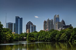
Ansley Park and Piedmont Park

After 14th Street, Piedmont Avenue becomes two-way (southbound traffic is forced to turn west on 14th Street). North of 14th, Piedmont forms the border between the posh, historic Ansley Park neighborhood on the west and Piedmont Park, the Piedmont Driving Club and the Atlanta Botanical Garden on the east. Then Piedmont crosses the BeltLine trail and Clear Creek at the northern tip of Piedmont Park and intersects with Monroe Drive, at the northwest corner of which the open-air Ansley Mall is located.

Piedmont Heights and Morningside/Lenox Park

After the intersection with Monroe, Piedmont Avenue forms the border between Piedmont Heights and Morningside/Lenox Park where the NRHP-listed Rock Spring Presbyterian Church is located. It intersects Cheshire Bridge Road and then changes its name to Piedmont Road and becomes Georgia 237, continuing north to Buckhead; at Roswell Road Piedmont Road becomes Blackland Road NW.

Related Research Articles

In Downtown Atlanta, the Downtown Connector or 75/85 is the concurrent section of Interstate 75 and Interstate 85 through the core of the city. Beginning at the I-85/Langford Parkway interchange, the Downtown Connector runs generally due north, meeting the west–east I-20 in the middle. Just north of this is the Grady Curve around Grady Memorial Hospital. Continuing north, the terminus of the Downtown Connector is the Brookwood Interchange or Brookwood Split in the Brookwood area of the city. The overall length of the Downtown Connector is approximately 7.5 miles (12 km). Since the 2000s, it has been officially named James Wendell George Parkway for most of its length, although it is still designated the Connector in the mainstream. It also has unsigned designations State Route 401 (I-75) and State Route 403 (I-85) along its length, due to I-75 and I-85 having 400-series reference numbers.

<span class="mw-page-title-main">Piedmont Park</span> Urban park in Atlanta, Georgia

Piedmont Park is an urban park in Atlanta, Georgia, located about 1 mile (1.6 km) northeast of Downtown, between the Midtown and Virginia Highland neighborhoods. Originally the land was owned by Dr. Benjamin Walker, who used it as his out-of-town gentleman's farm and residence. He sold the land in 1887 to the Gentlemen's Driving Club, who wanted to establish an exclusive club and racing ground for horse enthusiasts. The Driving Club entered an agreement with the Piedmont Exposition Company, headed by prominent Atlantan Charles A. Collier, to use the land for fairs and expositions and later gave the park its name.

<span class="mw-page-title-main">Peachtree Street</span> Main street of Atlanta, Georgia, USA

Peachtree Street is one of several major streets running through the city of Atlanta, Georgia, United States. Beginning at Five Points in downtown Atlanta, it runs North through Midtown; a few blocks after entering into Buckhead, the name changes to Peachtree Road at Deering Road. Much of the city's historic and noteworthy architecture is located along the street, and it is often used for annual parades,, as well as one-time parades celebrating events such as the 100th anniversary of Coca-Cola in 1986 and the Atlanta Braves' 1995 and 2021 World Series victories.

<span class="mw-page-title-main">Midtown Atlanta</span> Neighborhood in Fulton County, Georgia, United States

Midtown Atlanta, or Midtown, is a high-density commercial and residential neighborhood of Atlanta, Georgia. The exact geographical extent of the area is ill-defined due to differing definitions used by the city, residents, and local business groups. However, the commercial core of the area is anchored by a series of high-rise office buildings, condominiums, hotels, and high-end retail along Peachtree Street between North Avenue and 17th Street. Midtown, situated between Downtown to the south and Buckhead to the north, is the second-largest business district in Metro Atlanta. In 2011, Midtown had a resident population of 41,681 and a business population of 81,418.

<span class="mw-page-title-main">U.S. Route 123</span> Highway in the United States

U.S. Route 123 is a spur of US 23 in the U.S. states of Georgia and South Carolina. The U.S. Highway runs 75.12 miles (120.89 km) from US 23, US 441, SR 15 and SR 365 near Clarkesville, Georgia, north and east to Interstate 385 Business in Greenville, South Carolina. US 123 parallels I-85 to the north as it connects the Northeast Georgia cities of Clarkesville and Toccoa with the western Upstate South Carolina communities of Westminster, Seneca, Clemson, Easley, and Greenville.

<span class="mw-page-title-main">Home Park, Atlanta</span> Neighborhood of Atlanta, Georgia, US

Home Park is a neighborhood of Atlanta in Georgia, US. It is bordered on the south by Georgia Tech, on the west by the railroad yards adjacent to Marietta Street and Brady Avenue, on the north by 16th Street at Atlantic Station, and on the east by Techwood Drive at I-75/85.

<span class="mw-page-title-main">Georgia State Route 10</span> State highway in central Georgia

State Route 10 (SR 10) is a 172.3-mile-long (277.3 km) state highway in the U.S. state of Georgia. It travels from Downtown Atlanta to the South Carolina state line in Augusta. This highway, along with U.S. Route 78 (US 78), connect three of the biggest metro areas of the state together: Atlanta, Athens, and Augusta. It travels concurrently with US 78 in three sections: from Atlanta to Druid Hills; from near Stone Mountain to near Athens; and from Athens to its eastern terminus, for a total of 149.2 miles (240.1 km), or approximately 86.6 percent of its route.

<span class="mw-page-title-main">Ansley Park</span> United States historic place

Ansley Park is an intown residential district in Atlanta, Georgia, located just east of Midtown and west of Piedmont Park. When developed in 1905-1908, it was the first Atlanta suburban neighborhood designed for automobiles, featuring wide, winding roads rather than the grid pattern typical of older streetcar suburbs. Streets were planned like parkways with extensive landscaping, while Winn Park and McClatchey Park are themselves long and narrow, extending deep into the neighborhood.

<span class="mw-page-title-main">Arts Center station (MARTA)</span> MARTA rail station

Arts Center station is a train station in Atlanta, Georgia, serving the Red and Gold lines of the Metropolitan Atlanta Rapid Transit Authority (MARTA) rail system. It is the northernmost of three MARTA stations that serve Midtown Atlanta, the others being Midtown and North Avenue.

<span class="mw-page-title-main">Midtown station (MARTA)</span> MARTA rail station

Midtown is an underground metro station in Atlanta, Georgia, serving the Red and Gold lines of the Metropolitan Atlanta Rapid Transit Authority (MARTA) rail system. Located in Midtown Atlanta, 5,644 daily fares were collected at the gates as of 2013.

<span class="mw-page-title-main">Interstate 75 in Georgia</span> Highway in Georgia

Interstate 75 (I-75) in the US state of Georgia travels north–south along the U.S. Route 41 (US 41) corridor in the central part of the state, traveling through the cities of Valdosta, Macon, and Atlanta. It is also designated—but not signed—as State Route 401 (SR 401).

<span class="mw-page-title-main">Clear Creek (Atlanta)</span>

Clear Creek is a stream in northeast Atlanta that is a tributary to Peachtree Creek and part of the Chattahoochee River watershed. It has two main branches, one originating east of the high ground along which Boulevard runs and another to the west originating on the northeast side of downtown Atlanta. The easterly branch of Clear Creek begins in several springs and branches in what are now Inman Park and the Old Fourth Ward. Flowing north, the creek was joined by other branches and springs, including Angier Springs near the end of Belgrade Avenue and the so-called Ponce de Leon Springs, which were “discovered” during railroad construction in the 1860s and gave rise to the eponymous park and avenue.

<span class="mw-page-title-main">Ponce de Leon Avenue</span> Road in Georgia, USA

Ponce de Leon Avenue, often simply called Ponce, provides a link between Atlanta, Decatur, Clarkston, and Stone Mountain, Georgia. It was named for Ponce de Leon Springs, in turn from explorer Juan Ponce de León, but is not pronounced as in Spanish. Several grand and historic buildings are located on the avenue.

<span class="mw-page-title-main">Morningside/Lenox Park</span>

Morningside/Lenox Park is an intown neighborhood in Atlanta, Georgia founded in 1923. It is located north of Virginia-Highland, east of Ansley Park and west of Druid Hills. Approximately 3,500 households comprise the neighborhood that includes the original subdivisions of Morningside, Lenox Park, University Park, Noble Park, Johnson Estates and Hylan Park.

<span class="mw-page-title-main">U.S. Route 78 in Georgia</span> Highway in Georgia, United States

U.S. Route 78 (US 78) is a 233.3-mile-long (375.5 km) U.S. Highway in the U.S. state of Georgia. It travels west to east in the north-central part of the state, starting at the Alabama state line, west of Tallapoosa, where the roadway continues concurrent with the unsigned highway Alabama State Route 4. This is also the western terminus of Georgia State Route 8 (SR 8), which is concurrent with US 78 to the east. The highway serves the Atlanta, Athens, and Augusta metropolitan areas on its path from the Alabama state line to the South Carolina state line, at the Savannah River, on the northeastern edge of Augusta, where it continues concurrent with US 1/US 25/US 278/SC 121. This is also the eastern terminus of SR 10. US 78 travels through portions of Haralson, Carroll, Douglas, Cobb, Fulton, DeKalb, Gwinnett, Walton, Oconee, Clarke, Oglethorpe, Wilkes, McDuffie, Columbia, and Richmond counties.

<span class="mw-page-title-main">Streetcars in Atlanta</span> Aspect of the history of Atlanta, Georgia, USA

Streetcars originally operated in Atlanta downtown and into the surrounding areas from 1871 until the final line's closure in 1949.

<span class="mw-page-title-main">Washington–Rawson</span>

Washington–Rawson was a neighborhood of Atlanta, Georgia. It included what is now Center Parc Stadium and the large parking lot to its north, until 1997 the site of Atlanta–Fulton County Stadium, as well as the I-20-Downtown Connector interchange. Washington and Rawson streets intersected where the interchange is today. To the northwest was Downtown Atlanta, to the west Mechanicsville, to the east Summerhill, and to the south Washington Heights, now called Peoplestown.

<span class="mw-page-title-main">Walter T. Downing</span> American architect

Walter T. Downing (1865-1918) was an American architect in Atlanta, Georgia. Several of his works are listed on the National Register of Historic Places.

Tenth Street is a street in Midtown Atlanta, Georgia.

References