
Gwinnett County is located in the north central portion of the U.S. state of Georgia. It forms part of the Atlanta metropolitan area, being located about 9 miles (14 km) northeast of Atlanta city limits. In 2020, the population was 957,062, making it the second-most populous county in Georgia. Its county seat is Lawrenceville. The county is named for Button Gwinnett, one of the signatories of the Declaration of Independence.

Duluth is a city in Gwinnett County, Georgia, United States. Located north of Interstate 85, it is approximately 30 miles (48 km) northeast of Atlanta.

The Creek War was a regional conflict between opposing Native American factions, European powers, and the United States during the early 19th century. The Creek War began as a conflict within the tribes of the Muscogee, but the United States quickly became involved. British traders and Spanish colonial officials in Florida supplied the Red Sticks with weapons and equipment due to their shared interest in preventing the expansion of the United States into regions under their control.
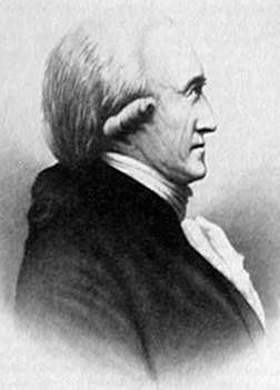
Benjamin Hawkins was an American planter, statesman and a U.S. Indian agent. He was a delegate to the Continental Congress and a United States Senator from North Carolina, having grown up among the planter elite. Appointed by George Washington in 1796 as one of three commissioners to the Creeks, in 1801 President Jefferson named him "principal agent for Indian affairs south of the Ohio [River]", and was principal Indian agent to the Creek Indians.
Peachtree Street is one of several major streets running through the city of Atlanta, Georgia, United States. Beginning at Five Points in downtown Atlanta, it runs North through Midtown; a few blocks after entering into Buckhead, the name changes to Peachtree Road at Palisades Road. Much of the city's historic and noteworthy architecture is located along the street, and it is often used for annual parades,, as well as one-time parades celebrating events such as the 100th anniversary of Coca-Cola in 1986 and the Atlanta Braves' 1995 and 2021 World Series victories.

Ocmulgee Mounds National Historical Park in Macon, Georgia, United States preserves traces of over ten millennia of culture from the Indigenous peoples of the Southeastern Woodlands. Its chief remains are major earthworks built before 1000 CE by the South Appalachian Mississippian culture These include the Great Temple and other ceremonial mounds, a burial mound, and defensive trenches. They represented highly skilled engineering techniques and soil knowledge, and the organization of many laborers. The site has evidence of "12,000 years of continuous human habitation." The 3,336-acre (13.50 km2) park is located on the east bank of the Ocmulgee River. Macon, Georgia developed around the site after the United States built Fort Benjamin Hawkins nearby in 1806 to support trading with Native Americans.

Fort Hawkins was a fort built between 1806 and 1810 by the United States Army during President Thomas Jefferson's administration. Built in what is now Georgia on the Fall Line on the east side of the Ocmulgee River, the fort overlooked the Ocmulgee Old Fields. The Lower Creek Trading Path passed by just outside the fort's northwestern blockhouse, and continued in a westerly direction to a natural ford on the Ocmulgee River. The fort became important to the Lower Creek Indians, the United States, and the State of Georgia for economic, military, and political reasons.
Red Sticks —the name deriving from the red-painted war clubs of some Native American Creek—refers to an early 19th century traditionalist faction of Muscogee Creek people in the Southeastern United States. Made up mostly of Creek of the Upper Towns that supported traditional leadership and culture, as well as the preservation of communal land for cultivation and hunting, the Red Sticks arose at a time of increasing pressure on Creek territory by European American settlers. Creek of the Lower Towns were closer to the settlers, had more mixed-race families, and had already been forced to make land cessions to the Americans. In this context, the Red Sticks led a resistance movement against European American encroachment and assimilation, tensions that culminated in the outbreak of the Creek War in 1813. Initially a civil war among the Creek, the conflict drew in United States state forces while the nation was already engaged in the War of 1812 against the British.
Standing Peachtree was a Muscogee village and the closest Indian settlement to what is now the Buckhead area of Atlanta, Georgia. It was located where Peachtree Creek flows into the Chattahoochee River, in today's Paces neighborhood. It was located in the borderlands of the Cherokee and Muscogee nations. It is referred to in several documents dating as far back as 1782.

Fort Stephenson was built in the early 1800s on the west side of the lower Sandusky River. It was the site in 1813 of an American victory in the Battle of Fort Stephenson during the War of 1812.

State Route 324 (SR 324) is a 9.6-mile-long (15.4 km) west-to-east state highway located in portions of Gwinnett and Barrow counties in the northeastern part of the U.S. state of Georgia. It connects Buford and Auburn. It also has an interchange with Interstate 85 (I-85). Before it was renamed, Carl Bethlehem Road was once part of SR 324.

Fort Dobbs was an 18th-century fort in the Yadkin–Pee Dee River Basin region of the Province of North Carolina, near what is now Statesville in Iredell County. Used for frontier defense during and after the French and Indian War, the fort was built to protect the American settlers of the western frontier of North Carolina, and served as a vital outpost for soldiers. Fort Dobbs' primary structure was a blockhouse with log walls, surrounded by a shallow ditch, and by 1759, a palisade. It was intended to provide protection from French-allied Native Americans such as the Shawnee raids into western North Carolina.
Allen Daniel Jr. (1772-1836) was a major general in the Georgia Militia during the War of 1812, a member of the Georgia House of Representatives and Georgia State Senate, and the namesake of Danielsville, Georgia, county seat of Madison County. Fort Daniel, built at Hog Mountain in Gwinnett County, Georgia in 1813 was named in his honor.

Fort Armstrong was a stockade fort built in present-day Cherokee County, Alabama during the Creek War. The fort was built to protect the surrounding area from attacks by Red Stick warriors but was also used as a staging area and supply depot in preparation for further military action against the Red Sticks.

Fort Glass was a stockade fort built in July 1813 in present-day Clarke County, Alabama during the Creek War.

Fort Hampton was a collection of log buildings and stables built in present-day Limestone County, Alabama, on a hill near the Elk River. It was named for Brigadier General Wade Hampton by Alexander Smyth, and once complete in the winter of 1810 both men visited the site. The fort was originally built to deter Americans from settling in Chickasaw territory, then was garrisoned during the War of 1812. Later, it was used for United States governmental functions prior to being abandoned.

Fort Hull was an earthen fort built in present-day Macon County, Alabama in 1814 during the Creek War. After the start of hostilities, the United States decided to mount an attack on Creek territory from three directions. The column advancing west from Georgia built Fort Mitchell and then clashed with the Creeks. After a pause in operations, the column from Georgia continued its march and built Fort Hull. The fort was used as a supply point and was soon abandoned after the end of the Creek War.

Fort Leslie was a stockade fort built in present-day Talladega County, Alabama, in 1813 during the Creek War. After the Creek War began, protective stockades were built by settlers and Creeks who were allied with the United States to protect themselves from hostile Creek attacks. Fort Leslie was the focal point of the Battle of Talladega but was soon abandoned after the end of the Creek War.
Fort Madison was a stockade fort built in August 1813 in present-day Clarke County, Alabama, during the Creek War, which was part of the larger War of 1812. The fort was built by the United States military in response to attacks by Creek warriors on encroaching American settlers. The fort shared many similarities to surrounding stockade forts in its construction but possessed a number of differences in its defenses. The fort housed members of the United States Army and settlers from the surrounding area, and it was used as a staging area for raids on Creek forces and supply point on further military expeditions. Fort Madison was subsequently abandoned at the conclusion of the Creek War and only a historical marker exists at the site today.
Fort Pierce, was two separate stockade forts built in 1813 in present-day Baldwin County, Alabama, during the Creek War, which was part of the larger War of 1812. The fort was originally built by settlers in the Mississippi Territory to protect themselves from attacks by Creek warriors. A new fort of the same name was then built by the United States military in preparation for further action in the War of 1812, but the fort was essentially abandoned within a few years. Nothing exists at the site today.


