Panthersville, Georgia

Last updated

Panthersville, Georgia
Barack H. Obama Elementary Magnet School of Technology, Panthersville, GA.jpg
The Barack H. Obama Elementary Magnet School of Technology in Panthersville
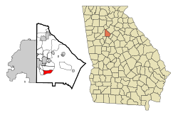
DeKalb County Georgia Incorporated and Unincorporated areas Panthersville Highlighted.svg
Location in DeKalb County and the state of Georgia
Metro atlanta.jpg
Red pog.svg
Panthersville
location in Metro Atlanta
Coordinates: 33°42′20″N84°16′43″W / 33.70556°N 84.27861°W / 33.70556; -84.27861
Country United States
State Georgia
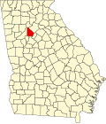
County DeKalb
Area
[1]
  Total3.69 sq mi (9.55 km2)
  Land3.67 sq mi (9.50 km2)
  Water0.02 sq mi (0.05 km2)
Elevation
889 ft (271 m)
Population
 (2020)
  Total11,237
  Density3,064.36/sq mi (1,183.14/km2)
Time zone UTC-5 (Eastern (EST))
  Summer (DST) UTC-4 (EDT)
FIPS code 13-59080 [2]
GNIS feature ID0332600 [3]
CDPs bordering eastern Atlanta CDPs bordering eastern Atlanta and Decatur.jpg
CDPs bordering eastern Atlanta

Panthersville is an unincorporated community and census-designated place (CDP) in DeKalb County, Georgia, United States. The population was 11,237 in 2020, up from 9,749 in 2010.

Contents

History

The community most likely was named after a Cherokee Indian subtribe. [4]

Geography

Panthersville is located at 33°42′20″N84°16′43″W / 33.70556°N 84.27861°W / 33.70556; -84.27861 (33.705639, -84.278551). [5] The Candler-McAfee CDP is to the north and Gresham Park CDP is to the west.

According to the United States Census Bureau, the CDP has a total area of 3.7 square miles (9.6 km2), of which 0.27% is water.

Demographics

Panthersville, Georgia – Racial and ethnic composition
Note: the US Census treats Hispanic/Latino as an ethnic category. This table excludes Latinos from the racial categories and assigns them to a separate category. Hispanics/Latinos may be of any race.
Race / Ethnicity (NH = Non-Hispanic)Pop 2000 [6] Pop 2010 [7] Pop 2020 [8] % 2000% 2010% 2020
White alone (NH)2151483591.82%1.52%3.19%
Black or African American alone (NH)11,2759,35710,19795.62%95.98%90.74%
Native American or Alaska Native alone (NH)1510210.13%0.10%0.19%
Asian alone (NH)2425570.20%0.26%0.51%
Pacific Islander alone (NH)6140.05%0.01%0.04%
Some Other Race alone (NH)1011400.08%0.11%0.36%
Mixed race or Multiracial (NH)106912540.90%0.93%2.26%
Hispanic or Latino (any race)1401063051.19%1.09%2.71%
Total11,7919,74911,237100.00%100.00%100.00%

Panthersville was first listed as a census designated place in the 1980 U.S. census. [9] [10] As of the 2020 United States census, there were 11,237 people, 4,036 households, and 2,251 families residing in the CDP.

Economy

Panthersville is home to the Gallery at South DeKalb, formerly South DeKalb Mall, a regional shopping center with a Macy's (former Rich's) department store. The former JC Penney now houses independent stores.

The CDP is the headquarters for the Georgia Bureau of Investigation, [11] and for Georgia Regional Hospital state psychiatric ward. [12]

Education

The CDP is incorporated within the DeKalb County Public Schools zone: [13]

Related Research Articles

<span class="mw-page-title-main">DeKalb County, Georgia</span> County in Georgia, United states

DeKalb County is located in the north central portion of the U.S. state of Georgia. As of the 2020 census, the population was 764,382, making it Georgia's fourth-most populous county. Its county seat is Decatur.

<span class="mw-page-title-main">Kendall West, Florida</span> Census-designated place in Florida

Kendall West is a census-designated place and unincorporated community in Miami-Dade County, Florida, west of the Florida Turnpike. It is located in the Miami metropolitan area of South Florida. The population was 36,536 at the 2020 census.

<span class="mw-page-title-main">Bonanza, Georgia</span> Place in Georgia, United States

Bonanza is an unincorporated community and census-designated place (CDP) in Clayton County, Georgia, United States. The population was 3,135 at the 2010 census, and 4,406 in 2020.

<span class="mw-page-title-main">Conley, Georgia</span> Place in Georgia, United States

Conley is an unincorporated community and census-designated place (CDP) in Clayton County, Georgia, United States. It is at Atlanta's southeast corner, 7.98 miles from downtown. The population was 6,680 at the 2020 census. It is part of the Atlanta metropolitan area.

<span class="mw-page-title-main">Belvedere Park, Georgia</span> Place in Georgia, United States

Belvedere Park is an unincorporated community and census-designated place (CDP) in DeKalb County, Georgia, United States. The population was 15,113 at the 2020 census.

<span class="mw-page-title-main">Candler-McAfee, Georgia</span> Place in Georgia, United States

Candler-McAfee is an unincorporated community and census-designated place (CDP) in DeKalb County, Georgia, United States. It is located east of Atlanta approximately 10 miles (16 km) east of Downtown Atlanta and to the south of Decatur, Georgia The population was 22,468 in 2020.

<span class="mw-page-title-main">Druid Hills, Georgia</span> Neighborhood of Atlanta, Georgia, United States

Druid Hills is a community which includes both a census-designated place (CDP) in unincorporated DeKalb County, Georgia, United States, as well as a neighborhood of the city of Atlanta. The CDP's population was 14,568 at the 2010 census. The CDP formerly contained the main campus of Emory University and the Centers for Disease Control and Prevention (CDC); however, they were annexed by Atlanta in 2018. The Atlanta-city section of Druid Hills is one of Atlanta's most affluent neighborhoods with a mean household income in excess of $238,500.

<span class="mw-page-title-main">Gresham Park, Georgia</span> Place in Georgia, United States

Gresham Park is an unincorporated community and census-designated place (CDP) in DeKalb County, Georgia, United States. The population was 7,700 at the 2020 census.

<span class="mw-page-title-main">North Decatur, Georgia</span> Place in Georgia, United States

North Decatur is an unincorporated community and census-designated place (CDP) in DeKalb County, Georgia, United States. The population was 18,511 in 2020.

<span class="mw-page-title-main">North Druid Hills, Georgia</span> Place in Georgia, United States

North Druid Hills, also known as Briarcliff or Toco Hills, is an unincorporated community and census-designated place in DeKalb County, Georgia, United States. The population was 20,385 in 2020. The commercial center of the area is the Toco Hill Shopping Center, located near the intersection of North Druid Hills Road and LaVista Road.

<span class="mw-page-title-main">Redan, Georgia</span> Place in Georgia, United States

Redan is an unincorporated community and census-designated place (CDP) in DeKalb County, Georgia, United States. As of the 2020 census, the CDP had a total population of 31,749. It is a predominantly African American community in eastern DeKalb County, and is a suburb of Atlanta.

<span class="mw-page-title-main">Hilltop, Georgia</span> Place in Georgia, United States

Hilltop is an unincorporated community and census-designated place (CDP) in Pike County, Georgia, United States. The population was 401 at the 2000 census.

<span class="mw-page-title-main">Coleman, Georgia</span> Place in Georgia, United States

Coleman is a former incorporated city in Randolph County, Georgia, United States. It is listed as a census-designated place (CDP). The population was 149 at the 2000 census. The city was abolished by House Bill 1102 effective January 1, 2007, and no longer exists as a municipality.

<span class="mw-page-title-main">East Griffin, Georgia</span> Place in Georgia, United States

East Griffin is an unincorporated community and census-designated place (CDP) in Spalding County, Georgia, United States. The population was 1,635 at the 2000 census.

<span class="mw-page-title-main">Hannahs Mill, Georgia</span> Place in Georgia, United States

Hannahs Mill is an unincorporated community and census-designated place (CDP) in Upson County, Georgia, United States. The population was 3,267 at the 2000 census.

<span class="mw-page-title-main">Lincoln Park, Georgia</span> Place in Georgia, United States

Lincoln Park is an unincorporated community and census-designated place (CDP) in Upson County, Georgia, United States. The population was 1,122 at the 2000 census.

<span class="mw-page-title-main">West Laurel, Maryland</span> Census-designated place in Maryland

West Laurel is an unincorporated area and census-designated place (CDP) in Prince George's County, Maryland, United States. Per the 2020 census, the population was 4,428.

<span class="mw-page-title-main">Kirby, Arkansas</span> Census-designated place in Arkansas, United States

Kirby is an unincorporated census-designated place in northern Pike County, Arkansas, United States. The community lies on U.S. Route 70; it is located halfway between Daisy and Glenwood. Per the 2020 census, the population was 721.

<span class="mw-page-title-main">Pastoria, Virginia</span> Census-designated place in Virginia, United States

Pastoria is a census-designated place (CDP) in Accomack County, Virginia, United States. It was first listed as a CDP in 2010. Per the 2020 census, the population was 627.

<span class="mw-page-title-main">Lost Bridge Village, Arkansas</span> Census-designated place in Arkansas, United States

Lost Bridge Village is a residential subdivision near the town of Garfield in Benton County, Arkansas, United States. Per the 2020 census, the population was 397. It is located in the Northwest Arkansas region.

References

  1. "2020 U.S. Gazetteer Files". United States Census Bureau. Retrieved December 18, 2021.
  2. "U.S. Census website". United States Census Bureau . Retrieved January 31, 2008.
  3. "US Board on Geographic Names". United States Geological Survey. October 25, 2007. Retrieved January 31, 2008.
  4. Krakow, Kenneth K. (1975). Georgia Place-Names: Their History and Origins (PDF). Macon, GA: Winship Press. p. 171. ISBN   0-915430-00-2.
  5. "US Gazetteer files: 2010, 2000, and 1990". United States Census Bureau. February 12, 2011. Retrieved April 23, 2011.
  6. "P004 Hispanic or Latino, and Not Hispanic or Latino by Race – 2000: DEC Summary File 1 – Panthersville CDP, Georgia". United States Census Bureau.
  7. "P2: Hispanic or Latino, and Not Hispanic or Latino by Race – 2010: DEC Redistricting Data (PL 94-171) – Panthersville CDP, Georgia". United States Census Bureau.
  8. "P2: Hispanic or Latino, and Not Hispanic or Latino by Race – 2020: DEC Redistricting Data (PL 94-171) – Panthersville CDP, Georgia". United States Census Bureau.
  9. "1980 Census of Population - Number of Inhabitants - Georgia" (PDF). United States Census Bureau. 1980.
  10. "1970 Census of Population - Population of County Subdivisions - Georgia" (PDF). United States Census Bureau. 1970.
  11. "Contact Us | Georgia Bureau of Investigation".
  12. "Georgia Regional Hospital, Decatur, eventseeker".
  13. "2010 CENSUS - CENSUS BLOCK MAP: Panthersville CDP, GA" (PDF). U.S. Census Bureau . Retrieved May 7, 2020. - Compare with school addresses and boundary maps.
  14. "Elementary School Attendance Areas 2016 - 2017 School Year." DeKalb County School System. Retrieved on June 1, 2017.
  15. "Middle School Attendance Areas 2016 - 2017 School Year." DeKalb County School System. Retrieved on June 1, 2017.
  16. "High School Attendance Areas 2016 - 2017 School Year." DeKalb County School System. Retrieved on June 1, 2017.