Ringgold, Georgia | |
|---|---|
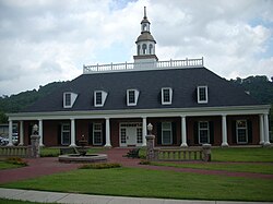 Ringgold City Hall | |
 Seal | |
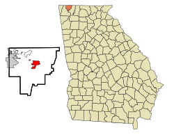 Location in Catoosa County and the state of Georgia | |
| Coordinates: 34°55′2″N85°6′57″W / 34.91722°N 85.11583°W | |
| Country | United States |
| State | Georgia |
| County | Catoosa |
| Founded | 1846 |
| Incorporated (city) | 1847 |
| Named after | Samuel Ringgold |
| Government | |
| • Mayor | Nick Millwood |
| Area | |
• Total | 5.02 sq mi (12.99 km2) |
| • Land | 5.02 sq mi (12.99 km2) |
| • Water | 0.00 sq mi (0.00 km2) |
| Elevation | 778 ft (237 m) |
| Population (2020) | |
• Total | 3,414 |
| • Density | 680.49/sq mi (262.76/km2) |
| Time zone | UTC-5 (Eastern (EST)) |
| • Summer (DST) | UTC-4 (EDT) |
| ZIP code | 30736 |
| Area codes | 706/762 |
| FIPS code | 13-65324 [2] |
| GNIS feature ID | 0329441 [3] |
| Website | cityofringgoldga.go |
Ringgold is a city in and the county seat of Catoosa County, Georgia, United States. [4] Its population was 3,414 at the 2020 census. [5] It is part of the Chattanooga metropolitan area.


