Louisville, Georgia

Last updated

Louisville, Georgia
Jefferson County Courthouse 4.JPG
Jefferson County Courthouse
Motto: 
"A Capital Community"
Jefferson County Georgia Incorporated and Unincorporated areas Louisville Highlighted.svg
Location in Jefferson County and the state of Georgia
Usa edcp relief location map.png
Red pog.svg
Louisville
Location of Louisville in the US
Coordinates: 33°0′15″N82°24′17″W / 33.00417°N 82.40472°W / 33.00417; -82.40472
Country Flag of the United States.svg  United States
State Flag of Georgia (U.S. state).svg Georgia
County Jefferson
Incorporated January 26, 1786;238 years ago (1786-01-26) [1]
Named for Louis XVI
Government
[2]
  Type Mayor–Council
   Mayor Jenny Smith[ verification needed ]
   Council
Members
  • Michelle Reaves
  • Matthew Hodges – Mayor Pro-Tem
  • Larry Atkins
  • Phil Polhill
  • Robert Dixon
Area
[3]
  Total3.68 sq mi (9.53 km2)
  Land3.61 sq mi (9.35 km2)
  Water0.07 sq mi (0.17 km2)
Elevation
322 ft (98 m)
Population
 (2020)
  Total2,381
  Density659.37/sq mi (254.57/km2)
Time zone UTC-5 (Eastern (EST))
  Summer (DST) UTC-4 (EDT)
ZIP code(s)
30434
Area code(s) 478
FIPS code 13-47560 [4]
GNIS feature ID0332271 [5]
Major airport AGS
Website cityoflouisvillegeorgia.com

Louisville is a city in and the county seat of Jefferson County, Georgia, United States, [6] and also a former state capital of Georgia. It is located southwest of Augusta on the Ogeechee River, and its population was 2,493 at the 2010 census, [7] down from 2,712 at the 2000 census. By 2020, its population was 2,381. Its name is pronounced "Lewis-ville", though it and the differently pronounced city in Kentucky were both named for Louis XVI. [8]

Contents

History

Old Market, 1934 Slave Market, Public Square, Louisville (Jefferson County, Georgia).jpg
Old Market, 1934

Louisville was incorporated on January 26, 1786, as the prospective state capital, though it did not become so for a decade. Savannah had served as the colonial capital, but was considered too far from the center of population in the growing state, and Augusta became the state capital in the 1780s.

Louisville was named for Louis XVI, who had aided the Continentals during the American Revolutionary War and was still the King of France when the decision to incorporate the city was made. Development of the city took years, and its state government buildings were completed in 1795. An old Revolutionary War soldiers' cemetery is located on the western side of town.

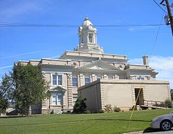
The city of Louisville served as the state capital of Georgia from 1796 to 1806. It was a center of trade, legislators, and political influence. The Jefferson County courthouse, built in 1904, stands on the site of Georgia's first permanent capitol building. [9]

Louisville's historic open-sided market house, Old Market, (Old Slave Market) still stands in the center of downtown. The original market had sections for sales of farm produce, household goods, and enslaved African Americans. The caption of a 1934 photograph in the Library of Congress proves the sale of enslaved Black people happened at this market, with details. [10] The Old Market is listed on the National Register of Historic Places. Roads and other transportation routes intersected at the market square, the hub of the region when the town was the state capital. The state capital was moved to Milledgeville and later to Atlanta, in the Piedmont.

As a small city and county seat, Louisville now has few major businesses and industries. A marker dedicated to the Yazoo land scandal of the 18th century is located in front of the Jefferson County Courthouse. Queensborough National Bank and Trust Company was founded in 1902 and is currently headquartered in Louisville, on U.S. Highway 1.

Geography

Louisville is located slightly south of the center of Jefferson County. [11] U.S. Route 1 passes through the east side of the city, leading northeast 46 miles (74 km) to Augusta and south 30 miles (48 km) to Swainsboro. U.S. Route 221 passes through the north side of downtown as Peachtree Street and leads southwest 10 miles (16 km) to Bartow. US-221 leaves Louisville to the north, running with US-1 15 miles (24 km) to Wrens before continuing north toward Harlem.

According to the United States Census Bureau, Louisville has a total area of 3.7 square miles (9.5 km2), of which 3.6 square miles (9.3 km2) are land and 0.1 square miles (0.2 km2), or 1.93%, are water. [7] The western city boundary follows Rocky Comfort Creek, which flows into the Ogeechee River at the city limits' southwest corner. The Ogeechee flows to the Atlantic Ocean south of Savannah.

Demographics

Historical population
CensusPop.Note
1810 524
1820 69432.4%
1870 356
1880 57561.5%
1890 83645.4%
1900 1,00920.7%
1910 1,0393.0%
1920 1,0400.1%
1930 1,65058.7%
1940 1,8039.3%
1950 2,23123.7%
1960 2,4138.2%
1970 2,69111.5%
1980 2,8234.9%
1990 2,429−14.0%
2000 2,71211.7%
2010 2,493−8.1%
2020 2,381−4.5%
U.S. Decennial Census [12]
Louisville racial composition as of 2020 [13]
RaceNum.Perc.
White (non-Hispanic)63326.59%
Black or African American (non-Hispanic)1,61567.83%
Native American 10.04%
Asian 251.05%
Other/Mixed 532.23%
Hispanic or Latino 542.27%

As of the 2020 United States census, there were 2,381 people, 897 households, and 606 families residing in the city.

Education

Jefferson County School District

The Jefferson County School District holds pre-school to grade twelve, and consists of two elementary schools, two middle schools, a high school, and an academy school. [14] The district has 199 full-time teachers and over 3,526 students. [15]

Private education

See also

Related Research Articles

<span class="mw-page-title-main">Washington County, Georgia</span> County in Georgia, United States

Washington County is a county located in the U.S. state of Georgia. As of the 2020 census, the population was 19,988. The county seat is Sandersville. The county was established on February 25, 1784. It was named for Revolutionary War general George Washington.

<span class="mw-page-title-main">Warren County, Georgia</span> County in Georgia, United States

Warren County is a county located in the U.S. state of Georgia. As of the 2020 United States census, the population was 5,215, a decrease from 2010. The county seat is Warrenton. The county was created on December 19, 1793, and is named after General Joseph Warren, who was killed in the Battle of Bunker Hill.

<span class="mw-page-title-main">Richmond County, Georgia</span> Consolidated city-county in Georgia, United States

Richmond County is located in the state of Georgia in the U.S. As of the 2020 census, the population was 206,607. It is one of the original counties of Georgia, created on February 5, 1777. Following an election in 1995, Augusta consolidated governments with Richmond County. The consolidated entity is known as Augusta-Richmond County, or simply Augusta. Exempt are the cities of Hephzibah and Blythe, in southern Richmond County, which voted to remain separate. Richmond County is included in the Augusta-Richmond County, GA-SCmetropolitan statistical area.

<span class="mw-page-title-main">Liberty County, Georgia</span> County in Georgia, United States

Liberty County is a county in the U.S. state of Georgia. As of the 2020 census, the population is 65,256. The county seat is Hinesville.

<span class="mw-page-title-main">Jefferson County, Georgia</span> County in Georgia, United States

Jefferson County is a county located in the U.S. state of Georgia. As of the 2020 census, the population was 15,709. The county seat and largest city is Louisville. The county was created on February 20, 1796, and named for Thomas Jefferson, the main author of the Declaration of Independence who became the third president of the United States.

<span class="mw-page-title-main">Glascock County, Georgia</span> County in Georgia, United States

Glascock County is a county located in the U.S. state of Georgia. As of the 2020 census, the population was 2,884, making it the fourth-least populous county in Georgia. The county seat is Gibson. The county was created on December 19, 1857.

<span class="mw-page-title-main">Effingham County, Georgia</span> County in Georgia, United States

Effingham County is a county located in the southeastern part of the U.S. state of Georgia. As of the 2020 census, the population was 64,769. The seat is Springfield.

<span class="mw-page-title-main">Columbia County, Georgia</span> County in Georgia, United States

Columbia County is a county located in the east central portion of the U.S. state of Georgia. As of the 2020 census, the population was 156,010. The legal county seat is Appling, but the de facto seat of county government is Evans.

<span class="mw-page-title-main">Chatham County, Georgia</span> County in Georgia, United States

Chatham County is located in the U.S. state of Georgia, on the state's Atlantic coast. The county seat and largest city is Savannah. One of the original counties of Georgia, Chatham County was created February 5, 1777, and is named after William Pitt, 1st Earl of Chatham.

<span class="mw-page-title-main">Bryan County, Georgia</span> County in Georgia, United States

Bryan County is a county located in the U.S. state of Georgia. As of the 2020 census, the population was 44,738. The county seat is Pembroke.

<span class="mw-page-title-main">Burke County, Georgia</span> County in Georgia, United States

Burke County is a county located along the eastern border of the U.S. state of Georgia in the Piedmont. As of the 2020 census, the population was 24,596. The county seat is Waynesboro. Burke County is part of the Augusta-Richmond County, GA-SC metropolitan statistical area.

<span class="mw-page-title-main">Richmond Hill, Georgia</span> City in Georgia, United States

Richmond Hill is a city in Bryan County, Georgia, United States. The population was 16,633 at the 2020 U.S. census, an increase of almost 80% from the 2010 population of 9,281. Richmond Hill is part of the Savannah metropolitan statistical area.

<span class="mw-page-title-main">Evans, Georgia</span> Place in Georgia, United States

Evans is an unincorporated community and census-designated place (CDP) in Columbia County, Georgia, United States. It is a suburb of Augusta and is part of the Augusta metropolitan area. The population was 29,011 at the 2010 census, up from 17,727 at the 2000 census.

<span class="mw-page-title-main">Gibson, Georgia</span> City in Georgia, United States

Gibson is a city in Glascock County, Georgia, United States. The population was 663 at the 2010 census, and 630 in 2020. The city is the county seat of Glascock County and home to the Glascock County Courthouse, a National Register of Historic Places listed site.

<span class="mw-page-title-main">Stapleton, Georgia</span> City in Georgia, United States

Stapleton is a city in Jefferson County, Georgia, United States. The population was 402 in 2020.

<span class="mw-page-title-main">Wrens, Georgia</span> City in Georgia, United States

Wrens is a city in Jefferson County, Georgia, United States. The population was 2,217 at the 2020 census. It is located on U.S. Route 1, thirty miles south of Augusta.

<span class="mw-page-title-main">Millen, Georgia</span> City in Georgia, United States

Millen is a city, and the county seat of Jenkins County, Georgia, United States. The population was 3,120 at the 2010 census, down from 3,492 at the 2000 census.

<span class="mw-page-title-main">Hinesville, Georgia</span> City in Georgia, United States

Hinesville is a city and county seat of Liberty County, Georgia, United States, located on the Atlantic coastal plain. The population was 33,437 at the 2010 census and an estimated 33,273 in 2019. By 2020, its population was 34,891. It is the principal city of the Hinesville metropolitan area, which comprises all of Liberty County, including the Fort Stewart army installation, plus neighboring Long County.

<span class="mw-page-title-main">North Augusta, South Carolina</span> City in South Carolina, United States

North Augusta is a city in Aiken and Edgefield counties in the U.S. state of South Carolina, on the north bank of the Savannah River. It lies directly across the river, and state border, from Augusta, Georgia. The population was 24,379 at the 2020 census, making it the 21st most populous city in South Carolina. The city is included in the Central Savannah River Area (CSRA) and is part of the Augusta, Georgia, metropolitan area.

<span class="mw-page-title-main">Waynesboro, Georgia</span> City in Georgia, United States

Waynesboro is a city and the county seat of Burke County, Georgia, United States. The population was 5,766 at the 2010 census. It is part of the Augusta, Georgia metropolitan area.

References

  1. Holmes, Yulssus Lynn (1996). Those Glorious Days: A History of Louisville as Georgia's Capital, 1796-1807. Macon, Georgia: Mercer University Press. p. 26. ISBN   0-86554-527-8. LCCN   96030440. OCLC   35084837. OL   992000M.
  2. "City Officials". City of Louisville, Georgia. 2017. Archived from the original on May 9, 2017. Retrieved May 17, 2017.
  3. "2020 U.S. Gazetteer Files". United States Census Bureau. Retrieved December 18, 2021.
  4. "U.S. Census website". United States Census Bureau . Retrieved January 31, 2008.
  5. "US Board on Geographic Names". United States Geological Survey. October 25, 2007. Archived from the original on February 12, 2012. Retrieved January 31, 2008.
  6. "Find a County". National Association of Counties. Archived from the original on May 31, 2011. Retrieved June 7, 2011.
  7. 1 2 "Geographic Identifiers: 2010 Census Summary File 1 (G001): Louisville city, Georgia". American Factfinder. U.S. Census Bureau. Archived from the original on February 13, 2020. Retrieved May 4, 2018.
  8. Krakow, Kenneth K. (1975). Georgia Place-Names: Their History and Origins (PDF). Macon, GA: Winship Press. p. 137. ISBN   0-915430-00-2. Archived (PDF) from the original on March 11, 2016. Retrieved March 13, 2019.
  9. Louisville Archived August 6, 2013, at the Wayback Machine , Georgia.gov, accessed August 27, 2013.
  10. "Slave Market, Public Square, Louisville, Jefferson County, GA". Library of Congress, Washington, D.C. 20540 USA. Retrieved May 18, 2022.
  11. "US Gazetteer files: 2010, 2000, and 1990". United States Census Bureau. February 12, 2011. Retrieved April 23, 2011.
  12. "Census of Population and Housing". Census.gov. Retrieved June 4, 2015.
  13. "Explore Census Data". data.census.gov. Retrieved December 15, 2021.
  14. Georgia Board of Education [ permanent dead link ], Retrieved June 20, 2010.
  15. School Stats Archived November 25, 2011, at the Wayback Machine , Retrieved June 20, 2010.

Further reading

Government
General information