Bath, South Carolina | |
|---|---|
 Bath | |
| Coordinates: 33°30′16″N81°52′08″W / 33.50444°N 81.86889°W | |
| Country | United States |
| State | South Carolina |
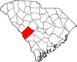
| County | Aiken |
| Population (2010) | |
• Total | 1,033 |
| Time zone | UTC-5 (Eastern (EST)) |
| • Summer (DST) | UTC-4 (EDT) |
| ZIP code | 29816 |
| Area codes | 803, 839 |
| GNIS feature ID | 1231033 [1] |
Bath is an unincorporated community in Aiken County, South Carolina, United States. The community is located in the Horse Creek Valley, and its zip code is 29816. It is part of the Augusta, Georgia metropolitan area.