
The Muscogee, also known as the Mvskoke, Muscogee Creek or just Creek, and the Muscogee Creek Confederacy, are a group of related Indigenous peoples of the Southeastern Woodlands in the United States. Their historical homelands are in what now comprises southern Tennessee, much of Alabama, western Georgia and parts of northern Florida.

The Savannah River is a major river in the Southeastern United States, forming most of the border between South Carolina and Georgia. Two tributaries of the Savannah, the Tugaloo River and the Chattooga River, form the northernmost part of the state border. The Savannah River drainage basin extends into the southeastern side of the Appalachian Mountains just inside North Carolina, bounded by the Eastern Continental Divide. The river is around 301 miles (484 km) long. The Savannah was formed by the confluence of the Tugaloo River and the Seneca River. Today this confluence is part of Lake Hartwell. The Tallulah Gorge is located on the Tallulah River, a tributary of the Tugaloo River that forms the northwest branch of the Savannah River.
The Cherokee Path was the primary route of English and Scots traders from Charleston to Columbia, South Carolina in Colonial America. It was the way they reached Cherokee towns and territories along the upper Keowee River and its tributaries. In its lower section it was known as the Savannah River. They referred to these towns along the Keowee and Tugaloo rivers as the Lower Towns, in contrast to the Middle Towns in Western North Carolina and the Overhill Towns in present-day southeastern Tennessee west of the Appalachian Mountains.

The colonial period of South Carolina saw the exploration and colonization of the region by European colonists during the early modern period, eventually resulting in the establishment of the Province of Carolina by English settlers in 1663, which was then divided to create the Province of South Carolina in 1710. European settlement in the region of modern-day South Carolina began on a large scale after 1651, when frontiersmen from the English colony of Virginia began to settle in the northern half of the region, while the southern half saw the immigration of plantation owners from Barbados, who established slave plantations which cultivated cash crops such as tobacco, cotton, rice and indigo.
The Yamasee War was a conflict fought in South Carolina from 1715 to 1717 between British settlers from the Province of Carolina and the Yamasee, who were supported by a number of allied Native American peoples, including the Muscogee, Cherokee, Catawba, Apalachee, Apalachicola, Yuchi, Savannah River Shawnee, Congaree, Waxhaw, Pee Dee, Cape Fear, Cheraw, and others. Some of the Native American groups played a minor role, while others launched attacks throughout South Carolina in an attempt to destroy the colony.
The Yamasees were a multiethnic confederation of Native Americans who lived in the coastal region of present-day northern coastal Georgia near the Savannah River and later in northeastern Florida. The Yamasees engaged in revolts and wars with other native groups and Europeans living in North America, specifically from Florida to North Carolina.
Guale was a historic Native American chiefdom of Mississippian culture peoples located along the coast of present-day Georgia and the Sea Islands. Spanish Florida established its Roman Catholic missionary system in the chiefdom in the late 16th century.
The Westo were an Iroquoian Native American tribe encountered in what became the Southeastern U.S. by Europeans in the 17th century. They probably spoke an Iroquoian language. The Spanish called these people Chichimeco, and Virginia colonists may have called the same people Richahecrian. Their first appearance in the historical record is as a powerful tribe in colonial Virginia who had migrated from the mountains into the region around present-day Richmond. Their population provided a force of 700–900 warriors.

The dead town of New Savannah began circa 1740 as a Chickasaw village on the Savannah River, at the mouth of Butler Creek below Augusta. Stories as to the circumstances vary, but in any case some portion of the Horse Creek Chickasaws under Squirrel King moved across the river and founded the town from which they farmed, hunted and scouted until the Revolutionary War. In 1757, CPT Daniel Pepper estimated the population there as "seventy Gun Men".

The Cherokee–American wars, also known as the Chickamauga Wars, were a series of raids, campaigns, ambushes, minor skirmishes, and several full-scale frontier battles in the Old Southwest from 1776 to 1794 between the Cherokee and American settlers on the frontier. Most of the events took place in the Upper South region. While the fighting stretched across the entire period, there were extended periods with little or no action.

Fort King George State Historic Site is a fort located in the U.S. state of Georgia in McIntosh County, adjacent to Darien. The fort was built in 1721 along what is now known as the Darien River and served as the southernmost outpost of the British Empire in the Americas until 1727. The fort was constructed in what was then considered part of the colony of South Carolina, but was territory later settled as Georgia. It was part of a defensive line intended to encourage settlement along the colony's southern frontier, from the Savannah River to the Altamaha River. Great Britain, France, and Spain were competing to control the American Southeast, especially the Savannah-Altamaha River region.

The Cusabo were a group of American Indian tribes who lived along the coast of the Atlantic Ocean in what is now South Carolina, approximately between present-day Charleston and south to the Savannah River, at the time of European colonization. English colonists often referred to them as one of the Settlement Indians of South Carolina, tribes who "settled" among the colonists.
Henry Woodward, was a Barbados-born merchant and colonist who was one of the first white settlers in the Carolinas. He established relationships with many Native American Tribes in the American southeast. He initiated trade, primarily in deerskins and slaves, with many Indian towns and tribes.

Slavery among Native Americans in the United States includes slavery by and enslavement of Native Americans roughly within what is currently the United States of America.
The Cherokee people of the southeastern United States, and later Oklahoma and surrounding areas, have a long military history. Since European contact, Cherokee military activity has been documented in European records. Cherokee tribes and bands had a number of conflicts during the 18th century with Europeans, primarily British colonists from the Southern Colonies. The Eastern Band and Cherokees from the Indian Territory fought in the American Civil War, with bands allying with the Union or the Confederacy. Because many Cherokees allied with the Confederacy, the United States government required a new treaty with the nation after the war. Cherokees have also served in the United States military during the 20th and 21st centuries.

Cherokee history is the written and oral lore, traditions, and historical record maintained by the living Cherokee people and their ancestors. In the 21st century, leaders of the Cherokee people define themselves as those persons enrolled in one of the three federally recognized Cherokee tribes: The Eastern Band of Cherokee Indians, The Cherokee Nation, and The United Keetoowah Band of Cherokee Indians.
George Galphin (1708–1780) was an American businessman specializing in Indian Trade, an Indian Commissioner, and plantation owner who lived and conducted business in the colonies of Georgia and South Carolina, primarily around the area known today as Augusta, Georgia.

Horse Creek Valley is a geographic area along Horse Creek, a tributary of the Savannah River. It lies within present-day Aiken County, South Carolina. The area is alternately referred to as "Midland Valley". Rising near Vaucluse, South Carolina, Horse Creek enters the Savannah two miles downstream of downtown Augusta, Georgia. Other communities along Horse Creek include Graniteville, Warrenville, Gloverville, Langley, Burnettown, Bath, and Clearwater. While Horse Creek itself is rather insignificant, its potential for water power led to early examples of Southern industrialization, including a textile mill at Vaucluse (1830) and William Gregg's Graniteville Mill (1845). The textile industry continued to play a primary role until the Graniteville Train Derailment and final closure of the Graniteville Mill in 2006.
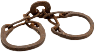
Native Americans living in the American Southeast were enslaved through warfare and purchased by European colonists in North America throughout the 17th, 18th, and 19th centuries, as well as held in captivity through Spanish-organized forced labor systems in Florida. Emerging British colonies in Virginia, Carolina, and Georgia imported Native Americans and incorporated them into chattel slavery systems, where they intermixed with slaves of African descent, who would eventually come to outnumber them. The settlers' demand for slaves affected communities as far west as present-day Illinois and the Mississippi River and as far south as the Gulf Coast. European settlers exported tens of thousands of enslaved Native Americans outside the region to New England and the Caribbean.

The Mississippian shatter zone describes the period from 1540 to 1730 in the southeastern part of the present United States. During that time, the interaction between European explorers and colonists transformed the Native American cultures of that region. In 1540 dozens of chiefdoms and several paramount chiefdoms were scattered throughout the southeast. Chiefdoms featured a noble class ruling a large number of commoners and were characterized by villages and towns with large earthen mounds and complex religious practices. Some chiefdoms, known as paramount chieftains, ruled or influenced large areas. The chiefdoms were ravaged by the de Soto and other Spanish exploratory missions in the 1540s through the 1560s and their decline began.

