Langley, South Carolina | |
|---|---|
 Langley | |
| Coordinates: 33°30′43″N81°50′04″W / 33.51194°N 81.83444°W [1] | |
| Country | United States |
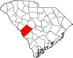
| State | South Carolina |
| County | Aiken |
| Named after | William C. Langley |
| Area | |
• Total | 1.14 sq mi (2.95 km2) |
| • Land | 1.14 sq mi (2.94 km2) |
| • Water | 0.0039 sq mi (0.01 km2) |
| Elevation | 292 ft (89 m) |
| Population | |
• Total | 1,485 |
| • Density | 1,307.6/sq mi (504.87/km2) |
| Time zone | UTC-5 (Eastern (EST)) |
| • Summer (DST) | UTC-4 (EDT) |
| ZIP code | 29834 |
| Area codes | 803 and 839 |
| FIPS code | 45-40390 [4] |
| GNIS feature ID | 2584532 [1] |
Langley is a census-designated place (CDP) in Aiken County, South Carolina, United States. The population was 1,447 at the 2010 census. [5] It is bordered by Gloverville to the northeast and Burnettown to the west.
Contents
Langley is part of the Augusta, Georgia metropolitan area. Langley is located in historic Horse Creek Valley. It sits next to the Langley pond.