Crawfordville, Georgia

Last updated

Crawfordville, Georgia
Crawfordville, Georgia downtown.jpg
Broad Street storefronts in downtown Crawfordville, Georgia, with Taliaferro County Courthouse in the distance
CrawfordvilleGAlogo.png
Taliaferro County Georgia Incorporated and Unincorporated areas Crawfordville Highlighted.svg
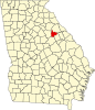
Location in Taliaferro County and the state of Georgia
Coordinates: 33°33′17″N82°53′54″W / 33.55472°N 82.89833°W / 33.55472; -82.89833
CountryUnited States
State Georgia
County Taliaferro
Government
  MayorVivian Stewart
Area
[1]
  Total
3.14 sq mi (8.12 km2)
  Land3.12 sq mi (8.07 km2)
  Water0.02 sq mi (0.05 km2)
Elevation
614 ft (187 m)
Population
 (2020)
  Total
479
  Density153.77/sq mi (59.37/km2)
Time zone UTC-5 (Eastern (EST))
  Summer (DST) UTC-4 (EDT)
ZIP code
30631
Area code 706
FIPS code 13-20316 [2]
GNIS feature ID0313097 [3]
Website crawfordvillega.org
Crawfordville Historic District
USA Georgia location map.svg
Red pog.svg
Usa edcp location map.svg
Red pog.svg
LocationRoughly centered on the downtown business district of Crawfordville, Taliaferro, Georgia
Area1,738 acres (703 ha)
Built1826
Built byCharles Golucke/Golucke & Son, Julius Kendrick, J.H. McKenzie & Son (Taliaferro County Courthouse), others
ArchitectLewis F. Goodrich (Taliaferro County Courthouse)
Architectural styleMid 19th Century Revival, Late Victorian
NRHP reference No. 06000124 [4]
Added to NRHPMarch 14, 2006

Crawfordville is a city and the county seat of Taliaferro County, Georgia, United States. [5] The population was 479 in 2020.

Contents

History

Crawfordville was founded in 1825 as the seat of the newly formed Taliaferro County. It was incorporated as a town in 1826 and as a city in 1906. [6] The community was named after William H. Crawford (1772–1834), U.S. Secretary of War and Secretary of the Treasury. [7]

Geography

Crawfordville is located at 33°33′17″N82°53′54″W / 33.55472°N 82.89833°W / 33.55472; -82.89833 (33.554626, -82.898428). [8] According to the United States Census Bureau, the city has a total area of 3.1 square miles (8.0 km2), all land.

Demographics

Historical population
CensusPop.Note
1880 511
1890 58414.3%
1900 5972.2%
1910 68815.2%
1920 78414.0%
1930 8407.1%
1940 1,05625.7%
1950 966−8.5%
1960 786−18.6%
1970 735−6.5%
1980 594−19.2%
1990 577−2.9%
2000 572−0.9%
2010 534−6.6%
2020 479−10.3%
U.S. Decennial Census [9]
Crawfordville city, Georgia – Racial and ethnic composition
Note: the US Census treats Hispanic/Latino as an ethnic category. This table excludes Latinos from the racial categories and assigns them to a separate category. Hispanics/Latinos may be of any race.
Race / Ethnicity (NH = Non-Hispanic)Pop 2010 [10] Pop 2020 [11] % 2010% 2020
White alone (NH)19216935.96%35.28%
Black or African American alone (NH)31927759.74%57.83%
Native American or Alaska Native alone (NH)100.19%0.00%
Asian alone (NH)430.75%0.63%
Pacific Islander alone (NH)000.00%0.00%
Some Other Race alone (NH)000.00%0.00%
Mixed Race or Multi-Racial (NH)10211.87%4.38%
Hispanic or Latino (any race)891.50%1.88%
Total534479100.00%100.00%

Education

Taliaferro County School District

The Taliaferro County School District consists of one charter school offering pre-school to grade twelve. [12] As of 2023, the district had 26 full-time teachers and 187 students. [13] Their Mascot is the Jaguars. [14]

Attractions

Crawfordville was the birthplace and home of Alexander H. Stephens, who served as a U.S. Congressman, Governor of Georgia, and most notably as Vice President of the Confederate States of America, 1861–1865. Stephens' home, Liberty Hall, is preserved as a museum and is a part of the A. H. Stephens Historic Park, a Georgia State Park located in Crawfordville.

Crawfordville is also the birthplace of Michael H. Rhodes, a radio and television personality that worked for Seattle based KING broadcasting during the 1940s–1980s alongside other famous Northwest greats: JP Patches and Stan Boreson.

The movie Sweet Home Alabama was partially filmed in Crawfordville. It includes the historical Taliaferro County Courthouse in one scene, as well as a scene with Reese Witherspoon walking down Main Street.

The movies Coward of the County with Kenny Rogers, Get Low with Robert Duvall, Gorp, and the 1978 TV movie Summer of My German Soldier were filmed here.

See also

References

  1. "2020 U.S. Gazetteer Files". United States Census Bureau. Retrieved December 18, 2021.
  2. "U.S. Census website". United States Census Bureau . Retrieved January 31, 2008.
  3. "US Board on Geographic Names". United States Geological Survey. October 25, 2007. Retrieved January 31, 2008.
  4. "National Register Information System". National Register of Historic Places . National Park Service. July 9, 2010.
  5. "Find a County". National Association of Counties. Archived from the original on May 31, 2011. Retrieved June 7, 2011.
  6. Hellmann, Paul T. (May 13, 2013). Historical Gazetteer of the United States. Routledge. p. 226. ISBN   978-1135948597 . Retrieved November 30, 2013.
  7. Krakow, Kenneth K. (1975). Georgia Place-Names: Their History and Origins (PDF). Macon, GA: Winship Press. p. 54. ISBN   0-915430-00-2.
  8. "US Gazetteer files: 2010, 2000, and 1990". United States Census Bureau. February 12, 2011. Retrieved April 23, 2011.
  9. "Census of Population and Housing". Census.gov. Retrieved June 4, 2015.
  10. "P2 Hispanic or Latino, and Not Hispanic or Latino by Race –– 2010: DEC Redistricting Data (PL 94-171) – Crawfordville city, Georgia". United States Census Bureau .
  11. "P2 Hispanic or Latino, and Not Hispanic or Latino by Race – 2020: DEC Redistricting Data (PL 94-171) – Crawfordville city, Georgia". United States Census Bureau .
  12. Georgia Board of Education [ permanent dead link ], Retrieved June 26, 2010.
  13. "Taliaferro County". National Center for Education Statistics. Retrieved May 25, 2024.
  14. "Parents & Students". www.taliaferro.k12.ga.us. Retrieved May 3, 2023.