Sycamore, Georgia

Last updated

Sycamore, Georgia
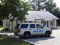
Sycamore City Hall and Police Station.JPG
Sycamore City Hall and Police Station
Turner County Georgia Incorporated and Unincorporated areas Sycamore Highlighted.svg
Location in Turner County and the state of Georgia
Coordinates: 31°40′15″N83°38′2″W / 31.67083°N 83.63389°W / 31.67083; -83.63389
Country United States
State Georgia
County Turner
Government
   Mayor Wayne Wooddruff
Area
[1]
  Total1.01 sq mi (2.63 km2)
  Land0.99 sq mi (2.57 km2)
  Water0.02 sq mi (0.06 km2)
Elevation
390 ft (119 m)
Population
 (2020)
  Total692
  Density697.58/sq mi (269.37/km2)
Time zone UTC-5 (Eastern (EST))
  Summer (DST) UTC-4 (EDT)
ZIP code
31790
Area code 229
FIPS code 13-75104 [2]
GNIS feature ID0333176 [3]
Website www.sycamorega.com

Sycamore is a city in Turner County, Georgia, United States. The population was 692 in 2020.

Contents

History

The Georgia General Assembly incorporated Sycamore as a town in 1891. [4] The community was named for the American sycamore trees near the original town site. [5]

Geography

Sycamore is located at 31°40′15″N83°38′2″W / 31.67083°N 83.63389°W / 31.67083; -83.63389 (31.670810, -83.633871). [6] According to the United States Census Bureau, the city has a total area of 1.0 square mile (2.6 km2), all land.

The climate in this area is characterized by relatively high temperatures and evenly distributed precipitation throughout the year. According to the Köppen Climate Classification system, Sycamore has a humid subtropical climate, abbreviated "Cfa" on climate maps. [7]

Demographics

Historical population
CensusPop.Note
1900 274
1910 2968.0%
1920 56289.9%
1930 559−0.5%
1940 6017.5%
1950 6243.8%
1960 501−19.7%
1970 5479.2%
1980 474−13.3%
1990 417−12.0%
2000 49618.9%
2010 71143.3%
2020 692−2.7%
U.S. Decennial Census [8]

As of the census [2] of 2010, there were 711 people, 191 households, and 131 families residing in the city. The population density was 711 inhabitants per square mile (275/km2). There were 218 housing units at an average density of 218 per square mile (84/km2). The racial makeup of the city was 61.7% White, 35.9% African American, 0.6% American Indian and Alaska Native, 1.81% from other races, and 0% from two or more races. Hispanic or Latino of any race were 2.8% of the population.

There were 191 households, out of which 29.3% had children under the age of 18 living with them, 52.9% were married couples living together, 10.5% had a female householder with no husband present, and 31.4% were non-families. 23.6% of all households were made up of individuals, and 10.8% had someone living alone who was 65 years of age or older. The average household size was 2.61 and the average family size was 3.11.

In the city, the population was spread out, with 21.2% under the age of 20, 11.4% from 10 to 24, 34.4% from 25 to 44, 22.4% from 45 to 64, and 10.5% who were 65 years of age or older. The median age was 33.3 years. For every 100 females, there were 189 males. For every 100 females age 18 and over, there were 214 males.

As of the census [2] of 2010, the median income for a household in the city was $19,063, and the median income for a family was $23,750. Males had a median income of $23,750 versus $17,143 for females. The per capita income for the city was $12,346. About 14.4% of families and 25.8% of the population were below the poverty line, including 30.3% of those under age 18 and 30.9% of those age 65 or over.

Notable people

Related Research Articles

<span class="mw-page-title-main">Pinehurst, Georgia</span> City in Georgia, United States

Pinehurst is a city in Dooly County, Georgia, United States. The population was 455 at the 2010 census, up from 307 in 2000.

<span class="mw-page-title-main">Bowman, Georgia</span> City in Georgia, United States

Bowman is a city in Elbert County, Georgia, United States. As of the 2020 census, the city had a population of 872.

<span class="mw-page-title-main">Pendergrass, Georgia</span> City in Georgia, United States

Pendergrass is a city in Jackson County, Georgia, United States. The population was 1692 at the time of the 2020 census.

<span class="mw-page-title-main">Carlton, Georgia</span> City in Georgia, United States

Carlton is a city in Madison County, Georgia, United States. The population was 263 at the 2020 census.

<span class="mw-page-title-main">Uvalda, Georgia</span> City in Georgia, United States

Uvalda is a city in Montgomery County, Georgia, United States. The population was 439 at the 2020 census, down from 598 in 2010. It is part of the Vidalia Micropolitan Statistical Area.

<span class="mw-page-title-main">Coolidge, Georgia</span> City in Georgia, United States

Coolidge is a city in Thomas County, Georgia, United States. The population was 528 in 2020.

<span class="mw-page-title-main">Sycamore, Kentucky</span> City in Kentucky, United States

Sycamore is a home rule-class city in Jefferson County, Kentucky, United States. The population was 160 at the 2010 census.

<span class="mw-page-title-main">Hartford, Maine</span> Town in the state of Maine, United States

Hartford is a town in Oxford County, Maine, United States. Hartford is included in the Lewiston-Auburn, Maine metropolitan New England City and Town Area. The population was 1,203 at the 2020 census.

Spring Creek Township is a township in Norman County, Minnesota, United States. The population was 83 at the 2000 census.

<span class="mw-page-title-main">Corning, Missouri</span> Village in Missouri, United States

Corning is a village in Holt County, Missouri, United States. The population was 3 at the 2020 census.

<span class="mw-page-title-main">Maddock, North Dakota</span> City in North Dakota, United States

Maddock is a city in Benson County, North Dakota, United States. The population was 402 at the 2020 census. Maddock was founded in 1901.

<span class="mw-page-title-main">Newburg, North Dakota</span> City in North Dakota, United States

Newburg is a city in Bottineau County, North Dakota, United States. The population was 96 at the 2020 census. Newburg was founded in 1906.

<span class="mw-page-title-main">Columbus, North Dakota</span> City in North Dakota, United States

Columbus is a city in Burke County, North Dakota, United States. The population was 139 at the 2020 census. Columbus was founded in 1906. Both this town and nearby Larson were named for an early postmaster who served the area, making it possibly the only town so named that was not named for Christopher Columbus.

<span class="mw-page-title-main">Venturia, North Dakota</span> City in North Dakota, United States

Venturia is a city in McIntosh County, North Dakota, United States. The population was 21 at the 2020 census. Venturia was founded in 1901.

<span class="mw-page-title-main">Ralston, Oklahoma</span> Town in Oklahoma, United States

Ralston is a town in Pawnee County, Oklahoma, United States. The town is southeast of Ponca City on State Highway 18 near the west bank of the Arkansas River. The population was 330 at the 2010 census, a decline of 7 percent from the figure of 355 recorded in 2000.

<span class="mw-page-title-main">Butte Falls, Oregon</span> City in Oregon, United States

Butte Falls is a city in Jackson County, Oregon, United States. The population was 423 at the 2010 census. As of July 1, 2018, the city's population was estimated to be 450.

<span class="mw-page-title-main">Dilley, Texas</span> City in Texas, United States

Dilley is a city in Frio County, Texas, United States. The population was 3,894 at the 2010 census. It is located off Interstate 35 south of the county seat in Pearsall.

<span class="mw-page-title-main">Cushing, Texas</span> City in Texas, United States

Cushing is a city in Nacogdoches County, Texas, United States. The population was 612 at the 2010 census.

<span class="mw-page-title-main">Gassaway, West Virginia</span> Town in West Virginia, United States

Gassaway is a town in Braxton County, West Virginia, United States. The population was 769 at the 2020 census. Gassaway was incorporated in 1905 and named for Henry Gassaway Davis, the Democratic Party's nominee for Vice President of the United States in 1904. The center of population of West Virginia is located approximately 7 miles (11 km) north of Gassaway.

<span class="mw-page-title-main">Iaeger, West Virginia</span> Town in West Virginia, United States

Iaeger is a town in McDowell County, West Virginia, United States. The population was 257 at the 2020 census.

References

  1. "2020 U.S. Gazetteer Files". United States Census Bureau. Retrieved December 18, 2021.
  2. 1 2 3 "U.S. Census website". United States Census Bureau . Retrieved January 31, 2008.
  3. "US Board on Geographic Names". United States Geological Survey. October 25, 2007. Retrieved January 31, 2008.
  4. Acts and Resolutions of the General Assembly of the State of Georgia. Clark & Hines, State Printers. 1892. p. 817.
  5. Krakow, Kenneth K. (1975). Georgia Place-Names: Their History and Origins (PDF). Macon, GA: Winship Press. p. 218. ISBN   0-915430-00-2.
  6. "US Gazetteer files: 2010, 2000, and 1990". United States Census Bureau. February 12, 2011. Retrieved April 23, 2011.
  7. Climate Summary for Sycamore, Georgia
  8. "Census of Population and Housing". Census.gov. Retrieved June 4, 2015.