Collier County, Florida

Last updated

Collier County
Naples, FL, Courthouse, Collier County, 04-18-2010 (1).JPG
The Collier County courthouse in April 2010
Flag of Collier County, Florida.png
Seal of Collier County, Florida.png
Logo of Collier County, Florida.png
Map of Florida highlighting Collier County.svg
Location within the U.S. state of Florida
Florida in United States.svg
Florida's location within the U.S.
Coordinates: 26°05′N81°24′W / 26.08°N 81.4°W / 26.08; -81.4
CountryFlag of the United States.svg United States
StateFlag of Florida.svg  Florida
FoundedMay 8, 1923
Named for Barron Collier
Seat East Naples
Largest city Naples
Area
  Total2,305 sq mi (5,970 km2)
  Land1,998 sq mi (5,170 km2)
  Water307 sq mi (800 km2)  13.3%
Population
 (2020)
  Total375,752 Increase2.svg
  Density188/sq mi (73/km2)
Time zone UTC−5 (Eastern)
  Summer (DST) UTC−4 (EDT)
Congressional districts 18th, 19th, 26th
Website www.colliergov.net
Collier County's main administration building, left, and the back end of the county courthouse, right. Collier government center.jpg
Collier County's main administration building, left, and the back end of the county courthouse, right.

Collier County is a county in the U.S. state of Florida. As of the 2020 census, its population was 375,752; an increase of 16.9% since the 2010 United States Census. [1] Its county seat is East Naples, [2] where the county offices were moved from Everglades City in 1962.

Contents

Collier County comprises the Naples Marco Island Metropolitan Statistical Area, which is included in the Cape Coral-Fort Myers-Naples Combined Statiscal Area. [3]

History

Archaeology at Platt Island in the Big Cypress National Preserve shows humans settled in what is now Collier County more than 2000 years ago. [4] The Calusa people had an extensive presence in the area when Europeans arrived.

Ted Smallwood Store on Chokoloskee Island Ted Smallwood Store on Chokoloskee Island.jpg
Ted Smallwood Store on Chokoloskee Island

The county was created in 1923 from Lee County. It was named for Barron Collier, a New York City advertising mogul and real estate developer who had moved to Southwest Florida and established himself as a prominent landowner. He agreed to build the Tamiami Trail for what was then Lee County (comprising today's Collier, Hendry, and Lee Counties) in exchange for favorable consideration with the state legislature to have a county named for him. After Collier County was named, Collier was quoted as saying: "When I first came here on holiday with Juliet, I never expected that I would buy a whole region of it, nor did I expect to pay for the new Tamiami Trail, or half the things I've done. But I really didn't expect to have a whole county named after me." [5]

Geography

According to the U.S. Census Bureau, the county has a total area of 2,305 square miles (5,970 km2), of which 307 square miles (800 km2) (13.3%) are covered by water. [6] It is the largest county in Florida by land area and fourth-largest by total area. Virtually the entire southeastern portion of the county lies within the Big Cypress National Preserve. The northernmost portion of Everglades National Park extends into the southern coastal part of the county. Chokoloskee, Florida is in the county. The total area of this county is nearly one and a half times the size of Rhode Island, which is the smallest state, and is bigger than Rhode Island and Luxembourg combined.

Adjacent counties

Collier County is located at the southern end of Florida's Gulf Coast, and bounded by:

National protected areas

Transportation

Major highways

Demographics

Historical population
CensusPop.Note
1930 2,883
1940 5,10277.0%
1950 6,48827.2%
1960 15,753142.8%
1970 38,040141.5%
1980 85,971126.0%
1990 152,09976.9%
2000 251,37765.3%
2010 321,52027.9%
2020 375,75216.9%
2023 (est.)404,310 [7] 7.6%
U.S. Decennial Census [8]
1790–1960 [9] 1900–1990 [10]
1990–2000 [11] 2010–2015 [12] 2020 [13]

2000 census

As of the census [14] of 2000, 251,377 people, 102,973 households, and 71,257 families resided in the county. The population density was 124 people per square mile (48 people/km2). The 144,536 housing units had an average density of 71 per square mile (27/km2).

As of 2000, its racial makeup was 86.06% White, 4.54% was African American, 0.29% Native American, 0.62% Asian, 6.25% from other races, and 2.23% from two or more races. Hispanics or Latinos (of any race) accounted for 19.61%. Primary languages spoken were 75.3% English, 17.8% Spanish, 2.3% French Creole, and 1.2% German.

In 2000, of the 102,973 households, 22.7% had children under 18 living with them, 58.1% were married couples living together, 7.2% had a female householder with no husband present, and 30.8% were not families. About 24.5% of all households were made up of individuals, and 11.9% had someone living alone who was 65 or older. The average household size was 2.39, and the average family size was 2.79.

The county's population distribution was 19.9% under 18, 6.6% from 18 to 24, 24.6% from 25 to 44, 24.5% from 45 to 64, and 24.5% who were 65 or older. The median age was 44.1 years, higher that the U.S. average. For every 100 females, there were 100.30 males. For every 100 females 18 and over, there were 99.20 males.

The median income for a household in the county was $48,289, and for a family was $54,816. Males had a median income of $32,639 versus $26,371 for females. The per capita income for the county was $31,195. About 6.6% of families and 10.3% of the population were below the poverty line, including 16.2% of those under age 18 and 4.3% of those age 65 or over.

2010 census

The county continues to experience significant growth and is becoming increasingly diverse. As of the 2010 census, the county's population had increased by 27.9% to 321,520, over the 2000 census. As of the 2010 census, 83.85% of the population was non-Hispanic Whites, 25.9% was Latino or Hispanic, 6.6% was African American, and 1.1% was Asian. [15] As of the 2010 census, the greatest source of population growth in the county since the 2000 census came from the Latino or Hispanic population, which grew from 49,296 (19.6%) to 83,177 (25.9% ). In terms of ancestry, 37.9% were English, 9.9% were Irish, 9.1% were "American", 3.2% were Italian and 3.1% were German. [16]

2020 census

Collier County racial composition
(Hispanics excluded from racial categories)
(NH = Non-Hispanic) [17] [18]
RacePop 2010Pop 2020% 2010% 2020
White (NH)211,156235,45565.67%62.66%
Black or African American (NH)19,89822,5546.19%6.0%
Native American or Alaska Native (NH)6095510.19%0.15%
Asian (NH)3,3905,4191.05%1.44%
Some other race (NH)4311,5020.15%0.42%
Mixed/multiracial (NH)2,7877,9610.87%2.12%
Hispanic or Latino 83,177102,24925.87%27.21%
Total321,520375,752

As of the 2020 United States census, 375,752 people, 140,578 households, and 97,279 families resided in the county.

Education

The county's public schools are operated by the District School Board of Collier County.

Public library

The Collier County Public Library system consists of 10 locations serving the entire county. All locations offer public internet stations, printing, photocopying, free Wi-Fi, and 24/7 drop boxes for book and video returns. [19]

Politics

Voter registration

According to the Secretary of State's office, Republicans comprise a majority of registered voters in Collier County. It is also one of the handful of counties where independents outnumber Democrats among registrants. The county is part of a long-established Republican stronghold in southwestern coastal Florida; the last Democrat to win the county was Adlai Stevenson II in 1952. [20] The last Democratic governor to carry the county was Reubin Askew in 1974 and the last Democratic senator to do so was Bob Graham in 1992; six years later, the county was one of four to back the then-Republican candidate, Charlie Crist.

All voter information is as of September 30,2022, and provided by Collier County Supervisor of Elections Office. [21]

  Republican (51.36%)
  Democratic (22.15%)
  Other parties (26.49%)

Statewide elections

United States presidential election results for Collier County, Florida [22]
Year Republican Democratic Third party
No.%No.%No.%
2020 128,95061.91%77,62137.27%1,7140.82%
2016 105,42361.11%61,08535.41%6,0023.48%
2012 96,52064.64%51,69834.62%1,1060.74%
2008 86,37960.84%54,45038.35%1,1590.82%
2004 83,63164.99%43,89234.11%1,1600.90%
2000 60,46765.58%29,93932.47%1,7961.95%
1996 42,59358.74%23,18531.97%6,7399.29%
1992 38,44853.44%18,79626.13%14,70020.43%
1988 38,92074.87%12,76924.57%2910.56%
1984 33,61978.75%9,06721.24%50.01%
1980 23,90071.10%7,73923.02%1,9745.87%
1976 14,64361.76%8,76436.96%3031.28%
1972 13,50180.63%3,20119.12%420.25%
1968 5,36250.85%2,23021.15%2,95228.00%
1964 3,58155.45%2,87744.55%00.00%
1960 2,70860.74%1,75039.26%00.00%
1956 1,93459.73%1,30440.27%00.00%
1952 1,08649.59%1,10450.41%00.00%
1948 24728.07%36241.14%27130.80%
1944 18021.95%64078.05%00.00%
1940 15616.17%80983.83%00.00%
1936 888.89%90291.11%00.00%
1932 378.03%42491.97%00.00%
1928 15137.01%25662.75%10.25%
1924 158.33%14882.22%179.44%
Gubernatorial Election Results
Year Republican Democratic Third parties
2022 71.74%117,47727.98% 45,8150.29% 467
2018 64.52%100,30334.48% 53,5941.00% 1,556
2014 66.31%75,33731.05% 35,2812.64% 3,002
2010 65.12%66,96032.49% 33,4082.39% 2,465
2006 68.80%59,82129.10% 25,3032.10% 1,822
2002 73.74%61,55525.44% 21,2370.82% 687
1998 71.06%41,68828.94% 16,9810.00% 1
1994 61.40%36,37038.60% 22,860

Communities

Cities

Census-designated places

Community development districts

Other unincorporated communities

Invasive snake issues

Barefoot Beach Preserve, a Collier County park BarefootBeachFL.jpg
Barefoot Beach Preserve, a Collier County park

Collier is located in the center of Florida's invasive snake epidemic. A three-month effort at the beginning of 2016 netted over one ton of captured snakes, including a Florida record for largest male Burmese python, measuring 16 ft and weighing 140 lb. [23] [24] [25]

See also

Related Research Articles

<span class="mw-page-title-main">Glades County, Florida</span> County in Florida, United States

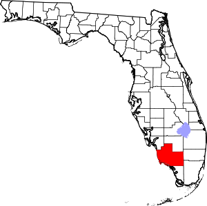
Glades County is a county located in the Florida Heartland region of the U.S. state of Florida. As of the 2020 census, the population was 12,126, making it the fourth-least populous county in Florida. Its county seat is Moore Haven.

<span class="mw-page-title-main">Hendry County, Florida</span> County in Florida, United States

Hendry County is a county in the Florida Heartland region of the U.S. state of Florida. As of the 2020 census, the population was 39,619, down from 42,022 at the 2010 census. Its county seat is LaBelle.

<span class="mw-page-title-main">Lee County, Florida</span> County in Florida, United States

Lee County is located in southwestern Florida, United States, on the Gulf Coast. As of the 2020 census, its population was 760,822. In 2022, the population was 822,453, making it the eighth-most populous county in the state. The county seat is Fort Myers, with a population of 86,395 as of the 2020 census, and the largest city is Cape Coral, with an estimated 2020 population of 194,016.

<span class="mw-page-title-main">Martin County, Florida</span> County in Florida, United States

Martin County is a county located in the southeastern part of the state of Florida, in the United States. As of the 2020 census, the population was 158,431. Its county seat is Stuart. Martin County is in the Port St. Lucie, FL Metropolitan Statistical Area.

<span class="mw-page-title-main">Monroe County, Florida</span> County in Florida, United States

Monroe County is a county in the state of Florida. As of the 2020 census, the population was 82,874. Its county seat is Key West. Monroe County includes the islands of the Florida Keys and comprises the Key West-Key Largo Micropolitan Statistical Area. Over 99.9% of the county's population lives on the Florida Keys. The mainland, which is part of the Everglades, comprises 87% of the county's land area and is virtually uninhabited with only 17 people recorded in the 2020 census.

<span class="mw-page-title-main">Okeechobee County, Florida</span> County in Florida, United States

Okeechobee County is a county located in the Florida Heartland region of the state of Florida. As of the 2020 census, the population was 39,644. The county seat is Okeechobee.

<span class="mw-page-title-main">Chokoloskee, Florida</span> Census-designated place in Florida

Chokoloskee is an unincorporated community and census-designated place (CDP) located at the edge of the Ten Thousand Islands in Collier County, Florida, United States. The population was 359 at the 2010 census. It is part of the Naples–Marco Island Metropolitan Statistical Area.

<span class="mw-page-title-main">Everglades City, Florida</span> City in Florida

Everglades City is a city in Collier County, Florida, United States, of which it was once the county seat. The City of Everglades City is part of the Naples–Immokalee–Marco Island Metropolitan Statistical Area, which is included in the Cape Coral-Fort Myers-Naples Combined Statiscal Area. The Gulf Coast Visitor Center for Everglades National Park is located in Everglades City. As of the 2020 US census, the population was 352, down from 400 in the 2010 US census.

<span class="mw-page-title-main">Immokalee, Florida</span> Census-designated place in Florida, United States

Immokalee is an unincorporated community and census-designated place in Collier County, Florida, United States. The population was 24,557 at the 2020 census. It is part of the Naples–Marco Island metropolitan area.

<span class="mw-page-title-main">Marco Island, Florida</span> City in Florida, United States

Marco Island is a city and barrier island in Collier County, Florida, 20 miles (32 km) south of Naples on the Gulf Coast of the United States. It is the largest barrier island in Southwest Florida's Ten Thousand Islands area, which extends southerly to Cape Sable. Marco Island is home to an affluent beach community with resort amenities.

<span class="mw-page-title-main">Naples, Florida</span> City in Florida, United States

Naples is a city in Collier County, Florida, United States. As of the 2020 census, the population was 19,115. Naples is a principal city of the Naples–Marco Island metropolitan area, which had a population of about 375,752 as of 2020. Naples' USPS City population includes most of the communities in Collier County with the notable exceptions of Immokalee, Marco Island, Ave Maria, Everglades City and a few others, and thus Naples' USPS City population is approximately 333,083.

<span class="mw-page-title-main">Orangetree, Florida</span> Census-designated place in Florida

Orangetree is a census-designated place (CDP) in Collier County, Florida, United States. The population was 4,406 at the 2010 census, up from 950 in 2000. It is part of the Naples–Marco Island Metropolitan Statistical Area.

<span class="mw-page-title-main">Plantation Island, Florida</span> Census-designated place in Florida

Plantation Island is a census-designated place (CDP) in Collier County, Florida, United States. The population was 163 at the 2010 census. It is part of the Naples–Marco Island Metropolitan Statistical Area.

<span class="mw-page-title-main">Clewiston, Florida</span> City in Florida, United States

Clewiston is a city in Hendry County, Florida, United States. Its location is 80 miles (130 km) northwest of Fort Lauderdale on the Atlantic coastal plain. The population was 7,327 at the 2020 census.

<span class="mw-page-title-main">Bonita Springs, Florida</span> City in Florida, United States

Bonita Springs is a city in Lee County, Florida, United States. The population was 53,644 at the 2020 census. It is part of the Cape Coral-Fort Myers, Florida Metropolitan Statistical Area, on the state's southwest coast.

<span class="mw-page-title-main">Southwest Florida</span> Region in Florida

Southwest Florida is the region along the southwest Gulf coast of the U.S. state of Florida. The area is known for its beaches, subtropical landscape, and winter resort economy.

<span class="mw-page-title-main">Area code 239</span> Area code for southwestern Florida

Area code 239 is a telephone area code in the North American Numbering Plan (NANP) for a part of Southwestern Florida. The numbering plan area (NPA) includes Lee and Collier counties, small parts of Hendry and Charlotte counties and the Everglades National Park in Mainland Monroe County. The area code was activated for service on March 11, 2002, in an area code split in which the southern half of NPA 941, from North Fort Myers, was renumbered with 239. A permissive dialing period ended on March 10, 2003.

<span class="mw-page-title-main">Florida State Road 29</span> Highway in Florida

State Road 29 is a state highway that runs north–south through Southwest Florida. A rural road, it runs mostly through uninhabited farmland in its northern half, and along wetlands in its southern half.

<span class="mw-page-title-main">Everglades Airpark</span> Airport in Collier County, Florida

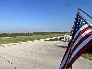
Everglades Airpark is a public-use airport located 1 mile (1.6 km) southwest of the central business district of the city of Everglades City in Collier County, Florida, United States. The airport is publicly owned.

References

  1. "Collier County, Florida Demographics and Housing 2020 Decennial Census".
  2. "Find a County". National Association of Counties. Archived from the original on May 31, 2011. Retrieved June 7, 2011.
  3. "Revised Delineations of Metropolitan Statistical Areas, Micropolitan Statistical Areas, and Guidance on the Uses of the Delineations of These Areas" (PDF). Executive Office of the President. July 21, 2023. p. 64. Retrieved July 21, 2023.
  4. Widmer, Randolph J. (1988). "The Prehistory of Southwest Florida". Evolution of the Calusa: a Stratified Non-Agricultural Chiefdom on the Southwest Florida Coast . University of Alabama Press. p.  72. ISBN   9780817303587.
  5. Clark, James C. (2014). A Concise History of Florida. Arcadia. p. 150. ISBN   9781625851536.
  6. "US Gazetteer files: 2010, 2000, and 1990". United States Census Bureau. February 12, 2011. Retrieved April 23, 2011.
  7. "Annual Estimates of the Resident Population for Counties: April 1, 2020 to July 1, 2023". United States Census Bureau. Retrieved March 31, 2024.
  8. "U.S. Decennial Census". United States Census Bureau. Retrieved June 13, 2014.
  9. "Historical Census Browser". University of Virginia Library. Archived from the original on August 11, 2012. Retrieved June 13, 2014.
  10. "Population of Counties by Decennial Census: 1900 to 1990". United States Census Bureau. Retrieved June 13, 2014.
  11. "Census 2000 PHC-T-4. Ranking Tables for Counties: 1990 and 2000" (PDF). United States Census Bureau. Retrieved June 13, 2014.
  12. "State & County QuickFacts". United States Census Bureau. Archived from the original on August 7, 2011. Retrieved February 12, 2014.
  13. "Collier County, Florida Demographics and Housing 2020 Decennial Census".
  14. "U.S. Census website". United States Census Bureau . Retrieved May 14, 2011.
  15. "Collier County Census Overview". colliercountyfl.gov.
  16. "POPULATION & DEMOGRAPHICS | Collier County, FL". www.colliercountyfl.gov.
  17. "Explore Census Data". data.census.gov. Retrieved February 12, 2022.
  18. "Explore Census Data". data.census.gov. Retrieved February 12, 2022.
  19. "Locations, hours, maps". Collier County Public Library. Retrieved April 22, 2016.
  20. Sullivan, Robert David; ‘How the Red and Blue Map Evolved Over the Past Century’; America Magazine in The National Catholic Review; June 29, 2016
  21. "Collier County Supervisor of Elections" . Retrieved November 21, 2022.
  22. Leip, David. "Dave Leip's Atlas of U.S. Presidential Elections". uselectionatlas.org.
  23. "A ton of Burmese pythons removed in 90 days". March 17, 2016.
  24. "South Florida has pythons by the ton, literally".
  25. "South Florida has pythons by the ton, literally". Miami Herald .

Government links/Constitutional offices

Special districts

Judicial branch

Recycling Center

26°05′N81°24′W / 26.08°N 81.40°W / 26.08; -81.40