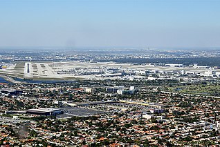
Miami International Airport — also known as MIA and historically as Wilcox Field — is the primary international airport serving Miami and its surrounding metropolitan area, in the U.S. state of Florida. It hosts over 1,000 daily flights to 185 domestic and international destinations, including most countries in Latin America. The airport is in an unincorporated area in Miami-Dade County, 8 miles (13 km) west-northwest of Downtown Miami, in metropolitan Miami, adjacent to the cities of Miami and Miami Springs, and the village of Virginia Gardens. Nearby cities include Hialeah, Doral, and the census-designated place of Fontainebleau.

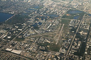
Fort Lauderdale–Hollywood International Airport – also known as Fort Lauderdale Airport and historically as Merle Fogg Field and Broward County International Airport – is a major public airport located in Broward County, Florida, United States, roughly 3 miles (4.8 km) southwest of downtown Fort Lauderdale and 21 miles (34 km) north of Miami. The second busiest of the Miami metropolitan area's commercial airports, it is located off Interstate 595, Interstate 95, U.S. Route 1, Florida State Road A1A, and Florida State Road 5, and is bounded by the cities of Fort Lauderdale, Hollywood, and Dania Beach.

Naples Airport, formerly known as Naples Municipal Airport, is a public use airport located two nautical miles (4 km) northeast of the central business district of Naples, the most populous city and county seat of Collier County, Florida. It is owned by the Naples Airport Authority. The airport is home to flight schools, air charter operators, car rental agencies, and corporate aviation and non-aviation businesses. The airport is also a central location for public services, including fire/rescue services, mosquito control, the Collier County Sheriff's Aviation Unit and other community services.

ValuJet Airlines Flight 592 was a regularly scheduled flight from Miami to Atlanta in the United States. On May 11, 1996, the ValuJet Airlines McDonnell Douglas DC-9 operating the route crashed into the Florida Everglades about ten minutes after departing Miami as a result of a fire in the cargo compartment caused by mislabeled and improperly stored hazardous cargo. All 110 people on board were killed.

Miami Executive Airport, formerly known until 2014 as Kendall-Tamiami Executive Airport, is a public airport in unincorporated Miami-Dade County, Florida, 15 miles (24 km) southwest of Downtown Miami.Operated by the Miami-Dade Aviation Department, the airport is one of Florida's busiest general aviation facilities. It supports corporate, recreational, flight training, and government aviation operations.

Miami Air International was an American charter airline based in Miami-Dade County, Florida, United States. It operated worldwide passenger charter flights for diverse groups including cruise operators, professional sports teams and the United States military. It was based at Miami International Airport. Miami Air's customers included incentive groups, sports teams, Fortune 500 companies, major cruise lines, entertainers, political candidates and the United States government. Under the Civil Reserve Air Fleet (CRAF) program, Miami Air was contracted by the United States Air Force Air Mobility Command for transporting troops and cargo.

Orlando Executive Airport is a public airport three miles (6 km) east of downtown Orlando, in Orange County, Florida. It is owned and operated by the Greater Orlando Aviation Authority (GOAA) and serves general aviation.
The Tamiami Trail is the southernmost 284 miles (457 km) of U.S. Highway 41 (US 41) from State Road 60 (SR 60) in Tampa to US 1 in Miami. A portion of the road also has the hidden designation of State Road 90 (SR 90).
Fort Lauderdale Executive Airport is a general aviation airport located within the city limits of Fort Lauderdale, in Broward County, Florida, United States, five miles (8.0 km) north of downtown Fort Lauderdale. It is a division of the Transportation and Mobility Department of the City of Fort Lauderdale.

Big Cypress National Preserve is a United States National Preserve located in South Florida, about 45 miles west of Miami on the Atlantic coastal plain. The 720,000-acre (2,900 km2) Big Cypress, along with Big Thicket National Preserve in Texas, became the first national preserves in the United States National Park System when they were established on October 11, 1974. In 2008, Florida film producer Elam Stoltzfus featured the preserve in a PBS documentary.

Daytona Beach International Airport is a county-owned airport located three miles (5 km) southwest of Daytona Beach, next to Daytona International Speedway, in Volusia County, Florida, United States. The airport has 3 runways, a six-gate domestic terminal, and an international terminal. Daytona Beach is the headquarters of Embry-Riddle Aeronautical University.

Grant County International Airport is a public use airport located six miles (10 km) northwest of the central business district of Moses Lake in Grant County, Washington, United States. Formerly a military facility, the airport is owned by the Port of Moses Lake, and its 13,500-foot (4,110 m) runway is the 17th longest in the U.S.
North Palm Beach County Airport, also known as North County Airport, is an uncontrolled (non-towered) general aviation airport located 12 nautical miles northwest of West Palm Beach off the Bee Line Highway in Palm Beach Gardens, Florida. The airport is owned by Palm Beach County and operated by the Palm Beach County Airports Department. Opened in 1994, it is the county's newest airport. It is located next to the site of the "fake" town of Apix, Florida.

Miami-Opa Locka Executive Airport is a joint civil-military airport located in Miami-Dade County, Florida 11 mi (18 km) north of downtown Miami. Part of the airport is in the city limits of Opa-locka. The National Plan of Integrated Airport Systems for 2011–2015 called it a general aviation reliever airport.

Raleigh Exec: The Raleigh Executive Jetport or Raleigh Exec Jetport at Sanford-Lee County is a public use airport located seven nautical miles northeast of the central business district of Sanford, a city in Lee County, North Carolina, United States. It is owned by the Sanford-Lee County Regional Airport Authority and was previously known as Sanford-Lee County Regional Airport. This airport is included in the National Plan of Integrated Airport Systems for 2011–2015, which categorized it as a reliever airport for Raleigh-Durham International Airport.

Lakeland Linder International Airport is a public airport five miles southwest of Lakeland, in Polk County, Florida. The Federal Aviation Administration (FAA) National Plan of Integrated Airport Systems for 2017–2021 categorized it as a national reliever facility for Tampa International Airport. The airport has a Class 1 Federal Aviation Regulation (FAR) Part 139 operating certificate allowing passenger airline flights.
Miami Homestead General Aviation Airport is a county-owned public-use airport in unincorporated Miami-Dade County, Florida, United States, located 4.6 miles (7.4 km) northwest of the central business district of Homestead.
Everglades Airpark is a public-use airport located 1 mile (1.6 km) southwest of the central business district of the city of Everglades City in Collier County, Florida, United States. The airport is publicly owned.

Darlington County Airport (Jetport) (ICAO: KUDG, FAA LID: UDG) is a county-owned, public-use airport located nine nautical miles (10 mi, 17 km) north of the central business district of Darlington, a city in Darlington County, South Carolina, United States. It is included in the National Plan of Integrated Airport Systems for 2011–2015, which categorized it as a general aviation facility. The airport does not have scheduled commercial airline service.

The "Environmental Impact of the Big Cypress Swamp Jetport", unofficially known as the "Leopold Report" or the "Leopold-Marshall Report", was a report authored by hydrologist Luna Leopold of the United States Geological Service for the Department of the Interior and officially released on September 17, 1969. Arthur R. Marshall, formerly of the United States Fish and Wildlife Service, helped draft the report. It is considered the first ecological impact report in the state of Florida.


