Goulburn Airport is a general aviation airport located 7 km (4.3 mi) south of Goulburn, New South Wales. Throughout the 1990s, suggestions were put forward to have Goulburn airport as a secondary international airport to service Sydney.
Taos Regional Airport is a public use airport eight nautical miles (15 km) northwest of the central business district of Taos, in Taos County, New Mexico, United States. It is owned by the Town of Taos. FAA's National Plan of Integrated Airport Systems for 2009–2013 classifies it as a general aviation airport.
Harbor Springs Municipal Airport, also known as Harbor Springs Airport, is a public airport located three miles (5 km) east of the central business district of Harbor Springs, a city in Emmet County, Michigan, United States. It is included in the Federal Aviation Administration (FAA) National Plan of Integrated Airport Systems for 2017–2021, in which it is categorized as a local general aviation facility.
Marina Municipal Airport is a public airport located two miles (3 km) east of the central business district of Marina, a city in Monterey County, California, United States. It is owned by the City of Marina.
In the United States, skydiving is a self-regulated sport, which means skydivers, in the US, voluntarily follow a set of basic safety requirements established by the U.S. Parachute Association. Federal requirements can be found in the Federal Aviation Regulations. Most of the regulations concern the aircraft, pilot and rules of flight. However, 14 CFR Part 105, "Parachute Operations" regulates when and where jumps may be made and designates the requirements for parachute equipment and packing. For example, 14 CFR Part 105 requires the person packing either the main chute or the reserve parachute to be a certificated rigger, which means he or she has taken an FAA-approved training course and has passed rigorous FAA testing.
Eagles Nest Airport is a privately owned public-use airport serving general aviation aircraft. It was upgraded in April 1989, but had been in operation since the 1960s. It is located two nautical miles north of the community of West Creek, in Eagleswood Township, New Jersey.

Clare Municipal Airport is a public airport located one mile (2 km) east of downtown Clare, a city in Clare County, Michigan, United States. The airport became active in 1941. It serves general aviation for Clare and the surrounding area. It is included in the Federal Aviation Administration (FAA) National Plan of Integrated Airport Systems for 2017–2021, in which it is categorized as a local general aviation facility.

Mineral Wells Airport is a public airport four miles southeast of Mineral Wells, Texas. The National Plan of Integrated Airport Systems for 2011–2015 called it a general aviation facility. It is owned and operated by the city of Mineral Wells. The airport, and the city, lie in Palo Pinto County and Parker County. The terminal is in Parker County.
Fremont Municipal Airport is a city-owned public-use airport located three nautical miles (6 km) southwest of the central business district of Fremont, a city in Newaygo County, Michigan, United States. The airport is uncontrolled, and is used for general aviation purposes. Skydiving and ultralight activity are also conducted at the field. It is included in the Federal Aviation Administration (FAA) National Plan of Integrated Airport Systems for 2017–2021, in which it is categorized as a local general aviation facility.
Grand Haven Memorial Airpark is a public airport owned and operated by the City of Grand Haven located 2 miles (3.2 km) southeast of Grand Haven, Michigan. The airport is uncontrolled, and is used for general aviation purposes. It is included in the Federal Aviation Administration (FAA) National Plan of Integrated Airport Systems for 2017–2021, in which it is categorized as a local general aviation facility.
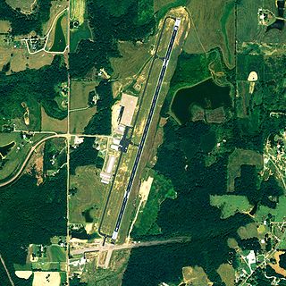
Cullman Regional Airport-Folsom Field is a public-use airport located five nautical miles north of the central business district of Cullman, a city in Cullman County, Alabama, United States. It is owned by the City and County of Cullman.

Elizabethtown Regional Airport, also known as Addington Field, is a public use airport located four nautical miles (7 km) west of the central business district of Elizabethtown, a city in Hardin County, Kentucky, United States. The airport is owned by the Elizabethtown Airport Board. It is used for general aviation, but current exploration of commercial aviation is underway.
Perris Valley Airport is a privately owned and operated airport open to public use and located one mile (1.6 km) southeast of Perris, serving Riverside County, California, United States. It has one runway and is used for general aviation and extensive skydiving. The airport operates from dawn to dusk daily year-round.
Meyers–Diver's Airport is located in Tecumseh, Michigan, United States. It is at an elevation of 815 feet. It is owned by Al Meyers Airport, Inc. and managed by Andy Alto.
Hastings Airport is a public use airport located three nautical miles (6 km) west of the central business district of Hastings, a city in Barry County, Michigan, United States. It is owned by the city and county and is also known as Hastings City/Barry County Airport.

Eloy Municipal Airport is a public use non-towered airport located 3.5 miles northwest of the central business district of Eloy, a city in Pinal County, Arizona, United States. It is 50 miles southeast of Phoenix Sky Harbor International Airport.
Parker County Airport is a privately owned public airport in Hudson Oaks, Parker County, Texas, United States. The airport serves the city of Weatherford, and is located approximately 5 nautical miles (9.3 km) east of the central business district.

Shannon Airport is a public use airport located two miles south of the City of Fredericksburg, Virginia, United States. It was opened in October 1950 by Sidney L. Shannon Jr in honor of his father, Sidney Shannon Sr, an early investor in Eastern Airlines.
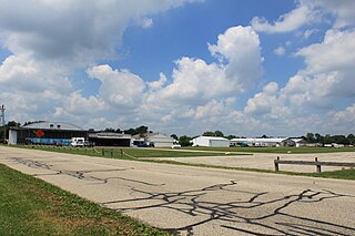
Taylorville Municipal Airport is a civil public-use airport in Taylorville, Illinois. It is owned by the City of Taylorville. The airport is located near both Springfield's Abraham Lincoln Capital Airport and Decatur Airport. It has been active since March 1947.
Napoleon Airport is a privately owned, public use airport located 1 mile northwest of Napoleon in Jackson County, Michigan. The airport sits on 95 acres at an elevation of 963 feet.