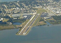
Merritt Island Airport | |||||||||||
|---|---|---|---|---|---|---|---|---|---|---|---|
 | |||||||||||
| Summary | |||||||||||
| Airport type | Public | ||||||||||
| Owner | Titusville-Cocoa Airport Authority | ||||||||||
| Location | 900 Airport Road Merritt Island, Florida | ||||||||||
| Elevation AMSL | 5.9 ft / 1.8 m | ||||||||||
| Coordinates | 28°20′30″N080°41′08″W / 28.34167°N 80.68556°W | ||||||||||
 | |||||||||||
| Runways | |||||||||||
| |||||||||||
Merritt Island Airport( IATA : COI, ICAO : KCOI, FAA LID : COI) is a general aviation public airport under the administration of the Titusville-Cocoa Airport Authority. It located in Merritt Island, Brevard County, Florida, United States, northwest of Patrick Space Force Base.

