Related Research Articles

Bay County is a county on the Emerald Coast in Northwest Florida. As of the 2020 census, the population was 175,216. Its county seat is Panama City.
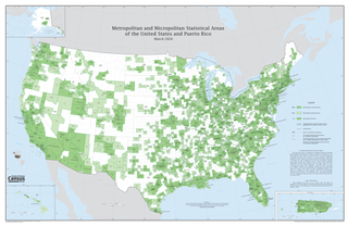
In the United States, a metropolitan statistical area (MSA) is a geographical region with a relatively high population density at its core and close economic ties throughout the region. Such regions are not legally incorporated as a city or town would be and are not legal administrative divisions like counties or separate entities such as states. That makes the precise definition of any given metropolitan area vary with the source. The statistical criteria for a standard metropolitan area were defined in 1949 and redefined as a metropolitan statistical area in 1983.

Panama City is a city in and the county seat of Bay County, Florida, United States. Located along U.S. Highway 98 (US 98), it is the largest city between Tallahassee and Pensacola. It is also the most populated city of the Panama City–Lynn Haven, Florida metropolitan statistical area. Panama City was severely damaged when Hurricane Michael made landfall as a Category 5 hurricane on October 10, 2018. As of the 2020 census, the population was 35,392, down from the figure of 36,484 at the 2010 census.

The Florida Panhandle is the northwestern part of the U.S. state of Florida. It is a salient roughly 200 miles long, bordered by Alabama on the north and the west, Georgia on the north, and the Gulf of Mexico to the south. Its eastern boundary is arbitrarily defined. It is defined by its southern culture and rural geography relative to the rest of Florida, as well as closer cultural links to French-influenced Louisiana, Mississippi, and Alabama. Its major communities include Pensacola, Navarre, Destin, Panama City Beach, and Tallahassee.
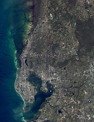
The Tampa Bay area is a major metropolitan area surrounding Tampa Bay on the Gulf Coast of Florida in the United States. It includes the main cities of Tampa, St. Petersburg, and Clearwater. It is the 18th-largest metropolitan area in the United States, with a population of 3,175,275 as of the 2020 U.S. Census.
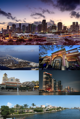
The Miami metropolitan area, officially known as the Miami–Fort Lauderdale–West Palm Beach Metropolitan Statistical Area, is a coastal metropolitan area in the southeastern part of the state of Florida. It is the ninth-largest metropolitan statistical area in the United States, the fifth-largest in the Southern United States, and the largest in the state of Florida. With a population of 6.14 million, it has more people than 31 of the nation's 50 states as of 2022. It comprises the three most populated counties in the state: Miami-Dade County, Broward County, and Palm Beach County.

The Louisville metropolitan area is the 43rd largest metropolitan statistical area (MSA) in the United States. It had a population of 1,395,855 in 2020 according to the latest official census, and its principal city is Louisville, Kentucky.

The Orlando metropolitan area, commonly referred to as Greater Orlando, Metro Orlando, Central Florida as well as for U.S. Census purposes as the Orlando–Kissimmee–Sanford, Florida Metropolitan Statistical Area, is a metropolitan area in the central region of the U.S. state of Florida. Its principal cities are Orlando, Kissimmee and Sanford. The U.S. Office of Management and Budget defines it as consisting of the counties of Lake, Orange, Osceola, and Seminole.

The Blacksburg-Christiansburg Metropolitan Statistical Area, formerly the Blacksburg-Christiansburg-Radford Metropolitan Statistical Area, is a Metropolitan Statistical Area (MSA) as defined by the United States Office of Management and Budget (OMB) located in the New River Valley of Southwest Virginia. As of the 2020 census, the MSA had a population of 181,863.

The Pensacola metropolitan area is the metropolitan area centered on Pensacola, Florida. It is also known as the Pensacola-Ferry Pass-Brent Metropolitan Statistical Area, a metropolitan statistical area (MSA) used for statistical purposes by the United States Census Bureau and other agencies. The Pensacola Standard Metropolitan Statistical Area was first defined in 1958, with Pensacola as the principal city, and included Escambia and Santa Rosa counties. The SMA was renamed Pensacola-Ferry Pass-Brent MSA in 2003, with the unincorporated census-designated places Ferry Pass and Brent added as principal cities. The population of the MSA in the 2020 census was 511,502.

The Tallahassee Metropolitan Statistical area is the metropolitan area centered on Tallahassee, Florida.

The Sarasota metropolitan area is a metropolitan area located in Southwest Florida. The metropolitan area is defined by the Office of Management and Budget (OMB) as the North Port–Bradenton-Sarasota Metropolitan Statistical Area, a metropolitan statistical area (MSA) consisting of Manatee County and Sarasota County. The principal cities listed by the OMB for the MSA are North Port, Bradenton, Sarasota, Lakewood Ranch, and Venice. At the 2020 census, the MSA had a population of 833,716. The Census Bureau estimates that its population was 891,411 in 2022.

The Deltona–Daytona Beach–Ormond Beach, Florida Metropolitan Statistical Area is a metropolitan statistical area (MSA) in central and the north portions of Florida consisting of Volusia and Flagler counties in the state of Florida. As of 2013, it is the 88th-largest MSA in the United States, with a census-estimated population of 600,756.

The Gainesville metropolitan area is the metropolitan area in North Central Florida that includes Alachua, Levy, and Gilchrist counties, with Gainesville, Florida the principal city. The metropolitan area had a population of 339,247 in 2020.

The U.S. State of North Carolina currently has 49 statistical areas that have been delineated by the Office of Management and Budget (OMB). On March 6, 2020, the OMB delineated ten combined statistical areas, 17 metropolitan statistical areas, and 22 micropolitan statistical areas in North Carolina.

The Knoxville metropolitan area, commonly known as Greater Knoxville, is a metropolitan statistical area (MSA) centered on Knoxville, Tennessee, the third largest city in Tennessee and the largest city in East Tennessee. It is the third largest metropolitan area in Tennessee. In 2020, the Knoxville metro area had a population of 879,773. The Knoxville–Morristown–Sevierville Combined Statistical Area (CSA) had a population of 1,156,861 according to the census bureau in 2020.

The city of Portland, Maine, is the hub city of a metropolitan area in southern Maine, United States. The region is commonly known as Greater Portland or the Portland metropolitan area. For statistical purposes, the U.S. federal government defines three different representations of the Portland metropolitan area. The Portland–South Portland–Biddeford, Maine, metropolitan statistical area is a region consisting of three counties in Maine, anchored by the city of Portland and the smaller cities of South Portland and Biddeford. As of the 2010 census, the MSA had a population of 514,098. A larger combined statistical area (CSA), the Portland–Lewiston–South Portland combined statistical area, is defined as the combination of this metropolitan statistical area (MSA) with the adjacent Lewiston–Auburn MSA. The CSA comprises four counties in southern Maine. The Portland–South Portland metropolitan New England city and town area is defined on the basis of cities and towns rather than entire counties. It consists of most of Cumberland and York counties plus the town of Durham in Androscoggin County. The Greater Portland area has emerged as an important center for the creative economy, which is also bringing gentrification.
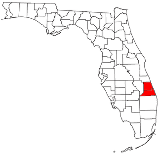
The Port St. Lucie, FL Metropolitan Statistical Area is a metropolitan statistical area (MSA) that includes St. Lucie and Martin counties in the Treasure Coast region of Florida. The MSA was defined by the Office of Management and Budget with its current composition in 1983 as the Ft. Pierce, FL MSA, with Fort Pierce as the principal city. The name was changed to Ft. Pierce-Port St. Lucie, FL MSA in 1992, with the addition of Port St. Lucie as a principal city. The name of the MSA was changed to Port St. Lucie-Ft. Pierce, FL MSA in 2003, and to Port St. Lucie, FL MSA in 2006, with the removal of Fort Pierce as a principal city. The Port St. Lucie MSA is included in the Miami-Port St. Lucie-Fort Lauderdale, FL Combined Statistical Area.
The United States federal government defines and delineates the nation's metropolitan areas for statistical purposes, using a set of standard statistical area definitions. As of 2020, the U.S. Office of Management and Budget (OMB) defined and delineated 392 metropolitan statistical areas (MSAs) and 547 micropolitan statistical areas (μSAs) in the United States and Puerto Rico. Many of these 939 MSAs and μSAs are, in turn, components of larger combined statistical areas (CSAs) consisting of adjacent MSAs and μSAs that are linked by commuting ties; as of 2020, 551 metropolitan and micropolitan areas are components of the 175 defined CSAs. A collective term for MSAs, μSAs, and CSAs is primary statistical areas (PSAs), though that term is not used by OMB.

The Crestview–Fort Walton Beach–Destin, Florida, Metropolitan Statistical Area, as defined by the United States Census Bureau, is a metropolitan area consisting of Okaloosa and Walton counties in northwest Florida, with the principal cities of Crestview, Fort Walton Beach, and Destin. As of the 2010 census, the MSA had a population of 235,865, and a 2012 population estimate of 247,665.
References
- ↑ "Revised Delineations of Metropolitan Statistical Areas, Micropolitan Statistical Areas, and Guidance on the Uses of the Delineations of These Areas" (PDF). Executive Office of the President. July 21, 2023. p. 66. Retrieved July 27, 2023.
- ↑ "Metro Area History 1950–2020". U.S. Census Bureau. March 2020. Row 3803. Retrieved July 27, 2023.