Walton County, Florida

Last updated

Walton County
DeFuniak Springs Hist Dist crths02.jpg
Walton County Courthouse
Flag of Walton County, Florida.svg
Walton County FL logo.png
Map of Florida highlighting Walton County.svg
Location within the U.S. state of Florida
Florida in United States.svg
Florida's location within the U.S.
Coordinates: 30°37′N86°10′W / 30.61°N 86.17°W / 30.61; -86.17
CountryFlag of the United States.svg United States
StateFlag of Florida.svg  Florida
FoundedDecember 29, 1824
Named for George Walton Jr.
Seat DeFuniak Springs
Largest city Miramar Beach
Area
  Total1,240 sq mi (3,200 km2)
  Land1,038 sq mi (2,690 km2)
  Water202 sq mi (520 km2)  16.3%
Population
 (2020)
  Total75,305 Increase2.svg
  Density61/sq mi (24/km2)
Time zone UTC−6 (Central)
  Summer (DST) UTC−5 (CDT)
Congressional districts 1st, 2nd
Website www.co.walton.fl.us

Walton County is located on the Emerald Coast in the northwestern part of the U.S. state of Florida, with its southern border on the Gulf of Mexico. As of the 2020 census, the population was 75,305. [1] Its county seat is DeFuniak Springs. [2] The county is home to the highest natural point in Florida: Britton Hill, at 345 feet (105 m). Walton County is included in the Crestview–Fort Walton Beach–Destin Metropolitan Statistical Area.

Contents

History

Walton County was organized by European Americans in 1824. It was named for Colonel George Walton Jr., secretary of the Florida Territory from 1821 to 1826. Walton, the son of George Walton, a signer of the Declaration of Independence, was born August 15, 1786, in Augusta, Georgia, and died March 20, 1859, in Petersburg, Virginia. [3]

Between 1763 and 1783 the territory that has since become Walton County was part of the colony of British West Florida. During this time British settlers permanently settled in the area, becoming the first English-speaking people to permanently reside in what is now Walton County. During this period Scottish settlers migrated from the backcountry of the Carolinas and settled in the Defuniak Springs area while English settlers, most of whom were either farmers or fishermen, settled in the southern portion of the county by the sea, settling throughout the area that has since become Santa Rosa Beach, Sandestin, Miramar Beach, Point Washington, Seaside and Topsail Hill Preserve State Park and Point Washington State Forest.

While the Scottish settlers had come from a recently established Scottish-majority settlement in North Carolina, the English settlers came largely from the English regions of Norfolk, Dorset and the western half of Sussex. Both the Scots village in the northern portion of the county and the English community along the coast were largely self-contained and had economies that were entirely operational without external trade, as all products in use were made within the two respective communities, and the only external trade was between the Scots in Defuniak Springs and the English farmers/fishermen by the coast. Neither community exported the goods they produced for profit, nor did they have any imported goods at all as both communities relied on self-produced subsistence agriculture. [4] [5] [6] The original settlements were in the Euchee (Yuchi) Valley, near the landing on the Choctawhatchee River that was maintained by a mixed-race Yuchi named Sam Story, whose mother was Yuchi and father was an early Scots trader in the area. The white settlers founded one of the first Presbyterian churches in Northwest Florida. It is still an operating parish and has a historical cemetery.

When the Spanish regained control of Florida in 1783, roughly two-thirds of the British settlers in Pensacola left the colony to find permanent habitation elsewhere, including in the Bahamas and Bermuda, however none of the English or Scottish settlers in what has since become Walton County left with them. The Spanish came to regard the English and Scottish settlers in what has since become Walton County as "stubborn" and "ungovernable" as the Spanish were unable to make them obey Spanish law. They unanimously refused to convert to Catholicism, despite the fact that Spanish law said they were only allowed to remain in Florida if they did so and the Spanish were unable to compel them to pay taxes to the local Spanish government. As settlers from the newly created United States of America began migrating into north Florida the English and Scottish settlers in what has since become Walton County became gradually absorbed into this community, which would subsequently become the majority population in North Florida. [4] [5] [6] [7]

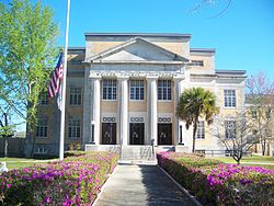
In 1860, there were roughly 573 military aged men in Walton County. Of that population, 62, or 11%, went to serve in the Union unit, the 1st Florida Cavalry Regiment that was mustered in on October 29, 1863. [8]

In 1995, three planned communities designed by Andrés Duany and Elizabeth Plater-Zyberk of the Duany Plater-Zyberk & Company were founded. The communities, named Alys Beach, Seaside, and Rosemary Beach are examples of a style of urban planning known as New Urbanism. [9] [10] The final plan for Seaside was complete around 1985. [9]

Seaside was used as the main filming location of the 1998 film The Truman Show . [11]

Geography

Britton Hill, Florida's highest point at 345 feet (105 m), is located in northern Walton County Britton Hill, Florida.JPG
Britton Hill, Florida's highest point at 345 feet (105 m), is located in northern Walton County

According to the U.S. Census Bureau, the county has a total area of 1,240 square miles (3,200 km2), of which 1,038 square miles (2,690 km2) is land and 202 square miles (520 km2) (16.3%) is water. [12] The county is one of the largest in area in the state, stretching from the Alabama state line to the Emerald Coast.

Adjacent counties

National protected areas

Demographics

Historical population
CensusPop.Note
1830 1,207
1840 1,46121.0%
1850 1,81724.4%
1860 3,03767.1%
1870 3,0410.1%
1880 4,20138.1%
1890 4,81614.6%
1900 9,34694.1%
1910 16,46076.1%
1920 12,119−26.4%
1930 14,57620.3%
1940 14,246−2.3%
1950 14,7253.4%
1960 15,5765.8%
1970 16,0873.3%
1980 21,30032.4%
1990 27,76030.3%
2000 40,60146.3%
2010 55,04335.6%
2020 75,30536.8%
2023 (est.)86,354 [13] 14.7%
U.S. Decennial Census [14]
1790-1960 [15] 1900-1990 [16]
1990-2000 [17] 2010-2015 [18] 2019 [19] 2020 [1]
Walton County racial composition as of 2020
(NH = Non-Hispanic) [lower-alpha 1]
RacePop 2010 [22] Pop 2020 [23] % 2010% 2020
White (NH)46,85760,64485.13%80.53%
Black or African American (NH)3,1473,2945.72%4.37%
Native American or Alaska Native (NH)4634150.84%0.55%
Asian (NH)4919070.89%1.2%
Pacific Islander (NH)37380.07%0.05%
Some Other Race (NH)623070.11%0.41%
Mixed/Multi-Racial (NH)1,0653,5131.93%4.67%
Hispanic or Latino 2,9216,1875.31%8.22%
Total55,04375,305100.00%100.00%

As of the 2020 United States census, there were 75,305 people, 28,635 households, and 20,034 families residing in the county.

As of the census [24] of 2000, there were 40,601 people, 16,548 households, and 11,120 families residing in the county. The population density was 38 people per square mile (15 people/km2). There were 29,083 housing units at an average density of 28 per square mile (11/km2). The racial makeup of the county was 88.41% White, 6.98% Black or African American, 1.28% Native American, 0.45% Asian, 0.04% Pacific Islander, 0.75% from other races, and 2.09% from two or more races. 2.17% of the population were Hispanic or Latino of any race.

There were 16,548 households, out of which 26.40% had children under the age of 18 living with them, 53.00% were married couples living together, 10.10% had a female householder with no husband present, and 32.80% were non-families. 27.10% of all households were made up of individuals, and 10.10% had someone living alone who was 65 years of age or older. The average household size was 2.35 and the average family size was 2.83.

In the county, the population was spread out, with 21.70% under the age of 18, 7.10% from 18 to 24, 28.50% from 25 to 44, 26.90% from 45 to 64, and 15.80% who were 65 years of age or older. The median age was 40 years. For every 100 females there were 105.20 males. For every 100 females age 18 and over, there were 105.00 males.

The median income for a household in the county was $32,407, and the median income for a family was $37,663. Males had a median income of $26,799 versus $21,208 for females. The per capita income for the county was $18,198. About 11.60% of families and 14.40% of the population were below the poverty line, including 21.00% of those under age 18 and 10.90% of those age 65 or over.

Government

County government

PositionNameParty
 Commissioner, District 1Boots McCormick Republican
 Commissioner, District 2Danny Glidewell Republican
 Commissioner, District 3Brad Drake Republican
 Commissioner, District 4Donna Johns Republican
 Commissioner, District 5Tony Anderson Republican

Politics

United States presidential election results for Walton County, Florida [25]
Year Republican Democratic Third party
No.%No.%No.%
2020 32,94775.23%10,33823.61%5101.16%
2016 25,75675.98%6,87620.28%1,2663.73%
2012 21,49075.19%6,67123.34%4211.47%
2008 19,56172.08%7,17426.43%4041.49%
2004 17,55573.22%6,21325.91%2080.87%
2000 12,18666.51%5,64330.80%4942.70%
1996 7,70949.68%5,34234.42%2,46715.90%
1992 5,72642.25%3,88828.69%3,94029.07%
1988 7,49069.30%3,23529.93%830.77%
1984 7,12674.01%2,50325.99%00.00%
1980 4,69450.28%4,36046.70%2823.02%
1976 2,92735.35%5,19662.76%1561.88%
1972 6,21785.93%98813.66%300.41%
1968 96313.45%1,06414.86%5,13571.70%
1964 3,75360.51%2,44939.49%00.00%
1960 1,48428.95%3,64271.05%00.00%
1956 1,60633.24%3,22566.76%00.00%
1952 1,50229.48%3,59370.52%00.00%
1948 65217.16%2,36662.28%78120.56%
1944 68921.15%2,56978.85%00.00%
1940 69417.74%3,21782.26%00.00%
1936 51015.51%2,77884.49%00.00%
1932 30510.96%2,47789.04%00.00%
1928 1,47561.36%90837.77%210.87%
1924 22018.77%82570.39%12710.84%
1920 61930.66%1,29764.24%1035.10%
1916 54937.14%75350.95%17611.91%
1912 747.01%61257.95%37035.04%
1908 36937.96%50451.85%9910.19%
1904 32242.65%35446.89%7910.46%

[26]

Libraries

Walton County has 4 branches, including the historic DeFuniak Springs Library.

Schools

The county is served by the Walton County School District. [27]


Elementary schools

Middle schools

High schools

K–12

Charter schools

Communities

Walton County Courthouse, 2008 DeFuniak Springs Hist Dist crths01.jpg
Walton County Courthouse, 2008

Cities

Town

Census-designated place

Other unincorporated communities

Transportation

Airports

Highways

Notable people

See also

Notes

  1. Note: the US Census treats Hispanic/Latino as an ethnic category. This table excludes Latinos from the racial categories and assigns them to a separate category. Hispanics/Latinos can be of any race. [20] [21]

Related Research Articles

<span class="mw-page-title-main">Bay County, Florida</span> County in Florida, United States

Bay County is a county on the Emerald Coast in Northwest Florida. As of the 2020 census, the population was 175,216. Its county seat is Panama City.

<span class="mw-page-title-main">Escambia County, Florida</span> County in Florida, United States

Escambia County is the westernmost and oldest county in the U.S. state of Florida. It is in the state's northwestern corner. At the 2020 census, the population was 321,905. Its county seat and largest city is Pensacola. Escambia County is included within the Pensacola-Ferry Pass-Brent, Florida, Metropolitan Statistical Area. The county population has continued to increase as the suburbs of Pensacola have developed.

<span class="mw-page-title-main">Okaloosa County, Florida</span> County in Florida, United States

Okaloosa County is located in the northwestern portion of the U.S. state of Florida, extending from the Gulf of Mexico to the Alabama state line. As of the 2020 census, the population was 211,668. Its county seat is Crestview. Okaloosa County is included in the Crestview-Fort Walton Beach-Destin, FL Metropolitan Statistical Area.

<span class="mw-page-title-main">Santa Rosa County, Florida</span> County in Florida, United States

Santa Rosa County is a county located in the northwestern portion of the U.S. state of Florida. As of 2020, the population was 188,000. The county seat is Milton, which lies in the geographic center of the county. Other major communities within Santa Rosa County are Navarre, Pace, and Gulf Breeze. Navarre is the most populated community with a population of approximately 45,000 residents. Santa Rosa County is included in the Pensacola Metropolitan Statistical Area, which also includes Escambia County.

<span class="mw-page-title-main">Destin, Florida</span> City in Florida, United States of America

Destin is a city located in Okaloosa County, Florida, United States. It is a principal city of the Crestview–Fort Walton Beach–Destin metropolitan area.

<span class="mw-page-title-main">Fort Walton Beach, Florida</span> City in Florida

Fort Walton Beach, often referred to by the initialism FWB, a city in southern Okaloosa County, Florida, United States. As of the 2020 U.S. census, the population was 20,922, up from 19,507 in 2010. It is the principal city of the Fort Walton Beach−Crestview−Destin Metropolitan Statistical Area.

<span class="mw-page-title-main">Gulf Breeze, Florida</span> City in Florida, United States

Gulf Breeze is a city in Santa Rosa County, Florida. It is a suburb of Pensacola, and is in the Pensacola Metropolitan Area. The population was 6,340 in 2020 and is 6,963 as of 2024.

<span class="mw-page-title-main">DeFuniak Springs, Florida</span> City in Florida, United States of America

DeFuniak Springs is a city and the county seat of Walton County, Florida, United States. The population was 6,968 as of the 2020 Census. DeFuniak Springs also serves as a hub for many residents in surrounding communities.

<span class="mw-page-title-main">Freeport, Florida</span> City in Florida, United States of America

Freeport is a city in Walton County, Florida, United States. It is part of the Crestview–Fort Walton Beach–Destin metropolitan area. As of the 2020, the population recorded by the U.S. Census Bureau was 5,861.

<span class="mw-page-title-main">St. Augustine Beach, Florida</span> City in Florida, United States

St. Augustine Beach is a city in St. Johns County, Florida, United States. The population was 6,803 at the 2020 US census.

<span class="mw-page-title-main">Freeport, Texas</span> City in Texas, United States

Freeport is a city in Brazoria County, Texas, United States, located on the Gulf of Mexico. According to the 2020 census, the city population was 10,696, down from 12,049 in 2010.

<span class="mw-page-title-main">Florida panhandle</span> Northwest region of Florida

The Florida panhandle is the northwestern part of the U.S. state of Florida. It is a salient roughly 200 miles (320 km) long, bordered by Alabama on the north and the west, Georgia on the north, and the Gulf of Mexico to the south. Its eastern boundary is arbitrarily defined. It is defined by its southern culture and rural geography relative to the rest of Florida, as well as closer cultural links to French-influenced Louisiana, Mississippi, and Alabama. Its major communities include Pensacola, Navarre, Destin, Panama City Beach, and Tallahassee.

<span class="mw-page-title-main">Navarre, Florida</span> Census-designated place and unincorporated community in Florida, US

Navarre is a census-designated place and unincorporated community in Santa Rosa County in the northwest Florida Panhandle. It is a major bedroom community for mostly U.S. military personnel, federal civil servants, local population, retirees and defense contractors. Due to Navarre Beach and the 4 miles (6.4 km) of beach front on the Gulf of Mexico thereof, as well as several miles of beaches within the Navarre Beach Marine Park and the Gulf Islands National Seashore, it has a small, but rapidly growing community of nature enthusiasts and tourists. Navarre has grown from being a small town of around 1,500 in 1970 to a town with a population estimated at 43,540 as of 2020, if including both the Navarre and Navarre Beach Census Designated Places.

Oriole Beach is an unincorporated community located in Santa Rosa County, Florida, United States on Santa Rosa Sound. It lies east of Gulf Breeze on the Fairpoint Peninsula, and about three miles north of Pensacola Beach. Oriole Beach is part of the Pensacola–Ferry Pass–Brent Metropolitan Statistical Area.

<span class="mw-page-title-main">Florida State Road 83</span> State highway in Florida, United States

State Road 83 is the state designation for U.S. Route 331 between US 98(SR 30) in Santa Rosa Beach and US 90(SR 10) in DeFuniak Springs. It also includes an independent route from DeFuniak Springs to the Florida-Alabama State Line. The entire route is in Walton County.

<span class="mw-page-title-main">Santa Rosa Beach, Florida</span> Unincorporated community in Florida, United States

Santa Rosa Beach is an unincorporated community in Walton County, Florida, United States. It is part of the Fort Walton Beach-Crestview-Destin, Florida Metropolitan Statistical Area.

South Walton High School is a public high school in Santa Rosa Beach, Walton County, Florida operated by the Walton County School District. It is located at 645 Greenway Trail The school's teams compete as the Seahawks.

<span class="mw-page-title-main">Crestview–Fort Walton Beach–Destin metropolitan area</span> Metropolitan area in United States

The Crestview–Fort Walton Beach–Destin, Florida, Metropolitan Statistical Area, as defined by the United States Census Bureau, is a metropolitan area consisting of Okaloosa and Walton counties in northwest Florida, with the principal cities of Crestview, Fort Walton Beach, and Destin. As of the 2010 census, the MSA had a population of 235,865, and a 2012 population estimate of 247,665.

<span class="mw-page-title-main">Seagrove Beach, Florida</span> Unincorporated community in Florida, United States

Seagrove Beach, Florida is a two-mile-long beach community located on the Gulf of Mexico in Walton County, Florida, United States. It is located along Florida State Road 30A, east of Seaside and west of WaterSound. Seagrove Beach is recognized locally as an independent neighborhood, but its mailing address is Santa Rosa Beach. Like other communities along 30A and Florida's Emerald Coast, Seagrove Beach is known for its scenic and appealing "sugar white" beaches and blue/green waters. There are 20 public beach accesses available for use in Seagrove Beach. One Seagrove Place is the tallest and one of the oldest condominiums in the area. According to the Visit South Walton website, Seagrove Beach is "laid back, but luxurious" and home to upscale boutiques, casual cafes, a state park, and rare coastal dune lakes.

Walton County School District is a school district headquartered in DeFuniak Springs, Florida. Its boundary is that of Walton County.

References

  1. 1 2 2020 Population and Housing State Data | Florida
  2. "Find a County". National Association of Counties. Retrieved June 7, 2011.
  3. Publications of the Florida Historical Society. Florida Historical Society. 1908. p. 34.
  4. 1 2 Fabel, Robin F. A. (1988). The Economy of British West Florida, 1763–1783 . Tuscaloosa, Alabama: The University of Alabama Press. p.  179. ISBN   0-8173-0312-X.
  5. 1 2 Born, John D. (1968). Governor Johnstone and trade in British West Florida, 1764–1767. Wichita, Kansas: Wichita State University. pp. 113, 115. OCLC   00455135.
  6. 1 2 Johnson, Cecil (1971). British West Florida, 1763–1783. Archon Books. pp. 99, 101–102.
  7. McKinnon, John Love (1968) [1911]. History of Walton County (Reprint ed.). The Byrd Printing Co. pp. 85–89.
  8. Marsh, Sharon D. (2016). The 1st Florida Union Cavalry Volunteers in the Civil War : the men and the regimental history, and what that tells us about the area during the war (1st ed.). Lulu.com. p. 320. ISBN   9780692793589.
  9. 1 2 "The Seaside Research Portal". seaside.library.nd.edu. Archived from the original on October 27, 2020. Retrieved April 13, 2018.
  10. Seaside, FL | More than a way of life, a way of living! Archived January 23, 2011, at the Wayback Machine
  11. "Unexpected USA: Cultural hotspots". BBC Travel. Archived from the original on February 5, 2017. Retrieved October 26, 2021.
  12. "US Gazetteer files: 2010, 2000, and 1990". United States Census Bureau. February 12, 2011. Retrieved April 23, 2011.
  13. "Annual Estimates of the Resident Population for Counties: April 1, 2020 to July 1, 2023". United States Census Bureau. Retrieved March 31, 2024.
  14. "U.S. Decennial Census". United States Census Bureau. Retrieved June 16, 2014.
  15. "Historical Census Browser". University of Virginia Library. Retrieved June 16, 2014.
  16. "Population of Counties by Decennial Census: 1900 to 1990". United States Census Bureau. Retrieved June 16, 2014.
  17. "Census 2000 PHC-T-4. Ranking Tables for Counties: 1990 and 2000" (PDF). United States Census Bureau. Retrieved June 16, 2014.
  18. "State & County QuickFacts". United States Census Bureau. Retrieved February 15, 2014.
  19. "QuickFacts. Florida counties" . Retrieved May 20, 2020.
  20. https://www.census.gov/ [ not specific enough to verify ]
  21. "About the Hispanic Population and its Origin". www.census.gov. Retrieved May 18, 2022.
  22. "Explore Census Data". data.census.gov. Retrieved May 27, 2022.
  23. "Explore Census Data". data.census.gov. Retrieved May 27, 2022.
  24. "U.S. Census website". United States Census Bureau . Retrieved May 14, 2011.
  25. Leip, David. "Dave Leip's Atlas of U.S. Presidential Elections". uselectionatlas.org. Retrieved June 16, 2018.
  26. Reference: http://uselectionatlas.org/RESULTS/datagraph.php?fips=12&year=1988&off=0&elect=0&f=0
  27. "2020 CENSUS - SCHOOL DISTRICT REFERENCE MAP: Walton County, FL" (PDF). U.S. Census Bureau . Retrieved May 7, 2023.
  28. "Seagrove". www.visitsouthwalton.com. Retrieved December 3, 2022.
  29. "Seagrove Beach, FL Vacation Rentals | South Walton | Garrett Realty Services". www.garrettrealty.com. Retrieved December 3, 2022.
  30. "Seagrove Beach · Florida 32459". Seagrove Beach · Florida 32459. Retrieved December 3, 2022.

Government links/Constitutional offices

Special districts

Judicial branch

30°37′N86°10′W / 30.61°N 86.17°W / 30.61; -86.17