The United States Forest Service (USFS) is an agency within the U.S. Department of Agriculture that administers the nation's 154 national forests and 20 national grasslands covering 193 million acres (780,000 km2) of land. The major divisions of the agency are the Chief's Office, National Forest System, State and Private Forestry, Business Operations, as well as Research and Development. The agency manages about 25% of federal lands and is the sole major national land management agency not part of the U.S. Department of the Interior.

Eglin Air Force Base is a United States Air Force (USAF) base in the western Florida Panhandle, located about three miles (5 km) southwest of Valparaiso in Okaloosa County.
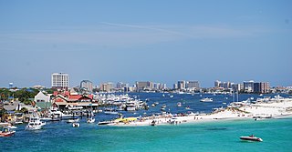
Destin is a city located in Okaloosa County, Florida, United States. It is a principal city of the Crestview–Fort Walton Beach–Destin, Florida Metropolitan Statistical Area. The population was 13,931 at the 2020 census, up from 12,305 at the 2010 census.

Fort Walton Beach, often referred to by the initialism FWB, is a city in southern Okaloosa County, Florida, United States. As of the 2020 U.S. census, the population was 20,922, up from 19,507 in 2010. It is a principal city of the Crestview−Fort Walton Beach−Destin, Florida Metropolitan Statistical Area.

Shalimar is a town in Okaloosa County, Florida, United States. It is part of the Crestview–Fort Walton Beach–Destin, Florida Metropolitan Statistical Area. The population was 737 at the 2020 census, up from 717 at the 2010 census.

The Mendocino National Forest is located in the Coastal Mountain Range in northwestern California and comprises 913,306 acres (3,696.02 km2). It is the only national forest in the state of California without a major paved road entering it. There are a variety of recreational opportunities — camping, hiking, mountain biking, paragliding, backpacking, boating, fishing, hunting, nature study, photography, and off-highway vehicle travel.

Gifford Pinchot National Forest is a National Forest located in southern Washington, managed by the United States Forest Service. With an area of 1.32 million acres (5,300 km2), it extends 116 km (72 mi) along the western slopes of Cascade Range from Mount Rainier National Park to the Columbia River. The forest straddles the crest of the South Cascades of Washington State, spread out over broad old-growth forests, high mountain meadows, several glaciers, and numerous volcanic peaks. The forest's highest point is at 12,276 ft (3,742 m) at the top of Mount Adams, the second-tallest volcano in the state after Rainier. Often found abbreviated GPNF on maps and in texts, it includes the 110,000-acre (450 km2) Mount St. Helens National Volcanic Monument, established by Congress in 1982.

The Florida panhandle is the northwestern part of the U.S. state of Florida. It is a salient roughly 200 miles (320 km) long, bordered by Alabama on the north and the west, Georgia on the north, and the Gulf of Mexico to the south. Its eastern boundary is arbitrarily defined. It is defined by its southern culture and rural geography relative to the rest of Florida, as well as closer cultural links to French-influenced Louisiana, Mississippi, and Alabama. Its major communities include Pensacola, Navarre, Destin, Panama City Beach, and Tallahassee.

The Apalachicola National Forest is the largest U.S. National Forest in the state of Florida. It encompasses 632,890 acres and is the only national forest located in the Florida Panhandle. The National Forest provides water and land-based outdoors activities such as off-road biking, hiking, swimming, boating, hunting, fishing, horse-back riding, and off-road ATV usage.

Lassen National Forest is a United States national forest of 1,700 square miles (4,300 km2) in northeastern California. It is named after pioneer Peter Lassen, who mined, ranched and promoted the area to emigrant parties in the 1850s.

Osceola National Forest is a National Forest located in northeast Florida.

Wenatchee National Forest is a U.S. National Forest located in Washington. With an area of 1,735,394 acres, it extends about 137 miles along the eastern slopes of the Cascade Range of Washington, USA from Okanogan National Forest to Gifford Pinchot National Forest. The forest is located in Chelan, Kittitas and Yakima counties.

Florida's 1st congressional district is a congressional district in the U.S. state of Florida, covering the state's western Panhandle. It includes all of Escambia, Okaloosa, Santa Rosa counties, and portions of Walton county. The district is anchored in Pensacola and also includes the large military bedroom communities and tourist destinations of Navarre and Fort Walton Beach and stretches along the Emerald Coast. The district is currently represented by Republican Matt Gaetz. With a Cook Partisan Voting Index rating of R+19, it is the most Republican district in Florida.

Apalachicola Regional Airport is a county-owned, public-use airport located two nautical miles (4 km) west of the central business district of Apalachicola, a city in Franklin County, Florida, United States. It is included in the National Plan of Integrated Airport Systems for 2011–2015, which categorized it as a general aviation facility. It was previously known as Apalachicola Municipal Airport. The airport supports general aviation activity in the area and provides service via a tenant fixed-base operator (FBO).
The Weeks Act is a federal law enacted by the United States Congress on March 1, 1911. Introduced by Massachusetts Congressman John W. Weeks and signed into law by President William Howard Taft, the law authorized the United States Secretary of Agriculture to "Examine, locate and recommend for purchase ... such lands within the watersheds of navigable streams as ... may be necessary to the regulation of flow of navigable streams...." This meant that the federal government would be able to purchase private land if the purchase was deemed necessary to protect rivers' and watersheds' headwaters in the eastern United States. Furthermore, the law allowed for land acquired through this act to be preserved and maintained as national forest territory. Six years earlier, the Transfer Act of 1905 transferred control over the federal forest reserves from the United States General Land Office of the Department of the Interior to the Department of Agriculture and its Forest Service. Responsibility for land purchased through the Weeks Act was not given to former Chief Forester Gifford Pinchot because he resigned from the National Forest Reservation Commission in 1907, with the stipulation that he would only resign if he could appoint his successor. This stipulation led to the Forest Service's tradition of picking a head with forestry knowledge. With the land acquired through the Weeks Act, Pinchot's successor obtained the power to issue permits for water power development on National Forests. The Weeks Act appropriated $9 million to purchase 6 million acres (24,000 km2) of land in the eastern United States.

The General Revision Act of 1891, also known as the Forest Reserve Act of 1891, was a federal law signed in 1891 by President Benjamin Harrison. The Act reversed previous policy initiatives, such as the Timber Culture Act of 1873, which did not preclude land fraud by wealthy individuals and corporations. The acquisition of vast mineral and timber resources in the Western United States was often cited as a governing motive for such individuals and corporations to claim land rights for future settlement and resource depletion activities. The legacy of the General Revision Act of 1891 is frequently credited as its serving as a catalyst to a series of federal land reform initiatives, notably under President Theodore Roosevelt. From the Reclamation Act of 1902 to the formation of the United States Forest Service in 1905, the General Revision Act of 1891 acted as a critical first piece of federal legislation granting increased plots of publicly allotted land and decreased extraction rights to privately held western land owners in the early 20th century.

The Florida Trail is one of eleven National Scenic Trails in the United States, created by the National Trails System Act of 1968. It runs 1,500 miles (2,400 km), from Big Cypress National Preserve to Fort Pickens at Gulf Islands National Seashore, Pensacola Beach. Also known as the Florida National Scenic Trail, the trail provides permanent non-motorized recreation for hiking and other compatible activities within an hour's drive of most Floridians.
The Camp Pinchot Historic District is a U.S. historic district, located approximately 0.5 miles (0.80 km) north of Fort Walton Beach, Florida. The district is on Eglin Air Force Base, roughly along the west bank of Garnier's Bayou. It contains 10 historic buildings.
The Northwest Florida Water Management District (NWFWMD) stretches from the St. Marks River Basin in Jefferson County to the Perdido River in Escambia County. The District is one of five water management districts in Florida created by the Water Resources Act of 1972. The District has worked for decades to protect and manage water resources in a sustainable manner for the continued welfare of people and natural systems across its 16-county region. It serves Bay, Calhoun, Escambia, Franklin, Gadsden, Gulf, Holmes, Jackson, Leon, Liberty, Okaloosa, Santa Rosa, Wakulla, Walton, Washington and western Jefferson Counties.

The Pensacola and Atlantic Railroad (P&A) was a company incorporated by an act of the Florida Legislature on March 4, 1881, to run from Pensacola to the Apalachicola River near Chattahoochee, a distance of about 160 miles (260 km). No railroad had ever been built across the sparsely populated panhandle of Florida, which left Pensacola isolated from the rest of the state. William D. Chipley and Frederick R. De Funiak, both of whom are commemorated in the names of towns later built along the P&A line, were among the founding officers of the railroad company.


