Lignumvitae Key Botanical State Park is a Florida State Park consisting of Lignumvitae Key, Shell Key, surrounding submerged lands, and a parcel at the northern end of Lower Matecumbe Key. The islands are located one mile west of U.S. 1 (Overseas Highway) at mile marker 78.5, and can be reached only by private boat or tour boat.
The park includes Lignumvitae Key (287 acres [116ha]), Shell Key (203 acres [82ha]), a parcel of (11 acres [4ha]) on Lower Matecumbe Key, three parcels of mangrove forest adjacent to Upper Matecumbe Key and Lower Matecumbe Key, totaling 267 acres (108ha), and 9,958 acres (40km2) of submerged land, primarily on the Florida Bay side of the Matecumbe Keys, but extending between Upper Matecumbe Key and Lower Matecumbe Key into the Atlantic Ocean.[4]
Lignumvitae Key has also been known as Cayo de la Leña (in the Spanish Florida period), Jenkinson Key (during British rule), and Lignurd Vetoz (in the early and middle 19th century), before becoming known by its present name sometime in the late 19th century.[7]
Lignumvitae Key, as part of the upper and middle Florida Keys, is composed of Key Largo Limestone, a fossilized coral reef formed hundreds of thousands of years ago when the sea level was higher than today. The flora on the island is typical of the Bahamas and West Indies, as the result of seeds being brought to the island by wind, water and migrating birds.[8] Shell Key is a mangrove island.[9]
A wealthy chemist from Miami, William John Matheson, bought the island in 1919. He built a small home, with a windmill to supply power and a cistern to capture fresh rainwater. The renovated building is now the visitor center for the park.[8]
The State of Florida acquired Lignumvitae Island in 1971. It has since added several parcels to the park.[1]
Activities
Hour-long guided walks occur twice daily, Friday - Sunday. There is no fishing or swimming allowed off the dock or within 100 feet of it. No more than 50 people are permitted on the Key at one time - 25 on the trail and 25 in the clearing. Visitors are warned to bring shoes and mosquito repellent.
Hours
The park is open from 8:00a.m. till 4:00p.m. daily except Tuesday and Wednesday.
Tours are given only on Friday, Saturday and Sunday at 10am and 2pm December thru April.
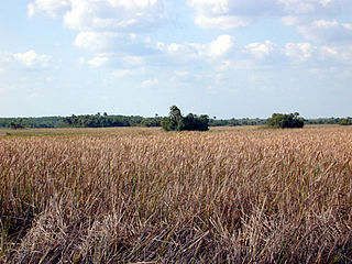
The Everglades is a natural region of flooded grasslands in the southern portion of the U.S. state of Florida, comprising the southern half of a large drainage basin within the Neotropical realm. The system begins near Orlando with the Kissimmee River, which discharges into the vast but shallow Lake Okeechobee. Water leaving the lake in the wet season forms a slow-moving river 60 miles (97 km) wide and over 100 miles (160 km) long, flowing southward across a limestone shelf to Florida Bay at the southern end of the state. The Everglades experiences a wide range of weather patterns, from frequent flooding in the wet season to drought in the dry season. Throughout the 20th century, the Everglades suffered significant loss of habitat and environmental degradation.
Biscayne National Park is a national park of the United States located south of Miami, Florida, in Miami-Dade County. The park preserves Biscayne Bay and its offshore barrier reefs. Ninety-five percent of the park is water, and the shore of the bay is the location of an extensive mangrove forest. The park covers 172,971 acres and includes Elliott Key, the park's largest island and northernmost of the true Florida Keys, formed from fossilized coral reef. The islands farther north in the park are transitional islands of coral and sand. The offshore portion of the park includes the northernmost region of the Florida Reef, one of the largest coral reefs in the world.
Everglades National Park is a national park of the United States that protects the southern twenty percent of the original Everglades in Florida. The park is the largest tropical wilderness in the United States and the largest wilderness of any kind east of the Mississippi River. An average of one million people visit the park each year. Everglades is the third-largest national park in the contiguous United States after Death Valley and Yellowstone. UNESCO declared the Everglades & Dry Tortugas Biosphere Reserve in 1976 and listed the park as a World Heritage Site in 1979, and the Ramsar Convention included the park on its list of Wetlands of International Importance in 1987. Everglades is one of only three locations in the world to appear on all three lists.
The Florida Keys are a coral cay archipelago off the southern coast of Florida, forming the southernmost part of the continental United States. They begin at the southeastern coast of the Florida peninsula, about 15 miles (24 km) south of Miami and extend in an arc south-southwest and then westward to Key West, the westernmost of the inhabited islands, and on to the uninhabited Dry Tortugas. The islands lie along the Florida Straits, dividing the Atlantic Ocean to the east from the Gulf of Mexico to the northwest, and defining one edge of Florida Bay. The southern part of Key West is 93 miles (150 km) from Cuba. The Keys are located between about 24.3 and 25.5 degrees North latitude.
Flamingo Gardens is a 60-acre (24 ha) botanical garden and wildlife sanctuary, located just west of Fort Lauderdale, Florida and north of Miami at 3750 South Flamingo Road, Davie, Florida, United States. It is open to the public for a fee.
The Key Largo woodrat, a subspecies of the eastern woodrat, is a medium-sized rat found on less than 2,000 acres of the northern area of Key Largo, Florida, in the United States. It is currently on the United States Fish and Wildlife Service list of endangered species. Only 6500 animals were thought to remain in North Key Largo in the late 1980s.
Hammock is a term used in the southeastern United States for stands of trees, usually hardwood, that form an ecological island in a contrasting ecosystem. Hammocks grow on elevated areas, often just a few inches high, surrounded by wetlands that are too wet to support them. The term hammock is also applied to stands of hardwood trees growing on slopes between wetlands and drier uplands supporting a mixed or coniferous forest. Types of hammocks found in the United States include tropical hardwood hammocks, temperate hardwood hammocks, and maritime or coastal hammocks. Hammocks are also often classified as hydric, mesic or xeric. The types are not exclusive, but often grade into each other.
The Crocodile Lake National Wildlife Refuge is part of the United States National Wildlife Refuge System, located in north Key Largo, less than 40 miles (64 km) south of Miami off SR 905. The 6,686 acres (2,706 ha) refuge opened during the year of 1980, under the Land and Water Conservation Fund Act of 1965 and the Endangered Species Act of 1973. It was established in order to protect critical breeding and nesting habitat for the threatened American crocodile and other wildlife. This area also includes 650 acres (260 ha) of open water in and around the refuge. In addition to being one of only three breeding populations of the American crocodile, the refuge is home to tropical hardwood hammock, mangrove forest, and salt marsh. It is administered as part of the National Key Deer Refuge which is also located in the Florida Keys.
Lignumvitae Key is an island in the upper Florida Keys.
Pinecrest Gardens is a 20-acre (81,000 m2) park in Pinecrest, Florida on the corner of Southwest 111th Street and Southwest 57th Avenue.
The Weedon Island Preserve is a 3,190-acre natural area situated along the western shore of Tampa Bay and located at 1800 Weedon Drive NE, St. Petersburg, Florida, United States. It is predominately an estuarine preserve composed of upland and aquatic ecosystems such as mangrove forests, pine/scrubby flatwoods, and maritime hammocks, and is home to a variety of native wildlife. The preserve is also a designated archaeological area, with several shell mounds identified on the property that provide evidence of early peoples who inhabited the land for thousands of years.
In 1999, the Guana Tolomato Matanzas National Estuarine Research Reserve was designated in St. Johns and Flagler counties, Florida as a part of the National Oceanic and Atmospheric Administration (NOAA) National Estuarine Research Reserve (NERR) system. The GTM Research Reserve represents the east Florida sub-region of the Carolinian bioregion. It is one of 30 NERRs in 23 states and one territory. GTM is one of three NERRs in Florida and is administered on behalf of the state by the Florida Department of Environmental Protection's Florida Coastal Office as part of a network that includes forty-one aquatic preserves, three NERRs, a National Marine Sanctuary, the Coral Reef Conservation Program and the Florida Oceans and Coastal Council. Additional interests are held in the research and management of the GTM and connected preserved or conserved lands including:
Crane Point Museum and Nature Center is a nonprofit natural history museum and nature center located in the City of Marathon on Key Vaca, in the heart of the Florida Keys in Monroe County, Florida, United States.
Before drainage, the Everglades, a region of tropical wetlands in southern Florida, were an interwoven mesh of marshes and prairies covering 4,000 square miles (10,000 km2). The Everglades is both a vast watershed that has historically extended from Lake Okeechobee 100 miles (160 km) south to Florida Bay, and many interconnected ecosystems within a geographic boundary. It is such a unique meeting of water, land, and climate that the use of either singular or plural to refer to the Everglades is appropriate. When Marjory Stoneman Douglas wrote her definitive description of the region in 1947, she used the metaphor "River of Grass" to explain the blending of water and plant life.
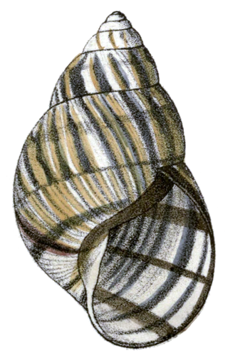
Orthalicus reses, the Stock Island tree snail or the Florida tree snail, is a species of large tropical air-breathing tree snail, a terrestrial pulmonate gastropod mollusk in the family Orthalicidae. It was first described in 1830 by the American naturalist Thomas Say. The holotype, a specimen probably collected in Key West, was subsequently lost. Over a hundred years later, in 1946, the American biologist Henry Augustus Pilsbry redescribed the species using a specimen from Stock Island, Florida. Orthalicus reses has two subspecies, O. reses reses and O. reses nosodryas. The validity of these two taxa is still being discussed, but some experts argue that considering them as independent units may be important for management purposes.
Papilio aristodemus, the Schaus' swallowtail or island swallowtail, is a species of American butterfly in the family Papilionidae. It is found in southern Florida in the United States and throughout the West Indies. It is named in honor of William Schaus.
Tropical hardwood hammocks are closed canopy forests, dominated by a diverse assemblage of evergreen and semi-deciduous tree and shrub species, mostly of West Indian origin. Tropical hardwood hammocks are found in South Florida or the Everglades, with large concentrations on the Miami Rock Ridge, in the Florida Keys, along the northern shores of Florida Bay, and in the Pinecrest region of the Big Cypress Swamp.
The South Florida rocklands ecoregion, in the tropical and subtropical moist broadleaf forests biome, occurs in southern Florida and the Florida Keys in the United States, where they would naturally cover an area of 2,100 km2 (810 sq mi). These forests form on limestone outcrops with very thin soil; the higher elevation separating them from other habitats such as coastal marshes and marl prairies. On mainland Florida, rocklands exist primarily on the Miami Rock Ridge, which extends from the Miami River south to Everglades National Park. South Florida rocklands are further divided into pine rocklands and rockland hammocks.
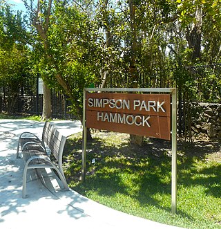
Simpson Park, officially Simpson Park Hammock, is a 7.8-acre (3.2 ha) urban park and nature preserve located between Brickell and The Roads neighborhoods of Miami, Florida. The park was originally known as Jungle Park, as 5.5 acres (2.2 ha) were set aside in 1913 by a group of individuals to preserve what is now one of the last remaining tracts of Brickell Hammock, a tropical hardwood hammock which once ran from the Miami River to Coconut Grove.
This page is based on this Wikipedia article Text is available under the CC BY-SA 4.0 license; additional terms may apply. Images, videos and audio are available under their respective licenses.