Pedro Menéndez de Avilés was a Spanish admiral, explorer and conquistador from Avilés, in Asturias, Spain. He is notable for planning the first regular trans-oceanic convoys, which became known as the Spanish treasure fleet, and for founding St. Augustine, Florida, in 1565. This was the first successful European settlement in La Florida and the most significant city in the region for nearly three centuries.
Bahamian Americans are an ethnic group of Caribbean Americans of Bahamian ancestry. There are an estimated 56,797 people of Bahamian ancestry living in the US as of 2019.
Conch was originally a slang term for Bahamians of European descent.

No Name Key is an island in the lower Florida Keys in the United States. It is 3 miles (4.8 km) from US 1 and sparsely populated, with only 43 homes. It is only about 1,140 acres in comparison to its larger neighbor, Big Pine Key, which lies about half a mile (800 m) to its west. It is accessible by a concrete bridge from Big Pine Key and was the terminus of a car ferry that existed before the present Overseas Highway was built on the remains of Flagler's Overseas Railroad.

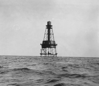
Carysfort Reef Light is located east of Key Largo, Florida. The lighthouse has an iron-pile foundation with a platform, and a skeletal, octagonal, pyramidal tower, which is painted red. The light was 100 feet (30 m) above the water. It was the oldest functioning lighthouse of its type in the United States until it was decommissioned in 2015, having been completed in 1852. The light last installed was a xenon flashtube beacon. It was added to the National Register of Historic Places in 1984.
Anastasia Island is a barrier island located off the northeast Atlantic coast of Florida in the United States. It sits east of St. Augustine, running north–south in a slightly southeastern direction to Matanzas Inlet. The island is about 14 miles (23 km) long and an average of 1 mile in width. It is separated from the mainland by the Matanzas River, part of the Intracoastal waterway. Matanzas Bay, the body of water between the island and downtown St. Augustine, opens into St. Augustine Inlet.

Henry Perrine was a physician, horticulturist, United States Consul in Campeche, Campeche, Mexico, and an enthusiast for introducing tropical plants into cultivation in the United States.

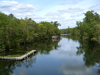
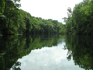
The St. Marks River is a river in the Big Bend region of Florida. It has been classified by the Florida Department of Environmental Protection as an Outstanding Florida Water, and is the easternmost river within the Northwest Florida Water Management District.

Crandon Park is an 808-acre (3.27 km2) urban park in metropolitan Miami, occupying the northern part of Key Biscayne. It is connected to mainland Miami via the Rickenbacker Causeway.

The Wakulla River is an 11-mile-long (18 km) river in Wakulla County, Florida. It carries the outflow from Wakulla Springs, site of the Edward Ball Wakulla Springs State Park, to the St. Marks River 3 miles (5 km) north of the Gulf of Mexico. Its drainage basin extends northwest into Leon County, including Munson Slough, and may extend as far north as the Georgia border.

The Dr. Malcolm Nicholson Farmhouse is a historic farmhouse in Havana, Florida, United States. It is located at 200 Coca-Cola Avenue, on SR 12 west of Havana. On October 28, 1994, it was added to the U.S. National Register of Historic Places.

The Sopchoppy River is a minor river in the Florida Big Bend. A tributary of the Ochlockonee River, it is approximately 46 miles (74 km) in length and nearly entirely within Wakulla County, with only a small part of its East Branch entering Leon County.

The Clapp Octagon House is an historic octagonal house located at 62 Lighthouse Avenue in the historic Lighthouse Park neighborhood on the north end of Anastasia Island in St. Augustine, Florida. It was built in 1886 for Rollin N. Clapp of St. Louis, Missouri.

The Haig Point Range Lights were range lights on Calibogue Sound at the northeastern end of Daufuskie Island in Beaufort County, South Carolina. The Haig Point Range Lights were built in 1873 and were maintained as an official aid to navigation until about 1924. The Rear Range Light house has been restored. It is a guest house for the Haig Point Club and serves as a private aid to navigation.
The Bloody Point Range Lights, which is known as the Bloody Point Lighthouse, were range lights on the southern end of Daufuskie Island in Beaufort County, South Carolina. The Bloody Point Range Lights were built in 1883. Due to erosion, the front light was moved to the location of the former rear light and became the rear light. The lights were maintained as an official aid to navigation until 1922. The original Front Range Light house is currently a private home.

The Harbour Town Lighthouse is a lighthouse at the Harbour Town Marina at Hilton Head Island, South Carolina. It was privately built and is a private aid to navigation. Although initially ridiculed by local residents during the planning and construction phases, the lighthouse became instantly popular and is today the most recognizable symbol of Hilton Head Island and Sea Pines Resort. The annually televised Heritage golf tournament has helped increase the lighthouse's fame to millions of golf fans worldwide, and the 18th hole at the Harbour Town Golf Links has become one of the most popular and recognizable finishing holes in golf.

Indian Key was an unincorporated community in Monroe County and, for a while, Dade County, Florida, United States. It was located in the upper Florida Keys on the island of Indian Key and is currently a ghost town.

The Florida Reef is the only living coral barrier reef in the continental United States. It lies a few miles seaward of the Florida Keys, is about 4 miles wide and extends 270 km (170 mi) from Fowey Rocks just east of Soldier Key to just south of the Marquesas Keys. The system encompasses more than 6,000 individual reefs. Florida waters are home to over 500 marine fish and mammal species along with more than 45 species of stony corals and 35 species of octocorals.
Carysfort is a coral reef located within the Florida Keys National Marine Sanctuary. It lies to the east of Key Largo, within the Key Largo Existing Management Area, which is immediately to the east of John Pennekamp Coral Reef State Park. This reef is within a Sanctuary Preservation Area (SPA). The reef is northeast of The Elbow. The Carysfort Reef Light is near the center of the SPA.
St. Augustine, Florida, the oldest continuously occupied settlement of European origin in the continental United States, was founded in 1565 by Spanish admiral Pedro Menéndez de Avilés. The Spanish Crown issued an asiento to Menéndez, signed by King Philip II on March 20, 1565, granting him various titles, including that of adelantado of Florida, and expansive privileges to exploit the lands in the vast territory of Spanish Florida, called La Florida by the Spaniards. This contract directed Menéndez to explore the region's Atlantic coast and report on its features, with the object of finding a suitable location to establish a permanent colony from which the Spanish treasure fleet could be defended and Spain's claimed territories in North America protected against incursions by other European powers.


