Indian Harbour Beach is a coastal city in Brevard County, Florida, United States. It is part of the Palm Bay–Melbourne–Titusville, Florida Metropolitan Statistical Area. The population was 9,019 at the 2020 census, up from 8,225 at the 2010 census.

Satellite Beach is a coastal city in Brevard County, Florida, U.S. The population was 11,226 at the 2020 United States Census, up from 10,109 at the 2010 census, and it is located with the Atlantic Ocean to the east and the Banana River to the west. Satellite Beach is part of the Palm Bay–Melbourne–Titusville, Florida Metropolitan Statistical Area.

Ormond-by-the-Sea is a census-designated place and an unincorporated town in Volusia County, Florida, United States. The population was 7,312 as of the 2020 census, a decrease from 7,406 in the 2010 census.

Myakka River State Park is a Florida State Park, that is located nine miles (14 km) east of Interstate 75 in Sarasota County and a portion of southeastern Manatee County on the Atlantic coastal plain. This state park consists of 37,000 acres (150 km2), making it one of the state's largest parks. It is also one of the oldest parks in the state. It was delineated in the 1930s by the Civilian Conservation Corps. A small portion of the park was the gift of the family of Bertha Palmer to the state. The park is named after the Myakka River.

The Arboretum of the University of Central Florida is located on the main campus of the University of Central Florida in Orlando, Florida, United States. Covering 80 acres (320,000 m2), it contains more than 600 species of plants, including more than 100 bromeliads, in cultivated gardens.

Perdido Key is an unincorporated community located in Escambia County, Florida, United States, between the cities of Pensacola, Florida and Orange Beach, Alabama. The community is located on and named for Perdido Key, a barrier island in northwest Florida and southeast Alabama. "Perdido" means "lost" in the Spanish and Portuguese languages. The Florida district of the Gulf Islands National Seashore includes the east end of the island, as well as other Florida islands. No more than a few hundred yards wide in most places, Perdido Key stretches some 16 miles (26 km) from near Pensacola to Perdido Pass Bridge near Orange Beach.

Amelia Island State Recreation Area is a state park in Florida, United States. Its location is 7 miles (11 km) north of Little Talbot Island State Park on SR A1A, and 8 miles (13 km) south of Fernandina Beach on Amelia Island along the Atlantic coastal plain. This park consists of 200 acres (0.81 km2) of beaches, salt marshes and coastal maritime forests.

Little Talbot Island State Park is a Florida State Park located on Little Talbot Island, 17 miles (27 km) northeast of Jacksonville on State Road A1A. The park covers the entire 2,500-acre (10 km2) island. Big Talbot Island State Park lies to the immediate north. The park contains maritime forests, dunes, and salt marshes on the western side of the island. Wild life includes river otters, marsh rabbits, bobcats, and a variety of native and migrating birds. Activities include camping, fishing, hiking, swimming, canoeing, nature watching and surfing. Erosion on Big Talbot Island, coupled with sand deposition on Little Talbot, have resulted in Little Talbot Island becoming the larger of the two Talbot Islands. The largest continuous section of the Machaba Balu Preserve lies just to the west of Little Talbot Island.

Fort Pierce Inlet State Park, a 340-acre (1.4 km2) part of the Florida State Park system, is located just north of the Fort Pierce Inlet, on North Hutchinson Island, near Fort Pierce. It consists of beaches, dunes and a coastal hammock between the Atlantic Ocean and the waters of Tucker Cove, an indentation of the Indian River Lagoon.

Gamble Rogers Memorial State Recreation Area is a 144-acre (0.58 km2) Florida State Park in Flagler Beach, Florida, United States, between the Atlantic Ocean and the Intra-Coastal Waterway on State Route A1A. It is about 18 miles (29 km) north of Daytona Beach and about 30 miles (48 km) south of St. Augustine.

Washington Oaks Gardens State Park is a Florida State Park located near Palm Coast, Florida, along A1A. The park is made up of 425 acres and is most famous for its formal gardens, but it also preserves the original habitat of a northeast Florida barrier island.
Hammock is a term used in the southeastern United States for stands of trees, usually hardwood, that form an ecological island in a contrasting ecosystem. Hammocks grow on elevated areas, often just a few inches high, surrounded by wetlands that are too wet to support them. The term hammock is also applied to stands of hardwood trees growing on slopes between wetlands and drier uplands supporting a mixed or coniferous forest. Types of hammocks found in the United States include tropical hardwood hammocks, temperate hardwood hammocks, and maritime or coastal hammocks. Hammocks are also often classified as hydric, mesic or xeric. The types are not exclusive, but often grade into each other.

The Florida Trail is one of eleven National Scenic Trails in the United States, created by the National Trails System Act of 1968. It runs 1,500 miles (2,400 km), from Big Cypress National Preserve to Fort Pickens at Gulf Islands National Seashore, Pensacola Beach. Also known as the Florida National Scenic Trail, the trail provides permanent non-motorized recreation for hiking and other compatible activities within an hour of most floridians.
Great Florida Birding and Wildlife Trail (GFBWT) is a 2,000 mile (3200 km) long collection of more than 500 locations in the U.S. state of Florida where the state's bird habitats are protected. The trail promotes birdwatching, environmental education and ecotourism. The GFBWT is a program of the Florida Fish and Wildlife Conservation Commission, supported in part by the Florida Department of Transportation and the Wildlife Foundation of Florida. It is modeled after the successful Great Texas Coastal Birding Trail. Trail sites area identifiable by prominent road signs bearing the Swallow-tailed kite logo.

In 1999, the Guana Tolomato Matanzas National Estuarine Research Reserve was designated in St. Johns and Flagler counties, Florida as a part of the National Oceanic and Atmospheric Administration (NOAA) National Estuarine Research Reserve (NERR) system. The GTM Research Reserve represents the east Florida sub-region of the Carolinian bioregion. It is one of 30 NERRs in 23 states and one territory. GTM is one of three NERRs in Florida and is administered on behalf of the state by the Florida Department of Environmental Protection's Florida Coastal Office as part of a network that includes forty-one aquatic preserves, three NERRs, a National Marine Sanctuary, the Coral Reef Conservation Program and the Florida Oceans and Coastal Council. Additional interests are held in the research and management of the GTM and connected preserved or conserved lands including:

Florida scrub is a forest ecoregion found throughout Florida in the United States. It is found on coastal and inland sand ridges and is characterized by an evergreen xeromorphic plant community dominated by shrubs and dwarf oaks. Because the low-nutrient sandy soils do not retain moisture, the ecosystem is effectively an arid one. Wildfires infrequently occur in the Florida scrub. Most of the annual rainfall falls in summer.

The Southeastern conifer forests are a temperate coniferous forest ecoregion of the southeastern United States. It is the largest conifer forest ecoregion east of the Mississippi River. It is also the southernmost instance of temperate coniferous forest within the Nearctic realm.

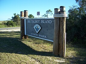
Boneyard Beach is a mile-long beach in Big Talbot Island State Park, near the city of Fernandina Beach, Florida, south of Amelia Island down the First Coast Highway. The "boneyard beach" is so called because of the bleached skeletons of oaks along the beach. By coincidence park archaeologists have also found fossilized mammoth bones on the beach nearly as big as the trees. Big Talbot's Boneyard Beach is not recommended for swimming but is popular with photographers. The beach lies beyond a 20-foot bluff.
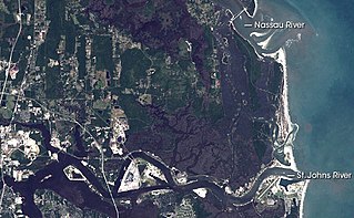
The Machaba Balu Preserve is a nature preserve encompassing 10,000 acres (4,000 ha) of protected lands in northeastern Florida, just to the northeast of Jacksonville, at the confluence of the Nassau, the St. Marys, and the St. Johns Rivers as they flow toward the Atlantic Ocean through a wide network of islands, canals, and tidal marshes. The name Machaba Balu means "saved marsh" in the language of the Timucua people, who occupied the area in pre-Columbian times and met the first European explorers of the region; the Timucua never used this name themselves, however, as it is a modern language construct. The preserve, created with land purchased in 2002 mostly from Alcoma Corporation by the Nature Conservancy, includes 77 islands and numerous individual tracts of tidal marshland between the Nassau and the St. Johns Rivers. The largest clusters lie to the west of Little Talbot Island State Park and on either side of Sisters Creek south of the large fork.

The North American Southern Coastal Plain is a Level III ecoregion designated by the Environmental Protection Agency (EPA) in six U.S. states. The region stretches across the Gulf coast from eastern Louisiana to Florida, forms the majority of Florida, and forms the coastlines of Georgia and much of South Carolina. It has been divided into twelve Level IV ecoregions.