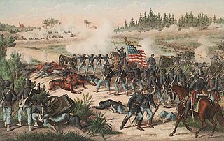
The Battle of Olustee or Battle of Ocean Pond was fought in Baker County, Florida on February 20, 1864, during the American Civil War. It was the largest battle fought in Florida during the war.
Natural bridge or Natural Bridge may refer to:

The Battle of Natural Bridge was fought during the American Civil War in what is now Woodville, Florida near Tallahassee on March 6, 1865. A small group of Confederate troops and volunteers, which included teenagers from the nearby Florida Military and Collegiate Institute that would later become Florida State University, protected by breastworks, prevented a detachment of United States Colored Troops from crossing the Natural Bridge on the St. Marks River.

Poison Springs Battleground State Park is an Arkansas state park located southeast of Bluff City. It commemorates the Battle of Poison Spring in the American Civil War, which was part of the 1864 Camden Expedition, an element of a Union Army initiative to gain control of Shreveport, Louisiana and get a foothold in Texas.

San Marcos de Apalache Historic State Park is a Florida State Park in Wakulla County, Florida organized around the historic site of a Spanish colonial fort, which was used by succeeding nations that controlled the area. The Spanish first built wooden buildings and a stockade in the late 17th and early 18th centuries here, which were destroyed by a hurricane.

The Battle of Hatchie's Bridge, also known as Battle of Davis Bridge or Matamora, was fought on October 5, 1862, in Hardeman County and McNairy County, Tennessee, as the final engagement of the Iuka–Corinth Campaign of the American Civil War. Confederate Major General Earl Van Dorn's army successfully evaded capture by the Union Army, following his defeat at the Battle of Corinth.

The American Battlefield Trust is a charitable organization whose primary focus is in the preservation of battlefields of the Revolutionary War, the War of 1812, and the American Civil War, through the acquisition of battlefield land. The American Battlefield Trust was formerly known as the Civil War Trust. On May 8, 2018, the organization announced the creation of the American Battlefield Trust as the umbrella organization for two divisions, the Civil War Trust and the Revolutionary War Trust, which was formerly known as "Campaign 1776".
Antietam National Battlefield is a National Park Service-protected area along Antietam Creek in Sharpsburg, Washington County, northwestern Maryland. It commemorates the American Civil War Battle of Antietam that occurred on September 17, 1862.
Wilson's Creek National Battlefield, located near Republic, Missouri, preserves the site of the Battle of Wilson's Creek. Fought on August 10, 1861, the battle was the first major American Civil War engagement west of the Mississippi River. In the battle, a Confederate army commanded by Benjamin McCulloch and Sterling Price defeated a smaller Union army commanded by Nathaniel Lyon. However, the Confederates were unable to hold much of Missouri, and a Confederate defeat at the Battle of Pea Ridge effectively solidified Union control of the state. Major features include a five-mile automobile tour loop, the restored 1852 Ray House, and "Bloody Hill", the site of the final stage of the battle. The site is located near Republic in southwestern Missouri just southwest of the city of Springfield. It has been a unit of the National Park Service since 1960, and was listed on the National Register of Historic Places in 1966.
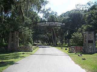
Dade Battlefield Historic State Park is a state park located on County Road 603 between Interstate 75 and U.S. Route 301 in Sumter County, Florida. The 80-acre (32 ha) park includes 40 acres (160,000 m2) of pine flatwoods and a live oak hammock. Also called the Dade Massacre site, it preserves the Second Seminole War battlefield where tribal Seminole warriors and Black Seminole allies fought soldiers under the command of Major Francis L. Dade on December 28, 1835. Each year, on the weekend after Christmas, the Dade Battlefield Society sponsors a reenactment of the battle that started the Second Seminole War.
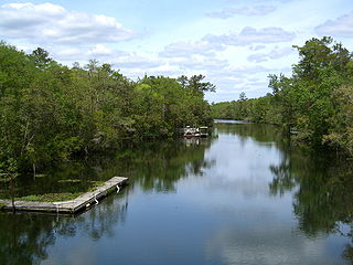
The St. Marks River is a river in the Big Bend region of Florida. It has been classified by the Florida Department of Environmental Protection as an Outstanding Florida Water, and is the easternmost river within the Northwest Florida Water Management District.

America's 11 Most Endangered Places or America's 11 Most Endangered Historic Places is a list of places in the United States that the National Trust for Historic Preservation considers the most endangered. It aims to inspire Americans to preserve examples of architectural and cultural heritage that could be "relegated to the dustbins of history" without intervention.

Sackets Harbor Battlefield State Historic Site is a historically important location in Jefferson County, New York, United States. The historic site is south of the Village of Sackets Harbor, bordering Lake Ontario in the Town of Hounsfield. Two battles were fought near this location during the War of 1812. Some 3,000 men worked at the shipyard building warships, and the village was fortified and garrisoned with thousands of troops.

The Okeechobee Battlefield is a U.S. National Historic Landmark. It is located four miles (6 km) southeast of Okeechobee, on US 441/98, near Taylor Creek. The Battle of Lake Okeechobee, one of the major conflicts of the Second Seminole War, was fought at the site. Part of the battlefield is preserved as Okeechobee Battlefield State Historic Park.

The Big Bend of Florida, United States, is an informally named geographic region of North Florida where the Florida Panhandle transitions to the Florida Peninsula south and east of Tallahassee. The region is known for its vast woodlands and marshlands and its low population density relative to much of the state. The area is home to the largest single spring in the United States, the Alapaha Rise, and the longest surveyed underwater cave in the United States, the 32-mile (51 km) Wakulla-Leon Sinks cave system.

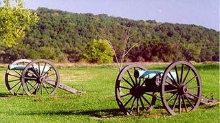
Perryville Battlefield State Historic Site is a 745-acre (3.01 km2) park near Perryville, Kentucky. The park continues to expand with purchases of parcels by the Office of Kentucky Nature Preserves' Kentucky Heritage Land Conservation Fund and the American Battlefield Trust. An interpretive museum is located near the site where many Confederate soldiers killed in the Battle of Perryville were buried. Monuments, interpretive signage, and cannons also mark notable events during the battle. The site became part of the Kentucky State Park System in 1936.

Bentonville Battlefield, also known as the Bentonville Battlefield State Historic Site, is an American Civil War battlefield in Johnston County, North Carolina. It was the site of the 1865 battle of Bentonville, fought in the waning days of the Civil War. The site was declared a National Historic Landmark in 1996.

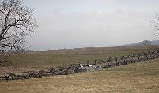
Sayler's Creek Battlefield, near Farmville, Virginia, was the site of the Battle of Sayler's Creek of the American Civil War. Confederate general Robert E. Lee's army was retreating from the Richmond to the Petersburg line. Here, on April 6, 1865, Union general Philip Sheridan cut off and beat back about a quarter of Lee's depleted army. Eight Confederate generals surrendered, and 7,700 men were lost. Confederate Major General George Washington Custis Lee, eldest son of Robert E. Lee, was forcibly captured on the battlefield by Private David Dunnels White of the 37th Massachusetts Regiment. The battle was the last major engagement of the war in Virginia; Lee's surrender at Appomattox occurred three days later. A portion of the landmarked battlefield area is included in Sailor's Creek Battlefield Historical State Park. The Civil War Trust and its partners have acquired and preserved 885 acres (3.58 km2) of the battlefield in five transactions since 1996.

Fort Davidson, a fortification near the town of Pilot Knob, Missouri, was the site of the Battle of Fort Davidson during the American Civil War. Built by Union Army soldiers during the American Civil War, the fort repulsed Confederate attacks during the Battle of Fort Davidson on September 27, 1864, during Price's Raid. That night, the Union garrison blew up the fort's magazine and abandoned the site. A mass grave was constructed on the site to bury battlefield dead. After the war, the area was used by a mining company, before passing into private hands and eventually the administration of the United States Forest Service. In 1968, the Battle of Pilot Knob State Historic Site was created as a Missouri State Park. The fort itself was added to the National Register of Historic Places in 1970. As of 2020, a visitors center containing a museum is located within the park. The museum contains a fiber optic display, as well as artifacts including Brigadier General Thomas Ewing Jr.'s sword. The fort's walls are still visible, as is the crater created when the magazine was detonated. A monument marks the location of the mass grave.
The Civil War Trust's Civil War Discovery Trail is a heritage tourism program that links more than 600 U.S. Civil War sites in more than 30 states. The program is one of the White House Millennium Council's sixteen flagship National Millennium Trails. Sites on the trail include battlefields, museums, historic sites, forts and cemeteries.


