Biscayne National Park is an American national park located south of Miami, Florida in Miami-Dade County. The park preserves Biscayne Bay and its offshore barrier reefs. Ninety-five percent of the park is water, and the shore of the bay is the location of an extensive mangrove forest. The park covers 172,971 acres and includes Elliott Key, the park's largest island and northernmost of the true Florida Keys, formed from fossilized coral reef. The islands farther north in the park are transitional islands of coral and sand. The offshore portion of the park includes the northernmost region of the Florida Reef, one of the largest coral reefs in the world.

Flamingo is the southernmost headquarters of Everglades National Park, in Monroe County, Florida, United States. Flamingo is one of the two end points of the 99-mile (159-km) Wilderness Waterway, and the southern end of the only road through the park from Florida City. It began as a small coastal settlement on the eastern end of Cape Sable on the southern tip of the Florida peninsula, facing Florida Bay. The actual town of Flamingo was located approximately 4+1⁄2 miles west of the current Flamingo campground area. All that remains of the former town are a few remnants of building foundations, and it is considered a ghost town.

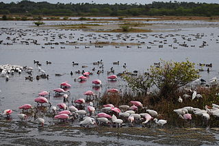
Everglades National Park is an American national park that protects the southern twenty percent of the original Everglades in Florida. The park is the largest tropical wilderness in the United States and the largest wilderness of any kind east of the Mississippi River. An average of one million people visit the park each year. Everglades is the third-largest national park in the contiguous United States after Death Valley and Yellowstone. UNESCO declared the Everglades & Dry Tortugas Biosphere Reserve in 1976 and listed the park as a World Heritage Site in 1979, and the Ramsar Convention included the park on its list of Wetlands of International Importance in 1987. Everglades is one of only three locations in the world to appear on all three lists.
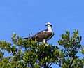
Pelican Island National Wildlife Refuge is a United States National Wildlife Refuge (NWR), and part of the Everglades Headwaters NWR complex, located just off the western coast of North Hutchinson Island in the Indian River Lagoon east of Sebastian, Florida. The refuge consists of a 3-acre (12,000 m2) island that includes an additional 2.5 acres (10,000 m2) of surrounding water and is located off the east coast of Florida of the Indian River Lagoon. Established by an executive order of President Theodore Roosevelt on March 14, 1903, Pelican Island was the first National wildlife refuge in the United States. It was created to protect egrets and other birds from extinction through plume hunting.
Merritt Island National Wildlife Refuge is a 140,000 acres (57,000 ha) U.S. National Wildlife Refuge (NWR) on the Atlantic coast of Florida's largest barrier island. NASA's Kennedy Space Center and visitor complex are also situated on the island and NASA can restrict access to the refuge based on its operational needs.
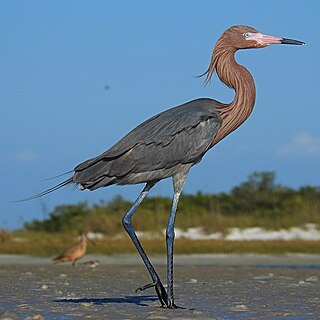
The reddish egret is a medium-sized heron. It is a resident breeder in Central America, The Bahamas, the Caribbean, the Gulf Coast of the United States, and Mexico. There is post-breeding dispersal to well north of the nesting range. In the past, this bird was a victim of the plume trade.

Goose Creek State Park is a North Carolina state park near Washington, Beaufort County, North Carolina in the United States. It covers 1,672 acres (6.77 km2) just off of Pamlico Sound, in North Carolina's Coastal Plain. Goose Creek State Park is home to a wide variety of wildlife that make their homes in the extensive salt water marshes, inlets and creeks on the northern side of the sound. Goose Creek State Park is open for year-round recreation, east of Washington, two miles (3 km) south of U.S. Route 264 on Camp Leach Road.

The Folsom Lake State Recreation Area surrounds Folsom Lake in the foothills of the Sierra Nevada, and is managed by the California Department of Parks and Recreation. It is located near the city of Folsom, California, about 25 miles (40 km) east of Sacramento.

The New River Gorge National Park and Preserve is a unit of the United States National Park Service (NPS) designed to protect and maintain the New River Gorge in southern West Virginia in the Appalachian Mountains. Established in 1978 as a national river and redesignated in 2020, the park and preserve stretches for 53 miles (85 km) from just downstream of Hinton to Hawks Nest State Park near Ansted. The park is rich in cultural and natural history, and offers an abundance of scenic and recreational opportunities. New River Gorge is home to some of the country's best whitewater rafting, mainly from the Cunard put-in to the Fayette Station take-out, and is also one of the most popular climbing areas on the East Coast. The New River itself originates in North Carolina, flowing north through Virginia into the West Virginia mountains to the Kanawha River which continues to the Ohio River.

South-southwest of St. Petersburg, Florida, Fort De Soto Park is a park operated by Pinellas County on five offshore keys, or islands: Madelaine Key, St. Jean Key, St. Christopher Key, Bonne Fortune Key and the main island, Mullet Key. The keys are connected by either bridge or causeway. The island group is accessible by toll road from the mainland. Historically, the islands were used for military fortifications; remnants and a museum exhibit this history. Two piers, beaches, picnic area, hiking trails, bicycling trails, kayak trail, and a ferry to Egmont Key State Park are available.

Perdido Key is an unincorporated community in Escambia County, Florida, United States, between Pensacola, Florida and Orange Beach, Alabama. "Perdido" means "lost" in the Spanish and Portuguese languages. The community is located on and named for Perdido Key, a barrier island in northwest Florida and southeast Alabama. The Florida district of the Gulf Islands National Seashore includes the east end of the island, as well as other Florida islands. No more than a few hundred yards wide in most places, Perdido Key stretches some 16 miles (26 km) from near Pensacola to Perdido Pass Bridge near Orange Beach.

Oscar Scherer State Park is a Florida State Park located between Sarasota and Venice, near Osprey. The address is 1843 South Tamiami Trail. There are more than 250,000 visitors a year.

Cayo Costa State Park is a state park in the U.S. state of Florida, on Cayo Costa, an island directly south of Boca Grande and just north of North Captiva Island, approximately 12 miles (19 km) west of Cape Coral. The park is accessible only by charter boat, private boat, ferry or helicopter.

Faver-Dykes State Park is a Florida State Park located 15 miles south of St. Augustine, near the intersection of I-95 and US 1, and bordering Pellicer Creek, a designated state canoe trail. Activities include fishing, picnicking, boating, canoeing, camping and wildlife viewing.

Lovers Key State Park is a 712-acre (2.88 km2) Florida State Park located on Lover's Key and three other barrier islands—Black Island, Inner and Long Key. It is at 8700 Estero Blvd., Fort Myers Beach, between Big Carlos Pass and New Pass and 10.5 miles (16.9 km) west of Interstate 75 on exit 116. The park lies within the city limits of Bonita Springs and is just north of Bonita Beach. The park uses a Fort Myers Beach zip code for address purposes.

Werner-Boyce Salt Springs State Park is a Florida state park located in Pasco County, Florida near Port Richey, Florida, along the Gulf of Mexico on the Atlantic coastal plain. An entrance to this park is at the intersection of Scenic Drive and Cinema Drive, one mile west of the intersection of Cinema Drive/Ridge Manor Blvd. and U.S. Highway 19. The park is named, in part, for a 320 feet deep saltwater spring in the park, which is not yet easily accessible. The park includes four miles of Pasco County's coastal waters on the Gulf of Mexico.

Manatee Springs State Park is a Florida State Park located six miles west of Chiefland on SR 320, off US 19. Manatee Spring is a first magnitude spring that flows directly into the Suwannee River by way of a short run. Present also are swamps and hardwood wetlands along the Suwannee, along with many sinkhole ponds, including one with a cave 90 feet below the ground that connects to a popular divers' destination known as the catfish hotel.
Lake Perris is an artificial lake completed in 1973. It is the southern terminus of the California State Water Project, situated in a mountain-rimmed valley between Moreno Valley and Perris, in what is now the Lake Perris State Recreation Area. The park offers a variety of recreational activities. Because of this and the lake's proximity to major population centers, it is very crowded during the summer months.
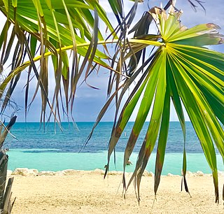
Bahia Honda is an island in the lower Florida Keys.

Matia Island is an island in the San Juan Islands of the U.S. state of Washington. The island's entire 145 acres (59 ha) comes under the protection of the U.S. Fish and Wildlife Service and is cooperatively managed by the Washington State Parks and Recreation Commission as Matia Island Marine State Park. Matia Island is a National Wildlife Refuge, part of the San Juan Islands National Wildlife Refuge. A 2-acre (0.81 ha) camping area around Rolfe Cove is managed as a State Marine Park by the Washington State Parks and Recreation Commission under an agreement dating back to 1959. Pets, wood collecting, and campfires are not allowed on the island. Except for the Wilderness Loop Trail and the campground, all areas above the high tide line are closed to the public.