
The Muscogee, also known as the Mvskoke, Muscogee Creek or just Creek, and the Muscogee Creek Confederacy, are a group of related Indigenous peoples of the Southeastern Woodlands in the United States. Their historical homelands are in what now comprises southern Tennessee, much of Alabama, western Georgia and parts of northern Florida.

Hardee County is a county located in the Florida Heartland of the Central Florida region in the U.S. state of Florida. As of the 2020 census, the population was 25,327. Its county seat is Wauchula.

The Seminole Wars were a series of three military conflicts between the United States and the Seminoles that took place in Florida between about 1816 and 1858. The Seminoles are a Native American nation which coalesced in northern Florida during the early 1700s, when the territory was still a Spanish colonial possession. Tensions grew between the Seminoles and settlers in the newly independent United States in the early 1800s, mainly because enslaved people regularly fled from Georgia into Spanish Florida, prompting slaveowners to conduct slave raids across the border. A series of cross-border skirmishes escalated into the First Seminole War, when American General Andrew Jackson led an incursion into the territory over Spanish objections. Jackson's forces destroyed several Seminole, Mikasuki and Black Seminole towns, as well as captured Fort San Marcos and briefly occupied Pensacola before withdrawing in 1818. The U.S. and Spain soon negotiated the transfer of the territory with the Adams-Onis Treaty of 1819.

The Seminole are a Native American people who developed in Florida in the 18th century. Today, they live in Oklahoma and Florida, and comprise three federally recognized tribes: the Seminole Nation of Oklahoma, the Seminole Tribe of Florida, and the Miccosukee Tribe of Indians of Florida, as well as independent groups. The Seminole people emerged in a process of ethnogenesis from various Native American groups who settled in Spanish Florida beginning in the early 1700s, most significantly northern Muscogee Creeks from what are now Georgia and Alabama.

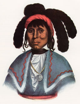
Osceola, named Billy Powell at birth in Alabama, became an influential leader of the Seminole people in Florida. His mother was Muscogee, and his great-grandfather was a Scotsman, James McQueen. He was reared by his mother in the Creek (Muscogee) tradition. When he was a child, they migrated to Florida with other Red Stick refugees, led by a relative, Peter McQueen, after their group's defeat in 1814 in the Creek Wars. There they became part of what was known as the Seminole people.

The Second Seminole War, also known as the Florida War, was a conflict from 1835 to 1842 in Florida between the United States and groups of people collectively known as Seminoles, consisting of Creek and Black Seminoles as well as other allied tribes. It was part of a series of conflicts called the Seminole Wars. The Second Seminole War, often referred to as the Seminole War, is regarded as "the longest and most costly of the Indian conflicts of the United States". After the Treaty of Payne's Landing in 1832 that called for the Seminoles' removal from Florida, tensions rose until fierce hostilities occurred in Dade's massacre in 1835. This engagement officially started the war although there were a series of incidents leading up to the Dade battle. The Seminoles and the U.S. forces engaged in mostly small engagements for more than six years. By 1842, only a few hundred native peoples remained in Florida. Although no peace treaty was ever signed, the war was declared over on August 14, 1842 by Colonel William Jenkins Worth.

The American Indian Wars, also known as the American Frontier Wars, and the Indian Wars, was a conflict initially fought by European colonial empires, United States of America, and briefly the Confederate States of America and Republic of Texas against various American Indian tribes in North America. These conflicts occurred from the time of the earliest colonial settlements in the 17th century until the end of the 19th century. The various wars resulted from a wide variety of factors, the most common being the desire of settlers and governments for Indian tribes' lands. The European powers and their colonies enlisted allied Indian tribes to help them conduct warfare against each other's colonial settlements. After the American Revolution, many conflicts were local to specific states or regions and frequently involved disputes over land use; some entailed cycles of violent reprisal.
Fort Hall was a fort in the Western United States that was built in 1834 as a fur trading post by Nathaniel Jarvis Wyeth. It was located on the Snake River in the eastern Oregon Country, now part of present-day Bannock County in southeastern Idaho. Wyeth was an inventor and businessman from Boston, Massachusetts, who also founded a post at Fort William, in present-day Portland, Oregon, as part of a plan for a new trading and fisheries company. In 1837, unable to compete with the powerful British Hudson's Bay Company, based at Fort Vancouver, Wyeth sold both posts to it. Great Britain and the United States both operated in the Oregon Country in these years.

Fort Laramie was a significant 19th-century trading post, diplomatic site, and military installation located at the confluence of the Laramie and the North Platte Rivers. They joined in the upper Platte River Valley in the eastern part of the present-day US state of Wyoming. The fort was founded as a private trading-post in the 1830s to service the overland fur trade; in 1849, it was purchased by the United States Army. The site was located east of the long climb leading to the best and lowest crossing-point over the Rocky Mountains at South Pass and became a popular stopping-point for migrants on the Oregon Trail. Along with Bent's Fort on the Arkansas River, the trading post and its supporting industries and businesses were the most significant economic hub of commerce in the region.
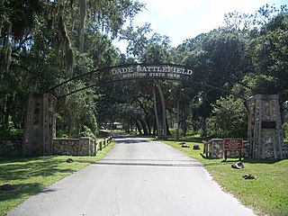
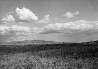
Dade Battlefield Historic State Park is a state park located on County Road 603 between Interstate 75 and U.S. Route 301 in Sumter County, Florida. The 80-acre (32 ha) park includes 40 acres (160,000 m2) of pine flatwoods and a live oak hammock. Also called the Dade Massacre site, it preserves the Second Seminole War battlefield where tribal Seminole warriors and Black Seminole allies fought soldiers under the command of Major Francis L. Dade on December 28, 1835. Each year, on the weekend after Christmas, the Dade Battlefield Society sponsors a reenactment of the battle that started the Second Seminole War.
Micanopy, also known as Mick-e-no-páh, Micco-Nuppe, Michenopah, Miccanopa, and Mico-an-opa, and Sint-chakkee, was the leading chief of the Seminole during the Second Seminole War.
The Treaty of Payne's Landing was an agreement signed on 9 May 1832 between the government of the United States and several chiefs of the Seminole Indians in the Territory of Florida, before it acquired statehood.

Fort Foster is a Second Seminole War era fort in central Florida, located 9 miles (14 km) south of current-day Zephyrhills in Pasco County.

Fort King was a United States military fort in north central Florida, near what later developed as the city of Ocala. It was named after U.S. Colonel William King, commander of 4th Infantry Regiment and the first governor of the provisional West Florida region.

The Treaty of Moultrie Creek, also known as the Treaty with the Florida Tribes of Indians, was an agreement signed in 1823 between the government of the United States and the chiefs of several groups and bands of Indians living in the present-day state of Florida. The treaty established a reservation in the center of the Florida peninsula. It also ceded all coastal lands to the United States Government, as the U.S. wanted control of overseas trade between the Florida and the Caribbean.

Abiaka, also known as Sam Jones, was a Seminole-Miccosukee chief, warrior, and shaman who fought against the United States during the Seminole Wars. He was born among the Miccosukee people of Georgia, who would migrate south into Florida and become part of the Seminole tribe. He initially rose to prominence among the Seminoles as a powerful shaman. Abiaka became the principal chief of the Seminoles in 1837 during the Seminole Wars. He was a guerrilla warfare tactician and he led the Seminoles at the Battle of Lake Okeechobee, the largest battle of the conflict. Abiaka successfully resisted the United States and its policy of Indian Removal, and his leadership resulted in the continued presence of the Seminole people in Florida.

The Dade battle was an 1835 military defeat for the United States Army.
The Seminole Tribe of Florida is a federally recognized Seminole tribe based in the U.S. state of Florida. Together with the Seminole Nation of Oklahoma and the Miccosukee Tribe of Indians of Florida, it is one of three federally recognized Seminole entities. It received that status in 1957. Today, it has six Indian reservations in Florida.

Hogtown was a 19th-century settlement in and around what is now Westside Park in Gainesville, Florida, United States where a historical marker notes Hogtown's location at that site and is the eponymous outpost of the adjacent Hogtown Creek. Originally a village of Seminoles who raised hogs, the habitation was dubbed "Hogtown" by nearby white people who traded with the Seminoles. Indian artifacts were found at Glen Springs, which empties into Hogtown Creek.

Chipco, also known as Echo Emathla, (1805-1881) was a 19th-century Seminole Indian chief and warrior. He was one of the most prominent Seminole chiefs during the Seminole Wars, and by the end of the conflict he was the main leader of the Muscogee-speaking band of Seminoles in Florida. At a young age, Chipco and his family of Red Sticks fled as refugees to Florida because of the War of 1812, where they joined the Seminole tribe. As Chipco grew older he became a chief and eventually fought against the United States and its policy of Indian Removal. Chipco was one of the Seminole leaders at the Dade Battle, where Seminole warriors successfully ambushed a column of the U.S. Army and killed over 100 U.S. troops. This battle started the Second Seminole War, which Chipco would fight in through its entire duration. By the end of the Seminole Wars, Chipco and his band had successfully resisted the United States and were part of the group of Seminoles who remained in Florida, and they were the only Seminole band who continued living in Central Florida.


