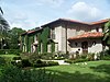
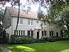
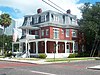
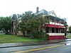
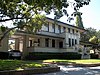
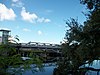
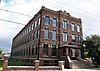
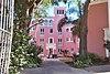
[3] Name on the Register [4] Image Date listed [5] Location Neighborhood Description 1 Anderson-Frank House Anderson-Frank House April 22, 1982 (# 82002375 341 Plant Avenue 27°56′21″N 82°27′48″W / 27.939167°N 82.463333°W / 27.939167; -82.463333 (Anderson-Frank House ) Hyde Park 2 Bay Isle Commercial Building Bay Isle Commercial Building August 3, 1989 (# 89000971 238 East Davis Boulevard 27°55′33″N 82°27′13″W / 27.925833°N 82.453611°W / 27.925833; -82.453611 (Bay Isle Commercial Building ) Davis Islands Part of the Mediterranean Revival Style Buildings of Davis Islands MPS 3 Centro Asturiano Centro Asturiano July 24, 1974 (# 74000631 1913 Nebraska Avenue 27°57′42″N 82°27′03″W / 27.961667°N 82.450833°W / 27.961667; -82.450833 (Centro Asturiano ) V.M. Ybor 4 Circulo Cubano de Tampa Circulo Cubano de Tampa November 15, 1972 (# 72000320 10th Avenue and 14th Street 27°57′39″N 82°26′42″W / 27.960833°N 82.445°W / 27.960833; -82.445 (Circulo Cubano de Tampa ) Ybor City 5 William E. Curtis House William E. Curtis House August 27, 1987 (# 87001424 808 East Curtis Street 27°59′16″N 82°27′46″W / 27.987778°N 82.462778°W / 27.987778; -82.462778 (William E. Curtis House ) Southeast Seminole Heights 6 El Centro Español de Tampa El Centro Español de Tampa June 3, 1988 (# 88001823 1526-1536 East Seventh Avenue 27°57′36″N 82°26′31″W / 27.96°N 82.441944°W / 27.96; -82.441944 (El Centro Español de Tampa ) Ybor City 7 El Centro Espanol of West Tampa El Centro Espanol of West Tampa July 30, 1974 (# 74000632 2306 North Howard Street 27°57′41″N 82°29′00″W / 27.961389°N 82.483333°W / 27.961389; -82.483333 (El Centro Espanol of West Tampa ) West Tampa 8 El Pasaje El Pasaje November 15, 1972 (# 72000321 14th Street and Palm Avenue 27°57′42″N 82°26′41″W / 27.961667°N 82.444722°W / 27.961667; -82.444722 (El Pasaje ) Ybor City 9 Episcopal House of Prayer Episcopal House of Prayer February 21, 1991 (# 91000105 2708 Central Avenue 27°58′00″N 82°27′20″W / 27.966667°N 82.455556°W / 27.966667; -82.455556 (Episcopal House of Prayer ) Tampa Heights 10 Federal Building, U.S. Courthouse, Downtown Postal Station Federal Building, U.S. Courthouse, Downtown Postal Station June 7, 1974 (# 74000633 601 Florida Avenue 27°56′59″N 82°27′27″W / 27.949722°N 82.4575°W / 27.949722; -82.4575 (Federal Building, U.S. Courthouse, Downtown Postal Station ) Downtown Tampa 11 Federal Office Building Upload image September 6, 2022 (# 100008119 500 East Zack St. 27°57′03″N 82°27′25″W / 27.950865°N 82.456898°W / 27.950865; -82.456898 (Federal Office Building ) Downtown Tampa 12 First Federal Savings and Loan Association of Tampa First Federal Savings and Loan Association of Tampa October 17, 2018 (# 100003023 220 East Madison St. 27°56′54″N 82°27′31″W / 27.9483°N 82.4585°W / 27.9483; -82.4585 (First Federal Savings and Loan Association of Tampa ) Downtown Tampa 13 Floridan Hotel Floridan Hotel March 12, 1996 (# 96000315 905 North Florida Avenue 27°57′06″N 82°26′54″W / 27.951667°N 82.448333°W / 27.951667; -82.448333 (Floridan Hotel ) Downtown Tampa 14 Fort Homer W. Hesterly National Guard Armory Fort Homer W. Hesterly National Guard Armory October 23, 2013 (# 13000852 522 N. Howard Ave. 27°56′59″N 82°29′02″W / 27.949601°N 82.484021°W / 27.949601; -82.484021 (Fort Homer W. Hesterly National Guard Armory ) West Tampa 15 Isaac Gardner Sr. House Isaac Gardner Sr. House October 13, 2003 (# 03001013 209 West Palm Avenue 27°57′51″N 82°27′47″W / 27.964167°N 82.463056°W / 27.964167; -82.463056 (Isaac Gardner Sr. House ) Tampa Heights 16 George Guida Sr. House George Guida Sr. House March 29, 2006 (# 06000193 1516 North Renfrew Avenue 27°57′31″N 82°29′49″W / 27.958611°N 82.496944°W / 27.958611; -82.496944 (George Guida Sr. House ) McFarlane Park 17 Hampton Terrace Historic District Hampton Terrace Historic District January 27, 1999 (# 99000045 Roughly bounded by Hanna Avenue, 15th Street, Hillsborough Avenue, and Nebraska Avenue 27°59′58″N 82°26′50″W / 27.999444°N 82.447222°W / 27.999444; -82.447222 (Hampton Terrace Historic District ) Old Seminole Heights 18 Perry Harvey Sr. Park Skateboard Bowl Perry Harvey Sr. Park Skateboard Bowl October 7, 2013 (# 13000811 900 E. Scott St. 27°57′18″N 82°27′20″W / 27.9550153°N 82.4556193°W / 27.9550153; -82.4556193 (Perry Harvey Sr. Park Skateboard Bowl ) South Nebraska Demolished as part of a renovation of Perry Harvey Sr. Park. [6] [7] 19 House at 36 Aegean Avenue House at 36 Aegean Avenue November 13, 1989 (# 89001964 36 Aegean Avenue 27°56′04″N 82°27′34″W / 27.934444°N 82.459444°W / 27.934444; -82.459444 (House at 36 Aegean Avenue ) Davis Islands Part of the Mediterranean Revival Style Buildings of Davis Islands MPS 20 House at 36 Columbia Drive House at 36 Columbia Drive August 3, 1989 (# 89000966 36 Columbia Drive 27°56′05″N 82°27′26″W / 27.934722°N 82.457222°W / 27.934722; -82.457222 (House at 36 Columbia Drive ) Davis Islands Part of the Mediterranean Revival Style Buildings of Davis Islands MPS 21 House at 53 Aegean Avenue House at 53 Aegean Avenue August 3, 1989 (# 89000955 53 Aegean Avenue 27°55′58″N 82°27′33″W / 27.932778°N 82.459167°W / 27.932778; -82.459167 (House at 53 Aegean Avenue ) Davis Islands Part of the Mediterranean Revival Style Buildings of Davis Islands MPS 22 House at 59 Aegean Avenue House at 59 Aegean Avenue August 3, 1989 (# 89000956 59 Aegean Avenue 27°55′57″N 82°27′33″W / 27.9325°N 82.459167°W / 27.9325; -82.459167 (House at 59 Aegean Avenue ) Davis Islands Part of the Mediterranean Revival Style Buildings of Davis Islands MPS 23 House at 84 Adalia Avenue House at 84 Adalia Avenue August 3, 1989 (# 89000953 84 Adalia Avenue 27°55′51″N 82°27′40″W / 27.930833°N 82.461111°W / 27.930833; -82.461111 (House at 84 Adalia Avenue ) Davis Islands Part of the Mediterranean Revival Style Buildings of Davis Islands MPS 24 House at 97 Adriatic Avenue House at 97 Adriatic Avenue August 3, 1989 (# 89000954 97 Adriatic Avenue 27°55′55″N 82°27′37″W / 27.931944°N 82.460278°W / 27.931944; -82.460278 (House at 97 Adriatic Avenue ) Davis Islands Part of the Mediterranean Revival Style Buildings of Davis Islands MPS 25 House at 100 West Davis Boulevard House at 100 West Davis Boulevard August 3, 1989 (# 89000972 100 West Davis Boulevard 27°55′48″N 82°27′25″W / 27.93°N 82.456944°W / 27.93; -82.456944 (House at 100 West Davis Boulevard ) Davis Islands Part of the Mediterranean Revival Style Buildings of Davis Islands MPS 26 House at 116 West Davis Boulevard House at 116 West Davis Boulevard August 3, 1989 (# 89000973 116 West Davis Boulevard 27°55′42″N 82°27′27″W / 27.928333°N 82.4575°W / 27.928333; -82.4575 (House at 116 West Davis Boulevard ) Davis Islands Part of the Mediterranean Revival Style Buildings of Davis Islands MPS 27 House at 124 Baltic Circle House at 124 Baltic Circle August 3, 1989 (# 89000957 124 Baltic Circle 27°55′48″N 82°27′33″W / 27.93°N 82.459167°W / 27.93; -82.459167 (House at 124 Baltic Circle ) Davis Islands Part of the Mediterranean Revival Style Buildings of Davis Islands MPS 28 House at 125 Baltic Circle House at 125 Baltic Circle August 3, 1989 (# 89000958 125 Baltic Circle 27°55′48″N 82°27′30″W / 27.93°N 82.458333°W / 27.93; -82.458333 (House at 125 Baltic Circle ) Davis Islands Part of the Mediterranean Revival Style Buildings of Davis Islands MPS 29 House at 131 West Davis Boulevard House at 131 West Davis Boulevard January 8, 1990 (# 89002161 131 West Davis Boulevard 27°55′38″N 82°27′28″W / 27.927222°N 82.457778°W / 27.927222; -82.457778 (House at 131 West Davis Boulevard ) Davis Islands Part of the Mediterranean Revival Style Buildings of Davis Islands MPS 30 House at 132 Baltic Circle House at 132 Baltic Circle August 3, 1989 (# 89000959 132 Baltic Circle 27°55′46″N 82°27′31″W / 27.929444°N 82.458611°W / 27.929444; -82.458611 (House at 132 Baltic Circle ) Davis Islands Part of the Mediterranean Revival Style Buildings of Davis Islands MPS 31 House at 161 Bosporous Avenue House at 161 Bosporous Avenue August 3, 1989 (# 89000963 161 Bosporous Avenue 27°55′33″N 82°27′26″W / 27.925833°N 82.457222°W / 27.925833; -82.457222 (House at 161 Bosporous Avenue ) Davis Islands Part of the Mediterranean Revival Style Buildings of Davis Islands MPS 32 House at 190 Bosporous Avenue House at 190 Bosporous Avenue August 3, 1989 (# 89000964 190 Bosporous Avenue 27°55′31″N 82°27′27″W / 27.925278°N 82.4575°W / 27.925278; -82.4575 (House at 190 Bosporous Avenue ) Davis Islands Part of the Mediterranean Revival Style Buildings of Davis Islands MPS 33 House at 200 Corsica Avenue House at 200 Corsica Avenue August 3, 1989 (# 89000967 200 Corsica Avenue 27°55′31″N 82°27′38″W / 27.925278°N 82.460556°W / 27.925278; -82.460556 (House at 200 Corsica Avenue ) Davis Islands Part of the Mediterranean Revival Style Buildings of Davis Islands MPS 34 House at 202 Blanca Avenue House at 202 Blanca Avenue August 3, 1989 (# 89000960 202 Blanca Avenue 27°55′36″N 82°27′42″W / 27.926667°N 82.461667°W / 27.926667; -82.461667 (House at 202 Blanca Avenue ) Davis Islands Part of the Mediterranean Revival Style Buildings of Davis Islands MPS 35 House at 220 Blanca Avenue House at 220 Blanca Avenue August 3, 1989 (# 89000961 220 Blanca Avenue 27°55′31″N 82°27′39″W / 27.925278°N 82.460833°W / 27.925278; -82.460833 (House at 220 Blanca Avenue ) Davis Islands Part of the Mediterranean Revival Style Buildings of Davis Islands MPS 36 House at 301 Caspian Street House at 301 Caspian Street August 3, 1989 (# 89000965 301 Caspian Street 27°55′27″N 82°27′34″W / 27.924167°N 82.459444°W / 27.924167; -82.459444 (House at 301 Caspian Street ) Davis Islands Part of the Mediterranean Revival Style Buildings of Davis Islands MPS 37 House at 418 Blanca Avenue House at 418 Blanca Avenue August 3, 1989 (# 89000962 418 Blanca Avenue 27°55′17″N 82°27′33″W / 27.921389°N 82.459167°W / 27.921389; -82.459167 (House at 418 Blanca Avenue ) Davis Islands Part of the Mediterranean Revival Style Buildings of Davis Islands MPS 38 Hutchinson House Hutchinson House November 1, 1977 (# 77000404 304 Plant Avenue 27°56′28″N 82°27′46″W / 27.941111°N 82.462778°W / 27.941111; -82.462778 (Hutchinson House ) Hyde Park 39 Hyde Park Historic Districts Hyde Park Historic Districts March 4, 1985 (# 85000454 Roughly bounded by the Hillsborough River and Bay, Howard Avenue, and Kennedy Boulevard 27°56′11″N 82°28′23″W / 27.936389°N 82.473056°W / 27.936389; -82.473056 (Hyde Park Historic Districts ) Hyde Park 40 Captain William Parker Jackson House Captain William Parker Jackson House April 8, 2011 (# 11000159 800 E Lambright St 28°00′24″N 82°27′09″W / 28.006667°N 82.4525°W / 28.006667; -82.4525 (Captain William Parker Jackson House ) Old Seminole Heights 41 Jackson Rooming House Jackson Rooming House March 7, 2007 (# 07000112 851 Zack Street 27°57′08″N 82°27′07″W / 27.952222°N 82.451944°W / 27.952222; -82.451944 (Jackson Rooming House ) Downtown Tampa 42 Johnson-Wolff House Johnson-Wolff House July 24, 1974 (# 74000634 6823 South DeSoto Street 27°51′59″N 82°31′34″W / 27.866389°N 82.526111°W / 27.866389; -82.526111 (Johnson-Wolff House ) Port Tampa City 43 S. H. Kress and Co. Building S. H. Kress and Co. Building April 7, 1983 (# 83001424 811 North Franklin Street 27°57′03″N 82°27′34″W / 27.950833°N 82.459444°W / 27.950833; -82.459444 (S. H. Kress and Co. Building ) Downtown Tampa 44 Lafayette Street Bridge Lafayette Street Bridge February 20, 2018 (# 100002094 Kennedy Boulevard over Hillsboro R. 27°56′48″N 82°27′40″W / 27.946667°N 82.461111°W / 27.946667; -82.461111 (Lafayette Street Bridge ) Downtown Tampa Better known today as the Kennedy Blvd . Drawbridge. 45 LeClaire Apartments LeClaire Apartments November 16, 1988 (# 88001697 3013-3015 San Carlos 27°55′22″N 82°29′37″W / 27.922778°N 82.493611°W / 27.922778; -82.493611 (LeClaire Apartments ) Palma Ceia 46 Leiman House Leiman House September 9, 1974 (# 74000635 716 South Newport Avenue 27°56′08″N 82°28′18″W / 27.935556°N 82.471667°W / 27.935556; -82.471667 (Leiman House ) Hyde Park 47 Masonic Temple No. 25 Masonic Temple No. 25 September 11, 1986 (# 86002415 508 East Kennedy Boulevard 27°56′54″N 82°27′04″W / 27.948333°N 82.451111°W / 27.948333; -82.451111 (Masonic Temple No. 25 ) Downtown Tampa 48 Meacham Elementary School Meacham Elementary School September 15, 2005 (# 05001041 1225 India Street 27°57′19″N 82°27′11″W / 27.955278°N 82.453056°W / 27.955278; -82.453056 (Meacham Elementary School ) South Nebraska Part of the Florida's Historic Black Public Schools MPS . In 2007, the school building was demolished as part of a redevelopment project of the area. [8] 49 Michigan Avenue Bridge Michigan Avenue Bridge September 25, 2017 (# 100001669 Columbus Dr. over the Hillsborough R. 27°58′00″N 82°28′31″W / 27.966793°N 82.475174°W / 27.966793; -82.475174 (Michigan Avenue Bridge ) Old West Tampa , Riverside Heights , and Ridgewood Park Better known today as the Columbus Drive Swing Span Bridge. 50 North Franklin Street Historic District North Franklin Street Historic District March 28, 2002 (# 02000264 Roughly bounded by Florida Avenue and East Fortune, Tampa, Franklin, and East Harrison Streets 27°57′15″N 82°27′37″W / 27.954167°N 82.460278°W / 27.954167; -82.460278 (North Franklin Street Historic District ) Downtown Tampa 51 Oaklawn and St. Louis Cemeteries Historic District Oaklawn and St. Louis Cemeteries Historic District September 25, 2017 (# 100001668 606 E. Harriston St. 27°57′14″N 82°27′26″W / 27.953928°N 82.45721°W / 27.953928; -82.45721 (Oaklawn and St. Louis Cemeteries Historic District ) Downtown Tampa 52 Old Hillsborough County High School Old Hillsborough County High School May 15, 2007 (# 07000423 2704 North Highland Avenue 27°58′05″N 82°27′47″W / 27.968056°N 82.463056°W / 27.968056; -82.463056 (Old Hillsborough County High School ) Tampa Heights 53 Old People's Home Old People's Home October 17, 2000 (# 00001198 1203 East 22nd Avenue 27°57′41″N 82°26′48″W / 27.961389°N 82.446667°W / 27.961389; -82.446667 (Old People's Home ) V.M. Ybor 54 Old School House Old School House December 4, 1974 (# 74000636 Lafayette Street on the University of Tampa campus 27°56′48″N 82°27′55″W / 27.946667°N 82.465278°W / 27.946667; -82.465278 (Old School House ) University of Tampa 55 Old Tampa Children's Home Old Tampa Children's Home July 22, 1999 (# 99000863 3302 North Tampa Avenue 27°58′27″N 82°27′35″W / 27.974167°N 82.459722°W / 27.974167; -82.459722 (Old Tampa Children's Home ) Tampa Heights 56 Old Tampa Free Public Library Old Tampa Free Public Library May 16, 1991 (# 91000618 102 East Seventh Avenue 27°57′37″N 82°27′38″W / 27.960278°N 82.460556°W / 27.960278; -82.460556 (Old Tampa Free Public Library ) Tampa Heights 57 Old Union Depot Hotel Old Union Depot Hotel December 11, 2000 (# 00001228 858 East Zack Street 27°57′10″N 82°27′05″W / 27.952778°N 82.451389°W / 27.952778; -82.451389 (Old Union Depot Hotel ) Downtown Tampa Demolished [9] 58 Original Rogers Park Golf Course Site Original Rogers Park Golf Course Site November 12, 2014 (# 14000901 7801 N. 30th St. 28°01′20″N 82°25′25″W / 28.022222°N 82.423611°W / 28.022222; -82.423611 (Original Rogers Park Golf Course Site ) Old Seminole Heights 59 Palace of Florence Apartments Palace of Florence Apartments August 3, 1989 (# 89000969 45 East Davis Boulevard 27°56′02″N 82°27′28″W / 27.933889°N 82.457778°W / 27.933889; -82.457778 (Palace of Florence Apartments ) Davis Islands Part of the Mediterranean Revival Style Buildings of Davis Islands MPS 60 Palmerin Hotel Palmerin Hotel August 3, 1989 (# 89000970 115 East Davis Boulevard 27°55′46″N 82°27′22″W / 27.929444°N 82.456111°W / 27.929444; -82.456111 (Palmerin Hotel ) Davis Islands Part of the Mediterranean Revival Style Buildings of Davis Islands MPS 61 Palmetto Beach Historic District Palmetto Beach Historic District August 14, 2012 (# 12000496 Roughly bounded by Durham, 28th, Thrace, & 22nd Streets 27°56′53″N 82°25′53″W / 27.94799°N 82.431364°W / 27.94799; -82.431364 (Palmetto Beach Historic District ) Palmetto Beach 62 Horace T. Robles House Horace T. Robles House March 2, 2006 (# 06000091 2604 East Hanna Avenue 28°00′13″N 82°25′48″W / 28.003611°N 82.43°W / 28.003611; -82.43 (Horace T. Robles House ) Old Seminole Heights 63 Roosevelt Elementary School Roosevelt Elementary School May 31, 2006 (# 06000443 3205 South Ferdinand Avenue 27°54′59″N 82°29′52″W / 27.916389°N 82.497778°W / 27.916389; -82.497778 (Roosevelt Elementary School ) Palma Ceia 64 St. Andrews Episcopal Church St. Andrews Episcopal Church April 15, 2009 (# 09000200 505 N. Marion St. 27°56′58″N 82°27′24″W / 27.949392°N 82.456739°W / 27.949392; -82.456739 (St. Andrews Episcopal Church ) Downtown Tampa 65 Seminole Heights Residential District Seminole Heights Residential District August 5, 1993 (# 93000751 Roughly bounded by Osborne, Florida, Hanna, and Cherokee Avenues 27°59′45″N 82°27′25″W / 27.995833°N 82.456944°W / 27.995833; -82.456944 (Seminole Heights Residential District ) Old Seminole Heights 66 Spanish Apartments Spanish Apartments August 3, 1989 (# 89000968 16 East Davis Boulevard 27°56′08″N 82°27′35″W / 27.935556°N 82.459722°W / 27.935556; -82.459722 (Spanish Apartments ) Davis Islands Part of the Mediterranean Revival Style Buildings of Davis Islands MPS 67 SS AMERICAN VICTORY (Victory ship) SS AMERICAN VICTORY (Victory ship) February 4, 2002 (# 01001533 705 Channelside Dr., Berth 271 27°56′42″N 82°26′39″W / 27.945°N 82.444167°W / 27.945; -82.444167 (SS AMERICAN VICTORY (Victory ship) ) Channel District 68 Stovall House Stovall House September 4, 1974 (# 74000637 4621 Bayshore Boulevard 27°53′47″N 82°29′24″W / 27.896389°N 82.49°W / 27.896389; -82.49 (Stovall House ) Bayshore Beautiful 69 T. C. Taliaferro House T. C. Taliaferro House October 1, 1974 (# 74000638 305 South Hyde Park 27°56′28″N 82°27′52″W / 27.941111°N 82.464444°W / 27.941111; -82.464444 (T. C. Taliaferro House ) Hyde Park 70 Tampa Bay Hotel Tampa Bay Hotel December 5, 1972 (# 72000322 401 West Kennedy Boulevard 27°56′46″N 82°27′51″W / 27.946111°N 82.464167°W / 27.946111; -82.464167 (Tampa Bay Hotel ) Downtown Tampa Includes the Henry B. Plant Museum and the University of Tampa 71 Tampa City Hall Tampa City Hall October 1, 1974 (# 74000639 315 John F. Kennedy Boulevard, East 27°56′50″N 82°27′27″W / 27.947222°N 82.4575°W / 27.947222; -82.4575 (Tampa City Hall ) Downtown Tampa 72 Tampa Heights Historic District Tampa Heights Historic District August 4, 1995 (# 95000979 Roughly bounded by Adalee Street, Interstate 275 , 7th Avenue, and North Tampa Avenue 27°57′54″N 82°27′27″W / 27.965°N 82.4575°W / 27.965; -82.4575 (Tampa Heights Historic District ) Tampa Heights 73 Tampa Theatre and Office Building Tampa Theatre and Office Building January 3, 1978 (# 78000945 711 Franklin Street 27°57′00″N 82°27′32″W / 27.95°N 82.458889°W / 27.95; -82.458889 (Tampa Theatre and Office Building ) Downtown Tampa 74 Tampania House Tampania House September 12, 1985 (# 85002178 4611 North A Street 27°56′45″N 82°30′19″W / 27.945833°N 82.505278°W / 27.945833; -82.505278 (Tampania House ) Oakford Park 75 Union Railroad Station Union Railroad Station June 5, 1974 (# 74000640 601 North Nebraska Street 27°57′08″N 82°27′04″W / 27.952222°N 82.451111°W / 27.952222; -82.451111 (Union Railroad Station ) Downtown and Channel District 76 Upper North Franklin Street Commercial District Upper North Franklin Street Commercial District June 9, 2010 (# 10000344 Bounded by E Oak Ave, N Florida Ave , Kay St, and N Tampa St 27°57′34″N 82°27′37″W / 27.959444°N 82.460278°W / 27.959444; -82.460278 (Upper North Franklin Street Commercial District ) Tampa Heights 77 West Tampa Historic District West Tampa Historic District October 18, 1983 (# 83003539 Roughly bounded by Cypress and Ivy Streets, Fremont and Habana Avenues 27°57′34″N 82°29′02″W / 27.959444°N 82.483889°W / 27.959444; -82.483889 (West Tampa Historic District ) West Tampa 78 Ybor City Historic District Ybor City Historic District August 28, 1974 (# 74000641 Roughly bounded by 6th Avenue, 13th Street, 10th Avenue and 22nd Street, East Broadway between 13th and 22nd Streets 27°57′45″N 82°26′28″W / 27.9625°N 82.441111°W / 27.9625; -82.441111 (Ybor City Historic District ) Ybor City 79 Ybor Factory Building Ybor Factory Building November 15, 1972 (# 72000323 7th Avenue between 13th and 14th Streets 27°57′38″N 82°26′43″W / 27.960556°N 82.445278°W / 27.960556; -82.445278 (Ybor Factory Building ) Ybor City